570:
45:
73:
103:
110:
80:
297:
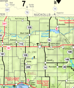
A post office was first established as Delta in 1880, and the settlement was moved to the current site with the arrival of the Rock Island
Railroad, and it was renamed Montrose in 1888. The origin of the name Montrose is obscure.
823:
57:
478:
828:
670:
780:
775:
135:
765:
735:
760:
755:
720:
715:
710:
680:
348:
750:
740:
730:
675:
255:
770:
745:
695:
690:
685:
665:
725:
705:
700:
660:
471:
383:
361:
339:
267:
49:
102:
44:
405:
344:
72:
464:
446:
243:
456:
189:
167:
334:
581:
450:
793:
488:
434:
286:
194:
53:
800:
619:
228:
599:
282:
35:
307:
218:
642:
609:
529:
260:
554:
549:
539:
510:
652:
559:
544:
817:
624:
589:
534:
248:
503:
634:
177:
150:
137:
209:
182:
235:
214:
569:
521:
460:
568:
824:
Unincorporated communities in Jewell County, Kansas
651:
633:
598:
580:
520:
384:"Kansas Post Offices, 1828-1961, page 2 (archived)"
266:
254:
242:
225:
208:
200:
188:
176:
166:
26:
21:Unincorporated community in Kansas, United States
16:Unincorporated community in Jewell County, Kansas
472:
8:
479:
465:
457:
23:
435:List of books about Jewell County, Kansas
573:Map of Kansas highlighting Jewell County
349:United States Department of the Interior
319:
253:
241:
207:
199:
165:
130:
64:
329:
327:
325:
323:
265:
224:
187:
175:
41:
7:
829:Unincorporated communities in Kansas
340:Geographic Names Information System
487:Municipalities and communities of
14:
362:"Kansas Post Offices, 1828-1961"
109:
108:
101:
79:
78:
71:
43:
412:. January 25, 2007. pp. 5B
345:United States Geological Survey
1:
122:Show map of the United States
386:. Kansas Historical Society
364:. Kansas Historical Society
306:The community is served by
845:
432:
204:1,644 ft (501 m)
789:
566:
501:
131:
65:
42:
33:
310:public school district.
283:unincorporated community
36:Unincorporated community
574:
572:
490:Jewell County, Kansas
287:Jewell County, Kansas
227: • Summer (
151:39.78444°N 98.08778°W
802:United States portal
445:Jewell County maps:
410:The Superior Express
406:"Montrose memories"
156:39.78444; -98.08778
147: /
575:
335:"Montrose, Kansas"
308:Rock Hills USD 107
92:Show map of Kansas
811:
810:
289:, United States.
276:
275:
836:
803:
796:
571:
513:
506:
496:
491:
481:
474:
467:
458:
422:
421:
419:
417:
402:
396:
395:
393:
391:
380:
374:
373:
371:
369:
358:
352:
351:
331:
232:
162:
161:
159:
158:
157:
152:
148:
145:
144:
143:
140:
123:
112:
111:
105:
93:
82:
81:
75:
47:
28:Montrose, Kansas
24:
844:
843:
839:
838:
837:
835:
834:
833:
814:
813:
812:
807:
801:
794:
785:
647:
629:
601:
594:
576:
564:
516:
511:
504:
497:
494:
489:
485:
442:
437:
431:
429:Further reading
426:
425:
415:
413:
404:
403:
399:
389:
387:
382:
381:
377:
367:
365:
360:
359:
355:
333:
332:
321:
316:
304:
295:
226:
155:
153:
149:
146:
141:
138:
136:
134:
133:
127:
126:
125:
124:
121:
120:
119:
118:
117:
113:
96:
95:
94:
91:
90:
89:
88:
87:
83:
61:
38:
29:
22:
17:
12:
11:
5:
842:
840:
832:
831:
826:
816:
815:
809:
808:
806:
805:
798:
790:
787:
786:
784:
783:
778:
773:
768:
763:
758:
753:
748:
743:
738:
733:
728:
723:
718:
713:
708:
703:
698:
693:
688:
683:
678:
673:
668:
663:
657:
655:
649:
648:
646:
645:
639:
637:
631:
630:
628:
627:
622:
617:
612:
606:
604:
600:Unincorporated
596:
595:
593:
592:
586:
584:
578:
577:
567:
565:
563:
562:
557:
552:
547:
542:
537:
532:
526:
524:
518:
517:
502:
499:
498:
486:
484:
483:
476:
469:
461:
455:
454:
441:
440:External links
438:
430:
427:
424:
423:
397:
375:
353:
318:
317:
315:
312:
303:
300:
294:
291:
274:
273:
270:
264:
263:
258:
252:
251:
246:
240:
239:
233:
223:
222:
212:
206:
205:
202:
198:
197:
192:
186:
185:
180:
174:
173:
170:
164:
163:
129:
128:
115:
114:
107:
106:
100:
99:
98:
97:
85:
84:
77:
76:
70:
69:
68:
67:
66:
63:
62:
48:
40:
39:
34:
31:
30:
27:
20:
15:
13:
10:
9:
6:
4:
3:
2:
841:
830:
827:
825:
822:
821:
819:
804:
799:
797:
795:Kansas portal
792:
791:
788:
782:
779:
777:
774:
772:
769:
767:
764:
762:
759:
757:
754:
752:
749:
747:
744:
742:
739:
737:
734:
732:
729:
727:
724:
722:
719:
717:
714:
712:
709:
707:
704:
702:
699:
697:
694:
692:
689:
687:
684:
682:
679:
677:
674:
672:
669:
667:
664:
662:
659:
658:
656:
654:
650:
644:
641:
640:
638:
636:
632:
626:
623:
621:
618:
616:
613:
611:
608:
607:
605:
603:
597:
591:
588:
587:
585:
583:
579:
561:
558:
556:
553:
551:
548:
546:
543:
541:
538:
536:
533:
531:
528:
527:
525:
523:
519:
515:
514:
507:
500:
495:United States
492:
482:
477:
475:
470:
468:
463:
462:
459:
452:
448:
444:
443:
439:
436:
428:
411:
407:
401:
398:
385:
379:
376:
363:
357:
354:
350:
346:
342:
341:
336:
330:
328:
326:
324:
320:
313:
311:
309:
301:
299:
292:
290:
288:
284:
280:
271:
269:
262:
259:
257:
250:
247:
245:
237:
234:
230:
220:
216:
213:
211:
203:
196:
193:
191:
184:
181:
179:
172:United States
171:
169:
160:
132:Coordinates:
104:
74:
59:
55:
54:Jewell County
51:
46:
37:
32:
25:
19:
671:Browns Creek
620:North Branch
614:
509:
414:. Retrieved
409:
400:
388:. Retrieved
378:
366:. Retrieved
356:
338:
305:
296:
278:
277:
18:
781:White Mound
635:Ghost towns
602:communities
505:County seat
416:October 18,
154: /
818:Categories
776:Washington
433:See also:
314:References
766:Vicksburg
736:Limestone
653:Townships
302:Education
256:FIPS code
244:Area code
210:Time zone
201:Elevation
142:98°5′16″W
139:39°47′4″N
761:Sinclair
756:Richland
721:Holmwood
716:Highland
711:Harrison
681:Burr Oak
643:Dentonia
615:Montrose
610:Lovewell
530:Burr Oak
451:Historic
390:June 11,
368:June 11,
279:Montrose
261:20-48000
116:Montrose
86:Montrose
751:Prairie
741:Montana
731:Jackson
676:Buffalo
555:Randall
550:Mankato
540:Formoso
512:Mankato
447:Current
293:History
272:472005
268:GNIS ID
168:Country
52:map of
771:Walnut
746:Odessa
696:Erving
691:Center
686:Calvin
666:Athens
560:Webber
545:Jewell
522:Cities
453:, KDOT
281:is an
195:Jewell
190:County
183:Kansas
58:legend
726:Ionia
706:Grant
701:Esbon
661:Allen
625:Otego
590:Ionia
535:Esbon
238:(CDT)
236:UTC-5
215:UTC-6
178:State
418:2015
392:2014
370:2014
50:KDOT
582:CDP
285:in
249:785
229:DST
219:CST
820::
508::
493:,
449:,
408:.
347:,
343:,
337:,
322:^
480:e
473:t
466:v
420:.
394:.
372:.
231:)
221:)
217:(
60:)
56:(
Text is available under the Creative Commons Attribution-ShareAlike License. Additional terms may apply.