62:
740:
95:
128:
203:
45:
223:
135:
102:
69:
367:
The area is known for the historic one-room
Montrose Schoolhouse, built before 1786, which is located in the Colts Neck portion of the community. It was used for many years as a meeting place, religious meeting house, and school house. It last held school classes in 1922, and the last known school
441:
371:
The schoolhouse was donated to the Colts Neck
Historical Society by George Illmensee prior to 1968. It was moved to its present location in 1967 due to building a subdivision. Prior to moving it was located on Montrose Road and Cedar Drive. It was restored at a cost of $ 1006.57.
380:
For many years, Montrose was one of the starting locations for the
Monmouth County Hunt. Sometimes numbering as many as 100 hunters, the community hunts would meet at the Montrose School house, prior to starting out. Fox and rabbits were the focus of the hunts.
1553:
673:
359:
The farms in the area were known for many items, mostly dairy cows, horses, potatoes, and peaches. In 1929, John Koster was noted to have a large greenhouse and sold flowers.
61:
348:. The town was located in "Atlantic Township" at one time prior to the name being changed to "Colts Neck". Prior to being called Montrose, the area was called "Barrentown".
1558:
325:
1415:
1002:
666:
1543:
1255:
415:
163:
1548:
1285:
1485:
1078:
659:
1012:
406:
305:
94:
127:
1007:
987:
952:
914:
651:
411:
351:
The community was electrified in 1928, the fire department was formed in 1926, and a rural mail route was established in 1905.
329:
252:
247:
1350:
1235:
1220:
1168:
992:
977:
769:
321:
235:
35:
44:
1395:
1133:
982:
957:
947:
333:
256:
1103:
997:
967:
929:
819:
705:
1480:
1063:
972:
774:
683:
337:
240:
1495:
1365:
1340:
1290:
1260:
1250:
864:
1513:
1153:
1118:
1073:
1017:
849:
784:
1460:
1420:
1405:
1385:
1225:
1128:
919:
869:
195:
401:
1440:
1430:
1425:
1375:
1370:
1330:
1320:
1275:
1230:
1205:
1200:
1148:
1113:
1093:
1068:
1045:
1035:
924:
909:
814:
804:
729:
724:
1490:
1435:
1380:
1325:
1240:
1215:
1138:
904:
894:
829:
809:
759:
476:
Judy
Cromwell, The Independent, Historical Group Restores 18th century school house, May 5, 1975, Page 10
1500:
1450:
1390:
1355:
1280:
1245:
1210:
1195:
1158:
1143:
1053:
939:
884:
874:
854:
844:
834:
824:
799:
764:
1520:
1470:
1455:
1315:
1310:
1180:
1108:
1098:
1088:
1083:
1027:
899:
879:
751:
290:
1475:
1465:
1410:
1400:
1305:
1300:
1295:
1265:
1185:
1123:
1058:
859:
839:
789:
1445:
1335:
1190:
962:
889:
779:
645:
Red Bank
Register, "Thrills, Spills, Other Excitement in this Fox Hunt", December 3, 1936, Page 1
570:
1345:
716:
280:
794:
1270:
600:
Lois Joice, "To
Preserve The Heritage", Red Bank Register, March 25, 1968, Page 1, Col 2
503:
Red Bank
Register, "HAPPENINGS OF OLD IN AND AROUND OUR HOME TOWN", May 27, 1925, Page 9
467:
Red Bank
Register, "7 Districts in Area Have Board Contests", February 13, 1961, Page 3
297:
276:
1537:
208:
81:
Location in
Monmouth County. Inset: Location of county within the state of New Jersey
636:
Red Bank
Register, "Plan County Hunt Meets for January", December 28, 1939, Page 10
618:
Red Bank Register, "School Restoration Site Seen Available", July 21, 1964, Page 2
428:
698:
446:
582:
Red Bank Register, "Years Ago in and Around Red Bank, February 7, 1934, Page 7
345:
341:
228:
215:
178:
165:
271:
739:
560:
Judy Cromwell, The Independent, Historical Group, May 7, 1975, Page 10
609:
Red Bank Register, "School House Action Taken", July 20, 1965, Page 1
485:
Red Bank Register, "Electricity for Montrose", March 28, 1928, Page 1
627:
Red Bank Register, "Seek to Restore Phalanx", March 31, 1965, Page 1
530:
Red Bank Register, "BIG LOSS OF CHICKENS", October 10, 1928, Page 28
591:
Red Bank Register, "Colts Neck News", September 10, 1930, Page 12
655:
551:
Red Bank Register, "Save the Landmarks", April 20, 1960, page 1
494:
Red Bank Register, "VANDERBURG NEWS", December 1, 1926, Page 24
738:
512:
Red Bank Register, "COLTS NECK NEWS", April 11, 1928, Page 5
539:
Red Bank Register, "COLTS NECK NEWS", April 3, 1929, Page 3
1554:
Unincorporated communities in Monmouth County, New Jersey
521:
Red Bank Register, "Colts Neck", May 14, 1936, Page 14
21:
Unincorporated community in New Jersey, United States
1167:
1044:
1026:
938:
750:
715:
304:
287:
270:
262:
246:
234:
214:
194:
26:
431:, State of New Jersey. Accessed February 27, 2015.
324:located near the intersection of Dutch Lane Road (
16:Populated place in Monmouth County, New Jersey, US
743:Map of New Jersey highlighting Monmouth County
667:
8:
674:
660:
652:
23:
442:"Montrose, Marlboro Township, New Jersey"
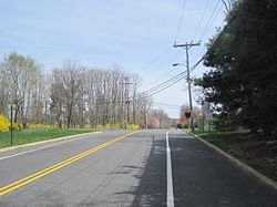
49:Dutch Lane Road approaching Boundary Road
1559:Unincorporated communities in New Jersey
547:
545:
416:United States Department of the Interior
328:) and Boundary Road along the border of
390:
303:
269:
261:
193:
158:
84:Show map of Monmouth County, New Jersey
53:
41:
396:
394:
286:
245:
233:
213:
7:
407:Geographic Names Information System
682:Municipalities and communities of
14:
569:Jeffrey Moser, Living in Media,
221:
201:
134:
133:
126:
101:
100:
93:
68:
67:
60:
43:
1544:Colts Neck Township, New Jersey
412:United States Geological Survey
1:
1549:Marlboro Township, New Jersey
368:bus driver was James Danser.
150:Show map of the United States
147:Montrose (the United States)
685:Monmouth County, New Jersey
1575:
1509:
736:
696:
159:
54:
42:
33:
322:unincorporated community
36:Unincorporated community
266:157 ft (48 m)
744:
117:Show map of New Jersey
742:
289: • Summer (
179:40.30167°N 74.22139°W
114:Montrose (New Jersey)
1522:United States portal
571:Montrose Schoolhouse
363:Historic schoolhouse
28:Montrose, New Jersey
915:Spring Lake Heights
184:40.30167; -74.22139
175: /
1351:Middletown Village
1236:Charleston Springs
1221:Burlington Heights
770:Atlantic Highlands
745:
1531:
1530:
1515:New Jersey portal
1396:North Spring Lake
1134:Shark River Hills
315:
314:
1566:
1523:
1516:
1104:North Middletown
930:West Long Branch
820:Freehold Borough
741:
708:
707:Freehold Borough
701:
691:
686:
676:
669:
662:
653:
646:
643:
637:
634:
628:
625:
619:
616:
610:
607:
601:
598:
592:
589:
583:
580:
574:
573:, March 28, 2005
567:
561:
558:
552:
549:
540:
537:
531:
528:
522:
519:
513:
510:
504:
501:
495:
492:
486:
483:
477:
474:
468:
465:
459:
458:
456:
454:
438:
432:
426:
420:
419:
398:
294:
227:
225:
224:
207:
205:
204:
190:
189:
187:
186:
185:
180:
176:
173:
172:
171:
168:
151:
137:
136:
130:
118:
104:
103:
97:
85:
71:
70:
64:
47:
24:
1574:
1573:
1569:
1568:
1567:
1565:
1564:
1563:
1534:
1533:
1532:
1527:
1521:
1514:
1505:
1481:West Allenhurst
1416:Pleasant Valley
1172:
1170:
1163:
1064:Cliffwood Beach
1040:
1022:
934:
775:Avon-by-the-Sea
746:
734:
711:
706:
699:
692:
689:
684:
680:
650:
649:
644:
640:
635:
631:
626:
622:
617:
613:
608:
604:
599:
595:
590:
586:
581:
577:
568:
564:
559:
555:
550:
543:
538:
534:
529:
525:
520:
516:
511:
507:
502:
498:
493:
489:
484:
480:
475:
471:
466:
462:
452:
450:
440:
439:
435:
429:Locality Search
427:
423:
400:
399:
392:
387:
378:
365:
357:
338:Monmouth County
326:County Route 46
288:
222:
220:
202:
200:
183:
181:
177:
174:
169:
166:
164:
162:
161:
155:
154:
153:
152:
149:
148:
145:
144:
143:
142:
138:
121:
120:
119:
116:
115:
112:
111:
110:
109:
105:
88:
87:
86:
83:
82:
79:
78:
77:
76:
72:
50:
38:
29:
22:
17:
12:
11:
5:
1572:
1570:
1562:
1561:
1556:
1551:
1546:
1536:
1535:
1529:
1528:
1526:
1525:
1518:
1510:
1507:
1506:
1504:
1503:
1498:
1496:West Keansburg
1493:
1488:
1483:
1478:
1473:
1468:
1463:
1458:
1453:
1448:
1443:
1438:
1433:
1428:
1423:
1418:
1413:
1408:
1403:
1398:
1393:
1388:
1383:
1378:
1373:
1368:
1366:Navesink Beach
1363:
1358:
1353:
1348:
1343:
1341:Lower Squankum
1338:
1333:
1328:
1323:
1318:
1313:
1308:
1303:
1298:
1293:
1291:Freewood Acres
1288:
1283:
1278:
1273:
1268:
1263:
1261:East Keansburg
1258:
1253:
1251:Cooleys Corner
1248:
1243:
1238:
1233:
1228:
1223:
1218:
1213:
1208:
1203:
1198:
1193:
1188:
1183:
1177:
1175:
1171:unincorporated
1165:
1164:
1162:
1161:
1156:
1151:
1146:
1141:
1136:
1131:
1126:
1121:
1116:
1111:
1106:
1101:
1096:
1091:
1086:
1081:
1076:
1071:
1066:
1061:
1056:
1050:
1048:
1042:
1041:
1039:
1038:
1032:
1030:
1024:
1023:
1021:
1020:
1015:
1013:Upper Freehold
1010:
1005:
1000:
995:
990:
985:
980:
975:
970:
965:
960:
955:
950:
944:
942:
936:
935:
933:
932:
927:
922:
917:
912:
907:
902:
897:
892:
887:
882:
877:
872:
867:
865:Monmouth Beach
862:
857:
852:
847:
842:
837:
832:
827:
822:
817:
812:
807:
802:
797:
792:
787:
782:
777:
772:
767:
762:
756:
754:
748:
747:
737:
735:
733:
732:
727:
721:
719:
713:
712:
697:
694:
693:
681:
679:
678:
671:
664:
656:
648:
647:
638:
629:
620:
611:
602:
593:
584:
575:
562:
553:
541:
532:
523:
514:
505:
496:
487:
478:
469:
460:
433:
421:
389:
388:
386:
383:
377:
374:
364:
361:
356:
353:
313:
312:
309:
302:
301:
295:
285:
284:
274:
268:
267:
264:
260:
259:
250:
244:
243:
238:
232:
231:
218:
212:
211:
198:
192:
191:
157:
156:
146:
140:
139:
132:
131:
125:
124:
123:
122:
113:
107:
106:
99:
98:
92:
91:
90:
89:
80:
74:
73:
66:
65:
59:
58:
57:
56:
55:
52:
51:
48:
40:
39:
34:
31:
30:
27:
20:
15:
13:
10:
9:
6:
4:
3:
2:
1571:
1560:
1557:
1555:
1552:
1550:
1547:
1545:
1542:
1541:
1539:
1524:
1519:
1517:
1512:
1511:
1508:
1502:
1499:
1497:
1494:
1492:
1489:
1487:
1484:
1482:
1479:
1477:
1474:
1472:
1469:
1467:
1464:
1462:
1459:
1457:
1454:
1452:
1449:
1447:
1444:
1442:
1439:
1437:
1434:
1432:
1429:
1427:
1424:
1422:
1419:
1417:
1414:
1412:
1409:
1407:
1404:
1402:
1399:
1397:
1394:
1392:
1389:
1387:
1384:
1382:
1379:
1377:
1374:
1372:
1369:
1367:
1364:
1362:
1359:
1357:
1354:
1352:
1349:
1347:
1344:
1342:
1339:
1337:
1334:
1332:
1329:
1327:
1324:
1322:
1319:
1317:
1314:
1312:
1309:
1307:
1304:
1302:
1299:
1297:
1294:
1292:
1289:
1287:
1284:
1282:
1279:
1277:
1274:
1272:
1269:
1267:
1264:
1262:
1259:
1257:
1254:
1252:
1249:
1247:
1244:
1242:
1239:
1237:
1234:
1232:
1229:
1227:
1224:
1222:
1219:
1217:
1214:
1212:
1209:
1207:
1204:
1202:
1199:
1197:
1194:
1192:
1189:
1187:
1184:
1182:
1179:
1178:
1176:
1174:
1166:
1160:
1157:
1155:
1154:West Freehold
1152:
1150:
1147:
1145:
1142:
1140:
1137:
1135:
1132:
1130:
1127:
1125:
1122:
1120:
1119:Port Monmouth
1117:
1115:
1112:
1110:
1107:
1105:
1102:
1100:
1097:
1095:
1092:
1090:
1087:
1085:
1082:
1080:
1077:
1075:
1074:East Freehold
1072:
1070:
1067:
1065:
1062:
1060:
1057:
1055:
1052:
1051:
1049:
1047:
1043:
1037:
1034:
1033:
1031:
1029:
1025:
1019:
1016:
1014:
1011:
1009:
1006:
1004:
1001:
999:
996:
994:
991:
989:
986:
984:
981:
979:
976:
974:
971:
969:
966:
964:
961:
959:
956:
954:
951:
949:
946:
945:
943:
941:
937:
931:
928:
926:
923:
921:
918:
916:
913:
911:
908:
906:
903:
901:
898:
896:
893:
891:
888:
886:
883:
881:
878:
876:
873:
871:
868:
866:
863:
861:
858:
856:
853:
851:
850:Little Silver
848:
846:
843:
841:
838:
836:
833:
831:
828:
826:
823:
821:
818:
816:
813:
811:
808:
806:
803:
801:
798:
796:
793:
791:
788:
786:
785:Bradley Beach
783:
781:
778:
776:
773:
771:
768:
766:
763:
761:
758:
757:
755:
753:
749:
731:
728:
726:
723:
722:
720:
718:
714:
710:
709:
702:
695:
690:United States
687:
677:
672:
670:
665:
663:
658:
657:
654:
642:
639:
633:
630:
624:
621:
615:
612:
606:
603:
597:
594:
588:
585:
579:
576:
572:
566:
563:
557:
554:
548:
546:
542:
536:
533:
527:
524:
518:
515:
509:
506:
500:
497:
491:
488:
482:
479:
473:
470:
464:
461:
449:
448:
443:
437:
434:
430:
425:
422:
417:
413:
409:
408:
403:
397:
395:
391:
384:
382:
375:
373:
369:
362:
360:
354:
352:
349:
347:
343:
339:
336:townships in
335:
331:
327:
323:
319:
310:
307:
299:
296:
292:
282:
281:Eastern (EST)
278:
275:
273:
265:
258:
254:
251:
249:
242:
239:
237:
230:
219:
217:
210:
209:United States
199:
197:
188:
160:Coordinates:
129:
96:
63:
46:
37:
32:
25:
19:
1461:Stone Tavern
1421:Port-au-peck
1406:Perrineville
1386:New Monmouth
1360:
1226:Carrs Tavern
1129:Robertsville
920:Tinton Falls
870:Neptune City
704:
641:
632:
623:
614:
605:
596:
587:
578:
565:
556:
535:
526:
517:
508:
499:
490:
481:
472:
463:
453:February 27,
451:. Retrieved
445:
436:
424:
405:
379:
370:
366:
358:
350:
317:
316:
18:
1441:Scobeyville
1431:River Plaza
1426:Prospertown
1376:New Bedford
1371:Nelsonville
1331:Jerseyville
1321:Hornerstown
1276:Emleys Hill
1256:Coxs Corner
1231:Chapel Hill
1206:Bergerville
1201:Bairdsville
1173:communities
1149:West Belmar
1114:Ocean Grove
1094:Morganville
1069:Cream Ridge
1036:Loch Arbour
925:Union Beach
910:Spring Lake
815:Farmingdale
805:Englishtown
730:Long Branch
725:Asbury Park
700:County seat
447:Google Maps
182: /
1538:Categories
1491:West Farms
1436:Red Valley
1381:New Canton
1326:Imlaystown
1241:Clarksburg
1216:Bucks Mill
1139:Strathmore
1008:Shrewsbury
988:Middletown
953:Colts Neck
905:Shrewsbury
895:Sea Bright
830:Interlaken
810:Fair Haven
760:Allenhurst
402:"Montrose"
385:References
346:New Jersey
342:U.S. state
330:Colts Neck
308:feature ID
253:Colts Neck
229:New Jersey
170:74°13′17″W
167:40°18′06″N
1501:Wickatunk
1451:Smithburg
1391:Normandie
1356:Millhurst
1286:Fairfield
1281:Fair Play
1246:Cliffwood
1211:Bradevelt
1196:Arneytown
1159:Yorketown
1144:Wanamassa
1054:Allenwood
993:Millstone
978:Manalapan
940:Townships
885:Roosevelt
875:Oceanport
855:Manasquan
845:Lake Como
835:Keansburg
825:Highlands
800:Eatontown
765:Allentown
376:Hunt club
340:, in the
298:UTC−04:00
277:UTC−05:00
272:Time zone
263:Elevation
1486:West End
1471:Walnford
1456:Squankum
1361:Montrose
1316:Holmeson
1311:Glendola
1181:Adelphia
1109:Oakhurst
1099:Navesink
1089:Lincroft
1084:Leonardo
1079:Fairview
983:Marlboro
958:Freehold
948:Aberdeen
900:Sea Girt
880:Red Bank
752:Boroughs
334:Marlboro
318:Montrose
257:Marlboro
248:Township
241:Monmouth
141:Montrose
108:Montrose
75:Montrose
1476:Wayside
1466:Tennent
1411:Phalanx
1401:Oceanic
1306:Georgia
1301:Galilee
1296:Freneau
1266:Elberon
1186:Allaire
1124:Ramtown
1059:Belford
1028:Village
998:Neptune
968:Holmdel
860:Matawan
840:Keyport
790:Brielle
444:(Map).
355:Farming
196:Country
1446:Sharon
1336:Locust
1191:Ardena
973:Howell
963:Hazlet
890:Rumson
780:Belmar
717:Cities
320:is an
311:878453
236:County
226:
206:
1346:Maxim
1169:Other
1003:Ocean
300:(EDT)
216:State
1046:CDPs
1018:Wall
795:Deal
455:2015
332:and
306:GNIS
255:and
1271:Ely
344:of
291:DST
1540::
703::
688:,
544:^
414:,
410:.
404:.
393:^
675:e
668:t
661:v
457:.
418:.
293:)
283:)
279:(
Text is available under the Creative Commons Attribution-ShareAlike License. Additional terms may apply.