81:
65:
704:
88:
298:
borders
Moshono to the east. Moshono ward is the third largest ward in Arusha Urban District thus its mostly a rural ward with many farming communities and large schools. The ward covers an area of 24.59 km (9.49 sq mi), and has an elevation of 1,348 m (4,423 ft). According
307:
Moshono ward's economy is dominated by schools, health services, NGOs and small scale agriculture. There is a growing suburban community on its eastern borders as the wealthy residents of other wards are moving into the ward because of the attractive landscape and availability of arable land in the
496:
423:
745:
774:
109:
482:
270:
of
Tanzania. It is one of 19 urban administrative wards in the municipality. Moshono ward is bordered by four wards to the north namely;
225:
80:
769:
489:
267:
764:
738:
655:
505:
64:
446:
Kelsall, Tim, and Claire Mercer. "Empowering People? World Vision & 'Transformatory
Development' in Tanzania".
731:
464:
161:
149:
549:
409:
50:
395:
38:
396:"Tanzania: Northern Tanzania (Districts and Wards) - Population Statistics, Charts and Map"
166:
715:
619:
758:
711:
686:
676:
589:
154:
703:
609:
554:
534:
474:
295:
124:
111:
599:
579:
559:
594:
584:
569:
544:
291:
283:
279:
681:
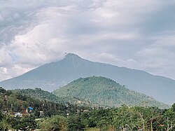
614:
271:
245:
215:
451:
671:
564:
539:
515:
235:
604:
529:
287:
275:
478:
299:
to the 2012 census, the ward had a total population of 20,698
370:
Sombetini ward is home to the following health institutions:
30:
339:
Sombetini ward is home to these educational institutions:
320:. The ward is divided into the following neighbourhoods:
352:
Arusha Modern
Secondary School, Moshono Campus (private)
16:
Ward of Arusha City
Council in Arusha Region of Tanzania
719:
361:
School of St. Jude, Moivaro, Moshono Campus (private)
664:
645:
628:
522:
424:"2012 Population and Housing Census General Report"
251:
241:
231:
224:
214:
206:
198:
193:
185:
177:
172:
160:
148:
140:
24:
465:"Moshono, Arusha Urban, Arusha, Tanzania Pin Code"
739:
490:
8:
746:
732:
497:
483:
475:
21:
450:, vol. 30, no. 96, , 2003, pp. 293–304,
355:Sunflower International School (private)
387:
250:
223:
213:
192:
184:
171:
139:
104:
73:
61:
56:
282:. Moshono is bordered to the west by
266:is an administrative ward located in
240:
230:
205:
197:
176:
159:
147:
7:
700:
698:
316:The postal code for Moshono Ward is
181:24.59 km (9.49 sq mi)
87:
452:http://www.jstor.org/stable/4006766
448:Review of African Political Economy
358:Losirway Secondary School (private)
343:St.Monica Primary School (private)
14:
312:Administration and neighbourhoods
702:
86:
79:
63:
19:Ward in Arusha Region, Tanzania
268:Arusha District, Arusha Region
1:
775:Arusha Region geography stubs
718:. You can help Knowledge by
189:1,297 m (4,255 ft)
656:Arusha Declaration Monument
506:Arusha City Council, Arusha
791:
697:
512:
210:840/km (2,200/sq mi)
105:
74:
62:
57:
48:
429:. Government of Tanzania
346:Moshono Secondary School
125:3.399500°S 36.7407000°E
770:Wards of Arusha Region
714:location article is a
349:Moshono Primary School
242: • Ancestral
69:Meru view Moshono Ward
31:
377:Moivaro Health Center
374:Moshono Health Center
252:Tanzanian Postal Code
130:-3.399500; 36.7407000
765:Wards of Arusha City
232: • Settler
207: • Density
410:"Moshono Elevation"
294:wards. The ward of
121: /
652:Arusha Clock Tower
330:Olkeriyan, Moshono
324:Moivaro, Sombetini
199: • Total
178: • Total
727:
726:
695:
694:
261:
260:
782:
748:
741:
734:
706:
699:
499:
492:
485:
476:
469:
468:
461:
455:
444:
438:
437:
435:
434:
428:
420:
414:
413:
406:
400:
399:
392:
327:Moshono, Moshono
136:
135:
133:
132:
131:
126:
122:
119:
118:
117:
114:
90:
89:
83:
67:
43:
42:
34:
22:
790:
789:
785:
784:
783:
781:
780:
779:
755:
754:
753:
752:
696:
691:
660:
641:
624:
518:
508:
503:
473:
472:
463:
462:
458:
445:
441:
432:
430:
426:
422:
421:
417:
408:
407:
403:
394:
393:
389:
384:
368:
337:
314:
305:
257:
167:Arusha District
129:
127:
123:
120:
115:
112:
110:
108:
107:
101:
100:
99:
98:
97:
96:
95:
91:
70:
58:Kata ya Moshono
53:
44:
36:
32:Kata ya Moshono
29:
27:
20:
17:
12:
11:
5:
788:
786:
778:
777:
772:
767:
757:
756:
751:
750:
743:
736:
728:
725:
724:
707:
693:
692:
690:
689:
684:
679:
674:
668:
666:
662:
661:
659:
658:
653:
649:
647:
643:
642:
640:
639:
636:
632:
630:
626:
625:
623:
622:
620:Terrat, Arusha
617:
612:
607:
602:
597:
592:
587:
582:
577:
572:
567:
562:
557:
552:
547:
542:
537:
532:
526:
524:
520:
519:
513:
510:
509:
504:
502:
501:
494:
487:
479:
471:
470:
456:
439:
415:
401:
386:
385:
383:
380:
379:
378:
375:
367:
364:
363:
362:
359:
356:
353:
350:
347:
344:
336:
333:
332:
331:
328:
325:
313:
310:
304:
301:
259:
258:
255:
253:
249:
248:
243:
239:
238:
233:
229:
228:
222:
221:
218:
212:
211:
208:
204:
203:
200:
196:
195:
191:
190:
187:
183:
182:
179:
175:
174:
170:
169:
164:
158:
157:
152:
146:
145:
142:
138:
137:
103:
102:
93:
92:
85:
84:
78:
77:
76:
75:
72:
71:
68:
60:
59:
55:
54:
49:
46:
45:
28:
25:
18:
15:
13:
10:
9:
6:
4:
3:
2:
787:
776:
773:
771:
768:
766:
763:
762:
760:
749:
744:
742:
737:
735:
730:
729:
723:
721:
717:
713:
712:Arusha Region
708:
705:
701:
688:
685:
683:
680:
678:
675:
673:
670:
669:
667:
665:Ethnic Groups
663:
657:
654:
651:
650:
648:
644:
637:
634:
633:
631:
627:
621:
618:
616:
613:
611:
608:
606:
603:
601:
598:
596:
593:
591:
588:
586:
583:
581:
578:
576:
573:
571:
568:
566:
563:
561:
558:
556:
553:
551:
548:
546:
543:
541:
538:
536:
533:
531:
528:
527:
525:
521:
517:
511:
507:
500:
495:
493:
488:
486:
481:
480:
477:
466:
460:
457:
453:
449:
443:
440:
425:
419:
416:
411:
405:
402:
397:
391:
388:
381:
376:
373:
372:
371:
365:
360:
357:
354:
351:
348:
345:
342:
341:
340:
334:
329:
326:
323:
322:
321:
319:
311:
309:
302:
300:
297:
293:
289:
285:
281:
277:
273:
269:
265:
254:
247:
244:
237:
234:
227:
226:Ethnic groups
219:
217:
209:
201:
188:
180:
168:
165:
163:
156:
155:Arusha Region
153:
151:
143:
134:
116:36°44′26.52″E
106:Coordinates:
82:
66:
52:
47:
40:
33:
23:
720:expanding it
709:
635:Kijenge Hill
610:Unga Limited
574:
535:Daraja Mbili
459:
447:
442:
431:. Retrieved
418:
404:
390:
369:
338:
317:
315:
306:
263:
262:
94:Moshono Ward
26:Moshono Ward
516:Arusha City
128: /
113:3°23′58.2″S
759:Categories
638:Themi Hill
433:2021-11-24
382:References
366:Healthcare
296:Mlangarini
194:Population
646:Monuments
629:Landmarks
600:Sombetini
580:Ngarenaro
560:Kimandolu
514:Capital:
335:Education
186:Elevation
687:Waarusha
595:Sokoni I
585:Oloirien
570:Levolosi
550:Kaloleni
545:Engutoto
292:Engutoto
280:Nkoanrua
220:Moshonan
162:District
144:Tanzania
682:Koningo
615:Olasiti
575:Moshono
303:Economy
284:Olorein
272:Bangata
264:Moshono
246:Kinongo
216:Demonym
141:Country
39:Swahili
677:Maasai
672:Wameru
565:Lemara
540:Elerai
308:ward.
202:20,698
150:Region
35:
710:This
605:Themi
590:Sekei
530:Baraa
523:Wards
427:(PDF)
318:23118
288:Themi
276:Baraa
256:23118
716:stub
555:Kati
290:and
278:and
236:Meru
173:Area
51:Ward
761::
286:,
274:,
747:e
740:t
733:v
722:.
498:e
491:t
484:v
467:.
454:.
436:.
412:.
398:.
41:)
37:(
Text is available under the Creative Commons Attribution-ShareAlike License. Additional terms may apply.