29:
122:
115:
506:
481:
346:
As part of the
Lincoln County Conservation, Recreation, and Development Act signed into law on 30 November 2004, 157,716 acres (63,825 ha) in the area were designated as wilderness. The wilderness is managed by the BLM through their
570:
551:
585:
580:
387:
196:
71:
290:. The south fork of the Toquop Wash drains the east side of the range and continues on through the N–S linear ridge of the East Mormon Mountains.
544:
436:
114:
378:
575:
537:
383:
297:(BLM) and cover approximately 175 square miles (450 km). The Mormon Mountains are home to several different species of
491:
189:
64:
28:
485:
331:
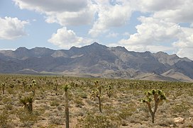
The area is characterized by very low rainfall, receiving less than 15 inches (380 mm) per year, on average.
294:
373:
322:
286:, at 7,414 feet (2,260 m) above sea level. Another smaller mountain range lies to the east, called the
271:
263:
513:
247:
178:
287:
283:
251:
182:
47:
168:
455:
275:
310:
318:
259:
325:
228:
521:
564:
267:
279:
348:
314:
211:
198:
86:
73:
505:
480:
313:
can be found in the region. The lower elevations of the range are mostly
335:
517:
298:
255:
158:
135:
54:
334:
The range was named for the fact a share of the first settlers were
302:
306:
233:
317:, but at higher elevations one can find "pygmy conifers" and
525:
258:, between 16 and 28 miles (45 km) northwest of
227:
188:
174:
164:
154:
146:
102:
63:
53:
43:
38:
21:
410:, 30x60 Minute Topographic Quadrangle, USGS, 1987
293:The mountains fall under the jurisdiction of the
545:
8:
552:
538:
18:
571:Mountain ranges of Lincoln County, Nevada
388:United States Department of the Interior
121:
418:
416:
360:
586:Lincoln County, Nevada geography stubs
368:
366:
364:
7:
502:
500:
492:Biological Resources Research Center
338:. A variant name is "Mormon Range".
282:. The highest point in the range is
379:Geographic Names Information System
581:Mountain ranges of the Great Basin
14:
435:Federal Writers' Project (1941).
425:7.5 Minute Quadrangle, USGS, 1969
16:American mountain range in Nevada
504:
479:
134:location of Mormon Mountains in
120:
113:
27:
384:United States Geological Survey
456:"Mormon Mounatains Wilderness"
1:
438:Origin of Place Names: Nevada
524:. You can help Knowledge by
520:state location article is a
59:2,260 m (7,410 ft)
342:Mormon Mountains Wilderness
602:
499:
576:Mountain ranges of Nevada
295:Bureau of Land Management
107:
26:
319:single-leaf pinyon pines
408:Overton, Nevada–Arizona
323:Pinyon-juniper woodland
272:Meadow Valley Mountains
423:Moapa Peak NW, Nevada,
212:36.94806°N 114.46028°W
87:36.97417°N 114.50056°W
288:East Mormon Mountains
488:at Wikimedia Commons
444:. W.P.A. p. 45.
217:36.94806; -114.46028
92:36.97417; -114.50056
236: Moapa Peak NW
208: /
169:Great Basin section
83: /
374:"Mormon Mountains"
39:Highest point
533:
532:
484:Media related to
351:District office.
278:and northeast of
240:
239:
190:Range coordinates
593:
554:
547:
540:
508:
501:
486:Mormon Mountains
483:
467:
466:
464:
462:
452:
446:
445:
443:
432:
426:
420:
411:
405:
399:
398:
396:
394:
370:
244:Mormon Mountains
223:
222:
220:
219:
218:
213:
209:
206:
205:
204:
201:
128:Mormon Mountains
124:
123:
117:
98:
97:
95:
94:
93:
88:
84:
81:
80:
79:
76:
33:Mormon Mountains
31:
22:Mormon Mountains
19:
601:
600:
596:
595:
594:
592:
591:
590:
561:
560:
559:
558:
497:
476:
471:
470:
460:
458:
454:
453:
449:
441:
434:
433:
429:
421:
414:
406:
402:
392:
390:
372:
371:
362:
357:
344:
326:plant community
246:are located in
216:
214:
210:
207:
202:
199:
197:
195:
194:
142:
141:
140:
139:
138:
132:
131:
130:
129:
125:
91:
89:
85:
82:
77:
74:
72:
70:
69:
34:
17:
12:
11:
5:
599:
597:
589:
588:
583:
578:
573:
563:
562:
557:
556:
549:
542:
534:
531:
530:
514:Lincoln County
509:
495:
494:
489:
475:
474:External links
472:
469:
468:
447:
427:
412:
400:
359:
358:
356:
353:
343:
340:
270:, east of the
238:
237:
231:
225:
224:
192:
186:
185:
179:Lincoln County
176:
172:
171:
166:
162:
161:
156:
152:
151:
148:
144:
143:
133:
127:
126:
119:
118:
112:
111:
110:
109:
108:
105:
104:
100:
99:
67:
61:
60:
57:
51:
50:
45:
41:
40:
36:
35:
32:
24:
23:
15:
13:
10:
9:
6:
4:
3:
2:
598:
587:
584:
582:
579:
577:
574:
572:
569:
568:
566:
555:
550:
548:
543:
541:
536:
535:
529:
527:
523:
519:
515:
510:
507:
503:
498:
493:
490:
487:
482:
478:
477:
473:
457:
451:
448:
440:
439:
431:
428:
424:
419:
417:
413:
409:
404:
401:
389:
385:
381:
380:
375:
369:
367:
365:
361:
354:
352:
350:
341:
339:
337:
332:
329:
327:
324:
320:
316:
312:
308:
304:
301:, and ground
300:
296:
291:
289:
285:
281:
277:
276:Meadow Valley
273:
269:
268:Virgin Valley
265:
261:
257:
253:
249:
245:
235:
232:
230:
226:
221:
193:
191:
187:
184:
180:
177:
173:
170:
167:
163:
160:
157:
153:
150:United States
149:
145:
137:
116:
106:
101:
96:
68:
66:
62:
58:
56:
52:
49:
46:
42:
37:
30:
25:
20:
526:expanding it
511:
496:
459:. Retrieved
450:
437:
430:
422:
407:
403:
391:. Retrieved
377:
345:
333:
330:
292:
280:Moapa Valley
254:counties in
243:
241:
183:Clark County
461:26 November
284:Mormon Peak
215: /
203:114°27′37″W
90: /
78:114°30′02″W
65:Coordinates
48:Mormon Peak
565:Categories
355:References
315:shrublands
200:36°56′53″N
75:36°58′27″N
321:, in the
311:bullfrogs
103:Geography
55:Elevation
260:Mesquite
229:Topo map
175:District
336:Mormons
299:lizards
266:in the
248:Lincoln
147:Country
518:Nevada
303:snakes
256:Nevada
165:Region
159:Nevada
136:Nevada
512:This
442:(PDF)
393:4 May
307:toads
252:Clark
155:State
522:stub
463:2014
395:2009
309:and
274:and
264:I–15
250:and
242:The
234:USGS
181:and
44:Peak
349:Ely
262:on
567::
516:,
415:^
386:,
382:.
376:.
363:^
328:.
305:,
553:e
546:t
539:v
528:.
465:.
397:.
Text is available under the Creative Commons Attribution-ShareAlike License. Additional terms may apply.