53:
81:
33:
88:
60:
412:
North Fork Moreau River, Ash Creek, Mud Creek, Cottonwood Creek, Brady Creek, Cabin Creek, Starve Out Creek, Rabbit Creek, Mud Creek, Berry Creek, Locate Creek, Thunder Butte Creek, Sophia Creek, Irish Creek, Red Earth Creek, Meadow Creek, Redwater Creek, Little Moreau River, Whitehorse Creek, Jewett
423:
Big Cabin Creek, Little Cedar Creek, Deep Creek, Badlands Creek, Flint Rock Creek, Knife Creek, Cottonwood Creek, Ash Creek, Pretty Creek, Bear Creek, Green Grass Creek, Gorge Creek, Cottonwood Creek, Bull Creek, Swan Creek, Johnson Creek, Blue Beaver Creek, Virian Creek, Beaver Creek, Hakshela
439:
536:) has a drainage basin of approximately 5,400 square miles (14,000 km). The Moreau River also has Sand Creek as a source, along with the North and South Forks, and claims several tributaries, such as the Little Moreau, Deep, Red Earth, Antelope, and Thunder Butte Rivers. At
432:
Cedar Canyon Road, Bixby Road, SD 73, unnamed road, Thunder Butte Road, Leadum Pike Road, unnamed road (x4), SD 65, On the Tree Road, SD 63, unnamed road, BIA-3, The Native
American Scenic Byway
755:
52:
831:
826:
816:
80:
821:
836:
185:
263:
811:
630:
621:
549:
739:
502:
413:
Creek, Jolley Creek, Handbou Creek, Marshall Creek, Du Charme Creek, Tom Hill Creek, Laundreaux Creek, Le Beau Creek, Chicken Creek
731:
806:
651:
626:
587:
773:
489:
rises approximately 20 miles (32 km) west of the headwaters of the North Fork. The two forks flow ESE and unite near
532:, running from west to east to join the Missouri. Draining the Pierre Hills and Northern Plateaus, the Moreau (formerly
494:
474:
144:
140:
136:
706:
529:
470:
132:
506:
514:
518:
38:
616:
710:
32:
537:
249:
490:
498:
482:
438:
735:
374:
680:
540:, the river averages a flow of 296 cubic feet per second (8.4 cubic metres per second).
451:
392:
386:
378:
370:
351:
338:
236:
800:
781:
525:, with the lower 25 miles (40 km) of the river forming an arm of the reservoir.
510:
459:
528:
The river generally parallels its neighbor 40 miles (64 km) to the north, the
455:
756:"USGS Surface Water data for South Dakota: USGS Surface-Water Annual Statistics"
231:
278:
265:
200:
187:
522:
173:
about 4 miles east-northeast of the intersection 156th Street and Zeona Road
466:
442:
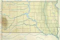
The Moreau River, highlighted on a map of the
Missouri River watershed
730:(Third ed.). Sioux Falls, SD: The Center for Western Studies –
437:
715:. American guide series. University of South Dakota. p. 6.
465:
It rises in two forks in northwestern South Dakota, in the
350:
337.63 cu ft/s (9.561 m/s) at mouth with
481:
rises approximately 10 miles (16 km) northeast of
726:Hogan, Edward Patrick; Fouberg, Erin Hogan (2001).
428:
417:
406:
398:
384:
366:
361:
344:
332:
324:
312:
304:
294:
255:
242:
230:
216:
177:
167:
159:
150:
128:
120:
112:
107:
87:
59:
21:
163:confluence of South and North Fork of Moreau River
462:. Moreau River has the name of a pioneer trader.
454:, approximately 200 miles (320 km) long, in
95:Moreau River (South Dakota) (the United States)
681:"Watershed Report | Office of Water | US EPA"
8:
675:
673:
552:, it has also been known historically as:
631:United States Department of the Interior
316:5,435.32 square miles (14,077.4 km)
599:
497:. The combined stream flows east, past
832:Rivers of Ziebach County, South Dakota
827:Rivers of Perkins County, South Dakota
817:Rivers of Harding County, South Dakota
611:
609:
607:
605:
603:
18:
822:Rivers of Custer County, South Dakota
7:
837:Rivers of Dewey County, South Dakota
622:Geographic Names Information System
550:Geographic Names Information System
14:
812:Tributaries of the Missouri River
503:Cheyenne River Indian Reservation
86:
79:
58:
51:
31:
627:United States Geological Survey
308:290.75 mi (467.92 km)
588:List of rivers of South Dakota
257: • coordinates
179: • coordinates
67:Location of Moreau River mouth
1:
728:The Geography of South Dakota
712:South Dakota place-names, v.3
151:Physical characteristics
98:Show map of the United States
296: • elevation
218: • elevation
521:. It joins the Missouri in
334: • location
244: • location
169: • location
25:Tributary to Missouri River
16:Stream in South Dakota, USA
853:
778:panhandletrails.weebly.com
346: • average
300:1,614 ft (492 m)
222:2,490 ft (760 m)
357:
320:
226:
155:
45:
30:
707:Federal Writers' Project
652:"ArcGIS Web Application"
419: • right
70:Show map of South Dakota
577:Sur war har na ha River
408: • left
248:about 10 miles west of
807:Rivers of South Dakota
450:is a tributary of the
443:
201:45.14444°N 102.83926°W
441:
424:Creek, No Mouth Creek
279:45.3247°N 100.3331°W
250:Akaska, South Dakota
206:45.14444; -102.83926
37:The Moreau River at
656:epa.maps.arcgis.com
362:Basin features
275: /
197: /
444:
284:45.3247; -100.3331
732:Augustana College
685:watersgeo.epa.gov
559:Cerwercerna River
548:According to the
501:, and across the
436:
435:
375:Mississippi River
844:
793:
791:
789:
780:. Archived from
760:
759:
752:
746:
745:
723:
717:
716:
703:
697:
696:
694:
692:
677:
668:
667:
665:
663:
648:
642:
641:
639:
637:
613:
420:
409:
389:
347:
335:
290:
289:
287:
286:
285:
280:
276:
273:
272:
271:
268:
219:
212:
211:
209:
208:
207:
202:
198:
195:
194:
193:
190:
180:
170:
99:
90:
89:
83:
71:
62:
61:
55:
35:
19:
852:
851:
847:
846:
845:
843:
842:
841:
797:
796:
787:
785:
772:
769:
764:
763:
754:
753:
749:
742:
725:
724:
720:
705:
704:
700:
690:
688:
679:
678:
671:
661:
659:
650:
649:
645:
635:
633:
615:
614:
601:
596:
584:
546:
418:
407:
385:
345:
333:
297:
283:
281:
277:
274:
269:
266:
264:
262:
261:
258:
245:
217:
205:
203:
199:
196:
191:
188:
186:
184:
183:
178:
168:
143:
139:
135:
103:
102:
101:
100:
97:
96:
93:
92:
91:
74:
73:
72:
69:
68:
65:
64:
63:
41:
26:
23:
17:
12:
11:
5:
850:
848:
840:
839:
834:
829:
824:
819:
814:
809:
799:
798:
795:
794:
784:on 7 June 2021
768:
767:External links
765:
762:
761:
747:
740:
718:
698:
669:
643:
617:"Moreau River"
598:
597:
595:
592:
591:
590:
583:
580:
579:
578:
575:
572:
569:
566:
565:Main Owl River
563:
560:
557:
545:
542:
507:Iron Lightning
495:Perkins County
477:Counties. The
452:Missouri River
434:
433:
430:
426:
425:
421:
415:
414:
410:
404:
403:
400:
396:
395:
393:Missouri River
390:
382:
381:
379:Gulf of Mexico
371:Missouri River
368:
364:
363:
359:
358:
355:
354:
352:Missouri River
348:
342:
341:
339:Missouri River
336:
330:
329:
326:
322:
321:
318:
317:
314:
310:
309:
306:
302:
301:
298:
295:
292:
291:
259:
256:
253:
252:
246:
243:
240:
239:
237:Missouri River
234:
228:
227:
224:
223:
220:
214:
213:
181:
175:
174:
171:
165:
164:
161:
157:
156:
153:
152:
148:
147:
130:
126:
125:
122:
118:
117:
114:
110:
109:
105:
104:
94:
85:
84:
78:
77:
76:
75:
66:
57:
56:
50:
49:
48:
47:
46:
43:
42:
36:
28:
27:
24:
15:
13:
10:
9:
6:
4:
3:
2:
849:
838:
835:
833:
830:
828:
825:
823:
820:
818:
815:
813:
810:
808:
805:
804:
802:
783:
779:
775:
771:
770:
766:
757:
751:
748:
743:
741:0-931170-79-6
737:
733:
729:
722:
719:
714:
713:
708:
702:
699:
686:
682:
676:
674:
670:
657:
653:
647:
644:
632:
628:
624:
623:
618:
612:
610:
608:
606:
604:
600:
593:
589:
586:
585:
581:
576:
573:
570:
567:
564:
561:
558:
556:Big Owl River
555:
554:
553:
551:
544:Variant names
543:
541:
539:
535:
531:
526:
524:
520:
516:
512:
511:Thunder Butte
508:
504:
500:
496:
492:
488:
484:
480:
476:
472:
468:
463:
461:
460:United States
457:
453:
449:
440:
431:
427:
422:
416:
411:
405:
401:
397:
394:
391:
388:
383:
380:
376:
372:
369:
365:
360:
356:
353:
349:
343:
340:
337:
331:
327:
323:
319:
315:
311:
307:
303:
299:
293:
288:
260:
254:
251:
247:
241:
238:
235:
233:
229:
225:
221:
215:
210:
182:
176:
172:
166:
162:
158:
154:
149:
146:
142:
138:
134:
131:
127:
123:
119:
116:United States
115:
111:
106:
82:
54:
44:
40:
34:
29:
20:
786:. Retrieved
782:the original
777:
774:"Crow Butte"
750:
727:
721:
711:
701:
689:. Retrieved
684:
660:. Retrieved
655:
646:
634:. Retrieved
620:
547:
533:
527:
493:in southern
486:
478:
464:
456:South Dakota
448:Moreau River
447:
445:
387:River system
124:South Dakota
22:Moreau River
691:January 15,
662:January 15,
636:January 31,
571:Murow Creek
568:Mistai'yohe
530:Grand River
515:Green Grass
483:Crow Buttes
399:Tributaries
367:Progression
282: /
270:100°19′59″W
204: /
192:102°50′21″W
801:Categories
594:References
562:Hinyankaga
519:Whitehorse
487:South Fork
479:North Fork
313:Basin size
267:45°19′29″N
189:45°08′40″N
39:Whitehorse
574:Owl River
534:Owl River
523:Lake Oahe
325:Discharge
709:(1940).
687:. US EPA
658:. US EPA
582:See also
467:Badlands
129:Counties
108:Location
538:Promise
505:, past
475:Harding
458:in the
429:Bridges
145:Perkins
141:Ziebach
137:Edmunds
113:Country
738:
485:. The
402:
328:
305:Length
160:Source
788:7 May
491:Zeona
471:Butte
232:Mouth
133:Dewey
121:State
790:2021
736:ISBN
693:2023
664:2023
638:2024
517:and
499:Usta
473:and
446:The
469:of
803::
776:.
734:.
683:.
672:^
654:.
629:,
625:.
619:.
602:^
513:,
509:,
377:→
373:→
792:.
758:.
744:.
695:.
666:.
640:.
Text is available under the Creative Commons Attribution-ShareAlike License. Additional terms may apply.