54:
249:. The main beaches of the Morro de São Paulo are located on east side of the island . They are: Primeira Praia, Segunda Praia, Terceira Praia, Quarta Praia and Quinta Praia (also known as Praia do Encanto). The settlement was home to a large Tumpinamba population prior to the arrival of the Portuguese. A Portuguese colony was established as early as 1535. The settlement is a site of large-scale tourism, and has three registered historic sites.
472:
38:
160:
128:
61:
219:
274:
off the Morro de São Paulo
Lighthouse, killing the majority of the 179 passengers. The citizen of Bahia experienced scarcity, speculation, and famine due to the threat of German attack from 1942 to 1945; Morro de São Paulo was largely abandoned by the federal government and suffered from both famine
257:
Martim Afonso de Sousa, landed in 1531 and baptized this island "Tynharéa" and the Bahian accent soon transformed that name to "Tinharé". In 1535 the village of Morro de São Paulo was founded in the extreme north of the island by
Francisco Romero and the local population. Morro de Sao Paulo was the
507:
512:
502:
88:
433:
316:
258:
site of patrols and attacks by German submarines between 1942 and 1945 as part of German naval attacks across the coast of Bahia and
53:
266:. The German government initially targeted merchant ships off Bahia and Sergipe, but civilian casualties were numerous. The
37:
304:
320:
324:
299:
by road and ferry and 60 kilometres (37 mi) by sea. The village is also accessible by direct flights from
145:
120:
475:
369:"Mortes no mar, dor na terra. Brasileiros atingidos pelo ataque do submarino alemão U-507 (agosto de 1942)"
300:
267:
234:
390:
284:
140:
408:
380:
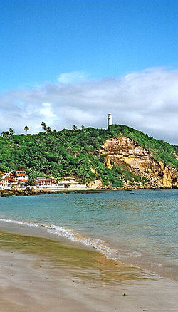
152:
481:
296:
471:
181:
496:
447:
385:
368:
263:
421:
394:
103:
90:
172:
259:
409:"See all work exchanges and volunteer opportunities from Worldpackers"
343:
246:
230:
133:
203:
242:
238:
218:
217:
177:
165:
74:
229:(translation: St. Paul's Hill) is one of 5 villages of the
315:
Morro de São Paulo is home to three historic sites: the
450:(in Portuguese). Patrimônio Cultural da Bahia. 2019
198:
188:
171:
151:
139:
119:
21:
434:"Ajude-nos a não perder a sede da Escola CreArte!"
295:The village is 272 kilometres (169 mi) from
8:
508:1535 establishments in the Portuguese Empire
422:https://www.facebook.com/escolacrearte/.html
60:
18:
384:
335:
197:
187:
170:
118:
83:
46:
34:
73:Location of Morro de São Paulo in the
150:
138:
7:
513:Populated places established in 1535
448:"Fonte Grande do Morro de São Paulo"
317:Fonte Grande of Morro de São Paulo
283:Morro de São Paulo is home to the
14:
503:Populated coastal places in Bahia
287:pedagogy school, Escola CreArte.
42:View of Morro de São Paulo, Bahia
470:
158:
126:
59:
52:
36:
488:(in English, French, and Dutch)
386:10.15448/1980-864X.2017.2.24833
321:Fortaleza do Morro de São Paulo
484:Infos about Morro de São Paulo
1:
325:Morro de São Paulo Lighthouse
478:travel guide from Wikivoyage
16:Village in Northeast, Brazil
529:
348:www.morrodesaopaulo.org.br
241:, located in the state of
84:
47:
35:
28:
373:Estudos Ibero-Americanos
367:Ferreira, Jorge (2017).
237:in the municipality of
268:German submarine U-507
223:
221:
104:13.38167°S 38.91389°W
344:"Morro de São Paulo"
109:-13.38167; -38.91389
222:Morro de São Paulo.
100: /
482:Morro de São Paulo
476:Morro de São Paulo
227:Morro de São Paulo
224:
67:Morro de São Paulo
23:Morro de São Paulo
301:Salvador da Bahia
297:Salvador da Bahia
275:and lawlessness.
216:
215:
520:
489:
474:
459:
458:
456:
455:
444:
438:
437:
430:
424:
419:
413:
412:
405:
399:
398:
388:
364:
358:
357:
355:
354:
340:
212:
209:
207:
206:.morrodesaopaulo
205:
164:
162:
161:
132:
130:
129:
115:
114:
112:
111:
110:
105:
101:
98:
97:
96:
93:
63:
62:
56:
40:
19:
528:
527:
523:
522:
521:
519:
518:
517:
493:
492:
487:
467:
462:
453:
451:
446:
445:
441:
432:
431:
427:
420:
416:
407:
406:
402:
366:
365:
361:
352:
350:
342:
341:
337:
333:
313:
305:Lorenzo Airport
293:
281:
255:
202:
194:
159:
157:
127:
125:
108:
106:
102:
99:
94:
91:
89:
87:
86:
80:
79:
78:
77:
71:
70:
69:
68:
64:
43:
31:
24:
17:
12:
11:
5:
526:
524:
516:
515:
510:
505:
495:
494:
491:
490:
485:
479:
466:
465:External links
463:
461:
460:
439:
425:
414:
400:
359:
334:
332:
329:
312:
311:Historic sites
309:
292:
291:Transportation
289:
280:
277:
254:
251:
214:
213:
200:
196:
195:
192:
190:
186:
185:
175:
169:
168:
155:
149:
148:
143:
137:
136:
123:
117:
116:
82:
81:
75:State of Bahia
72:
66:
65:
58:
57:
51:
50:
49:
48:
45:
44:
41:
33:
32:
29:
26:
25:
22:
15:
13:
10:
9:
6:
4:
3:
2:
525:
514:
511:
509:
506:
504:
501:
500:
498:
486:
483:
480:
477:
473:
469:
468:
464:
449:
443:
440:
435:
429:
426:
423:
418:
415:
410:
404:
401:
396:
392:
387:
382:
378:
374:
370:
363:
360:
349:
345:
339:
336:
330:
328:
326:
322:
318:
310:
308:
306:
302:
298:
290:
288:
286:
278:
276:
273:
270:attacked the
269:
265:
261:
252:
250:
248:
244:
240:
236:
232:
228:
220:
211:
201:
191:
183:
179:
176:
174:
167:
156:
154:
147:
144:
142:
135:
124:
122:
113:
85:Coordinates:
76:
55:
39:
27:
20:
452:. Retrieved
442:
428:
417:
403:
376:
372:
362:
351:. Retrieved
347:
338:
314:
294:
282:
271:
264:World War II
256:
226:
225:
189:Postal Code
107: /
497:Categories
454:2019-12-20
379:(2): 275.
353:2018-03-28
331:References
323:, and the
95:38°54′50″W
92:13°22′54″S
395:1980-864X
279:Education
173:Time zone
146:Northeast
193:45400000
285:Waldorf
272:Itagiba
262:during
260:Sergipe
253:History
235:Tinharé
199:Website
121:Country
30:Village
393:
319:, the
247:Brazil
231:island
163:
141:Region
134:Brazil
131:
243:Bahia
239:Cairu
178:UTC-3
166:Bahia
153:State
391:ISSN
208:.org
381:doi
303:to
233:of
210:.br
204:www
182:BRT
499::
389:.
377:43
375:.
371:.
346:.
327:.
307:.
245:,
457:.
436:.
411:.
397:.
383::
356:.
184:)
180:(
Text is available under the Creative Commons Attribution-ShareAlike License. Additional terms may apply.