61:
156:
45:
68:
231:
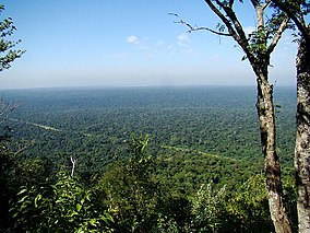
The park preserves one of the last large areas of the country's upland forest, with the original regional ecosystems. The climate is type CWA. Rainfall is mostly in the summer, averaging 1,100 to 1,300 millimetres (43 to 51 in). Average daily temperatures range from 13 °C (55 °F) from
219:. It has an area of 33,845.33 hectares (83,633.6 acres). The park has tropical seasonal semi-deciduous vegetation. The park lets visitors have direct contact with nature in a sustainable manner, and supports environmental education and scientific research. The park would be part of the proposed
262:
in 1917. Urban centers were built along the railway and intensive logging began, followed by farming of coffee, cotton, peanuts and cattle. The state government created the Morro do Diabo Forest
Reserve in 1941, now the Morro do Diabo State Park. In 1942 the 247,000 hectares (610,000 acres)
250:) trees, important for reforestation and recovery of degraded areas. It is home to endangered species such as tapir, peccary, howler monkey, puma and jaguar, and one of the most threatened of all primates, the black lion tamarin, with an estimated 1,200 members of this species.
271:
were created. Over the years that followed these two reserves were invaded by squatters and deforested, often with government support. The forest reserve became a state park in 1986.
489:
499:
96:
232:
May to August to 32 °C (90 °F) from
January to March, with an annual mean temperature of 21 °C (70 °F). The park preserves an area of
60:
494:
287:
167:
223:, which aims to provide forest connections between conservation units in Brazil, Paraguay and Argentina in the Upper Paraná ecoregion.
220:
402:
484:
30:
212:
84:
299:
268:
258:
European occupation of the Pontal do
Paranapanema region began in earnest when the Sorocabana Railway reached the
479:
295:
283:
200:
in a region that has lost most of its forest coverage over the last century, and protects the endemic endangered
274:
Fishing regulations were published on 2 October 2008, covering conservation areas and their buffer zones in the
303:
279:
238:
159:
421:
264:
193:
291:
243:
189:
181:
139:
201:
215:
in the Pontal do
Paranapanema region, 687 kilometres (427 mi) from the state capital of
155:
233:
197:
275:
259:
44:
453:
473:
401:
Araújo Corte, Dione Angélica de; Valladares-Pádua, Cláudio
Benedito (November 2007),
34:
216:
111:
98:
437:
372:
360:
333:
344:
342:
211:
The Morro do Diabo State Park is in the municipality of
404:
Plano de Manejo da Estação Ecológica Mico-Leão-Preto
164:
Light blue: Great Pontal
Reserve, mostly deforested.
145:
135:
127:
90:
80:
18:
67:
458:(in Portuguese), SAP: Sistema Ambiental Paulista
426:(in Portuguese), SAP: Sistema Ambiental Paulista
384:
321:
278:basin. They were the Morro do Diabo State Park,
442:(in Portuguese), ISA: Instituto Socioambiental
172:Large black area in yellow: Morro do Diabo PES
236:in good condition. It has a large reserve of
8:
348:
15:
373:Araújo Corte & Valladares-Pádua 2007
361:Araújo Corte & Valladares-Pádua 2007
334:Araújo Corte & Valladares-Pádua 2007
154:
314:
500:Protected areas of the Atlantic Forest
49:SP-613 highway cutting across the park
7:
490:Protected areas of São Paulo (state)
131:33,845.33 hectares (83,633.6 acres)
288:Mico-Leão-Preto Ecological Station
14:
410:(in Portuguese), Brasília: ICMBio
221:Trinational Biodiversity Corridor
196:, Brazil. It protects an area of
66:
59:
43:
144:
79:
186:Parque Estadual Morro do Diabo
24:Parque Estadual Morro do Diabo
1:
495:1941 establishments in Brazil
516:
166:Small black areas in red:
85:Teodoro Sampaio, São Paulo
296:Ilha Grande National Park
178:Morro do Diabo State Park
54:
42:
28:
23:
19:Morro do Diabo State Park
300:Caiuá Ecological Station
269:São Paulo Lagoon Reserve
280:Rio do Peixe State Park
239:Aspidosperma polyneuron
162:reservoir to the north.
112:22.523845°S 52.303115°W
284:Rio Aguapeí State Park
247:
185:
173:
117:-22.523845; -52.303115
485:State parks of Brazil
387:, Historico Juridico.
158:
385:PES do Aguapeí – ISA
322:Sobre o Parque – SAP
304:Iguaçu National Park
265:Great Pontal Reserve
168:Mico Leão Preto ESEC
160:Eng Sérgio Motta Dam
292:Ivinhema State Park
108: /
202:black lion tamarin
174:
153:
152:
81:Nearest city
507:
480:IUCN Category II
465:
464:
463:
449:
448:
447:
433:
432:
431:
417:
416:
415:
409:
388:
382:
376:
370:
364:
358:
352:
346:
337:
331:
325:
319:
192:in the state of
123:
122:
120:
119:
118:
113:
109:
106:
105:
104:
101:
70:
69:
63:
47:
16:
515:
514:
510:
509:
508:
506:
505:
504:
470:
469:
468:
461:
459:
452:
445:
443:
436:
429:
427:
420:
413:
411:
407:
400:
396:
391:
383:
379:
371:
367:
359:
355:
349:Histórico – SAP
347:
340:
332:
328:
320:
316:
312:
256:
234:Atlantic Forest
229:
213:Teodoro Sampaio
209:
198:Atlantic Forest
171:
165:
163:
116:
114:
110:
107:
102:
99:
97:
95:
94:
76:
75:
74:
73:
72:
71:
50:
38:
12:
11:
5:
513:
511:
503:
502:
497:
492:
487:
482:
472:
471:
467:
466:
455:Sobre o Parque
450:
439:PES do Aguapeí
434:
418:
397:
395:
392:
390:
389:
377:
365:
353:
338:
326:
313:
311:
308:
255:
252:
228:
225:
208:
205:
151:
150:
147:
143:
142:
137:
133:
132:
129:
125:
124:
92:
88:
87:
82:
78:
77:
65:
64:
58:
57:
56:
55:
52:
51:
48:
40:
39:
29:
26:
25:
21:
20:
13:
10:
9:
6:
4:
3:
2:
512:
501:
498:
496:
493:
491:
488:
486:
483:
481:
478:
477:
475:
457:
456:
451:
441:
440:
435:
425:
424:
419:
406:
405:
399:
398:
393:
386:
381:
378:
375:, p. 45.
374:
369:
366:
363:, p. 44.
362:
357:
354:
350:
345:
343:
339:
336:, p. 23.
335:
330:
327:
323:
318:
315:
309:
307:
305:
301:
297:
293:
289:
285:
281:
277:
272:
270:
266:
261:
253:
251:
249:
245:
241:
240:
235:
226:
224:
222:
218:
214:
206:
204:
203:
199:
195:
191:
187:
183:
179:
169:
161:
157:
148:
141:
138:
134:
130:
126:
121:
93:
89:
86:
83:
62:
53:
46:
41:
36:
35:national park
32:
31:IUCN category
27:
22:
17:
460:, retrieved
454:
444:, retrieved
438:
428:, retrieved
422:
412:, retrieved
403:
380:
368:
356:
329:
317:
276:Paraná River
273:
260:Paraná River
257:
237:
230:
210:
177:
175:
248:peroba-rosa
227:Environment
136:Designation
115: /
91:Coordinates
474:Categories
462:2016-11-07
446:2016-11-08
430:2016-11-07
414:2016-11-07
244:Portuguese
190:state park
182:Portuguese
140:State park
103:52°18′11″W
100:22°31′26″S
423:Histórico
217:São Paulo
194:São Paulo
267:and the
207:Location
394:Sources
254:History
188:) is a
146:Created
408:(PDF)
310:Notes
302:and
176:The
149:1941
128:Area
33:II (
476::
341:^
306:.
298:,
294:,
290:,
286:,
282:,
246::
184::
351:.
324:.
242:(
180:(
170:.
37:)
Text is available under the Creative Commons Attribution-ShareAlike License. Additional terms may apply.