101:
1252:
53:
78:
68:
743:
782:
100:
364:
The community was named after
Radford E. Morrow, the original owner of the town site. Morrow was founded in 1846 with the advent of the railroad into the area. It was incorporated as a city in 1943.
1385:
1159:
1380:
1390:
1084:
797:
723:
1375:
1032:
173:
1370:
301:
1152:
1098:
121:
311:
983:
956:
1145:
848:
375:
252:
77:
1131:
661:
621:
430:, Morrow has a total area of 3.4 square miles (8.8 km), of which 0.012 square miles (0.03 km), or 0.31%, is water.
1137:
1006:
717:
635:
828:
67:
1010:
674:
427:
917:
52:
824:
1036:
706:
569:
554:
539:
524:
509:
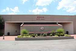
494:
479:
464:
345:
785:
420:
349:
289:
1263:
1169:
341:
178:
106:
1340:
1307:
746:
687:
1210:
1347:
1312:
1216:
691:
408:
262:
166:
110:
1291:
648:
607:
1301:
1241:
1226:
1221:
1191:
404:
1058:
1281:
979:
973:
952:
1271:
1231:
353:
1276:
709:, there were 6,569 people, 2,046 households, and 1,482 families residing in the city.
1364:
416:
294:
1033:"Geographic Identifiers: 2010 Demographic Profile Data (G001): Morrow city, Georgia"
1317:
788:
passes through the southern part of the city, with access from Exit 233 (GA 54).
1184:
161:
419:
passes through the southern part of the city, with access from Exit 233. The
390:
377:
136:
123:
243:
17:
1331:‡This populated place also has portions in an adjacent county or counties
277:
1087:. Retrieved on May 16, 2015. "5780 Jonesboro Road Morrow, Georgia 30260"
816:
804:
742:
412:
943:
810:
1080:
1251:
269:
248:
1202:
43:
1141:
781:
1250:
892:
372:
Morrow is located north of the center of
Clayton County at
326:
1035:. U.S. Census Bureau, American Factfinder. Archived from
870:
1126:
403:(33.578477, -84.340117). It is bordered to the north by
348:. Its population was 6,569 in 2020. It is the home of
1326:
1290:
1262:
1201:
895:. United States Geological Survey. October 25, 2007
321:
310:
300:
288:
276:
259:
242:
234:
226:
221:
213:
205:
197:
189:
184:
172:
160:
152:
34:
423:is in the southwest part of the city near I-75.
945:Georgia Place-Names: Their History and Origins
1153:
8:
1386:1846 establishments in Georgia (U.S. state)
823:Routes 193 and 194 connect the city to the
759:These are roads with more than four lanes.
1255:Map of Georgia highlighting Clayton County
1160:
1146:
1138:
1007:"US Gazetteer files: 2010, 2000, and 1990"
437:
31:
975:Historical Gazetteer of the United States
951:. Macon, GA: Winship Press. p. 152.
1099:"MARTA opens police precinct in Clayton"
796:In addition to a police precinct, three
589:
1381:Cities in the Atlanta metropolitan area
840:
415:is 13 miles (21 km) to the north.
320:
299:
275:
241:
220:
212:
183:
151:
116:
97:
89:
61:
49:
800:bus routes serve the city, including:
457:
813:- Justice Center/Mt. Zion/SR 42-Morel
591:Morrow racial composition as of 2020
309:
287:
258:
233:
225:
204:
196:
188:
171:
159:
7:
1391:Populated places established in 1846
912:
910:
344:, United States. It is part of the
209:0.01 sq mi (0.03 km)
201:3.38 sq mi (8.76 km)
193:3.39 sq mi (8.79 km)
1168:Municipalities and communities of
1059:"Census of Population and Housing"
972:Hellmann, Paul T. (May 13, 2013).
447:
25:
1376:Cities in Clayton County, Georgia
807:- Justice Center/SR 54/East Point
1103:The Atlanta Journal-Constitution
1081:The National Archives at Atlanta
819:- Church/Upper Riverdale/Mt.Zion
780:
741:
99:
76:
66:
51:
1127:City of Morrow official website
238:1,942.34/sq mi (749.88/km)
1371:Cities in Georgia (U.S. state)
893:"US Board on Geographic Names"
29:City in Georgia, United States
1:
873:. United States Census Bureau
851:. United States Census Bureau
718:Clayton County Public Schools
827:. Route 196 connects to the
724:National Archives at Atlanta
1011:United States Census Bureau
942:Krakow, Kenneth K. (1975).
849:"2020 U.S. Gazetteer Files"
428:United States Census Bureau
1407:
978:. Routledge. p. 240.
1336:
1248:
1182:
720:operates public schools.
707:2020 United States census
622:Black or African American
583:
568:
553:
538:
523:
508:
493:
478:
463:
456:
451:
446:
443:
346:Atlanta metropolitan area
117:
98:
90:
62:
50:
41:
407:and to the northwest by
350:Clayton State University
217:922 ft (281 m)
1171:Clayton County, Georgia
342:Clayton County, Georgia
1256:
747:Georgia State Route 54
726:is located in Morrow.
1254:
918:"Explore Census Data"
871:"U.S. Census website"
584:U.S. Decennial Census
439:Historical population
391:33.57861°N 84.34000°W
261: • Summer (
137:33.57861°N 84.34000°W
1349:United States portal
1039:on February 12, 2020
829:College Park Station
235: • Density
1013:. February 12, 2011
592:
440:
396:33.57861; -84.34000
387: /
142:33.57861; -84.34000
133: /
1257:
825:East Point Station
776:Interstate highway
590:
438:
227: • Total
206: • Water
190: • Total
1358:
1357:
1134:historical marker
1097:Simmons, Andria.
1085:National Archives
767:Southlake Parkway
703:
702:
588:
587:
426:According to the
335:
334:
198: • Land
109:and the state of
16:(Redirected from
1398:
1350:
1343:
1253:
1194:
1187:
1177:
1172:
1162:
1155:
1148:
1139:
1114:
1113:
1111:
1109:
1094:
1088:
1077:
1071:
1070:
1068:
1066:
1055:
1049:
1048:
1046:
1044:
1029:
1023:
1022:
1020:
1018:
1003:
997:
996:
994:
992:
969:
963:
962:
950:
939:
933:
932:
930:
928:
914:
905:
904:
902:
900:
889:
883:
882:
880:
878:
867:
861:
860:
858:
856:
845:
784:
749:(Jonesboro Road)
745:
662:Pacific Islander
593:
459:
454:
449:
441:
402:
401:
399:
398:
397:
392:
388:
385:
384:
383:
380:
354:Georgia Archives
331:
328:
266:
148:
147:
145:
144:
143:
138:
134:
131:
130:
129:
126:
103:
80:
70:
57:Morrow city hall
55:
32:
21:
1406:
1405:
1401:
1400:
1399:
1397:
1396:
1395:
1361:
1360:
1359:
1354:
1348:
1341:
1332:
1322:
1293:
1286:
1258:
1246:
1197:
1192:
1185:
1178:
1175:
1170:
1166:
1123:
1118:
1117:
1107:
1105:
1096:
1095:
1091:
1078:
1074:
1064:
1062:
1057:
1056:
1052:
1042:
1040:
1031:
1030:
1026:
1016:
1014:
1005:
1004:
1000:
990:
988:
986:
971:
970:
966:
959:
948:
941:
940:
936:
926:
924:
922:data.census.gov
916:
915:
908:
898:
896:
891:
890:
886:
876:
874:
869:
868:
864:
854:
852:
847:
846:
842:
837:
794:
792:Transit systems
778:
773:
757:
752:
737:
732:
715:
636:Native American
624:(non-Hispanic)
610:(non-Hispanic)
452:
436:
395:
393:
389:
386:
381:
378:
376:
374:
373:
370:
362:
325:
284:
260:
141:
139:
135:
132:
127:
124:
122:
120:
119:
113:
94:
86:
85:
84:
83:
74:
73:
58:
46:
37:
36:Morrow, Georgia
30:
23:
22:
15:
12:
11:
5:
1404:
1402:
1394:
1393:
1388:
1383:
1378:
1373:
1363:
1362:
1356:
1355:
1353:
1352:
1345:
1342:Georgia portal
1337:
1334:
1333:
1330:
1328:
1324:
1323:
1321:
1320:
1315:
1310:
1305:
1298:
1296:
1292:Unincorporated
1288:
1287:
1285:
1284:
1279:
1274:
1268:
1266:
1260:
1259:
1249:
1247:
1245:
1244:
1239:
1234:
1229:
1224:
1219:
1214:
1207:
1205:
1199:
1198:
1183:
1180:
1179:
1167:
1165:
1164:
1157:
1150:
1142:
1136:
1135:
1129:
1122:
1121:External links
1119:
1116:
1115:
1089:
1072:
1050:
1024:
998:
985:978-1135948597
984:
964:
957:
934:
906:
884:
862:
839:
838:
836:
833:
821:
820:
814:
808:
793:
790:
777:
774:
772:
771:
768:
765:
761:
756:
753:
751:
750:
738:
736:
735:State highways
733:
731:
730:Transportation
728:
714:
711:
701:
700:
697:
694:
684:
683:
680:
677:
671:
670:
667:
664:
658:
657:
654:
651:
645:
644:
641:
638:
632:
631:
628:
625:
618:
617:
614:
611:
604:
603:
600:
597:
586:
585:
581:
580:
577:
575:
572:
566:
565:
562:
560:
557:
551:
550:
547:
545:
542:
536:
535:
532:
530:
527:
521:
520:
517:
515:
512:
506:
505:
502:
500:
497:
491:
490:
487:
485:
482:
476:
475:
472:
470:
467:
461:
460:
455:
450:
445:
435:
432:
421:Southlake Mall
369:
366:
361:
358:
333:
332:
323:
319:
318:
315:
308:
307:
304:
298:
297:
292:
286:
285:
282:
280:
274:
273:
267:
257:
256:
246:
240:
239:
236:
232:
231:
228:
224:
223:
219:
218:
215:
211:
210:
207:
203:
202:
199:
195:
194:
191:
187:
186:
182:
181:
176:
170:
169:
164:
158:
157:
154:
150:
149:
115:
114:
107:Clayton County
104:
96:
95:
93:Come to Morrow
92:
88:
87:
81:
75:
71:
65:
64:
63:
60:
59:
56:
48:
47:
42:
39:
38:
35:
28:
24:
14:
13:
10:
9:
6:
4:
3:
2:
1403:
1392:
1389:
1387:
1384:
1382:
1379:
1377:
1374:
1372:
1369:
1368:
1366:
1351:
1346:
1344:
1339:
1338:
1335:
1329:
1325:
1319:
1316:
1314:
1311:
1309:
1308:Mountain View
1306:
1303:
1300:
1299:
1297:
1295:
1289:
1283:
1280:
1278:
1275:
1273:
1270:
1269:
1267:
1265:
1261:
1243:
1240:
1238:
1235:
1233:
1230:
1228:
1225:
1223:
1220:
1218:
1215:
1212:
1209:
1208:
1206:
1204:
1200:
1196:
1195:
1188:
1181:
1176:United States
1173:
1163:
1158:
1156:
1151:
1149:
1144:
1143:
1140:
1133:
1130:
1128:
1125:
1124:
1120:
1104:
1100:
1093:
1090:
1086:
1082:
1076:
1073:
1060:
1054:
1051:
1038:
1034:
1028:
1025:
1012:
1008:
1002:
999:
987:
981:
977:
976:
968:
965:
960:
958:0-915430-00-2
954:
947:
946:
938:
935:
923:
919:
913:
911:
907:
894:
888:
885:
872:
866:
863:
850:
844:
841:
834:
832:
830:
826:
818:
815:
812:
809:
806:
803:
802:
801:
799:
791:
789:
787:
786:Interstate 75
783:
775:
769:
766:
763:
762:
760:
754:
748:
744:
740:
739:
734:
729:
727:
725:
721:
719:
712:
710:
708:
698:
695:
693:
689:
686:
685:
681:
678:
676:
673:
672:
668:
665:
663:
660:
659:
655:
652:
650:
647:
646:
642:
639:
637:
634:
633:
629:
626:
623:
620:
619:
615:
612:
609:
606:
605:
601:
598:
595:
594:
582:
578:
576:
573:
571:
567:
563:
561:
558:
556:
552:
548:
546:
543:
541:
537:
533:
531:
528:
526:
522:
518:
516:
513:
511:
507:
503:
501:
498:
496:
492:
488:
486:
483:
481:
477:
473:
471:
468:
466:
462:
442:
433:
431:
429:
424:
422:
418:
417:Interstate 75
414:
410:
406:
400:
367:
365:
359:
357:
355:
351:
347:
343:
340:is a city in
339:
330:
324:
316:
313:
305:
303:
296:
293:
291:
281:
279:
271:
268:
264:
254:
253:Eastern (EST)
250:
247:
245:
237:
229:
216:
208:
200:
192:
180:
177:
175:
168:
165:
163:
156:United States
155:
146:
118:Coordinates:
112:
108:
102:
79:
69:
54:
45:
40:
33:
27:
19:
1236:
1211:College Park
1190:
1106:. Retrieved
1102:
1092:
1075:
1063:. Retrieved
1061:. Census.gov
1053:
1041:. Retrieved
1037:the original
1027:
1015:. Retrieved
1001:
991:November 30,
989:. Retrieved
974:
967:
944:
937:
927:December 13,
925:. Retrieved
921:
897:. Retrieved
887:
875:. Retrieved
865:
855:December 18,
853:. Retrieved
843:
822:
795:
779:
770:Mt Zion Road
758:
722:
716:
704:
434:Demographics
425:
371:
363:
337:
336:
327:cityofmorrow
283:30260, 30287
105:Location in
91:Motto:
26:
1313:Mundys Mill
1294:communities
1217:Forest Park
1186:County seat
899:January 31,
877:January 31,
764:Morrow Road
675:Other/Mixed
411:. Downtown
409:Forest Park
394: /
140: /
1365:Categories
1108:October 5,
835:References
755:Main roads
705:As of the
382:84°20′24″W
379:33°34′43″N
314:feature ID
222:Population
128:84°20′24″W
125:33°34′43″N
18:Morrow, GA
1327:Footnotes
1302:Ellenwood
1242:Riverdale
1227:Lake City
1222:Jonesboro
1193:Jonesboro
1017:April 23,
817:Route 196
811:Route 194
805:Route 193
713:Education
405:Lake City
368:Geography
302:FIPS code
290:Area code
278:ZIP codes
244:Time zone
214:Elevation
1282:Irondale
1043:July 28,
688:Hispanic
352:and the
306:13-53004
1272:Bonanza
1232:Lovejoy
1065:June 4,
699:15.62%
656:29.88%
630:40.05%
616:11.42%
413:Atlanta
360:History
322:Website
317:0332423
179:Clayton
167:Georgia
153:Country
111:Georgia
1277:Conley
1237:Morrow
1203:Cities
1132:Morrow
982:
955:
696:1,026
692:Latino
682:2.65%
669:0.09%
653:1,963
643:0.29%
627:2,631
602:Perc.
504:539.3%
444:Census
338:Morrow
174:County
949:(PDF)
798:MARTA
649:Asian
608:White
599:Num.
596:Race
574:6,569
564:32.0%
559:6,445
549:−5.5%
544:4,882
534:36.3%
529:5,168
514:3,791
499:3,708
489:77.9%
272:(EDT)
270:UTC-4
249:UTC-5
230:6,569
162:State
1264:CDPs
1110:2016
1067:2015
1045:2014
1019:2011
993:2013
980:ISBN
953:ISBN
929:2021
901:2008
879:2008
857:2021
679:174
613:750
579:1.9%
570:2020
555:2010
540:2000
525:1990
519:2.2%
510:1980
495:1970
480:1960
465:1950
453:Note
448:Pop.
329:.com
312:GNIS
185:Area
82:Seal
72:Flag
44:City
1318:Rex
1083:."
690:or
640:19
484:580
469:326
295:770
263:DST
1367::
1189::
1174:,
1101:.
1009:.
920:.
909:^
831:.
666:6
458:%±
356:.
1304:‡
1213:‡
1161:e
1154:t
1147:v
1112:.
1079:"
1069:.
1047:.
1021:.
995:.
961:.
931:.
903:.
881:.
859:.
474:—
265:)
255:)
251:(
20:)
Text is available under the Creative Commons Attribution-ShareAlike License. Additional terms may apply.