139:
179:
146:
172:
504:
458:). As a result, the Olympics experience high precipitation, especially during the winter months. During winter months, weather is usually cloudy, but, due to high pressure systems over the Pacific Ocean that intensify during summer months, there is often little or no cloud cover during the summer. The months June through August offer the most favorable weather for viewing or climbing this mountain.
29:
94:
792:
138:
797:
454:. As fronts approach, they are forced upward by the peaks of the Olympic Range, causing them to drop their moisture in the form of rain or snowfall (
787:
608:
171:
802:
767:
599:
739:
690:
636:
522:
431:
604:
410:
mappers Arthur
Dodwell and Theodore Rixon between 1898 and 1900. The first documented ascent of the summit was made in 1907 by
407:
262:
386:
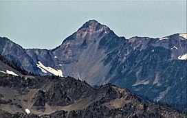
is significant as the east, west, and south aspects of the peak each rise 2,200 feet (670 m) in approximately one mile.
335:
226:
87:
703:
Peel, M. C.; Finlayson, B. L.; McMahon, T. A. (2007). "Updated world map of the Köppen−Geiger climate classification".
782:
359:
351:
347:
422:
routes to the summit have been established: via the Noyes-Meany col, the
Seattle-Noyes col, and via Low Divide.
594:
415:
403:
314:
216:
64:
54:
552:
331:
236:
77:
399:
277:
383:
339:
735:
712:
686:
632:
517:
451:
435:
395:
343:
250:
509:
455:
257:
379:
367:
243:
776:
447:
443:
439:
411:
363:
300:
470:
375:
307:
294:
489:
371:
355:
69:
649:
499:
419:
716:
109:
96:
481:
477:
467:
378:, and south into headwaters of Seattle Creek which is a tributary of the
669:
Gods and
Goblins: A Field Guide to Place Names of Olympic National Park
28:
629:
The Land That Slept Late: The
Olympic Mountains in Legend and History
567:
492:
era by erosion and glaciers advancing and retreating multiple times.
485:
474:
374:, west into headwaters of Saghalie Creek which is a tributary of the
327:
282:
44:
406:. It is possible that the mountain may have been climbed by
370:
from the mountain draining east into the headwaters of the
759:
488:
oceanic crust. The mountains were sculpted during the
346:, Mount Noyes is situated seven miles southeast of
306:
293:
288:
276:
271:
256:
242:
232:
222:
212:
204:
125:
86:
76:
63:
53:
43:
38:
21:
362:rises one mile to the southeast. Noyes is a major
562:
560:
418:first ascent attempt at Mount Olympus. Three
358:, 0.6 miles (0.97 km) to the north, and
16:Mountain in Washington (state), United States
8:
473:wedge material and oceanic crust, primarily
414:and Grant Humes who were reconnoitering for
394:The mountain was named during the 1889-90
18:
793:Mountains of Jefferson County, Washington
685:, 4th Edition, 2006, Mountaineers Books,
609:United States Department of the Interior
326:is a 6,173-foot (1,882 m) mountain
534:
589:
587:
466:The Olympic Mountains are composed of
553:climbersguideolympics.com Mount Noyes
548:
546:
544:
542:
540:
538:
158:Location of Mount Noyes in Washington
7:
683:Olympic Mountains: A Climbing Guide
600:Geographic Names Information System
178:
145:
798:Landforms of Olympic National Park
450:, and travel northeast toward the
402:(1825-1908), the publisher of the
14:
730:Alt, D.D.; Hyndman, D.W. (1984).
354:. The nearest higher neighbor is
523:Geology of the Pacific Northwest
502:
434:, Mount Noyes is located in the
177:
170:
144:
137:
27:
788:Mountains of Washington (state)
605:United States Geological Survey
191:Mount Noyes (the United States)
732:Roadside Geology of Washington
161:Show map of Washington (state)
1:
803:North American 1000 m summits
432:Köppen climate classification
194:Show map of the United States
49:6,173 ft (1,882 m)
82:0.78 mi (1.26 km)
819:
568:"Noyes, Mount - 6,173' WA"
352:Daniel J. Evans Wilderness
110:47.7397396°N 123.5948252°W
681:Olympic Mountain Rescue,
650:"Mount Noyes, Washington"
366:point with precipitation
130:
26:
762:. National Park Service.
667:Parratt, Smitty (1984).
438:climate zone of western
396:Seattle Press Expedition
115:47.7397396; -123.5948252
59:373 ft (114 m)
760:"Olympic National Park"
705:Hydrol. Earth Syst. Sci
404:Washington Evening Star
631:, Mountaineers Books,
627:Robert L. Wood, 1995,
350:, and set within the
332:Olympic National Park
237:Olympic National Park
734:. pp. 249–259.
330:located deep within
400:Crosby Stuart Noyes
342:state. Part of the
317:via Noyes-Meany col
233:Protected area
106: /
766:Weather forecast:
384:Topographic relief
39:Highest point
783:Olympic Mountains
518:Olympic Mountains
452:Olympic Mountains
446:originate in the
436:marine west coast
344:Olympic Mountains
321:
320:
251:Olympic Mountains
810:
763:
746:
745:
727:
721:
720:
700:
694:
679:
673:
672:
664:
658:
657:
646:
640:
625:
619:
618:
616:
615:
591:
582:
581:
579:
578:
564:
555:
550:
512:
510:Mountains portal
507:
506:
505:
416:The Mountaineers
336:Jefferson County
310:
246:
195:
181:
180:
174:
162:
148:
147:
141:
121:
120:
118:
117:
116:
111:
107:
104:
103:
102:
99:
31:
19:
818:
817:
813:
812:
811:
809:
808:
807:
773:
772:
758:
755:
750:
749:
742:
729:
728:
724:
702:
701:
697:
680:
676:
671:(1st ed.).
666:
665:
661:
648:
647:
643:
626:
622:
613:
611:
593:
592:
585:
576:
574:
572:listsofjohn.com
566:
565:
558:
551:
536:
531:
508:
503:
501:
498:
464:
456:Orographic lift
428:
392:
308:
244:
200:
199:
198:
197:
196:
193:
192:
189:
188:
187:
186:
182:
165:
164:
163:
160:
159:
156:
155:
154:
153:
149:
114:
112:
108:
105:
100:
97:
95:
93:
92:
34:
17:
12:
11:
5:
816:
814:
806:
805:
800:
795:
790:
785:
775:
774:
771:
770:
764:
754:
753:External links
751:
748:
747:
740:
722:
695:
674:
659:
654:Peakbagger.com
641:
620:
583:
556:
533:
532:
530:
527:
526:
525:
520:
514:
513:
497:
494:
463:
460:
444:weather fronts
427:
424:
391:
388:
380:Quinault River
319:
318:
312:
304:
303:
297:
291:
290:
286:
285:
280:
274:
273:
269:
268:
266:Mount Christie
260:
254:
253:
248:
240:
239:
234:
230:
229:
224:
220:
219:
214:
210:
209:
206:
202:
201:
190:
184:
183:
176:
175:
169:
168:
167:
166:
157:
151:
150:
143:
142:
136:
135:
134:
133:
132:
131:
128:
127:
123:
122:
90:
84:
83:
80:
74:
73:
67:
61:
60:
57:
51:
50:
47:
41:
40:
36:
35:
32:
24:
23:
15:
13:
10:
9:
6:
4:
3:
2:
815:
804:
801:
799:
796:
794:
791:
789:
786:
784:
781:
780:
778:
769:
765:
761:
757:
756:
752:
743:
741:0-87842-160-2
737:
733:
726:
723:
718:
714:
711:: 1633–1644.
710:
706:
699:
696:
692:
691:9780898862065
688:
684:
678:
675:
670:
663:
660:
655:
651:
645:
642:
638:
637:9780898864403
634:
630:
624:
621:
610:
606:
602:
601:
596:
595:"Mount Noyes"
590:
588:
584:
573:
569:
563:
561:
557:
554:
549:
547:
545:
543:
541:
539:
535:
528:
524:
521:
519:
516:
515:
511:
500:
495:
493:
491:
487:
483:
479:
476:
472:
469:
461:
459:
457:
453:
449:
448:Pacific Ocean
445:
441:
440:North America
437:
433:
430:Based on the
425:
423:
421:
417:
413:
412:Asahel Curtis
409:
405:
401:
397:
389:
387:
385:
381:
377:
373:
369:
365:
364:triple divide
361:
360:Mount Seattle
357:
353:
349:
348:Mount Olympus
345:
341:
337:
333:
329:
325:
316:
315:class 2+
313:
311:
309:Easiest route
305:
302:
301:Asahel Curtis
298:
296:
292:
287:
284:
281:
279:
275:
270:
267:
264:
261:
259:
255:
252:
249:
247:
241:
238:
235:
231:
228:
225:
221:
218:
215:
211:
208:United States
207:
203:
173:
140:
129:
124:
119:
91:
89:
85:
81:
79:
75:
71:
68:
66:
62:
58:
56:
52:
48:
46:
42:
37:
30:
25:
20:
731:
725:
708:
704:
698:
682:
677:
668:
662:
653:
644:
628:
623:
612:. Retrieved
598:
575:. Retrieved
571:
465:
429:
393:
376:Queets River
323:
322:
299:May 1907 by
295:First ascent
265:
245:Parent range
768:Mount Noyes
639:, page 131.
490:Pleistocene
372:Elwha River
356:Mount Meany
324:Mount Noyes
278:Age of rock
185:Mount Noyes
152:Mount Noyes
113: /
101:123°35′41″W
88:Coordinates
70:Mount Meany
65:Parent peak
33:East aspect
22:Mount Noyes
777:Categories
693:, page 24.
614:2022-01-03
577:2022-01-03
529:References
340:Washington
217:Washington
98:47°44′23″N
72:(6,695 ft)
55:Prominence
717:1027-5606
482:turbidite
478:sandstone
398:to honor
227:Jefferson
126:Geography
78:Isolation
45:Elevation
496:See also
486:basaltic
468:obducted
420:scramble
289:Climbing
258:Topo map
471:clastic
462:Geology
442:. Most
426:Climate
390:History
272:Geology
205:Country
738:
715:
689:
635:
484:, and
475:Eocene
368:runoff
328:summit
283:Eocene
223:County
213:State
736:ISBN
713:ISSN
687:ISBN
633:ISBN
408:USGS
263:USGS
338:of
334:in
779::
709:11
707:.
652:.
607:,
603:.
597:.
586:^
570:.
559:^
537:^
480:,
382:.
744:.
719:.
656:.
617:.
580:.
Text is available under the Creative Commons Attribution-ShareAlike License. Additional terms may apply.