151:
158:
36:
340:
331:
of life, and even today some of these unique species have proven impossible to classify. The fossils are especially valuable because they include appendages and soft parts that are rarely preserved. At 508 million years
293:
It was named in 1886 by astronomer Otto Klotz after
Alexander MacKinnon Burgess, the Deputy Minister of the Interior at the time when Klotz worked for a railway construction.
150:
574:
107:
650:
655:
93:
558:
529:
520:
404:
214:
394:
660:
41:
80:
620:
100:
211:
327:) named after nearby Burgess Pass, in which are found new and unique species, many in fact constituting entire new
645:
308:
301:
217:
374:
185:
75:
65:
497:
550:
362:
282:
266:
88:
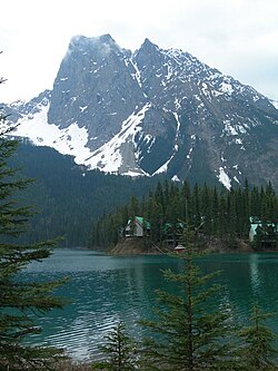
354:
Between 1954 and 1971, Mount
Burgess was featured on the back of the Canadian ten-dollar bill.
300:
was the first to ascend this mountain. He was completing a survey of the lands adjacent to the
554:
525:
400:
297:
235:
274:
170:
351:
The mountain has two summits. The lower north summit was named
Walcott Peak in his honour.
270:
206:
199:
35:
339:
344:
324:
192:
639:
410:
312:
278:
492:
243:
229:
17:
320:
465:
250:
628:
122:
109:
336:) old, it is one of the earliest fossil beds containing soft-part imprints.
436:
262:
333:
595:
399:(Map). 1:50,000. Cochrane, AB: Gem Trek Publishing. 2001. § C2.
358:
328:
316:
55:
549:. With the collaboration of Putnam, William Lowell (6th ed.).
545:
Thorington, J. Monroe (1966) . "Kicking Horse Pass to Howse Pass".
338:
277:. It is located in the southwest buttress of Burgess Pass in the
343:
Reverse of ten-dollar bill showing Mount
Burgess (courtesy
319:
with fine details on Mount
Burgess. The Burgess Shale is a
524:. Calgary: Rocky Mountain Books. pp. 260–261.
242:
228:
223:
205:
191:
181:
138:
99:
87:
74:
64:
54:
49:
28:
547:A Climber's Guide to the Rocky Mountains of Canada
8:
25:
460:
458:
456:
487:
485:
386:
431:
429:
427:
575:"1954: The Canadian Landscape Series"
157:
7:
518:Kane, Alan (1999). "Mount Burgess".
651:Two-thousanders of British Columbia
261:2,599 m (8,527 ft), is a
14:
521:Scrambles in the Canadian Rockies
156:
149:
34:
656:Mountains of Yoho National Park
596:"Canadian Rocky Mountain Parks"
23:Mountain in Yoho NP, BC, Canada
1:
94:Mountains of British Columbia
40:Mount Burgess background and
60:2,599 m (8,527 ft)
677:
70:418 m (1,371 ft)
15:
143:
33:
302:Canadian Pacific Railway
171:British Columbia, Canada
16:Not to be confused with
577:. Bank of Canada Museum
375:Field, British Columbia
661:Kootenay Land District
441:cdnrockiesdatabases.ca
396:Lake Louise & Yoho
348:
186:Kootenay Land District
123:51.42000°N 116.50528°W
20:, a town in Australia.
498:BC Geographical Names
342:
551:American Alpine Club
361:declared the area a
128:51.42000; -116.50528
363:World Heritage Site
307:In 1909, geologist
283:Kicking Horse River
269:and is part of the
119: /
349:
309:Charles D. Walcott
267:Yoho National Park
50:Highest point
298:James J. McArthur
256:
255:
236:James J. McArthur
668:
646:Canadian Rockies
632:
627:. Archived from
607:
606:
604:
603:
592:
586:
585:
583:
582:
571:
565:
564:
542:
536:
535:
515:
509:
508:
506:
505:
489:
480:
479:
477:
476:
462:
451:
450:
448:
447:
433:
422:
421:
419:
418:
409:. Archived from
391:
275:Canadian Rockies
246:
195:
160:
159:
153:
134:
133:
131:
130:
129:
124:
120:
117:
116:
115:
112:
38:
26:
676:
675:
671:
670:
669:
667:
666:
665:
636:
635:
621:"Mount Burgess"
619:
616:
611:
610:
601:
599:
594:
593:
589:
580:
578:
573:
572:
568:
561:
553:. p. 139.
544:
543:
539:
532:
517:
516:
512:
503:
501:
493:"Mount Burgess"
491:
490:
483:
474:
472:
466:"Mount Burgess"
464:
463:
454:
445:
443:
437:"Mount Burgess"
435:
434:
425:
416:
414:
407:
393:
392:
388:
383:
371:
334:middle Cambrian
311:discovered the
291:
271:President Range
244:
200:President Range
193:
177:
176:
175:
174:
173:
168:
167:
166:
165:
161:
127:
125:
121:
118:
113:
110:
108:
106:
105:
45:
24:
21:
12:
11:
5:
674:
672:
664:
663:
658:
653:
648:
638:
637:
634:
633:
631:on 2016-03-04.
615:
614:External links
612:
609:
608:
587:
566:
560:978-1376169003
559:
537:
530:
510:
481:
452:
423:
405:
385:
384:
382:
379:
378:
377:
370:
367:
345:Bank of Canada
290:
287:
259:Mount Burgess,
254:
253:
248:
240:
239:
232:
226:
225:
221:
220:
209:
203:
202:
197:
189:
188:
183:
179:
178:
169:
163:
162:
155:
154:
148:
147:
146:
145:
144:
141:
140:
136:
135:
103:
97:
96:
91:
85:
84:
78:
72:
71:
68:
62:
61:
58:
52:
51:
47:
46:
39:
31:
30:
22:
13:
10:
9:
6:
4:
3:
2:
673:
662:
659:
657:
654:
652:
649:
647:
644:
643:
641:
630:
626:
622:
618:
617:
613:
597:
591:
588:
576:
570:
567:
562:
556:
552:
548:
541:
538:
533:
531:0-921102-67-4
527:
523:
522:
514:
511:
500:
499:
494:
488:
486:
482:
471:
467:
461:
459:
457:
453:
442:
438:
432:
430:
428:
424:
413:on 2019-06-09
412:
408:
406:1-895526-15-9
402:
398:
397:
390:
387:
380:
376:
373:
372:
368:
366:
364:
360:
355:
352:
346:
341:
337:
335:
330:
326:
322:
318:
314:
313:Burgess Shale
310:
305:
303:
299:
294:
288:
286:
284:
280:
279:Emerald River
276:
272:
268:
264:
260:
252:
249:
247:
245:Easiest route
241:
237:
233:
231:
227:
222:
219:
216:
213:
210:
208:
204:
201:
198:
196:
190:
187:
184:
180:
172:
164:Mount Burgess
152:
142:
137:
132:
104:
102:
98:
95:
92:
90:
86:
83:(2642 m)
82:
79:
77:
73:
69:
67:
63:
59:
57:
53:
48:
43:
37:
32:
29:Mount Burgess
27:
19:
629:the original
625:Peakware.com
624:
600:. Retrieved
590:
579:. Retrieved
569:
546:
540:
519:
513:
502:. Retrieved
496:
473:. Retrieved
469:
444:. Retrieved
440:
415:. Retrieved
411:the original
395:
389:
356:
353:
350:
323:fossil bed (
306:
295:
292:
258:
257:
230:First ascent
194:Parent range
42:Emerald Lake
18:Mount Burges
470:Bivouac.com
325:Lagerstätte
321:black shale
315:deposit of
238:and H. Tuzo
126: /
114:116°30′19″W
101:Coordinates
81:Mount Field
76:Parent peak
640:Categories
602:2019-10-09
581:2019-10-09
504:2010-11-13
475:2008-12-22
446:2019-08-20
417:2019-09-07
381:References
111:51°25′12″N
66:Prominence
44:foreground
357:In 1984,
296:In 1892,
285:Valleys.
139:Geography
56:Elevation
598:. UNESCO
369:See also
263:mountain
251:Scramble
234:1892 by
224:Climbing
207:Topo map
182:District
317:fossils
289:History
273:in the
89:Listing
557:
528:
403:
359:UNESCO
218:Golden
329:phyla
555:ISBN
526:ISBN
401:ISBN
281:and
215:82N7
265:in
212:NTS
642::
623:.
495:.
484:^
468:.
455:^
439:.
426:^
365:.
304:.
605:.
584:.
563:.
534:.
507:.
478:.
449:.
420:.
347:)
332:(
Text is available under the Creative Commons Attribution-ShareAlike License. Additional terms may apply.