141:
148:
572:
542:, perhaps due to the long walk-in times and access difficulties. So far, local climbers have generally agreed that the peak should remain "traditional only" (no bolts). The spectacular East Face was first climbed in 1966, and over the years a number of other routes have been put up in the vicinity of Leaning Peak and Isolated Peak. More recently, bouldering (ground-level climbing) has become popular in Mount Barney Creek upstream from the Lower Portals camping area.
558:
509:
828:
53:
517:
walkers. Whilst the steep route up Logan's Ridge to the East Peak summit is often considered to be the most spectacular, all the routes have their attractions. As a rough guide, a trip to East Peak via one of the more direct routes will generally take 8–9 hours return when carrying a day pack. There is usually a flow of
516:
There are a dozen or so established bushwalking routes up Mount Barney, however none of them are easy. All the routes require a reasonable level of fitness, and many require advanced route-finding and rock-scrambling skills. Only South Ridge ("Peasants Ridge") can be recommended to less experienced
478:
Historical records suggest that
Europeans probably began bushwalking at Mount Barney for recreation in about the 1880s, when the region became more closely settled. During the first decade or so of the 20th century, the peak became popular with a small number of self-styled 'mountaineers', such as
487:
Technical
College Principal R.A. Wearne (1870–1932), and some of the selectors who lived close by, such as the Doherty family at 'Lilydale'. However it was probably not until the early 1930s, with the formation of groups such as the National Parks Association, and the appearance of a new breed of
521:
in the creek at the saddle between East and West Peak, but elsewhere on the mountain, away from the creeks, water is often difficult to find. In addition to the mountain itself, Mount Barney Creek (to the West) and Cronan's Creek (to the South-East), the two main creek systems which ring Mount
529:
There are a few Class 4 hiking trails around the base of the mountain, including the Lower
Portals, and Cronan Creek Trails. A free iPhone GPS App is available to aid hikers in keeping to hiking trails within Mt Barney National Park.
420:
Mount Barney has held a special significance for local
Aboriginal people for millennia, and it features prominently in a number of their stories. For Aboriginal people the peak has traditionally been regarded as a place to avoid.
266:
South (Peasants) Ridge, Mezzanine Ridge, Lions Ridge, South East Ridge, Mid South East Ridge, Logans Ridge, Rocky Creek, North Ridge, Northeast Ridge, Eagles Ridge, Short
Leaning Route, Long Leaning Route, Midgets Route, Savages
488:
outdoor adventurers such as Bert Salmon (1899–1982), who made the first recorded ascent of
Leaning Peak in 1932, Cliff Wilson (who was probably the first European to climb all of the Mount Barney peaks and lesser pinnacles) and
496:(1890–1950) and Lindsay Smith (1917–1970), that bushwalkers began visiting the peak in numbers, and even then, much of Mount Barney remained unexplored until the late 1940s and early 1950s, when groups such as the
545:
There is one multipitch sport climb known as “The
Governor”. At 320 metres (1,050 ft) long, it is one of Queensland's longest climbs. The longest is the 410 metre North Face of Leaning Peak climbed in 1968.
698:
765:
See
Grenville Kingsley's account of an ascent of Mount Barney made by R.M. Collins and other locals in 1886 - 'A Trip Up Mount Barney', Brisbane Courier, 10 November 1886, p.7. View on-line at
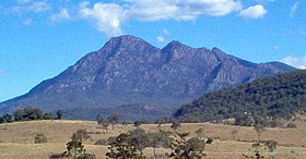
311:. The mountain consists of two main peaks, (East Peak and the slightly higher West Peak), and smaller subsidiary peaks. East Peak is probably the most popular destination for bushwalkers.
97:
615:
140:
706:
467:, who reached the East Peak summit via the now named Logan's Ridge, during an exploring expedition in 1828. Accounts of the climb were written by botanists
853:
307:
and campers. Mount Barney is the sixth or seventh highest mountain in
Queensland and is often regarded as one of the most impressive parts of the
385:
786:
754:
660:
522:
Barney, offer plenty of scope for walking and camping, particularly in the warmer months. Note though that the creeks are prone to
728:
489:
590:
585:
187:
West Peak (1359), East Peak (1354), North
Pinnacle (1221), Leaning Peak, Isolated Peak, Toms Tum, Midget Peak, Barrabool Peak
83:
90:
472:
425:
335:
858:
449:
433:
381:
468:
500:
Bushwalking Club, and the Brisbane Bushwalkers began making regular bushwalking and camping trips to the peak.
497:
33:
832:
315:
221:
370:
623:
362:
285:
838:
405:
384:
was established to protect the natural heritage surrounding the peak. Mount Barney was included in the
798:
493:
484:
409:
369:
covered much of South East Queensland and North East New South Wales with lavas referred to as the
211:
37:
327:
319:
480:
78:
36:. For the mountain formerly called Mount Barney, located near Tenterfield, New South Wales, see
323:
782:
750:
676:
656:
563:
389:
281:
577:
526:
after heavy rainfall, and that they are potentially quite dangerous at times of high flow.
300:
199:
518:
192:
847:
539:
464:
441:
366:
242:
408:. Heath vegetation on the mountain provides habitat for a colony of the endangered
401:
331:
261:
249:
236:
523:
339:
396:
of nearby Mount Ballow. Important animal species found on the mountain include
553:
393:
351:
308:
304:
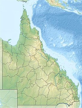
299:, not far from the Queensland - New South Wales border, and forms part of the
288:
173:
358:. Erosion has stripped away the sandstone leaving the mountain's twin peaks.
112:
99:
766:
508:
355:
354:
that formed below the surface and subsequently intruded into the overlaying
292:
177:
17:
827:
679:. Department of National Parks, Recreation, Sport and Racing. 11 July 2013
483:
school teachers Harry Johns (1877–1943) and William Gaylard (1880–1930),
397:
392:
can be found of the upper slopes of adjacent Mount Nothafagus and in the
296:
277:
538:
To date, Mount Barney has attracted only a relatively small number of
444:, a colonial engineer. Mitchell is believed to have assigned the name
460:
68:
52:
295:. It lies approximately 130 kilometres (81 mi) south-west of
507:
705:. The State of Queensland. 3 September 2009. Archived from
361:
Mount Barney is the remnants of the central complex of the
318:. Mount Barney is surrounded by other mountains including
677:"Mount Barney National Park: Nature, culture and history"
651:
Environmental Protection Agency (Queensland) (2000).
32:"Mount Barney" redirects here. For the locality, see
260:
248:
235:
230:
220:
210:
205:
191:
183:
169:
128:
89:
77:
67:
62:
45:
799:"The Governor, 320m Sport climb in Mt Barney"
839:Northern Rivers Geology Blog - Focal Peak Volcano
703:Department of Environment and Resource Management
747:Explorers of the Moreton Bay District, 1770-1830
475:, who accompanied Logan for part of the ascent.
432:. However, the New South Wales Surveyor-General
436:is believed to have renamed it in the 1840s to
8:
646:
644:
642:
640:
42:
767:http://nla.gov.au/nla.news-article4486604
492:(1904–1953), and also botanists such as
653:Heritage Trails of the Great South East
616:"Mount Barney – mountain (entry 40972)"
602:
452:(which Cunningham had originally named
610:
608:
606:
7:
350:The dome-shaped mass is composed of
342:has its headwaters on the mountain.
147:
655:. State of Queensland. p. 32.
386:Central Eastern Rainforest Reserves
854:Mountains of South East Queensland
463:to climb Mount Barney was Captain
303:. It is a popular destination for
25:
27:Mountain in Queensland, Australia
826:
781:. pp 55 - 74. Rankin Publishers
570:
556:
146:
139:
51:
591:List of volcanoes in Australia
586:List of mountains in Australia
1:
256:Peasants Ridge (South Ridge)
73:1,359 m (4,459 ft)
424:On 3 August 1828, explorer
875:
382:Mount Barney National Park
31:
779:Secrets of the Scenic Rim
241:3 August 1828 by Captain
133:
50:
498:University of Queensland
365:which together with the
34:Mount Barney, Queensland
777:Rankin, Robert. (1992)
749:, St Lucia, UQ Press -
729:"Mount Barneys Legend"
620:Queensland Place Names
513:
160:Location in Queensland
84:Mountains in Australia
745:Steele, J.G., (1972)
699:"Eastern Bristlebird"
624:Queensland Government
511:
216:24 million years
835:at Wikimedia Commons
314:The closest town is
735:. 19 November 1932.
428:named the mountain
410:eastern bristlebird
371:Lamington Volcanics
109: /
709:on 5 November 2009
514:
512:Mount Barney, 2011
406:Coxen's fig parrot
363:Focal Peak Volcano
113:28.283°S 152.700°E
63:Highest point
859:Scenic Rim Region
831:Media related to
564:Queensland portal
282:Scenic Rim Region
271:
270:
16:(Redirected from
866:
830:
814:
813:
811:
809:
795:
789:
775:
769:
763:
757:
743:
737:
736:
733:Brisbane Courier
725:
719:
718:
716:
714:
695:
689:
688:
686:
684:
673:
667:
666:
648:
635:
634:
632:
630:
612:
580:
578:Mountains portal
575:
574:
573:
566:
561:
560:
559:
473:Allan Cunningham
426:Allan Cunningham
376:Natural heritage
252:
195:
150:
149:
143:
124:
123:
121:
120:
119:
118:-28.283; 152.700
114:
110:
107:
106:
105:
102:
55:
43:
21:
874:
873:
869:
868:
867:
865:
864:
863:
844:
843:
823:
818:
817:
807:
805:
797:
796:
792:
776:
772:
764:
760:
744:
740:
727:
726:
722:
712:
710:
697:
696:
692:
682:
680:
675:
674:
670:
663:
650:
649:
638:
628:
626:
614:
613:
604:
599:
576:
571:
569:
562:
557:
555:
552:
536:
519:drinkable water
506:
448:to the current
434:Thomas Mitchell
418:
390:Antarctic beech
378:
348:
301:McPherson Range
250:
200:McPherson Range
193:
165:
164:
163:
162:
161:
158:
157:
156:
155:
151:
117:
115:
111:
108:
103:
100:
98:
96:
95:
58:
41:
28:
23:
22:
15:
12:
11:
5:
872:
870:
862:
861:
856:
846:
845:
842:
841:
836:
822:
821:External links
819:
816:
815:
790:
770:
758:
738:
720:
690:
668:
661:
636:
601:
600:
598:
595:
594:
593:
588:
582:
581:
567:
551:
548:
535:
532:
524:flash flooding
505:
502:
469:Charles Fraser
450:Mount Lindesay
446:Mount Lindesay
430:Mount Lindesay
417:
414:
402:rock wallabies
377:
374:
347:
344:
336:Mount Lindesay
269:
268:
264:
258:
257:
254:
246:
245:
239:
233:
232:
228:
227:
226:Shield volcano
224:
218:
217:
214:
208:
207:
203:
202:
197:
189:
188:
185:
181:
180:
171:
167:
166:
159:
153:
152:
145:
144:
138:
137:
136:
135:
134:
131:
130:
126:
125:
93:
87:
86:
81:
75:
74:
71:
65:
64:
60:
59:
56:
48:
47:
26:
24:
14:
13:
10:
9:
6:
4:
3:
2:
871:
860:
857:
855:
852:
851:
849:
840:
837:
834:
829:
825:
824:
820:
804:
800:
794:
791:
788:
787:0-9592418-3-3
784:
780:
774:
771:
768:
762:
759:
756:
755:0-7022-1655-0
752:
748:
742:
739:
734:
730:
724:
721:
708:
704:
700:
694:
691:
678:
672:
669:
664:
662:0-7345-1008-X
658:
654:
647:
645:
643:
641:
637:
625:
621:
617:
611:
609:
607:
603:
596:
592:
589:
587:
584:
583:
579:
568:
565:
554:
549:
547:
543:
541:
540:rock climbers
534:Rock climbing
533:
531:
527:
525:
520:
510:
503:
501:
499:
495:
491:
486:
482:
476:
474:
470:
466:
465:Patrick Logan
462:
457:
455:
451:
447:
443:
442:George Barney
439:
435:
431:
427:
422:
415:
413:
411:
407:
403:
399:
395:
391:
388:in 1994. The
387:
383:
380:In 1947, the
375:
373:
372:
368:
367:Tweed Volcano
364:
359:
357:
353:
345:
343:
341:
337:
333:
329:
325:
321:
317:
312:
310:
306:
302:
298:
294:
290:
287:
283:
279:
275:
265:
263:
259:
255:
253:
251:Easiest route
247:
244:
243:Patrick Logan
240:
238:
234:
229:
225:
223:
222:Mountain type
219:
215:
213:
209:
204:
201:
198:
196:
190:
186:
182:
179:
175:
172:
168:
142:
132:
127:
122:
94:
92:
88:
85:
82:
80:
76:
72:
70:
66:
61:
54:
49:
44:
39:
38:Mount Mcmahon
35:
30:
19:
833:Mount Barney
806:. Retrieved
802:
793:
778:
773:
761:
746:
741:
732:
723:
711:. Retrieved
707:the original
702:
693:
681:. Retrieved
671:
652:
627:. Retrieved
619:
544:
537:
528:
515:
490:Arthur Groom
477:
458:
454:Mount Hooker
453:
445:
438:Mount Barney
437:
429:
423:
419:
379:
360:
349:
332:Mount Maroon
328:Mount Ernest
320:Mount Ballow
313:
274:Mount Barney
273:
272:
262:Normal route
237:First ascent
194:Parent range
154:Mount Barney
57:Mount Barney
46:Mount Barney
29:
18:Mount Barney
808:1 September
713:23 December
629:18 February
504:Bushwalking
494:Cyril White
340:Logan River
305:bushwalkers
280:within the
212:Age of rock
116: /
91:Coordinates
848:Categories
597:References
459:The first
394:rainforest
352:granophyre
316:Rathdowney
309:Scenic Rim
289:Queensland
286:south-east
174:Queensland
356:sandstone
324:Mount May
293:Australia
178:Australia
129:Geography
69:Elevation
683:7 August
550:See also
461:European
440:, after
398:platypus
297:Brisbane
278:mountain
231:Climbing
170:Location
104:152°42′E
803:theCrag
485:Ipswich
416:History
346:Geology
206:Geology
101:28°17′S
79:Listing
785:
753:
659:
481:Boonah
276:is a
267:Ridge
184:Peaks
810:2019
783:ISBN
751:ISBN
715:2009
685:2013
657:ISBN
631:2014
471:and
404:and
334:and
456:).
284:in
850::
801:.
731:.
701:.
639:^
622:.
618:.
605:^
412:.
400:,
338:.
330:,
326:,
322:,
291:,
176:,
812:.
717:.
687:.
665:.
633:.
40:.
20:)
Text is available under the Creative Commons Attribution-ShareAlike License. Additional terms may apply.