295:
142:
595:
135:
583:
29:
571:
275:
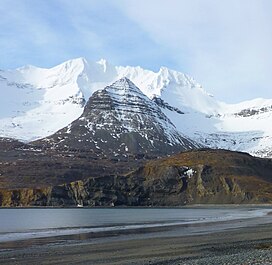
is significant as the summit rises over 3,000 feet (914 meters) above tidewater at
Kanatak Lagoon in 1.2 miles (1.9 km). The mountain's name was published in the 1880s by the
625:
91:
323:), causing heavy precipitation in the form of rainfall and snowfall. Winter temperatures can drop to 0 °F with wind chill factors below −10 °F.
503:
427:
280:
276:
554:
494:
418:
294:
134:
264:
195:
332:
308:
499:
423:
221:
561:
615:
84:
523:
Peel, M. C.; Finlayson, B. L.; McMahon, T. A. (2007). "Updated world map of the Köppen−Geiger climate classification".
489:
413:
620:
64:
54:
185:
74:
291:
after the
Russian navigator Dmitry Bocharov of the Imperial Russian Navy who explored Kodiak in 1788.
337:
288:
272:
532:
599:
575:
260:
263:. It is set on the west shore of Portage Bay and north shore of Kanatak Lagoon, within the
320:
312:
216:
268:
256:
252:
209:
202:
609:
587:
316:
284:
357:
452:
315:
zone with cold, snowy winters, and cool summers. Weather systems coming off the
271:
from the mountain drains into
Kanatak Creek, Portage Bay, and Kanatak Lagoon.
536:
106:
93:
28:
382:
240:
236:
175:
44:
255:, Mount Becharof is located 135 miles (217 km) west of
559:
283:. The mountain is named in association with nearby
279:and the toponym has been officially adopted by the
215:
201:
191:
181:
171:
163:
122:
83:
73:
63:
53:
43:
38:
21:
479:, U.S. Government Printing Office, 1967, page 120.
235:is a 3,146-foot-elevation (959-meter) mountain
377:
375:
373:
8:
447:
445:
443:
626:Mountains of Kodiak Island Borough, Alaska
18:
504:United States Department of the Interior
428:United States Department of the Interior
293:
566:
349:
311:system, Mount Becharof is located in a
281:United States Board on Geographic Names
277:United States Coast and Geodetic Survey
408:
406:
404:
402:
141:
319:are forced upwards by the mountains (
7:
495:Geographic Names Information System
419:Geographic Names Information System
14:
265:Becharof National Wildlife Refuge
259:on the southeastern coast of the
196:Becharof National Wildlife Refuge
16:Mountain in Alaska, United States
593:
581:
569:
477:Dictionary of Alaska Place Names
333:List of mountain peaks of Alaska
140:
133:
27:
500:United States Geological Survey
424:United States Geological Survey
358:"Mount Becharof, Peakvisor.com"
1:
383:"Becharof, Mount - 3,150' AK"
309:Köppen climate classification
79:17.88 mi (28.78 km)
287:which was named in 1868 by
642:
107:57.5438461°N 156.0790267°W
59:2,575 ft (785 m)
49:3,146 ft (959 m)
127:
26:
453:"Mount Becharof, Alaska"
313:subpolar oceanic climate
112:57.5438461; -156.0790267
69:Deer Mountain (3,350 ft)
525:Hydrol. Earth Syst. Sci
298:Mount Becharof in 1940s
299:
297:
186:Kodiak Island Borough
616:Mountains of Alaska
338:Geography of Alaska
289:William Healey Dall
192:Protected area
103: /
300:
273:Topographic relief
154:Location in Alaska
39:Highest point
307:According to the
230:
229:
633:
598:
597:
596:
586:
585:
584:
574:
573:
572:
565:
555:weather forecast
553:Mount Becharof:
541:
540:
520:
514:
513:
511:
510:
486:
480:
475:Donald J. Orth,
473:
467:
466:
464:
463:
449:
438:
437:
435:
434:
414:"Mount Becharof"
410:
397:
396:
394:
393:
379:
368:
367:
365:
364:
354:
267:. Precipitation
261:Alaska Peninsula
205:
144:
143:
137:
118:
117:
115:
114:
113:
108:
104:
101:
100:
99:
96:
33:Northeast aspect
31:
19:
641:
640:
636:
635:
634:
632:
631:
630:
606:
605:
604:
594:
592:
582:
580:
570:
568:
560:
550:
545:
544:
522:
521:
517:
508:
506:
490:"Becharof Lake"
488:
487:
483:
474:
470:
461:
459:
451:
450:
441:
432:
430:
412:
411:
400:
391:
389:
387:listsofjohn.com
381:
380:
371:
362:
360:
356:
355:
351:
346:
329:
321:orographic lift
305:
249:
203:
159:
158:
157:
156:
155:
152:
151:
150:
149:
145:
111:
109:
105:
102:
97:
94:
92:
90:
89:
34:
17:
12:
11:
5:
639:
637:
629:
628:
623:
621:Aleutian Range
618:
608:
607:
603:
602:
590:
578:
558:
557:
549:
548:External links
546:
543:
542:
515:
481:
468:
457:Peakbagger.com
439:
398:
369:
348:
347:
345:
342:
341:
340:
335:
328:
325:
304:
301:
253:Aleutian Range
248:
245:
233:Mount Becharof
228:
227:
219:
213:
212:
210:Aleutian Range
207:
199:
198:
193:
189:
188:
183:
179:
178:
173:
169:
168:
165:
161:
160:
153:
148:Mount Becharof
147:
146:
139:
138:
132:
131:
130:
129:
128:
125:
124:
120:
119:
87:
81:
80:
77:
71:
70:
67:
61:
60:
57:
51:
50:
47:
41:
40:
36:
35:
32:
24:
23:
22:Mount Becharof
15:
13:
10:
9:
6:
4:
3:
2:
638:
627:
624:
622:
619:
617:
614:
613:
611:
601:
591:
589:
579:
577:
567:
563:
556:
552:
551:
547:
538:
534:
530:
526:
519:
516:
505:
501:
497:
496:
491:
485:
482:
478:
472:
469:
458:
454:
448:
446:
444:
440:
429:
425:
421:
420:
415:
409:
407:
405:
403:
399:
388:
384:
378:
376:
374:
370:
359:
353:
350:
343:
339:
336:
334:
331:
330:
326:
324:
322:
318:
317:North Pacific
314:
310:
302:
296:
292:
290:
286:
285:Becharof Lake
282:
278:
274:
270:
266:
262:
258:
254:
246:
244:
242:
238:
234:
226:
223:
220:
218:
214:
211:
208:
206:
200:
197:
194:
190:
187:
184:
180:
177:
174:
170:
167:United States
166:
162:
136:
126:
121:
116:
88:
86:
82:
78:
76:
72:
68:
66:
62:
58:
56:
52:
48:
46:
42:
37:
30:
25:
20:
528:
524:
518:
507:. Retrieved
493:
484:
476:
471:
460:. Retrieved
456:
431:. Retrieved
417:
390:. Retrieved
386:
361:. Retrieved
352:
306:
251:Part of the
250:
232:
231:
224:
204:Parent range
247:Description
225:Ugashik C-1
110: /
98:156°04′44″W
85:Coordinates
65:Parent peak
610:Categories
509:2023-12-15
462:2023-12-15
433:2023-12-15
392:2023-12-15
363:2023-12-15
344:References
95:57°32′38″N
55:Prominence
600:Mountains
576:Geography
537:1027-5606
123:Geography
75:Isolation
45:Elevation
327:See also
217:Topo map
562:Portals
303:Climate
182:Borough
164:Country
588:Alaska
535:
269:runoff
257:Kodiak
241:Alaska
237:summit
176:Alaska
172:State
533:ISSN
222:USGS
239:in
612::
531:.
529:11
527:.
502:,
498:.
492:.
455:.
442:^
426:,
422:.
416:.
401:^
385:.
372:^
243:.
564::
539:.
512:.
465:.
436:.
395:.
366:.
Text is available under the Creative Commons Attribution-ShareAlike License. Additional terms may apply.