145:
152:
29:
144:
326:
for the mountain and a variety of events are held there, guides to the mountain and forest are stationed out of the nature center. Camping and hiking is free to all visitors.
314:
of its founding. Trails were placed throughout the newly designated land. In July 1992, the "Prefectural Nature Fureai Center" was opened by the prefectural government.
322:
Three trails reach the summit of the mountain. A visitor center with a parking lot lies at the base of the mountain on its southeastern flank. It functions as a
563:
538:
484:
61:
558:
553:
283:
can be found on the mountain. It, like the rest of the
Tsugaru Mountains, was formed by uplifting caused by the reverse faults of the
284:
306:
The mountain and the forest surrounding it was designated as the Mount Bonju
Prefectural Forest in 1968 by the government of
299:'s cremated remains are entombed in a burial mound on the mountain. A pilgrimage is held on 9 July every year to see an
54:
411:
568:
543:
28:
548:
487:[The natural and mysterious mountain, Mt. Bonju] (in Japanese). City of Aomori. 20 May 2014
412:"Gravity survey and subsurface structure across the Aomoriwan-Seigan Fault Zone, Northeast Japan"
365:
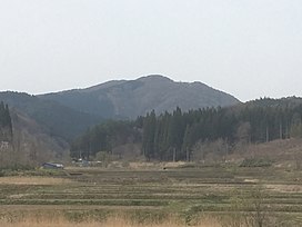
459:
343:
307:
296:
263:. Its peak lies within the city of Aomori. It has an elevation of 468 meters (1,535 ft).
252:
192:
276:
236:
164:
390:
185:
506:
433:
532:
240:
168:
122:
204:
256:
244:
172:
311:
76:
63:
275:
basalts, dacite, rhyolite near its peak with marine mudstone from the same
323:
272:
44:
300:
280:
248:
303:
over the mound where the relic is claimed to be buried.
203:
198:
184:
132:
97:
92:
53:
43:
38:
21:
116:
509:[Mount Bonju Aomori Prefectural Forest].
436:[Mount Bonju Aomori Prefectural Forest].
228:
222:
107:
8:
18:
479:
477:
16:Mountain in the Tsugaru Mountains, Japan
335:
255:between the central part of Aomori and
7:
564:Protected areas established in 1968
271:Mount Bonju is entirely made up of
151:
14:
285:Aomori Bay West Coast Fault Zone
150:
143:
27:
295:Local lore claims that some of
259:. The mountain lies within the
539:Mountains of Aomori Prefecture
261:Mount Bonju Prefectural Forest
235:is a mountain located between
1:
251:near the southern end of the
559:1968 establishments in Japan
229:
585:
370:Geological Survey of Japan
310:as a commemoration to the
117:
49:468 m (1,535 ft)
554:Sacred mountains of Japan
223:
137:
26:
318:Climbing and recreation
108:
77:40.80000°N 140.57556°E
279:near its base. Blue
513:(in Japanese). 2015
440:(in Japanese). 2015
391:"Agates from Japan"
82:40.80000; 140.57556
73: /
39:Highest point
569:IUCN Category III
308:Aomori Prefecture
297:Shakyamuni Buddha
253:Tsugaru Mountains
215:
214:
193:Tsugaru Mountains
576:
523:
522:
520:
518:
503:
497:
496:
494:
492:
485:"自然豊かで神秘的な山・梵珠山"
481:
472:
471:
469:
467:
456:
450:
449:
447:
445:
430:
424:
423:
421:
419:
408:
402:
401:
399:
397:
387:
381:
380:
378:
376:
362:
356:
355:
353:
351:
340:
234:
232:
226:
225:
207:
188:
154:
153:
147:
120:
119:
113:
111:
88:
87:
85:
84:
83:
78:
74:
71:
70:
69:
66:
31:
19:
584:
583:
579:
578:
577:
575:
574:
573:
529:
528:
527:
526:
516:
514:
505:
504:
500:
490:
488:
483:
482:
475:
465:
463:
458:
457:
453:
443:
441:
432:
431:
427:
417:
415:
410:
409:
405:
395:
393:
389:
388:
384:
374:
372:
364:
363:
359:
349:
347:
342:
341:
337:
332:
320:
293:
269:
220:
205:
186:
180:
179:
178:
177:
176:
162:
161:
160:
159:
155:
128:
105:
81:
79:
75:
72:
67:
64:
62:
60:
59:
34:
17:
12:
11:
5:
582:
580:
572:
571:
566:
561:
556:
551:
546:
541:
531:
530:
525:
524:
498:
473:
451:
425:
403:
382:
357:
334:
333:
331:
328:
319:
316:
292:
289:
268:
265:
213:
212:
209:
201:
200:
196:
195:
190:
182:
181:
163:
157:
156:
149:
148:
142:
141:
140:
139:
138:
135:
134:
130:
129:
127:
126:
114:
101:
99:
95:
94:
90:
89:
57:
51:
50:
47:
41:
40:
36:
35:
32:
24:
23:
15:
13:
10:
9:
6:
4:
3:
2:
581:
570:
567:
565:
562:
560:
557:
555:
552:
550:
547:
545:
544:Aomori (city)
542:
540:
537:
536:
534:
512:
508:
502:
499:
486:
480:
478:
474:
462:(in Japanese)
461:
455:
452:
439:
435:
429:
426:
414:. 28 May 2019
413:
407:
404:
392:
386:
383:
371:
367:
361:
358:
346:(in Japanese)
345:
339:
336:
329:
327:
325:
317:
315:
313:
309:
304:
302:
298:
291:Human history
290:
288:
286:
282:
278:
274:
266:
264:
262:
258:
254:
250:
246:
242:
238:
231:
219:
210:
208:
206:Easiest route
202:
197:
194:
191:
189:
183:
174:
170:
166:
146:
136:
131:
124:
115:
110:
103:
102:
100:
96:
91:
86:
58:
56:
52:
48:
46:
42:
37:
33:Seen from SSE
30:
25:
20:
515:. Retrieved
510:
507:"青森県民の森・梵珠山"
501:
489:. Retrieved
464:. Retrieved
454:
442:. Retrieved
437:
434:"青森県民の森・梵珠山"
428:
416:. Retrieved
406:
394:. Retrieved
385:
373:. Retrieved
369:
366:"GeomapNavi"
360:
348:. Retrieved
338:
321:
305:
294:
270:
260:
217:
216:
187:Parent range
549:Goshogawara
257:Goshogawara
245:Goshogawara
218:Mount Bonju
173:Goshogawara
158:Mount Bonju
98:Native name
80: /
68:140°34′32″E
55:Coordinates
22:Mount Bonju
533:Categories
330:References
312:centennial
230:Bonju-san
133:Geography
109:Bonju-san
65:40°48′0″N
45:Elevation
517:28 April
491:29 April
466:28 April
444:28 April
418:28 April
396:28 April
375:28 April
350:28 April
324:basecamp
211:footpath
199:Climbing
511:Aptinet
438:Aptinet
273:Miocene
267:Geology
237:Namioka
175:, Japan
165:Namioka
241:Aomori
169:Aomori
93:Naming
460:"梵珠山"
344:"梵珠山"
301:onibi
281:agate
277:epoch
249:Japan
519:2020
493:2020
468:2020
446:2020
420:2020
398:2020
377:2020
352:2020
243:and
123:Ainu
224:梵珠山
104:梵珠山
535::
476:^
368:.
287:.
247:,
239:,
227:,
171:/
167:,
118:ポニ
521:.
495:.
470:.
448:.
422:.
400:.
379:.
354:.
233:)
221:(
125:)
121:(
112:)
106:(
Text is available under the Creative Commons Attribution-ShareAlike License. Additional terms may apply.