69:
62:
316:
300:
324:
308:
961:. A striking, flat-topped butte 2,830 metres (9,280 ft) high.that is very prominent and can be seen from great distances standing 2 nautical miles (3.7 km; 2.3 mi) northwest of Miller Butte. Discovered by the United States Victoria Land Traverse Party, 1959-60. Louis J. Roberts, USGS surveyor with this party, proposed the name "Flattop Mountain," but to avoid duplication the US-ACAN named it for Roberts who was first to survey the feature.
451:. A very prominent mountain that is surmounted by three peaks, the highest 2,505 metres (8,219 ft) high, standing 5 nautical miles (9.3 km; 5.8 mi) southeast of Mount Southard. Discovered and named by the United States Victoria Land Traverse party, 1959-60. So named because it was the first mountain visited by the traverse party after crossing the interior plateau and not seeing any mountains or landmark features for nearly three months.
40:
413:. A lone mountain 2,400 metres (7,900 ft) high standing 5 nautical miles (9.3 km; 5.8 mi) northwest of Welcome Mountain in the northwest extremity of the Outback Nunataks. Named by US-ACAN for Rupert B. Southard, Chief, Office of International Activities, USGS, with responsibility for USGS field parties working in Antarctica; later Chief of the Topograpic Division of USGS.
1357:. A group of small, rather isolated nunataks about 6 nautical miles (11 km; 6.9 mi) southwest of the Helliwell Hills and 20 nautical miles (37 km; 23 mi) northeast of Welcome Mountain of the Outback Nunataks. Named by US-ACAN for Neal Potter, economist, McMurdo Station, 1965-66, who made a study of the economic potentials of Antarctica.
1273:. A large, bare mountain 2,285 metres (7,497 ft) high which stands 10 nautical miles (19 km; 12 mi) east of Mount Bower and is the dominant feature in the east part of the Outback Nunataks. First mapped by the United States Victoria Land Traverse party, 1959-60. Named by US-ACAN for John G. Weihaupt, seismologist with this party.
2054:
1972:
679:. A loose chain of rock and ice bluffs that trend generally north–south for 5 nautical miles (9.3 km; 5.8 mi), situated near the center of the Outback Nunataks, about 10 nautical miles (19 km; 12 mi) northwest of Mount Weihaupt. Named by US-ACAN for Harold L. Coleman, meteorologist at South Pole Station, 1968.
725:. A somewhat isolated nunatak, situated 3 nautical miles (5.6 km; 3.5 mi) west-northwest of Doescher Nunatak and 15 nautical miles (28 km; 17 mi) north-northwest of Mount Weihaupt. Named by US-ACAN after Wilfred I. Doe, United States Navy, hospital corpsman with the McMurdo Station winter party, 1967.
1437:. An isolated, ridgelike outcropping of rocks about 4 nautical miles (7.4 km; 4.6 mi) long, standing 15 nautical miles (28 km; 17 mi) south of Mount Weihaupt in the south extremity of the Outback Nunataks. Named by US-ACAN for Karl R. Johannessen, meteorologist at McMurdo Station, 1967-68.
847:. A ridgelike mountain 2,510 metres (8,230 ft) high standing 3 nautical miles (5.6 km; 3.5 mi) northwest of Mount Bower. Named by US-ACAN for Albert T. Joern, a researcher in physiopsychology with the winter party at South Pole Station, 1968.
527:. Two prominent rock nunataks along an ice cliff, situated 7 nautical miles (13 km; 8.1 mi) southwest of Welcome Mountain. Named by US-ACAN to express appreciation for the dedicated support provided to Antarctic programs by home-based personnel.
1475:. A large, mainly ice-free mountain 2,805 metres (9,203 ft) high situated 20 nautical miles (37 km; 23 mi) south-southeast of Roberts Butte of the Outback Nunataks, and 11 nautical miles (20 km; 13 mi) west-northwest of the
641:. A small, bare rock mountain 2,440 metres (8,010 ft) high situated 2.5 nautical miles (4.6 km; 2.9 mi) east-southeast of Mount Walton. Named by US-ACAN for Dan M. Chadwick, meteorologist at South Pole Station, 1968.
885:. A prominent mountain 2,610 metres (8,560 ft) high standing 6 nautical miles (11 km; 6.9 mi) east-northeast of Roberts Butte. Named by US-ACAN for John R. Bower, ionospheric physicist at South Pole Station, 1968.
1197:. A small but conspicuous mountain 2,120 metres (6,960 ft) high standing 6 nautical miles (11 km; 6.9 mi) northwest of Mount Weihaupt. Named by US-ACAN for Terence T. Blair, biologist at McMurdo Station, 1966-67.
1517:. A lone nunatak located 2 nautical miles (3.7 km; 2.3 mi) west of the south end of Frontier Mountain. Named by US-ACAN for Ronald F. Wilds, aviation machinist's mate with USN Squadron VX-6 at McMurdo Station, 1966.
2058:
1976:
1075:. A group of rocks along an ice bluff situated 5 nautical miles (9.3 km; 5.8 mi) southeast of Miller Butte. Named by US-ACAN for Lian Chan, engaged in laboratory management, McMurdo Station winter party, 1968.
1037:. A small mountain situated 1 nautical mile (1.9 km; 1.2 mi) east of Miller Butte. Named by US-ACAN for Robert W. Koons, United States ArmyRP logistics coordinator with the McMurdo Station winter party, 1968.
565:. A north-facing rock and ice cliff, about 4 nautical miles (7.4 km; 4.6 mi) long, situated just northwest of Mount Walton. Named by US-ACAN for Hain Oona, ionospheric physicist at South Pole Station, 1968.
923:. A mountain, 2,270 metres (7,450 ft) high, standing 10 nautical miles (19 km; 12 mi) west-southwest of Mount Weihaupt. Named by US-AC AN for Richard Spatz, station engineer at McMurdo Station, 1968.
603:. A sharp, bare mountain 2,460 metres (8,070 ft) high rising midway between Oona Cliff and Mount Chadwick. Named by US-ACAN for Fred W. Walton, geomagnetist/seismologist at South Pole Station, 1968.
1113:. A small, isolated bluff standing 9 nautical miles (17 km; 10 mi) east-southeast of Miller Butte. Named by US-ACAN for Jeffrey J. Saunders, biolab technician at McMurdo Station, 1965-66.
1395:. A group of small nunataks about 27 nautical miles (50 km; 31 mi) east-northeast of Welcome Mountain of the Outback Nunataks and 8 nautical miles (15 km; 9.2 mi) southeast of
763:. A somewhat isolated nunatak situated 13 nautical miles (24 km; 15 mi) north of Mount Weihaupt. Named by US-ACAN for Roger L. Doescher, glaciologist, McMurdo Station, 1967-68.
1235:. A sharp rock peak about 3 nautical miles (5.6 km; 3.5 mi) northwest of Mount Weihaupt. Named by US-ACAN for David J. Nims, ionospheric physicist at McMurdo Station, 1968.
489:. A lone nunatak standing 3 nautical miles (5.6 km; 3.5 mi) southeast of Welcome Mountain. Named by US-ACAN for Michael A. de Camp, biologist at McMurdo Station, 1966-67.
999:. A large rock butte located 2 nautical miles (3.7 km; 2.3 mi) southeast of Roberts Butte. Named by US-ACAN for Carl D. Miller, geophysicist at McMurdo Station, 1967-68.
1159:. A small rock peak 5 nautical miles (9.3 km; 5.8 mi) north-northeast of Mount Weihaupt. Named by US-ACAN for Edward Derbyshire, geologist at McMurdo Station, 1966-67.
204:
and mountains which are distributed over an area about 40 nautical miles (74 km; 46 mi) long by 20 nautical miles (37 km; 23 mi) wide. The group lies south of
1311:. Low rock peaks about 2 nautical miles (3.7 km; 2.3 mi) south of Mount Weihaupt. Named by US-ACAN for Daniel R. Womochel, biologist at McMurdo Station, 1967-68.
801:. A nunatak about 8 nautical miles (15 km; 9.2 mi) north-northeast of Mount Weihaupt. Named by US-ACAN for Tien H. Wu, glaciologist at McMurdo Station, 1966-67.
375:
Northwestern features include Mount
Southard, Welcome Mountain, De Camp Nunatak, The Office Girls, Oona Cliff, Mount Walton, Mount Chadwick and Coleman Bluffs.
114:
1319:
Nearby features include, clockwise from the north, Potter
Nunataks, Fitzsimmons Nunataks, Johannessen Nunataks, Frontier Mountain and Wilds Nunatak.
61:
1980:
1479:, near the edge of the featureless, interior ice plateau. Named by the northern party of NZGSAE, 1962-63, because of its geographical location.
163:
809:
Southwestern features include Mount Joern, Mount Bower, Mount Spatz, Roberts Butte, Miller Butte, Mount Koons, Chan Rocks and
Saunders Bluff.
241:
2077:
2062:
233:
303:
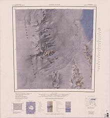
1:250,000 scale topographic map of
Outback Nunataks showing the course of the U.S. Victoria Land Traverse party 1959–60.
107:
1489:
1447:
1409:
1367:
1329:
1283:
1245:
1207:
1169:
1131:
1085:
1047:
1009:
971:
933:
895:
857:
819:
773:
735:
697:
651:
613:
575:
537:
499:
461:
423:
385:
261:
232:
The
Outback Nunataks were discovered by the United States Victoria Land Traverse party, 1959–60, and mapped by
244:(US-ACAN) for their remote position at the posterior side of the large mountain belt that extends from the
2082:
1121:
Southeastern features include
Derbyshire Peak, Mount Blair, Nims Peak, Mount Weihaupt and Womochel Peaks.
315:
288:
299:
283:
323:
307:
348:
278:
237:
360:
2003:
352:
221:
213:
2035:
331:
The terrain to the west of the nunataks is a featureless expanse of the polar plateau. The
2019:
1396:
344:
340:
336:
217:
209:
1987:
1476:
364:
39:
2071:
99:
1954:
1399:. Named by US-ACAN for John M. Fitzsimmons, biologist at McMurdo Station, 1965-66.
332:
273:
205:
356:
1504:
1491:
1462:
1449:
1424:
1411:
1382:
1369:
1344:
1331:
1298:
1285:
1260:
1247:
1222:
1209:
1184:
1171:
1146:
1133:
1100:
1087:
1062:
1049:
1024:
1011:
986:
973:
948:
935:
910:
897:
872:
859:
834:
821:
788:
775:
750:
737:
712:
699:
666:
653:
628:
615:
590:
577:
552:
539:
514:
501:
476:
463:
438:
425:
400:
387:
179:
165:
130:
116:
687:
Northeastern features include Doe
Nunatak, Doescher Nunatak and Wu Nunatak.
17:
245:
201:
322:
314:
306:
298:
1554:
1552:
1550:
1548:
1546:
1544:
1593:
1591:
1704:
1702:
1531:
1529:
1962:(2 ed.), United States Board on Geographic Names
1582:
106:
95:
87:
49:
32:
1558:
240:air photos, 1959–64. They were so named by the
1597:
1570:
8:
27:Mountain group in Victoria Land, Antarctica
29:
68:
1981:United States Board on Geographic Names
1936:
1924:
1912:
1900:
1888:
1876:
1864:
1852:
1840:
1828:
1816:
1804:
1792:
1780:
1768:
1756:
1744:
1732:
1720:
1708:
1693:
1681:
1669:
1657:
1645:
1633:
1621:
1609:
1535:
1525:
2040:, USGS: United States Geographic Board
2024:, USGS: United States Geographic Board
2008:, USGS: United States Geographic Board
1992:, USGS: United States Geographic Board
242:Advisory Committee on Antarctic Names
7:
2061:from websites or documents of the
1979:from websites or documents of the
25:
1956:Geographic Names of the Antarctic
2057: This article incorporates
2052:
1975: This article incorporates
1970:
67:
60:
38:
2063:United States Geological Survey
234:United States Geological Survey
1953:Alberts, Fred G., ed. (1995),
220:, adjacent to the featureless
1:
248:to the interior ice plateau.
200:) are a series of bare rock
289:GPX (secondary coordinates)
2099:
2078:Nunataks of Victoria Land
284:GPX (primary coordinates)
259:Map all coordinates using
54:
37:
267:Download coordinates as:
236:(USGS) from surveys and
44:Outback Nunataks in 2019
1583:Freyberg Mountains USGS
2059:public domain material
1977:public domain material
343:are to the north. The
328:
320:
312:
304:
228:Exploration and naming
1559:Welcome Mountain USGS
1117:Southeastern features
805:Southwestern features
683:Northeastern features
371:Northwestern features
359:are to the east. The
326:
318:
310:
302:
279:GPX (all coordinates)
1403:Johannessen Nunataks
1361:Fitzsimmons Nunataks
1939:, pp. 812–813.
1598:Sequence Hills USGS
1501: /
1459: /
1421: /
1379: /
1341: /
1295: /
1257: /
1219: /
1181: /
1143: /
1097: /
1059: /
1021: /
983: /
945: /
907: /
869: /
831: /
785: /
747: /
709: /
663: /
625: /
587: /
549: /
511: /
473: /
435: /
397: /
327:Region to the south
311:Region to the north
175: /
126: /
2005:Freyberg Mountains
1571:Daniels Range USGS
1505:73.017°S 160.217°E
1463:72.983°S 160.333°E
1425:72.867°S 161.183°E
1383:72.133°S 161.700°E
1345:72.033°S 161.167°E
1299:72.667°S 161.067°E
1261:72.617°S 161.050°E
1223:72.567°S 160.967°E
1185:72.533°S 160.817°E
1147:72.517°S 161.100°E
1101:72.750°S 160.733°E
1063:72.750°S 160.500°E
1025:72.717°S 160.367°E
987:72.700°S 160.250°E
949:72.650°S 160.133°E
911:72.683°S 160.550°E
873:72.617°S 160.500°E
835:72.583°S 160.400°E
789:72.483°S 161.133°E
751:72.383°S 160.983°E
713:72.367°S 160.783°E
667:72.467°S 160.617°E
629:72.500°S 160.433°E
591:72.483°S 160.300°E
553:72.450°S 160.150°E
515:72.333°S 160.017°E
477:72.267°S 160.367°E
439:72.233°S 160.200°E
401:72.183°S 159.933°E
367:are to the south.
349:Freyberg Mountains
329:
321:
319:Region to the east
313:
305:
238:United States Navy
180:72.500°S 160.500°E
131:72.500°S 160.500°E
1441:Frontier Mountain
353:Monument Nunataks
214:Monument Nunataks
154:
153:
108:Range coordinates
16:(Redirected from
2090:
2056:
2055:
2047:
2046:
2045:
2037:Welcome Mountain
2031:
2030:
2029:
2015:
2014:
2013:
1999:
1998:
1997:
1974:
1973:
1969:
1968:
1967:
1961:
1940:
1934:
1928:
1922:
1916:
1910:
1904:
1898:
1892:
1886:
1880:
1874:
1868:
1862:
1856:
1850:
1844:
1838:
1832:
1826:
1820:
1814:
1808:
1802:
1796:
1790:
1784:
1778:
1772:
1766:
1760:
1754:
1748:
1742:
1736:
1730:
1724:
1718:
1712:
1706:
1697:
1691:
1685:
1679:
1673:
1667:
1661:
1655:
1649:
1643:
1637:
1631:
1625:
1619:
1613:
1607:
1601:
1595:
1586:
1580:
1574:
1568:
1562:
1556:
1539:
1533:
1516:
1515:
1513:
1512:
1511:
1510:-73.017; 160.217
1506:
1502:
1499:
1498:
1497:
1494:
1474:
1473:
1471:
1470:
1469:
1468:-72.983; 160.333
1464:
1460:
1457:
1456:
1455:
1452:
1436:
1435:
1433:
1432:
1431:
1430:-72.867; 161.183
1426:
1422:
1419:
1418:
1417:
1414:
1394:
1393:
1391:
1390:
1389:
1388:-72.133; 161.700
1384:
1380:
1377:
1376:
1375:
1372:
1356:
1355:
1353:
1352:
1351:
1350:-72.033; 161.167
1346:
1342:
1339:
1338:
1337:
1334:
1310:
1309:
1307:
1306:
1305:
1304:-72.667; 161.067
1300:
1296:
1293:
1292:
1291:
1288:
1272:
1271:
1269:
1268:
1267:
1266:-72.617; 161.050
1262:
1258:
1255:
1254:
1253:
1250:
1234:
1233:
1231:
1230:
1229:
1228:-72.567; 160.967
1224:
1220:
1217:
1216:
1215:
1212:
1196:
1195:
1193:
1192:
1191:
1190:-72.533; 160.817
1186:
1182:
1179:
1178:
1177:
1174:
1158:
1157:
1155:
1154:
1153:
1152:-72.517; 161.100
1148:
1144:
1141:
1140:
1139:
1136:
1112:
1111:
1109:
1108:
1107:
1106:-72.750; 160.733
1102:
1098:
1095:
1094:
1093:
1090:
1074:
1073:
1071:
1070:
1069:
1068:-72.750; 160.500
1064:
1060:
1057:
1056:
1055:
1052:
1036:
1035:
1033:
1032:
1031:
1030:-72.717; 160.367
1026:
1022:
1019:
1018:
1017:
1014:
998:
997:
995:
994:
993:
992:-72.700; 160.250
988:
984:
981:
980:
979:
976:
960:
959:
957:
956:
955:
954:-72.650; 160.133
950:
946:
943:
942:
941:
938:
922:
921:
919:
918:
917:
916:-72.683; 160.550
912:
908:
905:
904:
903:
900:
884:
883:
881:
880:
879:
878:-72.617; 160.500
874:
870:
867:
866:
865:
862:
846:
845:
843:
842:
841:
840:-72.583; 160.400
836:
832:
829:
828:
827:
824:
800:
799:
797:
796:
795:
794:-72.483; 161.133
790:
786:
783:
782:
781:
778:
762:
761:
759:
758:
757:
756:-72.383; 160.983
752:
748:
745:
744:
743:
740:
729:Doescher Nunatak
724:
723:
721:
720:
719:
718:-72.367; 160.783
714:
710:
707:
706:
705:
702:
678:
677:
675:
674:
673:
672:-72.467; 160.617
668:
664:
661:
660:
659:
656:
640:
639:
637:
636:
635:
634:-72.500; 160.433
630:
626:
623:
622:
621:
618:
602:
601:
599:
598:
597:
596:-72.483; 160.300
592:
588:
585:
584:
583:
580:
564:
563:
561:
560:
559:
558:-72.450; 160.150
554:
550:
547:
546:
545:
542:
526:
525:
523:
522:
521:
520:-72.333; 160.017
516:
512:
509:
508:
507:
504:
493:The Office Girls
488:
487:
485:
484:
483:
482:-72.267; 160.367
478:
474:
471:
470:
469:
466:
450:
449:
447:
446:
445:
444:-72.233; 160.200
440:
436:
433:
432:
431:
428:
417:Welcome Mountain
412:
411:
409:
408:
407:
406:-72.183; 159.933
402:
398:
395:
394:
393:
390:
222:interior plateau
199:
198:
196:
195:
194:
192:
191:Outback Nunataks
187:
186:
185:-72.500; 160.500
181:
176:
173:
172:
171:
168:
158:Outback Nunataks
150:
149:
147:
146:
145:
143:
142:Outback Nunataks
138:
137:
136:-72.500; 160.500
132:
127:
124:
123:
122:
119:
75:Outback Nunataks
71:
70:
64:
42:
33:Outback Nunataks
30:
21:
2098:
2097:
2093:
2092:
2091:
2089:
2088:
2087:
2068:
2067:
2053:
2050:
2043:
2041:
2034:
2027:
2025:
2018:
2011:
2009:
2002:
1995:
1993:
1986:
1971:
1965:
1963:
1959:
1952:
1948:
1943:
1935:
1931:
1923:
1919:
1911:
1907:
1899:
1895:
1887:
1883:
1875:
1871:
1863:
1859:
1851:
1847:
1839:
1835:
1827:
1823:
1815:
1811:
1803:
1799:
1791:
1787:
1779:
1775:
1767:
1763:
1755:
1751:
1743:
1739:
1731:
1727:
1719:
1715:
1707:
1700:
1692:
1688:
1680:
1676:
1668:
1664:
1656:
1652:
1644:
1640:
1632:
1628:
1620:
1616:
1608:
1604:
1596:
1589:
1581:
1577:
1569:
1565:
1557:
1542:
1534:
1527:
1523:
1509:
1507:
1503:
1500:
1495:
1492:
1490:
1488:
1487:
1485:
1467:
1465:
1461:
1458:
1453:
1450:
1448:
1446:
1445:
1443:
1429:
1427:
1423:
1420:
1415:
1412:
1410:
1408:
1407:
1405:
1397:Helliwell Hills
1387:
1385:
1381:
1378:
1373:
1370:
1368:
1366:
1365:
1363:
1349:
1347:
1343:
1340:
1335:
1332:
1330:
1328:
1327:
1325:
1323:Potter Nunataks
1317:
1315:Nearby features
1303:
1301:
1297:
1294:
1289:
1286:
1284:
1282:
1281:
1279:
1265:
1263:
1259:
1256:
1251:
1248:
1246:
1244:
1243:
1241:
1227:
1225:
1221:
1218:
1213:
1210:
1208:
1206:
1205:
1203:
1189:
1187:
1183:
1180:
1175:
1172:
1170:
1168:
1167:
1165:
1151:
1149:
1145:
1142:
1137:
1134:
1132:
1130:
1129:
1127:
1125:Derbyshire Peak
1119:
1105:
1103:
1099:
1096:
1091:
1088:
1086:
1084:
1083:
1081:
1067:
1065:
1061:
1058:
1053:
1050:
1048:
1046:
1045:
1043:
1029:
1027:
1023:
1020:
1015:
1012:
1010:
1008:
1007:
1005:
991:
989:
985:
982:
977:
974:
972:
970:
969:
967:
953:
951:
947:
944:
939:
936:
934:
932:
931:
929:
915:
913:
909:
906:
901:
898:
896:
894:
893:
891:
877:
875:
871:
868:
863:
860:
858:
856:
855:
853:
839:
837:
833:
830:
825:
822:
820:
818:
817:
815:
807:
793:
791:
787:
784:
779:
776:
774:
772:
771:
769:
755:
753:
749:
746:
741:
738:
736:
734:
733:
731:
717:
715:
711:
708:
703:
700:
698:
696:
695:
693:
685:
671:
669:
665:
662:
657:
654:
652:
650:
649:
647:
633:
631:
627:
624:
619:
616:
614:
612:
611:
609:
595:
593:
589:
586:
581:
578:
576:
574:
573:
571:
557:
555:
551:
548:
543:
540:
538:
536:
535:
533:
519:
517:
513:
510:
505:
502:
500:
498:
497:
495:
481:
479:
475:
472:
467:
464:
462:
460:
459:
457:
455:De Camp Nunatak
443:
441:
437:
434:
429:
426:
424:
422:
421:
419:
405:
403:
399:
396:
391:
388:
386:
384:
383:
381:
373:
345:Rennick Glacier
341:Helliwell Hills
337:Usarp Mountains
297:
296:
295:
294:
293:
254:
230:
218:Rennick Glacier
210:Usarp Mountains
190:
188:
184:
182:
178:
177:
174:
169:
166:
164:
162:
161:
141:
139:
135:
133:
129:
128:
125:
120:
117:
115:
113:
112:
83:
82:
81:
80:
79:
78:
77:
76:
72:
45:
28:
23:
22:
15:
12:
11:
5:
2096:
2094:
2086:
2085:
2080:
2070:
2069:
2049:
2048:
2032:
2021:Sequence Hills
2016:
2000:
1984:
1949:
1947:
1944:
1942:
1941:
1929:
1927:, p. 261.
1917:
1915:, p. 373.
1905:
1903:, p. 243.
1893:
1891:, p. 586.
1881:
1879:, p. 821.
1869:
1867:, p. 802.
1857:
1855:, p. 527.
1845:
1833:
1831:, p. 184.
1821:
1819:, p. 650.
1809:
1807:, p. 128.
1797:
1795:, p. 401.
1785:
1783:, p. 492.
1773:
1771:, p. 622.
1761:
1759:, p. 699.
1749:
1737:
1735:, p. 372.
1725:
1723:, p. 825.
1713:
1711:, p. 193.
1698:
1696:, p. 144.
1686:
1684:, p. 126.
1674:
1672:, p. 794.
1662:
1660:, p. 545.
1650:
1648:, p. 540.
1638:
1636:, p. 179.
1626:
1624:, p. 803.
1614:
1612:, p. 695.
1602:
1587:
1575:
1563:
1540:
1538:, p. 549.
1524:
1522:
1519:
1484:
1481:
1477:Sequence Hills
1442:
1439:
1404:
1401:
1362:
1359:
1324:
1321:
1316:
1313:
1278:
1277:Womochel Peaks
1275:
1240:
1239:Mount Weihaupt
1237:
1202:
1199:
1164:
1161:
1126:
1123:
1118:
1115:
1080:
1079:Saunders Bluff
1077:
1042:
1039:
1004:
1001:
966:
963:
928:
925:
890:
887:
852:
849:
814:
811:
806:
803:
768:
765:
730:
727:
692:
689:
684:
681:
646:
645:Coleman Bluffs
643:
608:
607:Mount Chadwick
605:
570:
567:
532:
529:
494:
491:
456:
453:
418:
415:
380:
379:Mount Southard
377:
372:
369:
365:Sequence Hills
292:
291:
286:
281:
276:
270:
264:
257:
256:
255:
253:
250:
229:
226:
152:
151:
110:
104:
103:
97:
93:
92:
89:
85:
84:
74:
73:
66:
65:
59:
58:
57:
56:
55:
52:
51:
47:
46:
43:
35:
34:
26:
24:
14:
13:
10:
9:
6:
4:
3:
2:
2095:
2084:
2083:Pennell Coast
2081:
2079:
2076:
2075:
2073:
2066:
2064:
2060:
2039:
2038:
2033:
2023:
2022:
2017:
2007:
2006:
2001:
1991:
1990:
1989:Daniels Range
1985:
1982:
1978:
1958:
1957:
1951:
1950:
1945:
1938:
1933:
1930:
1926:
1921:
1918:
1914:
1909:
1906:
1902:
1897:
1894:
1890:
1885:
1882:
1878:
1873:
1870:
1866:
1861:
1858:
1854:
1849:
1846:
1843:, p. 72.
1842:
1837:
1834:
1830:
1825:
1822:
1818:
1813:
1810:
1806:
1801:
1798:
1794:
1789:
1786:
1782:
1777:
1774:
1770:
1765:
1762:
1758:
1753:
1750:
1747:, p. 84.
1746:
1741:
1738:
1734:
1729:
1726:
1722:
1717:
1714:
1710:
1705:
1703:
1699:
1695:
1690:
1687:
1683:
1678:
1675:
1671:
1666:
1663:
1659:
1654:
1651:
1647:
1642:
1639:
1635:
1630:
1627:
1623:
1618:
1615:
1611:
1606:
1603:
1599:
1594:
1592:
1588:
1584:
1579:
1576:
1572:
1567:
1564:
1560:
1555:
1553:
1551:
1549:
1547:
1545:
1541:
1537:
1532:
1530:
1526:
1520:
1518:
1514:
1483:Wilds Nunatak
1482:
1480:
1478:
1472:
1440:
1438:
1434:
1402:
1400:
1398:
1392:
1360:
1358:
1354:
1322:
1320:
1314:
1312:
1308:
1276:
1274:
1270:
1238:
1236:
1232:
1200:
1198:
1194:
1162:
1160:
1156:
1124:
1122:
1116:
1114:
1110:
1078:
1076:
1072:
1040:
1038:
1034:
1002:
1000:
996:
964:
962:
958:
927:Roberts Butte
926:
924:
920:
888:
886:
882:
850:
848:
844:
812:
810:
804:
802:
798:
766:
764:
760:
728:
726:
722:
690:
688:
682:
680:
676:
644:
642:
638:
606:
604:
600:
568:
566:
562:
530:
528:
524:
492:
490:
486:
454:
452:
448:
416:
414:
410:
378:
376:
370:
368:
366:
362:
358:
354:
350:
346:
342:
338:
334:
325:
317:
309:
301:
290:
287:
285:
282:
280:
277:
275:
272:
271:
269:
268:
263:
262:OpenStreetMap
260:
251:
249:
247:
243:
239:
235:
227:
225:
223:
219:
215:
211:
207:
203:
197:
159:
148:
111:
109:
105:
101:
100:Victoria Land
98:
94:
90:
86:
63:
53:
48:
41:
36:
31:
19:
2051:
2042:, retrieved
2036:
2026:, retrieved
2020:
2010:, retrieved
2004:
1994:, retrieved
1988:
1964:, retrieved
1955:
1937:Alberts 1995
1932:
1925:Alberts 1995
1920:
1913:Alberts 1995
1908:
1901:Alberts 1995
1896:
1889:Alberts 1995
1884:
1877:Alberts 1995
1872:
1865:Alberts 1995
1860:
1853:Alberts 1995
1848:
1841:Alberts 1995
1836:
1829:Alberts 1995
1824:
1817:Alberts 1995
1812:
1805:Alberts 1995
1800:
1793:Alberts 1995
1788:
1781:Alberts 1995
1776:
1769:Alberts 1995
1764:
1757:Alberts 1995
1752:
1745:Alberts 1995
1740:
1733:Alberts 1995
1728:
1721:Alberts 1995
1716:
1709:Alberts 1995
1694:Alberts 1995
1689:
1682:Alberts 1995
1677:
1670:Alberts 1995
1665:
1658:Alberts 1995
1653:
1646:Alberts 1995
1641:
1634:Alberts 1995
1629:
1622:Alberts 1995
1617:
1610:Alberts 1995
1605:
1578:
1566:
1536:Alberts 1995
1486:
1444:
1406:
1364:
1326:
1318:
1280:
1242:
1204:
1166:
1128:
1120:
1082:
1044:
1006:
968:
965:Miller Butte
930:
892:
854:
816:
808:
770:
732:
694:
686:
648:
610:
572:
569:Mount Walton
534:
496:
458:
420:
382:
374:
361:Rennick Névé
330:
266:
265:
258:
231:
212:and west of
157:
155:
102:, Antarctica
1508: /
1466: /
1428: /
1386: /
1348: /
1302: /
1264: /
1226: /
1188: /
1163:Mount Blair
1150: /
1104: /
1066: /
1028: /
1003:Mount Koons
990: /
952: /
914: /
889:Mount Spatz
876: /
851:Mount Bower
838: /
813:Mount Joern
792: /
754: /
716: /
691:Doe Nunatak
670: /
632: /
594: /
556: /
518: /
480: /
442: /
404: /
333:Emlen Peaks
206:Emlen Peaks
183: /
134: /
18:Mount Bower
2072:Categories
2044:2024-03-03
2028:2024-03-04
2012:2024-03-04
1996:2024-03-04
1966:2024-01-30
1521:References
1041:Chan Rocks
767:Wu Nunatak
531:Oona Cliff
357:Mesa Range
216:and upper
189: (
140: (
91:Antarctica
1201:Nims Peak
88:Continent
50:Geography
1496:160°13′E
1454:160°20′E
1416:161°11′E
1374:161°42′E
1336:161°10′E
1290:161°04′E
1252:161°03′E
1214:160°58′E
1176:160°49′E
1138:161°06′E
1092:160°44′E
1054:160°30′E
1016:160°22′E
978:160°15′E
940:160°08′E
902:160°33′E
864:160°30′E
826:160°24′E
780:161°08′E
742:160°59′E
704:160°47′E
658:160°37′E
620:160°26′E
582:160°18′E
544:160°09′E
506:160°01′E
468:160°22′E
430:160°12′E
392:159°56′E
363:and the
355:and the
339:and the
252:Location
246:Ross Sea
202:nunataks
170:160°30′E
121:160°30′E
1946:Sources
1493:73°01′S
1451:72°59′S
1413:72°52′S
1371:72°08′S
1333:72°02′S
1287:72°40′S
1249:72°37′S
1211:72°34′S
1173:72°32′S
1135:72°31′S
1089:72°45′S
1051:72°45′S
1013:72°43′S
975:72°42′S
937:72°39′S
899:72°41′S
861:72°37′S
823:72°35′S
777:72°29′S
739:72°23′S
701:72°22′S
655:72°28′S
617:72°30′S
579:72°29′S
541:72°27′S
503:72°20′S
465:72°16′S
427:72°14′S
389:72°11′S
335:of the
208:of the
167:72°30′S
118:72°30′S
351:, the
347:, the
96:Region
1960:(PDF)
156:The
274:KML
2074::
2065:.
1701:^
1590:^
1543:^
1528:^
224:.
1983:.
1600:.
1585:.
1573:.
1561:.
193:)
160:(
144:)
20:)
Text is available under the Creative Commons Attribution-ShareAlike License. Additional terms may apply.