52:
45:
278:
424:. Mountain, 2,440 metres (8,010 ft) high, standing 2 nautical miles (3.7 km; 2.3 mi) north of Mount Dougherty in the north part of the Queen Elizabeth Range. Mapped by the USGS from tellurometer surveys and Navy air photos, 1960-62. Named by US-ACAN for Kurt G. Sandved, Information Officer at the Office of Antarctic Programs, National Science Foundation.
669:
634:
462:. A mountain, 2,790 metres (9,150 ft) high, between Mount Sandved and Mount Cara on the main north–south ridge in the north part of the Queen Elizabeth Range. Mapped by the USGS from tellurometer surveys and Navy air photos, 1960-62. Named by US-ACAN for Ellsworth C. Dougherty, USARP biologist at McMurdo Sound, 1959-60 and 1961-62.
344:. A line of steep cliffs, interrupted by several glaciers, which form the northern escarpment of the Queen Elizabeth Range. The escarpment borders the southern side of the Nimrod Glacier which is very heavily crevassed. Named by the northern party of the NZGSAE (1961-62) because of their general inaccessibility.
673:
638:
386:. Mapped by the USGS from tellurometer surveys and Navy air photos, 1960-62. Named by US-ACAN for Walther F. Hofmann, USARP glaciologist on the Ross Ice Shelf, 1962-63.
505:
693:
78:
219:
642:
285:
Svaton Peaks are in the north of the Queen
Elizabeth Range at the north end of a block bounded by the Inaccessible Cliffs along the coast of the
44:
215:
290:
153:
191:
139:
677:
211:
71:
500:. Peak, 3,145 metres (10,318 ft) high, standing 4 nautical miles (7.4 km; 4.6 mi) north-northwest of
698:
472:
434:
396:
354:
316:
239:
382:. Snow-covered mountain, 2,000 metres (6,600 ft) high, between the mouths of Hamilton Glacier and
214:(USGS) from tellurometer surveys and Navy air photos, 1960–62. They were named by the United States
277:
266:
261:
256:
649:
383:
298:
223:
195:
286:
132:
687:
501:
294:
199:
616:
487:
474:
449:
436:
411:
398:
369:
356:
331:
318:
169:
155:
94:
80:
251:
17:
301:, Mount Hofmann, Mount Sandved, Mount Dougherty and Mount Cara.
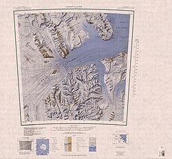
194:, Antarctica, surmounting the area between the mouths of the
522:
520:
190:) is a cluster of rugged peaks at the north end of the
624:(2 ed.), United States Board on Geographic Names
131:
123:
118:
70:
65:
32:
538:
27:Mountain range in Ross Dependency, Antarctica
8:
29:
297:to the east. Nearby features include the
276:
220:United States Antarctic Research Program
654:, USGS: United States Geological Survey
643:United States Board on Geographic Names
598:
586:
574:
562:
550:
526:
516:
506:British Antarctic Expedition, 1907–09
216:Advisory Committee on Antarctic Names
7:
210:The Svaton Peaks were mapped by the
51:
676:from websites or documents of the
641:from websites or documents of the
281:Cotton Plateau in southwest of map
25:
618:Geographic Names of the Antarctic
222:(USARP) ionospheric physicist at
694:Mountains of the Ross Dependency
672: This article incorporates
667:
637: This article incorporates
632:
218:(US-ACAN) for Ernest M. Svaton,
50:
43:
678:United States Geological Survey
212:United States Geological Survey
615:Alberts, Fred G., ed. (1995),
1:
267:GPX (secondary coordinates)
715:
262:GPX (primary coordinates)
237:Map all coordinates using
37:
245:Download coordinates as:
226:, winter 1963 and 1964.
674:public domain material
639:public domain material
282:
280:
257:GPX (all coordinates)
192:Queen Elizabeth Range
140:Queen Elizabeth Range
293:to the west and the
206:Exploration and name
539:Nimrod Glacier USGS
484: /
446: /
408: /
366: /
328: /
310:Inaccessible Cliffs
165: /
90: /
488:82.750°S 161.100°E
450:82.717°S 161.083°E
412:82.683°S 161.100°E
370:82.667°S 160.600°E
332:82.550°S 160.800°E
289:to the north, the
283:
170:82.583°S 161.000°E
95:82.583°S 161.000°E
66:Highest point
145:
144:
16:(Redirected from
706:
699:Shackleton Coast
671:
670:
661:
660:
659:
636:
635:
631:
630:
629:
623:
602:
596:
590:
584:
578:
572:
566:
560:
554:
548:
542:
536:
530:
524:
504:. Named by the
499:
498:
496:
495:
494:
493:-82.750; 161.100
489:
485:
482:
481:
480:
477:
461:
460:
458:
457:
456:
455:-82.717; 161.083
451:
447:
444:
443:
442:
439:
423:
422:
420:
419:
418:
417:-82.683; 161.100
413:
409:
406:
405:
404:
401:
381:
380:
378:
377:
376:
375:-82.667; 160.600
371:
367:
364:
363:
362:
359:
343:
342:
340:
339:
338:
337:-82.550; 160.800
333:
329:
326:
325:
324:
321:
291:Hamilton Glacier
189:
188:
186:
185:
184:
182:
177:
176:
175:-82.583; 161.000
171:
166:
163:
162:
161:
158:
135:
114:
113:
111:
110:
109:
107:
102:
101:
100:-82.583; 161.000
96:
91:
88:
87:
86:
83:
54:
53:
47:
30:
21:
714:
713:
709:
708:
707:
705:
704:
703:
684:
683:
668:
664:
657:
655:
648:
633:
627:
625:
621:
614:
610:
605:
597:
593:
585:
581:
573:
569:
561:
557:
549:
545:
537:
533:
525:
518:
514:
492:
490:
486:
483:
478:
475:
473:
471:
470:
468:
454:
452:
448:
445:
440:
437:
435:
433:
432:
430:
428:Mount Dougherty
416:
414:
410:
407:
402:
399:
397:
395:
394:
392:
384:Heilman Glacier
374:
372:
368:
365:
360:
357:
355:
353:
352:
350:
336:
334:
330:
327:
322:
319:
317:
315:
314:
312:
307:
299:Heilman Glacier
275:
274:
273:
272:
271:
232:
224:McMurdo Station
208:
196:Heilman Glacier
180:
178:
174:
172:
168:
167:
164:
159:
156:
154:
152:
151:
133:
105:
103:
99:
97:
93:
92:
89:
84:
81:
79:
77:
76:
61:
60:
59:
58:
57:
56:
55:
28:
23:
22:
15:
12:
11:
5:
712:
710:
702:
701:
696:
686:
685:
682:
681:
663:
662:
651:Nimrod Glacier
646:
611:
609:
606:
604:
603:
601:, p. 118.
591:
589:, p. 196.
579:
577:, p. 647.
567:
565:, p. 338.
555:
553:, p. 359.
543:
531:
529:, p. 726.
515:
513:
510:
467:
464:
429:
426:
391:
388:
349:
346:
311:
308:
306:
303:
287:Nimrod Glacier
270:
269:
264:
259:
254:
248:
242:
235:
234:
233:
231:
228:
207:
204:
143:
142:
137:
129:
128:
125:
121:
120:
116:
115:
74:
68:
67:
63:
62:
49:
48:
42:
41:
40:
39:
38:
35:
34:
26:
24:
14:
13:
10:
9:
6:
4:
3:
2:
711:
700:
697:
695:
692:
691:
689:
679:
675:
666:
665:
653:
652:
647:
644:
640:
620:
619:
613:
612:
607:
600:
595:
592:
588:
583:
580:
576:
571:
568:
564:
559:
556:
552:
547:
544:
540:
535:
532:
528:
523:
521:
517:
511:
509:
507:
503:
502:Mount Lysaght
497:
465:
463:
459:
427:
425:
421:
390:Mount Sandved
389:
387:
385:
379:
348:Mount Hofmann
347:
345:
341:
309:
304:
302:
300:
296:
295:Otago Glacier
292:
288:
279:
268:
265:
263:
260:
258:
255:
253:
250:
249:
247:
246:
241:
240:OpenStreetMap
238:
229:
227:
225:
221:
217:
213:
205:
203:
201:
200:Otago Glacier
197:
193:
187:
149:
141:
138:
136:
130:
126:
122:
117:
112:
75:
73:
69:
64:
46:
36:
31:
19:
656:, retrieved
650:
626:, retrieved
617:
599:Alberts 1995
594:
587:Alberts 1995
582:
575:Alberts 1995
570:
563:Alberts 1995
558:
551:Alberts 1995
546:
534:
527:Alberts 1995
469:
431:
393:
351:
313:
284:
244:
243:
236:
209:
181:Svaton Peaks
148:Svaton Peaks
147:
146:
134:Parent range
106:Svaton Peaks
33:Svaton Peaks
491: /
453: /
415: /
373: /
335: /
173: /
98: /
72:Coordinates
688:Categories
658:2024-01-03
628:2023-12-03
512:References
466:Mount Cara
179: (
127:Antarctica
104: (
18:Mount Cara
124:Continent
119:Geography
479:161°06′E
441:161°05′E
403:161°06′E
361:160°36′E
323:160°48′E
305:Features
230:Location
160:161°00′E
85:161°00′E
608:Sources
476:82°45′S
438:82°43′S
400:82°41′S
358:82°40′S
320:82°33′S
157:82°35′S
82:82°35′S
622:(PDF)
198:and
252:KML
690::
519:^
508:.
202:.
680:.
645:.
541:.
183:)
150:(
108:)
20:)
Text is available under the Creative Commons Attribution-ShareAlike License. Additional terms may apply.