153:
452:
31:
401:
160:
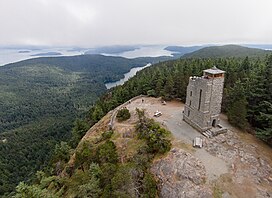
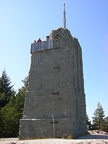
A stone observation tower patterned after a medieval watch tower stands 52 feet (16 m) above the summit, which is 2,400 feet (730 m) above sea level. It was designed by architect
78:
493:
517:
250:
146:
522:
512:
427:
486:
381:
53:
254:
315:
156:
At the top of Mount
Constitution sits a 53-foot sandstone tower, reinforced with 2 tons of steel, and measuring 18 x 28 feet at the base.
418:
208:
479:
423:
246:
405:
71:
459:
344:"Civilian Conservation Corps begins building an observation tower on Mount Constitution, Orcas Island, in August 1935"
165:
152:
122:
435:
193:
413:
126:
61:
176:, and many Canadian and American cities. On a clear day, the view encompasses locations as diverse as
320:
377:
173:
463:
238:
35:
The observation tower at the peak of Mt. Constitution as seen from an unmanned aerial vehicle
212:
197:
161:
142:
204:
185:
30:
506:
181:
169:
145:
and the second highest mountain on an ocean island in the contiguous 48 states. Only
138:
118:
451:
371:
286:
348:
177:
268:
93:
80:
189:
400:
168:
in 1936. The tower offers panoramic views of the surrounding islands, the
343:
46:
151:
196:. Mount Constitution lies within the 5,000-acre (20.2 km)
467:
436:"All Washington Peaks with 2000 Feet of Prominence"
316:"Salty Breezes. Great Views. This Is Mass Transit?"
114:
109:
70:
60:
45:
40:
23:
287:"USA 48-States Island High Points above 500 feet"
149:in the Channel Islands of California is higher.
251:National Oceanic and Atmospheric Administration
487:
16:Mountain in Washington (state), United States
8:
494:
480:
20:
309:
307:
518:Mountains of San Juan County, Washington
428:United States Department of the Interior
376:. Van Winkle Publishing Co. p. 23.
314:McCleary, Kathleen (September 5, 2003).
227:
233:
231:
7:
448:
446:
255:United States Department of Commerce
419:Geographic Names Information System
523:Washington (state) geography stubs
466:. You can help Knowledge (XXG) by
14:
450:
399:
342:Oldham, Kit (October 29, 2005).
269:"Mount Constitution, Washington"
29:
513:Mountains of Washington (state)
424:United States Geological Survey
94:48.677569028°N 122.831162383°W
1:
462:state location article is a
203:The prominence was named by
99:48.677569028; -122.831162383
460:San Juan County, Washington
166:Civilian Conservation Corps
141:, the highest point in the
539:
445:
194:Victoria, British Columbia
66:2,407 ft (734 m)
51:2,399 ft (731 m)
370:Majors, Harry M. (1975).
28:
247:National Geodetic Survey
157:
408:at Wikimedia Commons
239:"Constitution Reset"
211:of 1838-1842 for the
155:
414:"Mount Constitution"
373:Exploring Washington
188:, and the cities of
90: /
406:Mount Constitution
321:The New York Times
158:
135:Mount Constitution
54: NAVD 88
41:Highest point
24:Mount Constitution
475:
474:
404:Media related to
383:978-0-918664-00-6
209:Wilkes Expedition
174:Olympic Mountains
170:Cascade Mountains
164:and built by the
137:is a mountain on
132:
131:
56:
530:
496:
489:
482:
454:
447:
439:
431:
403:
388:
387:
367:
361:
360:
358:
356:
339:
333:
332:
330:
328:
311:
302:
301:
299:
297:
283:
277:
276:
265:
259:
258:
235:
198:Moran State Park
162:Ellsworth Storey
143:San Juan Islands
127:Washington, U.S.
105:
104:
102:
101:
100:
95:
91:
88:
87:
86:
83:
52:
33:
21:
538:
537:
533:
532:
531:
529:
528:
527:
503:
502:
501:
500:
443:
438:. Jeff Howbert.
434:
412:
397:
392:
391:
384:
369:
368:
364:
354:
352:
341:
340:
336:
326:
324:
313:
312:
305:
295:
293:
285:
284:
280:
267:
266:
262:
237:
236:
229:
224:
123:San Juan County
98:
96:
92:
89:
84:
81:
79:
77:
76:
36:
17:
12:
11:
5:
536:
534:
526:
525:
520:
515:
505:
504:
499:
498:
491:
484:
476:
473:
472:
455:
441:
440:
432:
396:
395:External links
393:
390:
389:
382:
362:
334:
303:
291:Peakbagger.com
278:
273:Peakbagger.com
260:
243:NGS Data Sheet
226:
225:
223:
220:
205:Charles Wilkes
186:Saturna Island
130:
129:
116:
112:
111:
107:
106:
74:
68:
67:
64:
58:
57:
49:
43:
42:
38:
37:
34:
26:
25:
15:
13:
10:
9:
6:
4:
3:
2:
535:
524:
521:
519:
516:
514:
511:
510:
508:
497:
492:
490:
485:
483:
478:
477:
471:
469:
465:
461:
456:
453:
449:
444:
437:
433:
429:
425:
421:
420:
415:
411:
410:
409:
407:
402:
394:
385:
379:
375:
374:
366:
363:
351:
350:
345:
338:
335:
323:
322:
317:
310:
308:
304:
292:
288:
282:
279:
274:
270:
264:
261:
256:
252:
248:
244:
240:
234:
232:
228:
221:
219:
217:
216:
210:
206:
201:
199:
195:
191:
187:
183:
182:Mount Rainier
179:
175:
171:
167:
163:
154:
150:
148:
144:
140:
136:
128:
124:
120:
117:
113:
108:
103:
75:
73:
69:
65:
63:
59:
55:
50:
48:
44:
39:
32:
27:
22:
19:
468:expanding it
457:
442:
417:
398:
372:
365:
355:February 13,
353:. Retrieved
347:
337:
327:February 13,
325:. Retrieved
319:
294:. Retrieved
290:
281:
272:
263:
242:
215:Constitution
214:
202:
159:
139:Orcas Island
134:
133:
119:Orcas Island
18:
349:HistoryLink
296:January 17,
207:during the
178:Mount Baker
147:Devils Peak
97: /
85:122°49′52″W
72:Coordinates
507:Categories
222:References
82:48°40′39″N
62:Prominence
213:USS
190:Vancouver
110:Geography
47:Elevation
115:Location
380:
192:, and
172:, the
458:This
464:stub
378:ISBN
357:2024
329:2024
298:2013
509::
426:,
422:.
416:.
346:.
318:.
306:^
289:.
271:.
253:,
249:,
245:.
241:.
230:^
218:.
200:.
184:,
180:,
125:,
121:,
495:e
488:t
481:v
470:.
430:.
386:.
359:.
331:.
300:.
275:.
257:.
Text is available under the Creative Commons Attribution-ShareAlike License. Additional terms may apply.