145:
641:
138:
665:
29:
653:
360:), causing heavy precipitation in the form of rainfall and snowfall. Winter temperatures can drop below 0 °F with wind chill factors below −10 °F. This climate supports the Johnson Glacier, Gakona Glacier, and smaller unnamed glaciers surrounding the peak.
299:
of the summit was made on March 24, 1980, by Daniel
Osborne, Steve O'Brien, Mark Hottman, and Toby Wheeler. The climbers reported that the mountain has two peaks separated one mile apart by a knife-edged ridge. The word "Gakona"
700:
705:
524:
94:
463:
618:
337:
188:
695:
454:
561:
137:
349:
459:
218:
295:
is significant as the summit rises 4,865 feet (1,483 meters) above the
Johnson Glacier in 1.3 mile (2.1 km). The
631:
685:
87:
587:
Peel, M. C.; Finlayson, B. L.; McMahon, T. A. (2007). "Updated world map of the Köppen−Geiger climate classification".
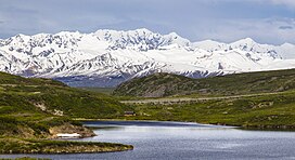
449:
356:
zone with cold, snowy winters, and cool summers. Weather systems are forced upwards by the Delta
Mountains (
64:
54:
690:
288:
275:. The heavily glaciated mountain ranks as the fourth-highest peak in the Delta Mountains. Precipitation
77:
624:
374:
279:
and glacial meltwater from the mountain's north slope drains to
Johnson Glacier → Johnson River →
292:
596:
557:
336:) means "rabbit" or "rabbit river." The mountain's toponym has been officially adopted by the
657:
645:
303:
357:
268:
213:
206:
369:
353:
333:
276:
264:
195:
679:
669:
69:
296:
284:
280:
272:
233:
202:
540:
486:
509:
397:
600:
109:
96:
28:
527:
North
America, United States, Alaska, Mount Gakona, Eastern Alaska Range
420:
252:
248:
178:
44:
531:, publications.americanalpineclub.org, Retrieved 2023-12-22.
324:
318:
309:
263:
Mount Gakona is located 22 miles (35 km) northeast of
541:
University of Alaska
Fairbanks: Alaska Native Place Names
306:
283:, whereas the south slope drains to the Gakona Glacier →
629:
321:
315:
701:
Landforms of
Southeast Fairbanks Census Area, Alaska
312:
232:
227:
212:
194:
184:
174:
166:
125:
86:
76:
63:
53:
43:
38:
21:
577:, U.S. Government Printing Office, 1967, page 358.
247:is a 9,865-foot-elevation (3,007-meter) mountain
515:, Alaskaalpineclub.com, Retrieved 2023-12-22.
415:
413:
8:
481:
479:
392:
390:
18:
706:Mountains of Unorganized Borough, Alaska
464:United States Department of the Interior
636:
386:
338:United States Board on Geographic Names
444:
442:
440:
352:system, Mount Gakona is located in a
7:
144:
455:Geographic Names Information System
14:
16:Mountain in Alaska, United States
663:
651:
639:
575:Dictionary of Alaska Place Names
302:
143:
136:
33:Southwest aspect centered at top
27:
460:United States Geological Survey
1:
696:North American 3000 m summits
556:, Volume 1, McFarland, 2015,
398:"Mount Gakona, Peakvisor.com"
350:Köppen climate classification
554:Indian Placenames in America
271:which are a subrange of the
82:7.73 mi (12.44 km)
49:9,865 ft (3,007 m)
421:"Gakona, Mount - 9,850' AK"
722:
110:63.3225394°N 145.1807369°W
59:2,313 ft (705 m)
130:
26:
115:63.3225394; -145.1807369
589:Hydrol. Earth Syst. Sci
543:, Retrieved 2023-12-22.
623:Mount Gakona (photo):
487:"Mount Gakona, Alaska"
686:Mountains of Alaska
375:Geography of Alaska
189:Southeast Fairbanks
106: /
293:Topographic relief
157:Location in Alaska
39:Highest point
348:According to the
242:
241:
713:
668:
667:
666:
656:
655:
654:
644:
643:
642:
635:
619:weather forecast
605:
604:
584:
578:
573:Donald J. Orth,
571:
565:
550:
544:
538:
532:
525:Daniel Osborne,
522:
516:
507:
501:
500:
498:
497:
483:
474:
473:
471:
470:
446:
435:
434:
432:
431:
417:
408:
407:
405:
404:
394:
331:
330:
327:
326:
323:
320:
317:
314:
311:
308:
198:
147:
146:
140:
121:
120:
118:
117:
116:
111:
107:
104:
103:
102:
99:
31:
19:
721:
720:
716:
715:
714:
712:
711:
710:
676:
675:
674:
664:
662:
652:
650:
640:
638:
630:
614:
609:
608:
586:
585:
581:
572:
568:
551:
547:
539:
535:
523:
519:
508:
504:
495:
493:
485:
484:
477:
468:
466:
448:
447:
438:
429:
427:
425:listsofjohn.com
419:
418:
411:
402:
400:
396:
395:
388:
383:
366:
358:orographic lift
346:
332:(Ggax Kuna' in
305:
301:
269:Delta Mountains
261:
222:Mount Hayes B-3
207:Delta Mountains
205:
196:
162:
161:
160:
159:
158:
155:
154:
153:
152:
148:
114:
112:
108:
105:
100:
97:
95:
93:
92:
34:
17:
12:
11:
5:
719:
717:
709:
708:
703:
698:
693:
688:
678:
677:
673:
672:
660:
648:
628:
627:
621:
617:Mount Gakona:
613:
612:External links
610:
607:
606:
579:
566:
552:Sandy Nestor,
545:
533:
517:
510:Franz Mueter,
502:
491:Peakbagger.com
475:
450:"Mount Gakona"
436:
409:
385:
384:
382:
379:
378:
377:
372:
370:Gakona, Alaska
365:
362:
354:tundra climate
345:
342:
334:Ahtna language
260:
257:
240:
239:
236:
230:
229:
225:
224:
216:
210:
209:
200:
192:
191:
186:
182:
181:
176:
172:
171:
168:
164:
163:
156:
150:
149:
142:
141:
135:
134:
133:
132:
131:
128:
127:
123:
122:
90:
84:
83:
80:
74:
73:
67:
61:
60:
57:
51:
50:
47:
41:
40:
36:
35:
32:
24:
23:
15:
13:
10:
9:
6:
4:
3:
2:
718:
707:
704:
702:
699:
697:
694:
692:
689:
687:
684:
683:
681:
671:
661:
659:
649:
647:
637:
633:
626:
622:
620:
616:
615:
611:
602:
598:
594:
590:
583:
580:
576:
570:
567:
563:
562:9780786493395
559:
555:
549:
546:
542:
537:
534:
530:
528:
521:
518:
514:
513:
506:
503:
492:
488:
482:
480:
476:
465:
461:
457:
456:
451:
445:
443:
441:
437:
426:
422:
416:
414:
410:
399:
393:
391:
387:
380:
376:
373:
371:
368:
367:
363:
361:
359:
355:
351:
343:
341:
339:
335:
329:
298:
294:
290:
286:
282:
278:
274:
270:
266:
258:
256:
254:
250:
246:
237:
235:
231:
226:
223:
220:
217:
215:
211:
208:
204:
201:
199:
193:
190:
187:
183:
180:
177:
173:
170:United States
169:
165:
139:
129:
124:
119:
91:
89:
85:
81:
79:
75:
71:
70:Mount Kimball
68:
66:
62:
58:
56:
52:
48:
46:
42:
37:
30:
25:
20:
691:Alaska Range
592:
588:
582:
574:
569:
553:
548:
536:
526:
520:
512:Club History
511:
505:
494:. Retrieved
490:
467:. Retrieved
453:
428:. Retrieved
424:
401:. Retrieved
347:
297:first ascent
289:Copper River
285:Gakona River
281:Tanana River
273:Alaska Range
262:
245:Mount Gakona
244:
243:
234:First ascent
221:
203:Alaska Range
197:Parent range
151:Mount Gakona
22:Mount Gakona
259:Description
185:Census Area
113: /
101:145°10′51″W
88:Coordinates
72:(10,300 ft)
65:Parent peak
680:Categories
496:2023-12-22
469:2023-12-22
430:2023-12-22
403:2023-12-22
381:References
98:63°19′21″N
55:Prominence
658:Geography
646:Mountains
601:1027-5606
126:Geography
78:Isolation
45:Elevation
564:, p. 11.
364:See also
228:Climbing
214:Topo map
632:Portals
344:Climate
267:in the
167:Country
670:Alaska
625:Flickr
599:
560:
529:, 1971
277:runoff
265:Paxson
253:Alaska
249:summit
179:Alaska
175:State
597:ISSN
558:ISBN
238:1970
219:USGS
251:in
682::
595:.
593:11
591:.
489:.
478:^
462:,
458:.
452:.
439:^
423:.
412:^
389:^
340:.
319:oʊ
291:.
287:→
255:.
634::
603:.
499:.
472:.
433:.
406:.
328:/
325:ə
322:n
316:k
313:ˈ
310:ə
307:ɡ
304:/
Text is available under the Creative Commons Attribution-ShareAlike License. Additional terms may apply.