424:
416:
39:
59:
963:
560:
66:
493:, Mount Gipps had a population of 7 people. The locality contains 8 households, in which 30.0% of the population are males and 70.0% of the population are females with a median age of 52, 14 years above the national average. The average weekly household income is $ 0, $ 1,438 below the national average.
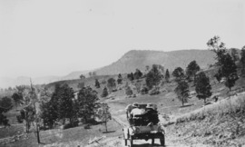
407:, flows from east to west through the locality. Mount Gipps Road enters from Chinghee Creek in the north-west and follows through the valley. Although entirely freehold land, only the lower valley areas have been cleared and are used for grazing. The slopes have an extensive tree cover.
359:
and also in the north-east with a valley through the north-west and from west to east. The mountain Mount Gipps, from which the locality takes its name, is on the southern border of the locality with New South Wales
919:
679:
91:
444:
423:
363:
232:
220:
911:
572:
1143:
1023:
667:
58:
1098:
1615:
208:
641:
321:
1639:
839:
807:
711:
775:
743:
225:
1016:
941:
538:
1503:
1333:
301:
280:
861:
415:
1418:
344:
38:
1328:
1218:
84:
1001:
1563:
1438:
1408:
1168:
1634:
1583:
1568:
1238:
1163:
1009:
637:
260:
255:
1488:
1463:
1388:
1153:
1133:
890:
272:
441:
Mount Gipps State School was opened on 21 July 1920. It closed on 30 June 1954. It was at 220 Mount Gipps Road (
1573:
1413:
1398:
1393:
1383:
1378:
1293:
1288:
886:
802:
295:
288:
1548:
1458:
1453:
1433:
1303:
1273:
1248:
1093:
1068:
706:
1593:
1513:
1498:
1473:
1443:
1428:
1268:
1233:
1228:
1223:
1203:
1178:
1088:
1073:
945:
542:
513:
497:
490:
333:
193:
152:
136:
1603:
1598:
1558:
1528:
1518:
1448:
1373:
1343:
1318:
1308:
1243:
1213:
1158:
1138:
1128:
1118:
1078:
1053:
1048:
1037:
915:
865:
738:
675:
580:
265:
508:
There are no schools in Mount Gibbs. The nearest government primary school is
Hillview State School in
1588:
1578:
1553:
1483:
1478:
1423:
1363:
1323:
1263:
1253:
1208:
1148:
1123:
1103:
1083:
770:
509:
1543:
1508:
1493:
1468:
1368:
1353:
1348:
1193:
1188:
1183:
1173:
1113:
1058:
984:
834:
616:
1538:
1523:
1358:
1338:
1313:
1283:
1278:
1108:
237:
431:
In 1900, much of the land in the upper reaches of
Running Creek was part of the rural property
1298:
1198:
1033:
325:
213:
170:
1258:
1533:
962:
559:
356:
340:
44:
512:
to the north. The nearest government secondary school is
Beaudesert State High School in
1628:
438:
There was a sawmill in Mount Gipps from at least 1920. It was located in the valley.
404:
979:
829:
797:
701:
329:
179:
29:
765:
733:
460:
446:
379:
365:
107:
93:
998:— a description of the MacPherson Ranges in 1929, including Mount Gipps area
645:
612:
199:
1063:
422:
414:
175:
1005:
573:"Mount Gipps – locality in Scenic Rim Region (entry 45173)"
400:); it rises to 785 metres (2,575 ft) above sea level.
355:
Mount Gipps has high slopes to the south belonging to the
500:, Mount Gipps had "no people or a very low population".
336:, Mount Gipps had "no people or a very low population".
638:"Information on the Darling Downs-Moreton Rabbit Board"
231:
219:
207:
186:
169:
161:
151:
143:
131:
83:
23:
18:Suburb of Scenic Rim Region, Queensland, Australia
862:"Opening and closing dates of Queensland Schools"
244:
427:Workers from the Mount Gipps Sawmill, ca. 1925
1017:
8:
533:
531:
529:
1024:
1010:
1002:
996:– via National Library of Australia.
961:
887:"Agency ID 9136, Mount Gipps State School"
850:– via National Library of Australia.
818:– via National Library of Australia.
786:– via National Library of Australia.
754:– via National Library of Australia.
742:. Brisbane. 25 November 1920. p. 16.
722:– via National Library of Australia.
558:
37:
20:
806:. Brisbane. 10 October 1919. p. 4.
702:"From Lara to Cannon and Knapp's Creek"
668:"Mountain peaks and capes - Queensland"
607:
605:
603:
601:
599:
597:
525:
912:"Queensland Two Mile series sheet 2m4"
838:. Brisbane. 4 June 1920. p. 23.
682:from the original on 25 November 2020
285:
270:
253:
246:
7:
1616:Local government areas of Queensland
922:from the original on 13 January 2022
842:from the original on 13 January 2022
810:from the original on 13 January 2022
778:from the original on 13 January 2022
746:from the original on 13 January 2022
714:from the original on 13 January 2022
988:. Brisbane. 26 July 1929. p. 8
65:
642:Darling Downs-Moreton Rabbit Board
403:Running Creek, a tributary of the
165:15.7 km (6.1 sq mi)
14:
644:. 28 January 2015. Archived from
472:Mount Gipps State School (former)
119:Mount Gipps (centre of locality)
64:
57:
942:Australian Bureau of Statistics
539:Australian Bureau of Statistics
192:42.8 km (27 mi) S of
343: and is one end of the
198:112 km (70 mi) S of
1:
419:Mount Gipps Sawmill, ca. 1925
345:Queensland rabbit-proof fence
1032:Towns and localities in the
710:. 25 June 1900. p. 18.
774:. 27 June 1922. p. 7.
249:Suburbs around Mount Gipps:
1656:
830:"THE WEEK'S NEWS IN BRIEF"
1612:
1044:
891:Queensland State Archives
307:
247:
243:
147:0.00/km (0.00/sq mi)
52:
36:
1640:Localities in Queensland
734:"Meeting at Mount Gipps"
707:Queensland Country Life
950:2016 Census QuickStats
577:Queensland Place Names
547:2021 Census QuickStats
428:
420:
1038:South East Queensland
916:Queensland Government
866:Queensland Government
676:Queensland Government
581:Queensland Government
426:
418:
339:The locality borders
771:The Brisbane Courier
678:. 12 November 2020.
672:Queensland Open Data
461:28.3220°S 152.9915°E
435:owned by A. Drynan.
380:28.3419°S 152.9903°E
332:, Australia. In the
108:28.3222°S 153.0097°E
946:"Mount Gipps (SSC)"
648:on 26 February 2015
617:State of Queensland
543:"Mount Gipps (SAL)"
456: /
375: /
233:Federal division(s)
221:State electorate(s)
103: /
1524:Tamborine Mountain
1504:Southern Lamington
1334:Lower Mount Walker
980:"Macpherson Range"
613:"Queensland Globe"
466:-28.3220; 152.9915
429:
421:
385:-28.3419; 152.9903
302:Southern Lamington
281:Southern Lamington
113:-28.3222; 153.0097
1635:Scenic Rim Region
1622:
1621:
1419:Mount Walker West
1034:Scenic Rim Region
326:Scenic Rim Region
315:
314:
311:
310:
214:Scenic Rim Region
1647:
1329:Limestone Ridges
1219:Fassifern Valley
1026:
1019:
1012:
1003:
997:
995:
993:
966:
965:
960:
958:
956:
944:(27 June 2017).
938:
932:
931:
929:
927:
908:
902:
901:
899:
897:
883:
877:
876:
874:
872:
858:
852:
851:
849:
847:
826:
820:
819:
817:
815:
794:
788:
787:
785:
783:
762:
756:
755:
753:
751:
730:
724:
723:
721:
719:
698:
692:
691:
689:
687:
664:
658:
657:
655:
653:
634:
628:
627:
625:
623:
609:
592:
591:
589:
587:
569:
563:
562:
557:
555:
553:
541:(28 June 2022).
535:
480:
479:
477:
476:
475:
473:
468:
467:
462:
457:
454:
453:
452:
449:
433:Telemon Crossing
399:
398:
396:
395:
394:
392:
387:
386:
381:
376:
373:
372:
371:
368:
245:
127:
126:
124:
123:
122:
120:
115:
114:
109:
104:
101:
100:
99:
96:
68:
67:
61:
41:
32:
26:
21:
1655:
1654:
1650:
1649:
1648:
1646:
1645:
1644:
1625:
1624:
1623:
1618:
1608:
1564:Veresdale Scrub
1534:Tamrookum Creek
1439:North Tamborine
1169:Christmas Creek
1040:
1030:
991:
989:
978:
975:
970:
969:
954:
952:
940:
939:
935:
925:
923:
910:
909:
905:
895:
893:
885:
884:
880:
870:
868:
860:
859:
855:
845:
843:
828:
827:
823:
813:
811:
796:
795:
791:
781:
779:
766:"AT BEAUDESERT"
764:
763:
759:
749:
747:
732:
731:
727:
717:
715:
700:
699:
695:
685:
683:
666:
665:
661:
651:
649:
636:
635:
631:
621:
619:
611:
610:
595:
585:
583:
571:
570:
566:
551:
549:
537:
536:
527:
522:
516:further north.
506:
487:
471:
469:
465:
463:
459:
458:
455:
450:
447:
445:
443:
442:
413:
390:
388:
384:
382:
378:
377:
374:
369:
366:
364:
362:
361:
357:McPherson Range
353:
341:New South Wales
144: • Density
118:
116:
112:
110:
106:
105:
102:
97:
94:
92:
90:
89:
79:
78:
77:
76:
75:
74:
73:
69:
48:
45:McPherson Range
43:Mount Gipps on
28:
27:
24:
19:
12:
11:
5:
1653:
1651:
1643:
1642:
1637:
1627:
1626:
1620:
1619:
1614:Main article:
1613:
1610:
1609:
1607:
1606:
1601:
1596:
1591:
1586:
1584:Wilsons Plains
1581:
1576:
1571:
1569:Wallaces Creek
1566:
1561:
1556:
1551:
1546:
1541:
1536:
1531:
1526:
1521:
1516:
1511:
1506:
1501:
1496:
1491:
1486:
1481:
1476:
1471:
1466:
1461:
1456:
1451:
1446:
1441:
1436:
1431:
1426:
1421:
1416:
1411:
1409:Mount Lindesay
1406:
1401:
1396:
1391:
1386:
1381:
1376:
1371:
1366:
1361:
1356:
1351:
1346:
1341:
1336:
1331:
1326:
1321:
1316:
1311:
1306:
1301:
1296:
1291:
1286:
1281:
1276:
1271:
1266:
1261:
1256:
1251:
1246:
1241:
1239:Frenches Creek
1236:
1231:
1226:
1221:
1216:
1211:
1206:
1201:
1196:
1191:
1186:
1181:
1176:
1171:
1166:
1164:Chinghee Creek
1161:
1156:
1151:
1146:
1141:
1136:
1131:
1126:
1121:
1116:
1111:
1106:
1101:
1096:
1091:
1086:
1081:
1076:
1071:
1066:
1061:
1056:
1051:
1045:
1042:
1041:
1031:
1029:
1028:
1021:
1014:
1006:
1000:
999:
974:
973:External links
971:
968:
967:
933:
903:
878:
853:
821:
798:"Public Works"
789:
757:
725:
693:
659:
629:
593:
564:
524:
523:
521:
518:
505:
502:
486:
483:
412:
409:
352:
349:
313:
312:
309:
308:
305:
304:
299:
292:
284:
283:
278:
275:
269:
268:
263:
261:Chinghee Creek
258:
256:Chinghee Creek
252:
251:
241:
240:
235:
229:
228:
223:
217:
216:
211:
205:
204:
203:
202:
196:
188:
184:
183:
173:
167:
166:
163:
159:
158:
155:
149:
148:
145:
141:
140:
133:
129:
128:
87:
81:
80:
71:
70:
63:
62:
56:
55:
54:
53:
50:
49:
42:
34:
33:
17:
13:
10:
9:
6:
4:
3:
2:
1652:
1641:
1638:
1636:
1633:
1632:
1630:
1617:
1611:
1605:
1602:
1600:
1597:
1595:
1592:
1590:
1587:
1585:
1582:
1580:
1577:
1575:
1572:
1570:
1567:
1565:
1562:
1560:
1557:
1555:
1552:
1550:
1547:
1545:
1542:
1540:
1537:
1535:
1532:
1530:
1527:
1525:
1522:
1520:
1517:
1515:
1512:
1510:
1507:
1505:
1502:
1500:
1497:
1495:
1492:
1490:
1489:Running Creek
1487:
1485:
1482:
1480:
1477:
1475:
1472:
1470:
1467:
1465:
1464:Peak Crossing
1462:
1460:
1457:
1455:
1452:
1450:
1447:
1445:
1442:
1440:
1437:
1435:
1432:
1430:
1427:
1425:
1422:
1420:
1417:
1415:
1412:
1410:
1407:
1405:
1402:
1400:
1397:
1395:
1392:
1390:
1389:Mount Edwards
1387:
1385:
1382:
1380:
1377:
1375:
1372:
1370:
1367:
1365:
1362:
1360:
1357:
1355:
1352:
1350:
1347:
1345:
1342:
1340:
1337:
1335:
1332:
1330:
1327:
1325:
1322:
1320:
1317:
1315:
1312:
1310:
1307:
1305:
1302:
1300:
1297:
1295:
1292:
1290:
1287:
1285:
1282:
1280:
1277:
1275:
1272:
1270:
1267:
1265:
1262:
1260:
1257:
1255:
1252:
1250:
1247:
1245:
1242:
1240:
1237:
1235:
1232:
1230:
1227:
1225:
1222:
1220:
1217:
1215:
1212:
1210:
1207:
1205:
1202:
1200:
1197:
1195:
1192:
1190:
1187:
1185:
1182:
1180:
1177:
1175:
1172:
1170:
1167:
1165:
1162:
1160:
1157:
1155:
1154:Carneys Creek
1152:
1150:
1147:
1145:
1142:
1140:
1137:
1135:
1134:Burnett Creek
1132:
1130:
1127:
1125:
1122:
1120:
1117:
1115:
1112:
1110:
1107:
1105:
1102:
1100:
1097:
1095:
1092:
1090:
1087:
1085:
1082:
1080:
1077:
1075:
1072:
1070:
1067:
1065:
1062:
1060:
1057:
1055:
1052:
1050:
1047:
1046:
1043:
1039:
1035:
1027:
1022:
1020:
1015:
1013:
1008:
1007:
1004:
987:
986:
981:
977:
976:
972:
964:
951:
947:
943:
937:
934:
921:
917:
913:
907:
904:
892:
888:
882:
879:
867:
863:
857:
854:
841:
837:
836:
831:
825:
822:
809:
805:
804:
803:The Telegraph
799:
793:
790:
777:
773:
772:
767:
761:
758:
745:
741:
740:
735:
729:
726:
713:
709:
708:
703:
697:
694:
681:
677:
673:
669:
663:
660:
647:
643:
639:
633:
630:
618:
614:
608:
606:
604:
602:
600:
598:
594:
582:
578:
574:
568:
565:
561:
548:
544:
540:
534:
532:
530:
526:
519:
517:
515:
511:
503:
501:
499:
494:
492:
484:
482:
478:
439:
436:
434:
425:
417:
410:
408:
406:
401:
397:
358:
350:
348:
346:
342:
337:
335:
331:
327:
323:
319:
306:
303:
300:
298:
297:
296:Cougall (NSW)
293:
291:
290:
289:Cougall (NSW)
286:
282:
279:
276:
274:
273:Running Creek
271:
267:
264:
262:
259:
257:
254:
250:
242:
239:
236:
234:
230:
227:
224:
222:
218:
215:
212:
210:
206:
201:
197:
195:
191:
190:
189:
185:
181:
177:
174:
172:
168:
164:
160:
156:
154:
150:
146:
142:
138:
134:
130:
125:
88:
86:
82:
60:
51:
46:
40:
35:
31:
22:
16:
1574:Warrill View
1414:Mount Walker
1403:
1399:Mount French
1394:Mount Forbes
1384:Mount Barney
1379:Mount Alford
1294:Kents Pocket
1289:Kents Lagoon
1144:Cannon Creek
990:. Retrieved
983:
953:. Retrieved
949:
936:
924:. Retrieved
906:
894:. Retrieved
881:
869:. Retrieved
856:
844:. Retrieved
833:
824:
812:. Retrieved
801:
792:
780:. Retrieved
769:
760:
748:. Retrieved
737:
728:
716:. Retrieved
705:
696:
684:. Retrieved
671:
662:
650:. Retrieved
646:the original
632:
620:. Retrieved
584:. Retrieved
576:
567:
550:. Retrieved
546:
507:
495:
488:
485:Demographics
440:
437:
432:
430:
402:
354:
338:
317:
316:
294:
287:
248:
15:
1549:Teviotville
1459:Palen Creek
1434:Nindooinbah
1404:Mount Gipps
1304:Knapp Creek
1274:Josephville
1249:Harrisville
1094:Binna Burra
1069:Barney View
686:25 November
586:29 December
552:28 February
498:2021 census
491:2016 census
464: /
451:152°59′29″E
405:Logan River
391:Mount Gipps
383: /
370:152°59′25″E
334:2021 census
320:is a rural
318:Mount Gipps
277:Mount Gipps
153:Postcode(s)
137:2021 census
111: /
98:153°00′35″E
85:Coordinates
72:Mount Gipps
25:Mount Gipps
1629:Categories
1594:Wonglepong
1514:Tabragalba
1499:Silverdale
1474:Rathdowney
1444:Oaky Creek
1429:Mutdapilly
1269:Innisplain
1234:Frazerview
1229:Flying Fox
1224:Ferny Glen
1204:Darlington
1179:Coleyville
1089:Biddaddaba
1074:Beaudesert
955:20 October
926:13 January
739:The Worker
520:References
514:Beaudesert
470: (
448:28°19′19″S
389: (
367:28°20′31″S
330:Queensland
226:Scenic Rim
194:Beaudesert
132:Population
117: (
95:28°19′20″S
30:Queensland
1604:Wyaralong
1599:Woolooman
1559:Veresdale
1529:Tamrookum
1519:Tamborine
1449:Obum Obum
1374:Morwincha
1344:Merryvale
1319:Lamington
1309:Kooralbyn
1244:Gleneagle
1214:Fassifern
1159:Charlwood
1139:Cainbable
1129:Bunjurgen
1119:Bromelton
1079:Beechmont
1054:Allenview
1049:Allandale
992:26 August
896:26 August
871:26 August
846:26 August
814:26 August
782:26 August
750:26 August
718:26 August
652:21 August
504:Education
351:Geography
266:Lamington
180:UTC+10:00
171:Time zone
1589:Witheren
1579:Washpool
1554:Undullah
1484:Rosevale
1479:Roadvale
1454:O'Reilly
1424:Munbilla
1364:Moogerah
1324:Laravale
1264:Illinbah
1254:Hillview
1209:Dugandan
1149:Canungra
1124:Bunburra
1104:Blantyre
1084:Benobble
985:The Week
920:Archived
918:. 1946.
840:Archived
835:The Week
808:Archived
776:Archived
744:Archived
712:Archived
680:Archived
510:Hillview
322:locality
200:Brisbane
187:Location
135:0 (
1544:Templin
1509:Tabooba
1494:Sarabah
1469:Radford
1369:Moorang
1354:Milford
1349:Milbong
1194:Croftby
1189:Coulson
1184:Coochin
1174:Clumber
1114:Boyland
1064:Aratula
1059:Anthony
914:(Map).
496:In the
489:In the
411:History
324:in the
1539:Tarome
1359:Milora
1339:Maroon
1314:Kulgun
1284:Kalbar
1279:Kagaru
1109:Boonah
1099:Birnam
238:Wright
209:LGA(s)
47:, 1928
1299:Kerry
1199:Cryna
622:4 May
1259:Hoya
994:2015
957:2018
928:2022
898:2015
873:2015
848:2015
816:2015
784:2015
752:2015
720:2015
688:2020
654:2015
624:2020
588:2020
554:2023
176:AEST
162:Area
157:4285
481:).
1631::
1036:,
982:.
948:.
889:.
864:.
832:.
800:.
768:.
736:.
704:.
674:.
670:.
640:.
615:.
596:^
579:.
575:.
545:.
528:^
347:.
328:,
1025:e
1018:t
1011:v
959:.
930:.
900:.
875:.
690:.
656:.
626:.
590:.
556:.
474:)
393:)
360:(
182:)
178:(
139:)
121:)
Text is available under the Creative Commons Attribution-ShareAlike License. Additional terms may apply.