170:
304:
131:
177:
138:
1338:
316:
29:
1315:
296:
triggered by the eruption. The next day, new activity forced police to suspend search operations. One month after the eruption, it was announced by prefectural officials that only the summit of the volcano was off limits to the public.
169:
636:
1303:
303:
130:
629:
1375:
501:
414:
1419:
1394:
622:
356:
61:
1319:
1195:
594:
526:
1429:
552:
1399:
1434:
1409:
688:
646:
1368:
1308:
54:
1032:
693:
584:
220:
315:
1414:
683:
337:
332:
1404:
1250:
1424:
449:
1173:
1107:
1361:
795:
454:
997:
868:
760:
262:
208:
790:
678:
422:
883:
730:
717:
278:
474:
1235:
1012:
605:
1280:
366:
1337:
1245:
1092:
992:
830:
735:
289:
109:
1345:
1185:
943:
918:
800:
713:
274:
266:
1285:
1275:
1255:
1190:
845:
840:
745:
698:
1298:
1112:
963:
855:
750:
1240:
1205:
1178:
1132:
1072:
1062:
1052:
1037:
982:
972:
938:
923:
820:
805:
703:
560:
254:
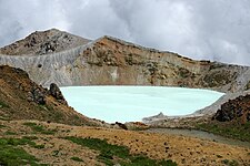
281:. The largest of these is Yu-gama, an acidic emerald green lake with rafts of yellow
1388:
1260:
1210:
1137:
1102:
1022:
1007:
928:
913:
908:
898:
780:
663:
213:
1168:
1147:
1142:
1127:
1077:
1017:
863:
835:
810:
785:
755:
765:
28:
388:
1230:
987:
953:
933:
903:
888:
878:
825:
775:
740:
725:
673:
668:
614:
270:
444:
1265:
1200:
1163:
1122:
1117:
1047:
1042:
1027:
1002:
948:
873:
770:
292:
of the volcano occurred. One person was killed, and others were injured in an
76:
63:
1270:
1082:
815:
293:
150:
655:
595:"Kusatsu-Shiranesan: National catalogue of the active volcanoes in Japan"
269:. The summit of Kusatsu-Shirane volcano, located immediately north of
250:
282:
44:
258:
154:
421:. Bureau of Tourism, GUNMA Prefectural Government. Archived from
618:
502:"Japan: fatal avalanche engulfs skiers after volcano erupts"
261:. It is called Kusatsu Shirane to differentiate it from the
475:"Mt. Kusatsu-Shirane saw repeated eruptions in the past"
1349:
1223:
1156:
1091:
1061:
971:
962:
854:
712:
654:
219:
207:
202:
117:
97:
92:
53:
43:
38:
21:
553:"One month since eruption of Mt. Kusatsu-Shirane"
527:"Volcanic tremors halt search ops after eruption"
33:View of Mount Kusatsu-Shirane from the southeast
242:
236:
101:
1369:
630:
176:
137:
8:
1344:This Gunma Prefecture location article is a
16:Stratovolcano on the island of Honshu, Japan
1376:
1362:
968:
637:
623:
615:
481:. The Mainichi Newspapers. 24 January 2018
18:
249:is a 2,165 m (7,103 ft) active
285:sometimes seen floating on its surface.
559:. NHK. 23 February 2018. Archived from
348:
299:
273:, consists of a series of overlapping
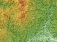
309:Relief map of Kusatsu-Shirane Volcano
7:
1334:
1332:
1314:
1348:. You can help Knowledge (XXG) by
365:(in Japanese). NHK. Archived from
14:
1336:
1313:
314:
302:
175:
168:
136:
129:
27:
587:- Japan Meteorological Agency
1:
1420:Volcanoes of Gunma Prefecture
1395:Mountains of Gunma Prefecture
1320:100 Famous Japanese Mountains
647:100 Famous Japanese Mountains
602:- Japan Meteorological Agency
393:OSU Department of Geosciences
288:On January 23, 2018, a minor
189:Mount Kusatsu-Shirane (Japan)
1309:Three-thousanders (in Japan)
608:- Geological Survey of Japan
49:2,165 m (7,103 ft)
243:
1451:
1331:
1304:List of mountains in Japan
338:List of mountains in Japan
333:List of volcanoes in Japan
1294:
395:. Oregon State University
237:
159:Show map of Central Japan
122:
102:
26:
1430:Stratovolcanoes of Japan
796:Mt. Echigo (Uonuma-Koma)
450:Global Volcanism Program
415:"Mt. Kusatsu-Shiranesan"
357:
606:Kusatsu-Shirane Volcano
455:Smithsonian Institution
533:. AFP. 24 January 2018
1435:Gunma geography stubs
1410:Volcanic crater lakes
265:on the other side of
232:Mount Kusatsu-Shirane
183:Mount Kusatsu-Shirane
144:Mount Kusatsu-Shirane
22:Mount Kusatsu-Shirane
1322:at Wikimedia Commons
445:"Kusatsu-Shiranesan"
358:草津白根山が噴火 警戒レベル3に 気象庁
77:36.6438°N 138.5279°E
1400:Volcanoes of Honshū
894:Mt. Kusatsu-Shirane
563:on 24 February 2018
419:Gunma Tourist Guide
263:Mount Nikkō-Shirane
244:Kusatsu Shirane-san
73: /
1261:Mt. Kujū (Kokonoe)
585:Kusatsu-Shiranesan
425:on 25 January 2018
369:on 23 January 2018
39:Highest point
1415:Complex volcanoes
1357:
1356:
1329:
1328:
1318:Media related to
1219:
1218:
1093:Akaishi Mountains
1018:Mt. Kuro (Suishō)
718:Jōshinetsu region
500:McCurry, Justin.
389:"Kusatsu-Shirane"
290:phreatic eruption
275:pyroclastic cones
229:
228:
192:Show map of Japan
82:36.6438; 138.5279
1442:
1405:Active volcanoes
1378:
1371:
1364:
1340:
1333:
1317:
1316:
1182:
969:
811:Mt. Hiuchigatake
639:
632:
625:
616:
601:
599:
590:
573:
572:
570:
568:
549:
543:
542:
540:
538:
523:
517:
516:
514:
512:
497:
491:
490:
488:
486:
471:
465:
464:
462:
461:
441:
435:
434:
432:
430:
411:
405:
404:
402:
400:
385:
379:
378:
376:
374:
353:
318:
306:
267:Gunma Prefecture
248:
246:
240:
239:
225:January 23, 2018
193:
179:
178:
172:
160:
140:
139:
133:
113:
105:
104:
88:
87:
85:
84:
83:
78:
74:
71:
70:
69:
66:
31:
19:
1450:
1449:
1445:
1444:
1443:
1441:
1440:
1439:
1425:VEI-3 volcanoes
1385:
1384:
1383:
1382:
1330:
1325:
1290:
1215:
1176:
1174:Utsukushigahara
1152:
1096:(Southern Alps)
1095:
1087:
1065:
1057:
993:Mt. Kashimayari
976:(Northern Alps)
975:
958:
869:Mt. Oku-Shirane
850:
716:
708:
650:
643:
612:
597:
593:
588:
581:
576:
566:
564:
551:
550:
546:
536:
534:
525:
524:
520:
510:
508:
499:
498:
494:
484:
482:
473:
472:
468:
459:
457:
443:
442:
438:
428:
426:
413:
412:
408:
398:
396:
387:
386:
382:
372:
370:
359:
355:
354:
350:
346:
329:
322:
319:
310:
307:
234:
198:
197:
196:
195:
194:
191:
190:
187:
186:
185:
184:
180:
163:
162:
161:
158:
157:
148:
147:
146:
145:
141:
107:
81:
79:
75:
72:
67:
64:
62:
60:
59:
34:
17:
12:
11:
5:
1448:
1446:
1438:
1437:
1432:
1427:
1422:
1417:
1412:
1407:
1402:
1397:
1387:
1386:
1381:
1380:
1373:
1366:
1358:
1355:
1354:
1341:
1327:
1326:
1324:
1323:
1311:
1306:
1301:
1295:
1292:
1291:
1289:
1288:
1283:
1278:
1273:
1268:
1263:
1258:
1253:
1248:
1243:
1238:
1236:Mt. Ōdaigahara
1233:
1227:
1225:
1221:
1220:
1217:
1216:
1214:
1213:
1208:
1203:
1198:
1193:
1188:
1186:Mt. Kirigamine
1183:
1171:
1166:
1160:
1158:
1154:
1153:
1151:
1150:
1145:
1140:
1135:
1130:
1125:
1120:
1115:
1110:
1105:
1099:
1097:
1089:
1088:
1086:
1085:
1080:
1075:
1069:
1067:
1066:(Central Alps)
1063:Kiso Mountains
1059:
1058:
1056:
1055:
1050:
1045:
1040:
1035:
1030:
1025:
1020:
1015:
1013:Mt. Kurobegorō
1010:
1005:
1000:
995:
990:
985:
979:
977:
973:Hida Mountains
966:
960:
959:
957:
956:
951:
946:
944:Mt. Daibosatsu
941:
936:
931:
926:
921:
916:
911:
906:
901:
896:
891:
886:
881:
876:
871:
866:
860:
858:
852:
851:
849:
848:
843:
838:
833:
828:
823:
818:
813:
808:
803:
801:Mt. Hiragatake
798:
793:
788:
783:
778:
773:
768:
763:
758:
753:
748:
743:
738:
733:
728:
722:
720:
710:
709:
707:
706:
701:
696:
691:
689:Mt. Tomuraushi
686:
681:
676:
671:
666:
660:
658:
652:
651:
644:
642:
641:
634:
627:
619:
610:
609:
603:
591:
580:
579:External links
577:
575:
574:
544:
518:
492:
466:
436:
406:
380:
347:
345:
342:
341:
340:
335:
328:
325:
324:
323:
320:
313:
311:
308:
301:
255:Kusatsu, Gunma
227:
226:
223:
217:
216:
211:
205:
204:
200:
199:
188:
182:
181:
174:
173:
167:
166:
165:
164:
149:
143:
142:
135:
134:
128:
127:
126:
125:
124:
123:
120:
119:
115:
114:
99:
95:
94:
90:
89:
57:
51:
50:
47:
41:
40:
36:
35:
32:
24:
23:
15:
13:
10:
9:
6:
4:
3:
2:
1447:
1436:
1433:
1431:
1428:
1426:
1423:
1421:
1418:
1416:
1413:
1411:
1408:
1406:
1403:
1401:
1398:
1396:
1393:
1392:
1390:
1379:
1374:
1372:
1367:
1365:
1360:
1359:
1353:
1351:
1347:
1342:
1339:
1335:
1321:
1312:
1310:
1307:
1305:
1302:
1300:
1297:
1296:
1293:
1287:
1286:Mt. Miyanoura
1284:
1282:
1279:
1277:
1276:Mt. Kirishima
1274:
1272:
1269:
1267:
1264:
1262:
1259:
1257:
1256:Mt. Ishizuchi
1254:
1252:
1249:
1247:
1244:
1242:
1239:
1237:
1234:
1232:
1229:
1228:
1226:
1224:Western Japan
1222:
1212:
1209:
1207:
1204:
1202:
1199:
1197:
1194:
1192:
1191:Mt. Tateshina
1189:
1187:
1184:
1180:
1175:
1172:
1170:
1167:
1165:
1162:
1161:
1159:
1155:
1149:
1146:
1144:
1141:
1139:
1136:
1134:
1131:
1129:
1126:
1124:
1121:
1119:
1116:
1114:
1111:
1109:
1106:
1104:
1101:
1100:
1098:
1094:
1090:
1084:
1081:
1079:
1076:
1074:
1071:
1070:
1068:
1064:
1060:
1054:
1051:
1049:
1046:
1044:
1041:
1039:
1036:
1034:
1031:
1029:
1026:
1024:
1021:
1019:
1016:
1014:
1011:
1009:
1006:
1004:
1001:
999:
996:
994:
991:
989:
986:
984:
981:
980:
978:
974:
970:
967:
965:
961:
955:
952:
950:
947:
945:
942:
940:
937:
935:
932:
930:
927:
925:
922:
920:
917:
915:
912:
910:
907:
905:
902:
900:
897:
895:
892:
890:
887:
885:
882:
880:
877:
875:
872:
870:
867:
865:
862:
861:
859:
857:
853:
847:
846:Mt. Takatsuma
844:
842:
841:Mt. Amakazari
839:
837:
834:
832:
829:
827:
824:
822:
819:
817:
814:
812:
809:
807:
804:
802:
799:
797:
794:
792:
791:Mt. Aizu-Koma
789:
787:
784:
782:
779:
777:
774:
772:
769:
767:
764:
762:
759:
757:
754:
752:
749:
747:
746:Mt. Hayachine
744:
742:
739:
737:
734:
732:
729:
727:
724:
723:
721:
719:
715:
714:Tōhoku region
711:
705:
702:
700:
699:Mt. Poroshiri
697:
695:
692:
690:
687:
685:
682:
680:
677:
675:
672:
670:
667:
665:
662:
661:
659:
657:
653:
649:
648:
640:
635:
633:
628:
626:
621:
620:
617:
613:
607:
604:
596:
592:
589:(in Japanese)
586:
583:
582:
578:
562:
558:
554:
548:
545:
532:
528:
522:
519:
507:
503:
496:
493:
480:
476:
470:
467:
456:
452:
451:
446:
440:
437:
424:
420:
416:
410:
407:
394:
390:
384:
381:
368:
364:
360:
352:
349:
343:
339:
336:
334:
331:
330:
326:
321:Yugama crater
317:
312:
305:
300:
298:
295:
291:
286:
284:
280:
276:
272:
271:Asama volcano
268:
264:
260:
256:
252:
251:stratovolcano
245:
233:
224:
222:
221:Last eruption
218:
215:
214:Stratovolcano
212:
210:
209:Mountain type
206:
201:
171:
156:
152:
132:
121:
116:
111:
100:
96:
91:
86:
58:
56:
52:
48:
46:
42:
37:
30:
25:
20:
1350:expanding it
1343:
1299:Kyūya Fukada
1206:Mt. Arashima
1133:Mt. Warusawa
1073:Mt. Kisokoma
1053:Mt. Norikura
983:Mt. Shirouma
964:Chūbu region
939:Mt. Mizugaki
924:Mt. Kumotori
893:
856:Kantō region
821:Mt. Tanigawa
816:Mt. Shibutsu
806:Mt. Makihata
684:Mt. Taisetsu
645:
611:
565:. Retrieved
561:the original
556:
547:
535:. Retrieved
530:
521:
509:. Retrieved
506:The Guardian
505:
495:
483:. Retrieved
479:The Mainichi
478:
469:
458:. Retrieved
448:
439:
427:. Retrieved
423:the original
418:
409:
397:. Retrieved
392:
383:
371:. Retrieved
367:the original
363:NHK News Web
362:
351:
287:
279:crater lakes
231:
230:
1251:Mt. Tsurugi
1211:Mt. Azumaya
1196:Yatsugatake
1177: [
1138:Mt. Akaishi
1103:Mt. Kaikoma
1023:Mt. Washiba
1008:Mt. Yakushi
998:Mt. Tsurugi
929:Mt. Kobushi
919:Mt. Ryōkami
914:Mt. Tanzawa
909:Mt. Tsukuba
899:Mt. Azumaya
781:Mt. Adatara
736:Hachimantai
694:Mt. Tokachi
664:Mt. Rishiri
567:23 February
531:Japan Today
98:Native name
80: /
68:138°31′40″E
55:Coordinates
1389:Categories
1281:Mt. Kaimon
1169:Mt. Ontake
1148:Mt. Tekari
1143:Mt. Hijiri
1128:Mt. Shiomi
1078:Mt. Utsugi
1033:Mt. Hotaka
884:Mt. Hotaka
864:Mt. Nantai
836:Hiuchiyama
786:Mt. Bandai
756:Mt. Gassan
751:Mt. Chokai
537:24 January
511:23 January
485:24 January
460:2021-06-24
429:24 January
399:23 January
373:23 January
344:References
277:and three
65:36°38′38″N
1241:Mt. Ōmine
1231:Mt. Ibuki
1108:Mt. Senjō
1038:Mt. Jōnen
988:Mt. Goryu
954:Mt. Amagi
934:Mt. Kinpu
904:Mt. Asama
889:Mt. Akagi
879:Mt. Sukai
831:Mt. Myōkō
826:Mt. Naeba
776:Mt. Azuma
761:Mt. Asahi
741:Mt. Iwate
726:Mt. Iwaki
704:Mt. Yōtei
674:Mt. Shari
669:Mt. Rausu
557:NHK World
294:avalanche
118:Geography
45:Elevation
1266:Mt. Sobo
1201:Mt. Haku
1164:Mt. Fuji
1123:Mt. Aino
1118:Mt. Kita
1048:Mt. Yake
1043:Mt. Kasa
1028:Mt. Yari
1003:Mt. Tate
949:Mt. Fuji
874:Mt. Nasu
771:Mt. Iide
679:Mt. Akan
656:Hokkaidō
327:See also
110:Japanese
1271:Mt. Aso
1113:Mt. Hōō
1083:Mt. Ena
766:Mt. Zaō
731:Hakkōda
203:Geology
1246:Daisen
1157:Others
283:sulfur
151:Honshū
106:
93:Naming
1181:]
598:(PDF)
259:Japan
238:草津白根山
155:Japan
103:草津白根山
1346:stub
569:2018
539:2018
513:2018
487:2018
431:2018
401:2018
375:2018
253:in
1391::
1179:ja
555:.
529:.
504:.
477:.
453:.
447:.
417:.
391:.
361:.
257:,
241:,
153:,
1377:e
1370:t
1363:v
1352:.
638:e
631:t
624:v
600:.
571:.
541:.
515:.
489:.
463:.
433:.
403:.
377:.
247:)
235:(
112:)
108:(
Text is available under the Creative Commons Attribution-ShareAlike License. Additional terms may apply.