140:
147:
34:
139:
66:
468:
395:
463:
276:
259:. "Kanmuri" is a common name for mountains in Japan; Hiroshima Prefecture has six mountains by this name alone, hence the modifier "Yoshiwa".
374:
59:
392:
298:
248:
414:
272:
268:
252:
182:
159:
337:
120:
106:
419:
Nihon
Daihyakka Zensho (Nipponika) (日本大百科全書(ニッポニカ) “Large Encyclopedia of Japan (Nipponika)”)
371:
399:
378:
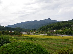
340:, also known as National Route 468, follows the southern base of Mount Yoshiwa Kanmuri.
175:
457:
287:
194:
290:, and the area is designated a natural monument by the Prefecture of Hiroshima.
81:
68:
33:
442:
244:
271:
of 1,339 m (4,393 ft). The mountain is at the far west of the
317:
283:
of the southern base of Mount
Yoshiwa Kanmuri features large stands of
280:
321:
201:
49:
256:
163:
325:
349:
422:
421:(in Japanese). Tokyo: Shogakukan. 2012. Archived from
193:
188:
174:
127:
112:
102:
97:
58:
48:
43:
21:
309:
236:
220:
303:
230:
214:
328:forests at the eastern foot of the mountain.
146:
8:
469:Tourist attractions in Hiroshima Prefecture
18:
277:Nishi-Chugoku Sanchi Quasi-National Park
364:
227:, also known as Mount Yoshiwa Kanmuri
119:
7:
247:located in the Yoshiwa District of
14:
464:Mountains of Hiroshima Prefecture
145:
138:
32:
22:Mount Kanmuri (Yoshiwa Kanmuri)
1:
267:Mount Yoshiwa Kanmuri has an
54:1,339 m (4,393 ft)
16:Mountain in Hiroshima, Japan
350:Mominoki Prefectural Forest
310:
299:Mominoki Prefectural Forest
237:
221:
485:
304:
231:
215:
132:
31:
26:
324:, and is located in the
82:34.78333°N 132.35889°E
311:Mominoki Shinrin Kōen
153:Mount Yoshiwa Kanmuri
121:[kammɯɾijama]
38:Mount Yoshiwa Kanmuri
253:Hiroshima Prefecture
238:Yoshiwa Kanmuri-yama
160:Hiroshima Prefecture
316:has facilities for
87:34.78333; 132.35889
78: /
398:2015-04-02 at the
377:2013-04-19 at the
338:Chugoku Expressway
44:Highest point
393:第1章廿日市市・大野町の現状と課題
275:, and is part of
273:Chūgoku Mountains
207:
206:
183:Chūgoku Mountains
476:
448:
447:
440:
434:
433:
431:
430:
411:
405:
404:
390:
384:
383:
369:
354:
315:
313:
307:
306:
242:
240:
234:
233:
226:
224:
218:
217:
197:
178:
149:
148:
142:
123:
118:
103:Language of name
93:
92:
90:
89:
88:
83:
79:
76:
75:
74:
71:
36:
19:
484:
483:
479:
478:
477:
475:
474:
473:
454:
453:
452:
451:
445:
441:
437:
428:
426:
413:
412:
408:
402:
400:Wayback Machine
391:
387:
381:
379:Wayback Machine
370:
366:
361:
352:
346:
334:
301:
296:
265:
228:
212:
195:
176:
170:
169:
168:
167:
166:
157:
156:
155:
154:
150:
116:
86:
84:
80:
77:
72:
69:
67:
65:
64:
39:
17:
12:
11:
5:
482:
480:
472:
471:
466:
456:
455:
450:
449:
435:
406:
385:
363:
362:
360:
357:
356:
355:
345:
344:External links
342:
333:
332:Transportation
330:
295:
292:
285:renge tsutsuji
264:
261:
205:
204:
199:
191:
190:
186:
185:
180:
172:
171:
158:
152:
151:
144:
143:
137:
136:
135:
134:
133:
130:
129:
125:
124:
114:
110:
109:
104:
100:
99:
95:
94:
62:
56:
55:
52:
46:
45:
41:
40:
37:
29:
28:
24:
23:
15:
13:
10:
9:
6:
4:
3:
2:
481:
470:
467:
465:
462:
461:
459:
446:(in Japanese)
444:
439:
436:
425:on 2007-08-25
424:
420:
416:
410:
407:
403:(in Japanese)
401:
397:
394:
389:
386:
382:(in Japanese)
380:
376:
373:
368:
365:
358:
353:(in Japanese)
351:
348:
347:
343:
341:
339:
331:
329:
327:
323:
319:
312:
300:
293:
291:
289:
286:
282:
278:
274:
270:
262:
260:
258:
254:
250:
246:
239:
223:
211:
210:Mount Kanmuri
203:
200:
198:
196:Easiest route
192:
187:
184:
181:
179:
173:
165:
161:
141:
131:
126:
122:
115:
113:Pronunciation
111:
108:
105:
101:
96:
91:
63:
61:
57:
53:
51:
47:
42:
35:
30:
25:
20:
438:
427:. Retrieved
423:the original
418:
409:
388:
367:
335:
297:
288:rhododendron
284:
266:
222:Kanmuri-yama
209:
208:
177:Parent range
372:吉和冠山(1339m)
263:Description
249:Hatsukaichi
85: /
73:132°21′32″E
60:Coordinates
458:Categories
429:2012-01-12
359:References
294:Recreation
415:"Yoshiwa"
269:elevation
128:Geography
117:Japanese:
70:34°47′0″N
50:Elevation
27:冠山 (吉和冠山)
443:もみのき森林公園
396:Archived
375:Archived
305:もみのき森林公園
281:plateaus
245:mountain
189:Climbing
107:Japanese
318:camping
243:, is a
322:hiking
279:. The
202:Hiking
98:Naming
257:Japan
164:Japan
336:The
320:and
232:吉和冠山
326:fir
460::
417:.
308:,
255:,
251:,
235:,
219:,
216:冠山
162:,
432:.
314:)
302:(
241:)
229:(
225:)
213:(
Text is available under the Creative Commons Attribution-ShareAlike License. Additional terms may apply.