124:
131:
36:
457:
255:
270:
tribe legend tells an origin story of Mount Storm King being angered by fighting tribes at his feet and broke a boulder from his peak, throwing it at the warriors, killing them and cutting Tsulh-mut in two creating
80:
537:
498:
522:
329:
123:
258:
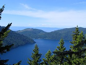
Taken June, 2006 on the summit trail. Lake
Crescent is visible in the foreground, the Strait of Juan de Fuca in the background just over seven miles distant.
517:
527:
440:
491:
243:
but branches to the north after a short distance. The first 1.9 miles (3.1 km) is on maintained trail but the rest of the climb involves
356:
333:
20:
431:
406:
484:
372:
436:
180:
325:
73:
532:
464:
143:
236:
217:
426:
221:
201:
147:
55:
63:
213:
19:
This article is about the mountain in
Clallam County, Washington. For mountains with similar names, see
248:
402:
352:
468:
317:
276:
175:
35:
240:
163:
511:
272:
225:
151:
229:
193:
456:
299:
244:
95:
82:
399:
Washington Myths and
Legends: The True Stories behind History's Mysteries
267:
48:
254:
253:
472:
373:"Our deep lakes incite curiosity and conjure legends"
192:
187:
174:
162:
111:
72:
62:
47:
42:
28:
232:, and has an elevation of 4,500+ feet (1,370+ m).
330:National Oceanic and Atmospheric Administration
224:. The mountain is located on the south side of
492:
16:Mountain in Washington (state), United States
8:
538:Clallam County, Washington geography stubs
499:
485:
25:
441:United States Department of the Interior
401:. Rowman & Littlefield. p. 59.
235:The trail to the summit starts near the
130:
523:Mountains of Clallam County, Washington
288:
351:(2nd ed.). Helena, Mont: Falcon.
239:, and initially follows the trail to
7:
453:
451:
334:United States Department of Commerce
294:
292:
432:Geographic Names Information System
518:Landforms of Olympic National Park
471:. You can help Knowledge (XXG) by
14:
455:
129:
122:
34:
528:Mountains of Washington (state)
437:United States Geological Survey
300:"Mount Storm King, Washington"
96:48.055708811°N 123.740815125°W
1:
467:state location article is a
349:Hiking Olympic National Park
101:48.055708811; -123.740815125
554:
465:Clallam County, Washington
450:
18:
237:Storm King Ranger Station
116:
33:
326:National Geodetic Survey
247:on loose rock with some
200:Mount Storm King trail,
68:750 ft (230 m)
216:about 20 miles west of
259:
212:is located within the
347:Molvar, Erik (2008).
257:
214:Olympic National Park
397:Bragg, Lynn (2015).
53:4,500+ ft (1,370+ m)
92: /
21:Storm King Mountain
427:"Mount Storm King"
260:
56: NGVD 29
43:Highest point
533:Olympic Mountains
480:
479:
377:The Seattle Times
358:978-0-7627-4119-9
207:
206:
170:Olympic Mountains
58:
545:
501:
494:
487:
459:
452:
444:
413:
412:
394:
388:
387:
385:
384:
369:
363:
362:
344:
338:
337:
314:
308:
307:
296:
210:Mount Storm King
196:
166:
137:Mount Storm King
133:
132:
126:
107:
106:
104:
103:
102:
97:
93:
90:
89:
88:
85:
54:
38:
29:Mount Storm King
26:
553:
552:
548:
547:
546:
544:
543:
542:
508:
507:
506:
505:
448:
425:
422:
417:
416:
409:
396:
395:
391:
382:
380:
371:
370:
366:
359:
346:
345:
341:
316:
315:
311:
298:
297:
290:
285:
277:Lake Sutherland
265:
194:
183:Lake Sutherland
164:
158:
157:
156:
155:
154:
141:
140:
139:
138:
134:
100:
98:
94:
91:
86:
83:
81:
79:
78:
24:
17:
12:
11:
5:
551:
549:
541:
540:
535:
530:
525:
520:
510:
509:
504:
503:
496:
489:
481:
478:
477:
460:
446:
445:
421:
420:External links
418:
415:
414:
408:978-1493016037
407:
389:
364:
357:
339:
322:NGS Data Sheet
309:
304:Peakbagger.com
287:
286:
284:
281:
264:
261:
241:Marymere Falls
205:
204:
198:
190:
189:
185:
184:
178:
172:
171:
168:
160:
159:
144:Clallam County
142:
136:
135:
128:
127:
121:
120:
119:
118:
117:
114:
113:
109:
108:
76:
70:
69:
66:
60:
59:
51:
45:
44:
40:
39:
31:
30:
15:
13:
10:
9:
6:
4:
3:
2:
550:
539:
536:
534:
531:
529:
526:
524:
521:
519:
516:
515:
513:
502:
497:
495:
490:
488:
483:
482:
476:
474:
470:
466:
461:
458:
454:
449:
442:
438:
434:
433:
428:
424:
423:
419:
410:
404:
400:
393:
390:
378:
374:
368:
365:
360:
354:
350:
343:
340:
335:
331:
327:
323:
319:
313:
310:
305:
301:
295:
293:
289:
282:
280:
278:
274:
273:Lake Crescent
269:
262:
256:
252:
250:
246:
242:
238:
233:
231:
227:
226:Lake Crescent
223:
219:
215:
211:
203:
199:
197:
195:Easiest route
191:
186:
182:
179:
177:
173:
169:
167:
161:
153:
149:
145:
125:
115:
110:
105:
77:
75:
71:
67:
65:
61:
57:
52:
50:
46:
41:
37:
32:
27:
22:
473:expanding it
462:
447:
430:
398:
392:
381:. Retrieved
379:. 2014-08-08
376:
367:
348:
342:
321:
312:
303:
266:
234:
230:Barnes Point
218:Port Angeles
209:
208:
202:class 3
165:Parent range
99: /
87:123°44′27″W
74:Coordinates
512:Categories
383:2017-01-21
283:References
245:scrambling
222:Washington
148:Washington
84:48°03′21″N
64:Prominence
112:Geography
49:Elevation
249:exposure
188:Climbing
176:Topo map
268:Klallum
405:
355:
263:Legend
463:This
318:"CON"
275:and
228:near
469:stub
403:ISBN
353:ISBN
181:USGS
152:U.S.
514::
439:,
435:.
429:.
375:.
332:,
328:,
324:.
320:.
302:.
291:^
279:.
251:.
220:,
150:,
146:,
500:e
493:t
486:v
475:.
443:.
411:.
386:.
361:.
336:.
306:.
23:.
Text is available under the Creative Commons Attribution-ShareAlike License. Additional terms may apply.