61:
737:
49:
147:
109:
127:
460:
In the CDP, the population was spread out, with 20.2% under the age of 18, 6.7% from 18 to 24, 25.8% from 25 to 44, 28.3% from 45 to 64, and 19.1% who were 65 years of age or older. The median age was 44 years. For every 100 females, there were 106.2 males. For every 100 females age 18 and over,
456:
living together, 9.3% had a female householder with no husband present, and 26.7% were non-families. 24.4% of all households were made up of individuals, and 13.5% had someone living alone who was 65 years of age or older. The average household size was 2.45 and the average family size was 2.86.
424:
of 2000, there were 761 people, 311 households, and 227 families residing in the CDP. The population density was 58.0 inhabitants per square mile (22.4/km). There were 402 housing units at an average density of 30.6 per square mile (11.8/km). The racial makeup of the CDP was 75.69%
962:
977:
464:
The median income for a household in the CDP was $ 43,750, and the median income for a family was $ 48,289. Males had a median income of $ 34,271 versus $ 34,432 for females. The
673:
480:
As of 2010, Mt. Vernon has four churches, one country store, Webster's Cove Marina, and the Mt. Vernon
Volunteer Fire Company, which celebrated its 25th anniversary in 2007.
60:
365:, the CDP has a total area of 15.9 square miles (41 km), of which 13.1 square miles (34 km) is land and 2.8 square miles (7.3 km) (17.59%) is water.
967:
481:
71:
666:
274:
48:
972:
637:
485:
849:
330:
284:
659:
504:
225:
651:
430:
559:
434:
267:
139:
802:
611:
563:
362:
316:
904:
683:
399:
312:
304:
151:
869:
262:
547:
932:
854:
817:
782:
767:
757:
705:
452:
There were 311 households, out of which 23.5% had children under the age of 18 living with them, 57.9% were
300:
39:
17:
894:
884:
812:
442:
787:
642:
939:
446:
235:
889:
839:
827:
797:
726:
438:
426:
919:
899:
879:
859:
864:
465:
468:
for the CDP was $ 19,919. About 10.2% of families and 17.3% of the population were below the
914:
909:
874:
777:
844:
792:
956:
469:
548:
U.S. Geological Survey
Geographic Names Information System: Mount Vernon, Maryland
698:
585:
119:
345:
332:
242:
221:
86:
73:
216:
472:, including 30.5% of those under age 18 and 15.8% of those age 65 or over.
453:
308:
250:
132:
421:
526:
632:
747:
716:
655:
735:
317:
607:
963:
Census-designated places in
Somerset County, Maryland
826:
766:
746:
715:
283:
273:
261:
249:
232:
215:
207:
199:
194:
186:
178:
170:
162:
157:
138:
118:
102:
30:
978:Maryland populated places on the Chesapeake Bay
311:, United States. The population was 761 at the
667:
8:
674:
660:
652:
560:"US Gazetteer files: 2010, 2000, and 1990"
449:of any race were 0.79% of the population.
372:
27:
496:
272:
248:
214:
193:
185:
156:
101:
66:
57:
45:
633:"National Register Information System"
392:
282:
260:
231:
206:
198:
177:
174:13.03 sq mi (33.74 km)
169:
166:15.65 sq mi (40.53 km)
161:
137:
117:
7:
968:Census-designated places in Maryland
638:National Register of Historic Places
486:National Register of Historic Places
441:, and 0.53% from two or more races.
16:For the Baltimore neighborhood, see
182:2.62 sq mi (6.79 km)
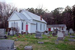
53:Grace Episcopal Church and Cemetery
682:Municipalities and communities of
586:"Census of Population and Housing"
382:
14:
145:
125:
107:
59:
47:
25:CDP in Maryland, United States
1:
507:. United States Census Bureau
973:Salisbury metropolitan area
612:United States Census Bureau
564:United States Census Bureau
505:"2020 U.S. Gazetteer Files"
363:United States Census Bureau
327:Mount Vernon is located at
211:58.42/sq mi (22.55/km)
994:
527:"Mount Vernon MD ZIP Code"
15:
928:
733:
696:
685:Somerset County, Maryland
413:
398:
391:
386:
381:
378:
358:(38.249456, −75.797422).
67:
58:
46:
37:
461:there were 105.8 males.
315:. It is included in the
529:. zipdatamaps.com. 2023
301:census-designated place
18:Mount Vernon, Baltimore
740:
482:Grace Episcopal Church
32:Mount Vernon, Maryland
739:
643:National Park Service
608:"U.S. Census website"
414:U.S. Decennial Census
374:Historical population
346:38.24944°N 75.79750°W
234: • Summer (
87:38.24944°N 75.79750°W
941:United States portal
208: • Density
190:7 ft (2 m)
566:. February 12, 2011
375:
351:38.24944; -75.79750
342: /
268:410 and 443 and 667
92:38.24944; -75.79750
83: /
741:
484:was listed on the
373:
200: • Total
179: • Water
163: • Total
950:
949:
803:Frenchtown-Rumbly
466:per capita income
418:
417:
361:According to the
294:
293:
171: • Land
985:
942:
935:
832:
770:
750:
738:
719:
708:
701:
691:
686:
676:
669:
662:
653:
647:
646:
629:
623:
622:
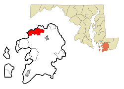
620:
618:
604:
598:
597:
595:
593:
582:
576:
575:
573:
571:
556:
550:
545:
539:
538:
536:
534:
523:
517:
516:
514:
512:
501:
431:African American
394:
389:
384:
376:
357:
356:
354:
353:
352:
347:
343:
340:
339:
338:
335:
239:
150:
149:
148:
131:
129:
128:
113:
111:
110:
98:
97:
95:
94:
93:
88:
84:
81:
80:
79:
76:
63:
51:
28:
993:
992:
988:
987:
986:
984:
983:
982:
953:
952:
951:
946:
940:
934:Maryland portal
933:
924:
905:Upper Fairmount
830:
828:
822:
768:
762:
748:
742:
736:
731:
717:
711:
706:
699:
692:
689:
684:
680:
650:
645:. July 9, 2010.
631:
630:
626:
616:
614:
606:
605:
601:
591:
589:
584:
583:
579:
569:
567:
558:
557:
553:
546:
542:
532:
530:
525:
524:
520:
510:
508:
503:
502:
498:
494:
478:
454:married couples
435:Native American
387:
371:
350:
348:
344:
341:
336:
333:
331:
329:
328:
325:
305:Somerset County
257:
233:
146:
144:
126:
124:
108:
106:
91:
89:
85:
82:
77:
74:
72:
70:
69:
54:
42:
33:
26:
21:
12:
11:
5:
991:
989:
981:
980:
975:
970:
965:
955:
954:
948:
947:
945:
944:
937:
929:
926:
925:
923:
922:
917:
912:
907:
902:
897:
892:
887:
882:
877:
872:
870:Marion Station
867:
862:
857:
852:
847:
842:
836:
834:
824:
823:
821:
820:
815:
810:
805:
800:
795:
790:
785:
780:
774:
772:
764:
763:
761:
760:
754:
752:
744:
743:
734:
732:
730:
729:
723:
721:
713:
712:
697:
694:
693:
681:
679:
678:
671:
664:
656:
649:
648:
624:
599:
577:
551:
540:
518:
495:
493:
490:
477:
474:
416:
415:
411:
410:
407:
405:
402:
396:
395:
390:
385:
380:
370:
367:
324:
321:
292:
291:
288:
281:
280:
277:
271:
270:
265:
259:
258:
255:
253:
247:
246:
240:
230:
229:
219:
213:
212:
209:
205:
204:
201:
197:
196:
192:
191:
188:
184:
183:
180:
176:
175:
172:
168:
167:
164:
160:
159:
155:
154:
142:
136:
135:
122:
116:
115:
104:
100:
99:
65:
64:
56:
55:
52:
44:
43:
38:
35:
34:
31:
24:
13:
10:
9:
6:
4:
3:
2:
990:
979:
976:
974:
971:
969:
966:
964:
961:
960:
958:
943:
938:
936:
931:
930:
927:
921:
918:
916:
913:
911:
908:
906:
903:
901:
898:
896:
893:
891:
888:
886:
883:
881:
878:
876:
873:
871:
868:
866:
863:
861:
858:
856:
855:Hudson Corner
853:
851:
848:
846:
843:
841:
838:
837:
835:
833:
825:
819:
818:West Pocomoke
816:
814:
811:
809:
806:
804:
801:
799:
796:
794:
791:
789:
786:
784:
783:Dames Quarter
781:
779:
776:
775:
773:
771:
765:
759:
758:Princess Anne
756:
755:
753:
751:
745:
728:
725:
724:
722:
720:
714:
710:
709:
707:Princess Anne
702:
695:
690:United States
687:
677:
672:
670:
665:
663:
658:
657:
654:
644:
640:
639:
634:
628:
625:
613:
609:
603:
600:
587:
581:
578:
565:
561:
555:
552:
549:
544:
541:
528:
522:
519:
506:
500:
497:
491:
489:
487:
483:
475:
473:
471:
467:
462:
458:
455:
450:
448:
444:
440:
436:
432:
428:
423:
412:
408:
406:
403:
401:
397:
377:
368:
366:
364:
359:
355:
322:
320:
318:
314:
310:
306:
302:
298:
289:
286:
278:
276:
269:
266:
264:
254:
252:
244:
241:
237:
227:
226:Eastern (EST)
223:
220:
218:
210:
202:
189:
181:
173:
165:
153:
143:
141:
134:
123:
121:
114:United States
105:
96:
68:Coordinates:
62:
50:
41:
36:
29:
23:
19:
895:Tulls Corner
885:Rhodes Point
813:Smith Island
808:Mount Vernon
807:
704:
636:
627:
615:. Retrieved
602:
590:. Retrieved
588:. Census.gov
580:
568:. Retrieved
554:
543:
531:. Retrieved
521:
509:. Retrieved
499:
479:
470:poverty line
463:
459:
451:
419:
369:Demographics
360:
326:
297:Mount Vernon
296:
295:
263:Area code(s)
22:
831:communities
788:Deal Island
700:County seat
617:January 31,
349: /
313:2000 census
90: /
957:Categories
492:References
420:As of the
337:75°47′51″W
334:38°14′58″N
287:feature ID
195:Population
78:75°47′51″W
75:38°14′58″N
890:Shelltown
840:Cokesbury
798:Fairmount
727:Crisfield
570:April 23,
533:April 18,
511:April 26,
488:in 1990.
476:Community
429:, 23.26%
323:Geography
303:(CDP) in
275:FIPS code
217:Time zone
187:Elevation
920:Westover
900:Tylerton
880:Rehobeth
860:Kingston
850:Hopewell
443:Hispanic
437:, 0.13%
433:, 0.39%
309:Maryland
279:24-54375
251:ZIP code
152:Somerset
133:Maryland
865:Manokin
592:June 4,
290:0590845
103:Country
915:Wenona
910:Venton
875:Oriole
778:Chance
447:Latino
422:census
379:Census
140:County
130:
112:
845:Ewell
829:Other
439:Asian
427:White
299:is a
256:21853
245:(EDT)
243:UTC−4
222:UTC−5
120:State
793:Eden
769:CDPs
749:Town
718:City
619:2008
594:2016
572:2011
535:2023
513:2022
400:2020
388:Note
383:Pop.
285:GNIS
158:Area
445:or
404:761
236:DST
203:761
40:CDP
959::
703::
688:,
641:.
635:.
610:.
562:.
393:%±
319:.
307:,
675:e
668:t
661:v
621:.
596:.
574:.
537:.
515:.
409:—
238:)
228:)
224:(
20:.
Text is available under the Creative Commons Attribution-ShareAlike License. Additional terms may apply.