156:
474:
459:
489:
163:
504:
34:
1425:
524:
388:
Mount Yake is the most active of all the volcanoes in the Hida
Mountains. Its two main peaks are the northern and southern peaks, but visitors can only ascend to the northern peak, as the southern peak is currently a restricted area. A
473:
746:
155:
1413:
67:
739:
1486:
1471:
458:
1476:
732:
1481:
1466:
488:
528:
89:
1429:
1305:
675:
445:
on Mount Yake, leading to the death of four people. Later explorations have shown that Mount
Akandana is an independent volcano.
1451:
798:
713:
214:
756:
534:
377:
1418:
82:
1142:
803:
465:
296:
793:
622:
72:
1461:
1360:
647:
588:
503:
1283:
1217:
1456:
905:
703:
652:
593:
430:
In 1962, there was an eruption that killed two people staying at a small hut near the mouth of the volcano.
1107:
978:
870:
267:
1003:
900:
788:
993:
840:
827:
479:
390:
195:
434:
1345:
1122:
254:
642:
1390:
424:
280:
59:
437:, which was thought to be part of Mount Yake. At 2:25pm on February 11, the workers encountered
433:
In 1995, a tunnel was being constructed on the Nagano
Prefecture side of the mountain, through
1355:
1202:
1102:
940:
845:
618:
442:
361:
357:
228:
204:
137:
679:
1295:
1053:
1028:
910:
823:
416:
260:
1395:
1385:
1365:
1300:
955:
950:
855:
808:
369:
200:
1408:
1222:
1073:
965:
860:
554:
1350:
1315:
1288:
1242:
1182:
1172:
1162:
1147:
1092:
1082:
1048:
1033:
930:
915:
813:
365:
353:
242:
235:
224:
1445:
1370:
1320:
1247:
1212:
1132:
1117:
1038:
1023:
1018:
1008:
890:
773:
400:
flowing from the upper regions of Mount Yake has led to the build up of a lava dome.
273:
1278:
1257:
1252:
1237:
1187:
1127:
973:
945:
920:
895:
865:
495:
438:
311:
875:
1340:
1097:
1063:
1043:
1013:
998:
988:
935:
885:
850:
835:
783:
778:
724:
420:
583:
1375:
1310:
1273:
1232:
1227:
1152:
1137:
1112:
1058:
983:
880:
33:
678:(in Japanese). Ministry of Land, Infrastructure and Transport. Archived from
104:
91:
1380:
1192:
925:
523:
765:
449:
285:
419:, however, there was a major eruption. The flow of the lava blocked the
349:
427:. The Azusa River is again flowing today, but the lake still remains.
509:
318:
289:
49:
415:
In 1911, 22 minor eruptions were recorded. In 1915, during the
404:
373:
188:
397:
728:
714:"Yakedake: National catalogue of the active volcanoes in Japan"
380:, reaching 2,455 m (8,054 ft) at the highest peak.
423:, which caused the river to form a lake that was named
1333:
1266:
1201:
1171:
1081:
1072:
964:
822:
764:
310:
305:
295:
279:
266:
253:
248:
234:
220:
210:
194:
184:
143:
133:
125:
120:
81:
58:
48:
43:
21:
337:
331:
740:
16:Active volcano on the island of Honshu, Japan
8:
1078:
747:
733:
725:
18:
676:"Mount Yake Volcano Disaster Prevention"
403:The heat from the volcano produces many
546:
482:between the northern and southern peaks
454:
670:
668:
613:
611:
609:
578:
576:
574:
7:
1424:
441:, which were quickly followed by a
162:
14:
1423:
522:
502:
487:
472:
457:
161:
154:
32:
555:"Topographic map of Mount Yake"
1487:Volcanoes of Nagano Prefecture
1472:Mountains of Nagano Prefecture
706:- Japan Meteorological Agency
1:
1430:100 Famous Japanese Mountains
757:100 Famous Japanese Mountains
721:- Japan Meteorological Agency
643:"Yakedake (Eruption History)"
535:100 Famous Japanese Mountains
378:100 Famous Japanese Mountains
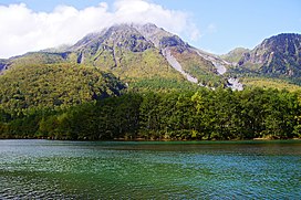
38:Mount Yake behind Lake Taishō
1482:Volcanoes of Gifu Prefecture
1467:Mountains of Gifu Prefecture
1419:Three-thousanders (in Japan)
393:lies between the two peaks.
54:2,455 m (8,054 ft)
1477:Chūbu-Sangaku National Park
529:Mount Yake (Hida Mountains)
338:
215:Chūbu-Sangaku National Park
1503:
1414:List of mountains in Japan
623:Geological Survey of Japan
452:near the mountain's peak.
1404:
448:There is still an active
407:in the surrounding area.
332:
148:
31:
26:
906:Mt. Echigo (Uonuma-Koma)
648:Global Volcanism Program
589:Global Volcanism Program
653:Smithsonian Institution
594:Smithsonian Institution
1432:at Wikimedia Commons
531:at Wikimedia Commons
1452:Volcanoes of Honshū
1004:Mt. Kusatsu-Shirane
376:. It is one of the
211:Protected area
126:English translation
101: /
1371:Mt. Kujū (Kokonoe)
494:northern peak and
346:"Burning mountain"
105:36.227°N 137.587°E
73:Volcanoes in Japan
68:Mountains in Japan
44:Highest point
1439:
1438:
1428:Media related to
1329:
1328:
1203:Akaishi Mountains
1128:Mt. Kuro (Suishō)
828:Jōshinetsu region
527:Media related to
443:phreatic eruption
362:Nagano Prefecture
324:
323:
301:February 11, 1995
175:Location in Japan
1494:
1462:Active volcanoes
1427:
1426:
1292:
1079:
921:Mt. Hiuchigatake
749:
742:
735:
726:
720:
718:
709:
691:
690:
688:
687:
672:
663:
662:
660:
659:
639:
633:
632:
630:
629:
615:
604:
603:
601:
600:
580:
569:
568:
566:
565:
551:
526:
506:
491:
476:
461:
356:, lying between
343:
341:
335:
334:
314:
261:Late Pleistocene
238:
165:
164:
158:
134:Language of name
116:
115:
113:
112:
111:
106:
102:
99:
98:
97:
94:
36:
19:
1502:
1501:
1497:
1496:
1495:
1493:
1492:
1491:
1442:
1441:
1440:
1435:
1400:
1325:
1286:
1284:Utsukushigahara
1262:
1206:(Southern Alps)
1205:
1197:
1175:
1167:
1103:Mt. Kashimayari
1086:(Northern Alps)
1085:
1068:
979:Mt. Oku-Shirane
960:
826:
818:
760:
753:
716:
712:
707:
700:
695:
694:
685:
683:
674:
673:
666:
657:
655:
641:
640:
636:
627:
625:
617:
616:
607:
598:
596:
582:
581:
572:
563:
561:
559:opentopomap.org
553:
552:
548:
543:
519:
512:
507:
498:
492:
483:
477:
468:
462:
413:
396:High viscosity
386:
370:Gifu Prefecture
329:
312:
236:
180:
179:
178:
177:
176:
173:
172:
171:
170:
166:
110:36.227; 137.587
109:
107:
103:
100:
95:
92:
90:
88:
87:
77:
39:
17:
12:
11:
5:
1500:
1498:
1490:
1489:
1484:
1479:
1474:
1469:
1464:
1459:
1457:Hida Mountains
1454:
1444:
1443:
1437:
1436:
1434:
1433:
1421:
1416:
1411:
1405:
1402:
1401:
1399:
1398:
1393:
1388:
1383:
1378:
1373:
1368:
1363:
1358:
1353:
1348:
1346:Mt. Ōdaigahara
1343:
1337:
1335:
1331:
1330:
1327:
1326:
1324:
1323:
1318:
1313:
1308:
1303:
1298:
1296:Mt. Kirigamine
1293:
1281:
1276:
1270:
1268:
1264:
1263:
1261:
1260:
1255:
1250:
1245:
1240:
1235:
1230:
1225:
1220:
1215:
1209:
1207:
1199:
1198:
1196:
1195:
1190:
1185:
1179:
1177:
1176:(Central Alps)
1173:Kiso Mountains
1169:
1168:
1166:
1165:
1160:
1155:
1150:
1145:
1140:
1135:
1130:
1125:
1123:Mt. Kurobegorō
1120:
1115:
1110:
1105:
1100:
1095:
1089:
1087:
1083:Hida Mountains
1076:
1070:
1069:
1067:
1066:
1061:
1056:
1054:Mt. Daibosatsu
1051:
1046:
1041:
1036:
1031:
1026:
1021:
1016:
1011:
1006:
1001:
996:
991:
986:
981:
976:
970:
968:
962:
961:
959:
958:
953:
948:
943:
938:
933:
928:
923:
918:
913:
911:Mt. Hiragatake
908:
903:
898:
893:
888:
883:
878:
873:
868:
863:
858:
853:
848:
843:
838:
832:
830:
820:
819:
817:
816:
811:
806:
801:
799:Mt. Tomuraushi
796:
791:
786:
781:
776:
770:
768:
762:
761:
754:
752:
751:
744:
737:
729:
723:
722:
710:
699:
698:External links
696:
693:
692:
664:
634:
605:
570:
545:
544:
542:
539:
538:
537:
532:
518:
515:
514:
513:
508:
501:
499:
496:volcanic gases
493:
486:
484:
478:
471:
469:
463:
456:
439:volcanic gases
435:Mount Akandana
412:
409:
385:
382:
354:Hida Mountains
322:
321:
316:
308:
307:
303:
302:
299:
293:
292:
283:
277:
276:
270:
264:
263:
257:
251:
250:
246:
245:
243:Hida Mountains
240:
232:
231:
222:
218:
217:
212:
208:
207:
198:
192:
191:
186:
182:
181:
174:
168:
167:
160:
159:
153:
152:
151:
150:
149:
146:
145:
141:
140:
135:
131:
130:
129:Burnt mountain
127:
123:
122:
118:
117:
85:
79:
78:
76:
75:
70:
64:
62:
56:
55:
52:
46:
45:
41:
40:
37:
29:
28:
24:
23:
15:
13:
10:
9:
6:
4:
3:
2:
1499:
1488:
1485:
1483:
1480:
1478:
1475:
1473:
1470:
1468:
1465:
1463:
1460:
1458:
1455:
1453:
1450:
1449:
1447:
1431:
1422:
1420:
1417:
1415:
1412:
1410:
1407:
1406:
1403:
1397:
1396:Mt. Miyanoura
1394:
1392:
1389:
1387:
1386:Mt. Kirishima
1384:
1382:
1379:
1377:
1374:
1372:
1369:
1367:
1366:Mt. Ishizuchi
1364:
1362:
1359:
1357:
1354:
1352:
1349:
1347:
1344:
1342:
1339:
1338:
1336:
1334:Western Japan
1332:
1322:
1319:
1317:
1314:
1312:
1309:
1307:
1304:
1302:
1301:Mt. Tateshina
1299:
1297:
1294:
1290:
1285:
1282:
1280:
1277:
1275:
1272:
1271:
1269:
1265:
1259:
1256:
1254:
1251:
1249:
1246:
1244:
1241:
1239:
1236:
1234:
1231:
1229:
1226:
1224:
1221:
1219:
1216:
1214:
1211:
1210:
1208:
1204:
1200:
1194:
1191:
1189:
1186:
1184:
1181:
1180:
1178:
1174:
1170:
1164:
1161:
1159:
1156:
1154:
1151:
1149:
1146:
1144:
1141:
1139:
1136:
1134:
1131:
1129:
1126:
1124:
1121:
1119:
1116:
1114:
1111:
1109:
1106:
1104:
1101:
1099:
1096:
1094:
1091:
1090:
1088:
1084:
1080:
1077:
1075:
1071:
1065:
1062:
1060:
1057:
1055:
1052:
1050:
1047:
1045:
1042:
1040:
1037:
1035:
1032:
1030:
1027:
1025:
1022:
1020:
1017:
1015:
1012:
1010:
1007:
1005:
1002:
1000:
997:
995:
992:
990:
987:
985:
982:
980:
977:
975:
972:
971:
969:
967:
963:
957:
956:Mt. Takatsuma
954:
952:
951:Mt. Amakazari
949:
947:
944:
942:
939:
937:
934:
932:
929:
927:
924:
922:
919:
917:
914:
912:
909:
907:
904:
902:
901:Mt. Aizu-Koma
899:
897:
894:
892:
889:
887:
884:
882:
879:
877:
874:
872:
869:
867:
864:
862:
859:
857:
856:Mt. Hayachine
854:
852:
849:
847:
844:
842:
839:
837:
834:
833:
831:
829:
825:
824:Tōhoku region
821:
815:
812:
810:
809:Mt. Poroshiri
807:
805:
802:
800:
797:
795:
792:
790:
787:
785:
782:
780:
777:
775:
772:
771:
769:
767:
763:
759:
758:
750:
745:
743:
738:
736:
731:
730:
727:
715:
711:
708:(in Japanese)
705:
702:
701:
697:
682:on 2011-10-02
681:
677:
671:
669:
665:
654:
650:
649:
644:
638:
635:
624:
620:
614:
612:
610:
606:
595:
591:
590:
585:
579:
577:
575:
571:
560:
556:
550:
547:
540:
536:
533:
530:
525:
521:
520:
516:
511:
505:
500:
497:
490:
485:
481:
475:
470:
467:
460:
455:
453:
451:
446:
444:
440:
436:
431:
428:
426:
422:
418:
417:Taishō period
410:
408:
406:
401:
399:
394:
392:
383:
381:
379:
375:
371:
367:
363:
359:
355:
351:
348:is an active
347:
340:
328:
320:
317:
315:
313:Easiest route
309:
304:
300:
298:
297:Last eruption
294:
291:
287:
284:
282:
278:
275:
274:stratovolcano
271:
269:
268:Mountain type
265:
262:
259:20,000 years
258:
256:
252:
247:
244:
241:
239:
233:
230:
226:
223:
219:
216:
213:
209:
206:
202:
199:
197:
193:
190:
187:
183:
157:
147:
142:
139:
136:
132:
128:
124:
119:
114:
86:
84:
80:
74:
71:
69:
66:
65:
63:
61:
57:
53:
51:
47:
42:
35:
30:
25:
20:
1409:Kyūya Fukada
1316:Mt. Arashima
1243:Mt. Warusawa
1183:Mt. Kisokoma
1163:Mt. Norikura
1157:
1093:Mt. Shirouma
1074:Chūbu region
1049:Mt. Mizugaki
1034:Mt. Kumotori
966:Kantō region
931:Mt. Tanigawa
926:Mt. Shibutsu
916:Mt. Makihata
794:Mt. Taisetsu
755:
684:. Retrieved
680:the original
656:. Retrieved
646:
637:
626:. Retrieved
597:. Retrieved
587:
562:. Retrieved
558:
549:
466:Mount Hotaka
447:
432:
429:
414:
402:
395:
387:
345:
326:
325:
281:Type of rock
237:Parent range
1361:Mt. Tsurugi
1321:Mt. Azumaya
1306:Yatsugatake
1287: [
1248:Mt. Akaishi
1213:Mt. Kaikoma
1133:Mt. Washiba
1118:Mt. Yakushi
1108:Mt. Tsurugi
1039:Mt. Kobushi
1029:Mt. Ryōkami
1024:Mt. Tanzawa
1019:Mt. Tsukuba
1009:Mt. Azumaya
891:Mt. Adatara
846:Hachimantai
804:Mt. Tokachi
774:Mt. Rishiri
480:crater lake
425:Lake Taishō
421:Azusa River
391:crater lake
344:literally,
255:Age of rock
196:Prefectures
108: /
96:137°35′13″E
83:Coordinates
1446:Categories
1391:Mt. Kaimon
1279:Mt. Ontake
1258:Mt. Tekari
1253:Mt. Hijiri
1238:Mt. Shiomi
1188:Mt. Utsugi
1143:Mt. Hotaka
994:Mt. Hotaka
974:Mt. Nantai
946:Hiuchiyama
896:Mt. Bandai
866:Mt. Gassan
861:Mt. Chokai
686:2008-06-30
658:2023-04-03
628:2023-04-03
619:"Yakedake"
599:2021-06-24
584:"Yakedake"
564:2023-04-03
541:References
464:seen from
327:Mount Yake
169:Mount Yake
93:36°13′37″N
22:Mount Yake
1351:Mt. Ōmine
1341:Mt. Ibuki
1218:Mt. Senjō
1148:Mt. Jōnen
1098:Mt. Goryu
1064:Mt. Amagi
1044:Mt. Kinpu
1014:Mt. Asama
999:Mt. Akagi
989:Mt. Sukai
941:Mt. Myōkō
936:Mt. Naeba
886:Mt. Azuma
871:Mt. Asahi
851:Mt. Iwate
836:Mt. Iwaki
814:Mt. Yōtei
784:Mt. Shari
779:Mt. Rausu
411:Eruptions
384:Geography
358:Matsumoto
339:Yake-dake
229:Matsumoto
144:Geography
50:Elevation
1376:Mt. Sobo
1311:Mt. Haku
1274:Mt. Fuji
1233:Mt. Aino
1228:Mt. Kita
1158:Mt. Yake
1153:Mt. Kasa
1138:Mt. Yari
1113:Mt. Tate
1059:Mt. Fuji
984:Mt. Nasu
881:Mt. Iide
789:Mt. Akan
766:Hokkaidō
704:Yakedake
517:See also
450:fumarole
366:Takayama
306:Climbing
286:Andesite
225:Takayama
138:Japanese
1381:Mt. Aso
1223:Mt. Hōō
1193:Mt. Ena
876:Mt. Zaō
841:Hakkōda
352:in the
350:volcano
272:Active
249:Geology
185:Country
60:Listing
1356:Daisen
1267:Others
510:sulfur
364:, and
290:Dacite
221:Cities
205:Nagano
121:Naming
1291:]
717:(PDF)
405:onsen
374:Japan
189:Japan
398:lava
319:Hike
227:and
203:and
201:Gifu
1448::
1289:ja
667:^
651:.
645:.
621:.
608:^
592:.
586:.
573:^
557:.
372:,
368:,
360:,
336:,
333:焼岳
288:,
27:焼岳
748:e
741:t
734:v
719:.
689:.
661:.
631:.
602:.
567:.
342:)
330:(
Text is available under the Creative Commons Attribution-ShareAlike License. Additional terms may apply.