330:
314:. From its start, Nyabarongo flows northward for 85 km (53 miles), and forms the border between the Western and Southern Provinces. At the confluence with the river Mukungwa, the river changes course and flows eastward for 12 km (7.5 miles), then to a more South Eastern course for the last 200 km (124 miles). For the longest stretch of this course, the river serves as the boundary between the Northern and Southern Provinces, then between the City of Kigali and the Southern Province, and lastly between the City of Kigali and the Eastern Province.
395:
40:
450:
317:
The river then before enters the
Eastern Province and ends its course close to the border with Burundi. The Nyabarongo River empties both into Lake Rweru and the Kagera (or Akagera) river in a small but complicated delta. The Kagera river outflows from Lake Rweru, a mere 1 km from the Nyabarongo
473:
Although close to the equator, the climate is comparatively temperate due to the elevation. The rainy seasons are from March to May and again from
September to December. In the upper reaches of the wetlands the forest is only flooded seasonally. Further down, common plants are
465:
lies on the east bank of the river, and is the largest
Rwandan lake in the complex. Lakes Birara and Sake also lie along the left bank of the river. The lakes on the right bank, from north to south, are Gashanga, Kidogo, Rumira, Maravi, Kilimbi, Gaharwa, Rweru and Kanzigiri.
460:
Soon after being joined by the
Akanyaru, the combined river meanders east and then south through a complex of lakes and wetlands in a flat valley running in a SSE direction, 35 kilometres (22 mi) wide, which it floods to create a zone of permanent swamps and lakes.
501:
The
Nyabarongo River Wetlands is an unprotected area surrounding the course of the Nyabarongo, and covering 142.62 square kilometres (55.07 sq mi). It is of great importance for biodiversity conservation, especially birds, with species such as the endangered
410:. Around Kigali the river is used for cooking, drinking and bathing. It also receives sewage and waste from industry and agriculture. About 35 kilometres (22 mi) further downstream the Akanyaru river enters on its right bank, to the southwest of
60:
498:. The water is generally around 25 °C (77 °F). Fish are abundant, and there are many species of waterbirds. Other animals include water turtles, crocodiles, monitors, snakes and otters.
402:
The
Nyawarungu runs northward through the mountain chain in a deep valley roughly parallel to Lake Kivu and about the same elevation of about 1,500 metres (4,900 ft). At
329:
850:
Nsengimana, Venuste; Weihler, Simeon; Kaplin, Beth A. (2016-08-24). "Perceptions of Local People on the Use of
Nyabarongo River Wetland and Its Conservation in Rwanda".
318:
delta. Almost all the branches of the
Nyabarongo delta empty in the lake, however, one branch of the delta empties directly in the just formed Kagera river. The
64:
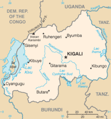
Map of Rwanda, showing location of
Nyabarongo River, which flows first north, then southeast past Kigali, then east along the southeastern border of Rwanda
358:. The main headwaters in the forested mountain country, originating at heights of 2,600 to 2,750 metres (8,530 to 9,020 ft) above sea level, are the
1165:
306:. The river begins its course at the confluence of the rivers Mbirurume and Mwogo in the South West of the country. These two rivers themselves begin in
749:
1127:
1082:
1057:
290:. With a total length of 351 km (218 mi), it is the longest river entirely in Rwanda. It is extended 421 km (262 mi) in
374:. The Rukarara flows south and then east, emptying into the Mwogo River. The Mwogo flows north, merging with the Mbirurume River south of
1028:
1299:
180:
932:
1158:
578:
117:
1009:
378:. From this confluence, the river assumes the name Nyabarongo. The source of the Rukarara is a contender for the overall
1258:
893:
Meierhenrich, Jens (October 2009). "The transformation oflieux de mémoire: The
Nyabarongo River in Rwanda, 1992-2009".
1273:
417:
The combined river flows east and then southeast through a broad, swampy valley. At the border with Burundi it drains
354:. The river's sources rise in the mountain chain that covers most of the western third of Rwanda, to the east of the
946:
1304:
554:
1294:
1151:
961:
546:
1174:
586:
470:, which mostly lies in Burundi, drains in a northeast direction into the river through a short swampy section.
570:
753:
562:
334:
482:
503:
421:. It then flows roughly east along the border between Rwanda and Burundi, then between Rwanda and
997:
875:
519:
311:
1225:
1119:
1123:
1078:
1053:
1047:
989:
981:
910:
867:
488:
476:
962:"Industrial discharges of metals in Kigali, Rwanda, and the impact on drinking water quality"
973:
902:
859:
406:
it swings to the southeast. On its left bank the Nyabugogo River delivers the outflow from
1205:
538:
511:
494:
375:
359:
441:. The river drains the east of the mountains and most of the central plateau of Rwanda.
1230:
1220:
1215:
1112:
594:
371:
367:
355:
307:
258:
394:
1288:
1263:
906:
879:
537:
The following species in the Nyabarongo River Wetlands are red-listed as endangered:
462:
434:
323:
49:
1001:
1253:
1248:
1194:
1092:
430:
426:
379:
319:
303:
299:
295:
262:
45:
863:
1268:
1240:
1210:
407:
363:
163:
1186:
467:
418:
338:
291:
914:
871:
195:
182:
132:
119:
527:
351:
960:
Gasana, J.; Twagilimana, L.; Hallenbeck, W.; Brenniman, G. (1 April 1997).
993:
977:
39:
17:
947:"Conservation of Nyabarongo Wetlands for Sustainable Livelihoods, Rwanda"
422:
86:
449:
403:
82:
720:
718:
654:
652:
650:
648:
635:
633:
350:
The Nyabarongo River originates in southwestern Rwanda to the east of
1178:
985:
620:
618:
454:
411:
283:
78:
697:
1143:
822:
393:
328:
279:
59:
833:
831:
438:
383:
366:
rivers. The longest of the streams that supply the Mwogo is the
287:
1147:
669:
667:
534:). The wetlands are under serious pressure from agriculture.
1046:
Hughes, Ralph H.; Hughes, Jane S.; Bernacsek, G. M. (1992).
1077:. Richmond, British Columbia: International Travel Maps.
966:
Bulletin of Environmental Contamination and Toxicology
798:
736:
724:
709:
658:
639:
624:
44:
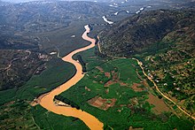
The confluence of the Nyawarungu (top right) and the
310:, and are considered by some to be the most distant
294:
including a 69 km (43 mi) upper course of
1239:
1185:
933:"BirdLife IBA Factsheet, RW004 Nyabarongo wetlands"
252:
242:
234:
229:
221:
211:
172:
162:
148:
109:
101:
92:
74:
69:
32:
1111:
837:
673:
810:
1159:
8:
774:
1166:
1152:
1144:
58:
425:, to the point where it is joined by the
685:
448:
614:
1118:. Twenty-First Century Books. p.
286:, part of the upper headwaters of the
29:
823:Conservation of Nyabarongo Wetlands..
429:. From there onward it is called the
7:
1029:"Journey to the source of the Nile"
799:Hughes, Hughes & Bernacsek 1992
737:Hughes, Hughes & Bernacsek 1992
725:Hughes, Hughes & Bernacsek 1992
710:Hughes, Hughes & Bernacsek 1992
659:Hughes, Hughes & Bernacsek 1992
640:Hughes, Hughes & Bernacsek 1992
625:Hughes, Hughes & Bernacsek 1992
333:An aerial of Nyabarongo River from
1049:Iucn Directory of African Wetlands
786:
25:
907:10.1111/j.1467-8322.2009.00687.x
750:"Exploring the Nyabarongo river"
38:
852:Society & Natural Resources
579:northern brown-throated weaver
386:, the most distant headwater.
174: • coordinates
111: • coordinates
1:
1027:Grainger, Lisa (2006-04-01).
864:10.1080/08941920.2016.1209605
93:Physical characteristics
1259:Koko River, Rutsiro District
217:1,323 m (4,341 ft)
213: • elevation
154:1,537 m (5,043 ft)
150: • elevation
1274:Koko River, Rusizi District
1321:
555:white-winged scrub-warbler
398:Canoeing on the Nyabarongo
1300:Protected areas of Rwanda
1110:Streissguth, Tom (2008).
1075:Rwanda/Burundi Travel Map
567:Chloropeta gracilirostris
225:351 km (218 mi)
158:
97:
57:
37:
1073:ITMB Publishing (2007).
587:white-collared oliveback
453:The Nyabarongo River in
437:, which drains into the
254: • right
510:), the near-threatened
433:, the main affluent of
244: • left
48:(top left) to form the
838:BirdLife IBA Factsheet
563:papyrus yellow warbler
547:Carruthers's cisticola
457:
399:
342:
322:eventually flows into
196:2.390024°S 30.780387°E
133:2.203503°S 29.567728°E
1052:. IUCN. p. 205.
978:10.1007/s001289900366
571:Sharpe's pied-babbler
551:Cisticola carruthersi
452:
397:
370:, which rises in the
335:Nyungwe National Park
332:
1010:"Nyabarongo: Rwanda"
674:ITMB Publishing 2007
559:Bradypterus carpalis
326:and forms the Nile.
298:before joining into
201:-2.390024; 30.780387
138:-2.203503; 29.567728
1033:The Daily Telegraph
591:Nesocharis ansorgei
543:Laniarius mufumbiri
524:Balearica regulorum
516:Laniarius mufumbiri
504:Malagasy pond heron
230:Basin features
192: /
129: /
1114:Rwanda in Pictures
895:Anthropology Today
811:Nyabarongo: Rwanda
698:Gasana et al. 1997
532:Tragelaphus spekii
520:grey crowned crane
518:), the vulnerable
458:
400:
343:
341:. Emmanuel Kwizera
312:source of the Nile
1305:Rivers of Burundi
1282:
1281:
1129:978-0-8225-8570-1
1098:. Ramsar Wetlands
1084:978-1-55341-380-6
1059:978-2-88032-949-5
599:Serinus koliensis
583:Ploceus castanops
575:Turdoides sharpei
489:Phoenix reclinata
477:Ficus verruculosa
268:
267:
16:(Redirected from
1312:
1295:Rivers of Rwanda
1201:Nyabarongo River
1168:
1161:
1154:
1145:
1139:
1137:
1136:
1117:
1106:
1104:
1103:
1097:
1088:
1069:
1067:
1066:
1042:
1040:
1039:
1023:
1021:
1020:
1014:Geographic Names
1005:
956:
954:
953:
942:
940:
939:
919:
918:
890:
884:
883:
847:
841:
835:
826:
820:
814:
808:
802:
796:
790:
784:
778:
775:Streissguth 2008
772:
766:
764:
762:
761:
752:. Archived from
746:
740:
734:
728:
722:
713:
707:
701:
695:
689:
683:
677:
671:
662:
656:
643:
637:
628:
622:
483:Myrica kandtiana
255:
245:
207:
206:
204:
203:
202:
197:
193:
190:
189:
188:
185:
151:
144:
143:
141:
140:
139:
134:
130:
127:
126:
125:
122:
112:
62:
42:
33:Nyabarongo River
30:
21:
1320:
1319:
1315:
1314:
1313:
1311:
1310:
1309:
1285:
1284:
1283:
1278:
1235:
1181:
1172:
1142:
1134:
1132:
1130:
1109:
1101:
1099:
1095:
1091:
1085:
1072:
1064:
1062:
1060:
1045:
1037:
1035:
1026:
1018:
1016:
1008:
959:
951:
949:
945:
937:
935:
931:
922:
892:
891:
887:
849:
848:
844:
836:
829:
821:
817:
809:
805:
797:
793:
785:
781:
773:
769:
759:
757:
748:
747:
743:
735:
731:
723:
716:
708:
704:
696:
692:
684:
680:
672:
665:
657:
646:
638:
631:
623:
616:
607:
539:papyrus gonolek
512:papyrus gonolek
495:Cyperus papyrus
447:
392:
348:
253:
248:Nyabugogo River
243:
214:
200:
198:
194:
191:
186:
183:
181:
179:
178:
175:
149:
137:
135:
131:
128:
123:
120:
118:
116:
115:
110:
65:
53:
28:
27:River in Rwanda
23:
22:
15:
12:
11:
5:
1318:
1316:
1308:
1307:
1302:
1297:
1287:
1286:
1280:
1279:
1277:
1276:
1271:
1266:
1261:
1256:
1251:
1245:
1243:
1237:
1236:
1234:
1233:
1228:
1223:
1218:
1213:
1208:
1203:
1198:
1191:
1189:
1183:
1182:
1173:
1171:
1170:
1163:
1156:
1148:
1141:
1140:
1128:
1107:
1089:
1083:
1070:
1058:
1043:
1024:
1006:
957:
943:
928:
921:
920:
885:
842:
827:
815:
803:
801:, p. 207.
791:
779:
767:
741:
739:, p. 125.
729:
727:, p. 206.
714:
712:, p. 205.
702:
700:, p. 523.
690:
678:
663:
661:, p. 201.
644:
642:, p. 199.
629:
613:
606:
603:
595:papyrus canary
446:
443:
391:
388:
372:Nyungwe Forest
356:Albertine Rift
347:
344:
308:Nyungwe Forest
266:
265:
259:Akanyaru River
256:
250:
249:
246:
240:
239:
236:
232:
231:
227:
226:
223:
219:
218:
215:
212:
209:
208:
176:
173:
170:
169:
166:
160:
159:
156:
155:
152:
146:
145:
113:
107:
106:
103:
99:
98:
95:
94:
90:
89:
76:
72:
71:
67:
66:
63:
55:
54:
43:
35:
34:
26:
24:
14:
13:
10:
9:
6:
4:
3:
2:
1317:
1306:
1303:
1301:
1298:
1296:
1293:
1292:
1290:
1275:
1272:
1270:
1267:
1265:
1264:Rubyiro River
1262:
1260:
1257:
1255:
1252:
1250:
1247:
1246:
1244:
1242:
1238:
1232:
1229:
1227:
1224:
1222:
1219:
1217:
1214:
1212:
1209:
1207:
1204:
1202:
1199:
1196:
1193:
1192:
1190:
1188:
1184:
1180:
1176:
1169:
1164:
1162:
1157:
1155:
1150:
1149:
1146:
1131:
1125:
1121:
1116:
1115:
1108:
1094:
1090:
1086:
1080:
1076:
1071:
1061:
1055:
1051:
1050:
1044:
1034:
1030:
1025:
1015:
1011:
1007:
1003:
999:
995:
991:
987:
983:
979:
975:
971:
967:
963:
958:
948:
944:
934:
930:
929:
927:
926:
916:
912:
908:
904:
900:
896:
889:
886:
881:
877:
873:
869:
865:
861:
857:
853:
846:
843:
839:
834:
832:
828:
824:
819:
816:
812:
807:
804:
800:
795:
792:
788:
783:
780:
777:, p. 13.
776:
771:
768:
756:on 2011-07-27
755:
751:
745:
742:
738:
733:
730:
726:
721:
719:
715:
711:
706:
703:
699:
694:
691:
687:
686:Grainger 2006
682:
679:
675:
670:
668:
664:
660:
655:
653:
651:
649:
645:
641:
636:
634:
630:
627:, p. 97.
626:
621:
619:
615:
612:
611:
604:
602:
600:
596:
592:
588:
584:
580:
576:
572:
568:
564:
560:
556:
552:
548:
544:
540:
535:
533:
529:
525:
521:
517:
513:
509:
505:
499:
497:
496:
491:
490:
485:
484:
479:
478:
471:
469:
464:
463:Lake Mugesera
456:
451:
444:
442:
440:
436:
435:Lake Victoria
432:
428:
424:
420:
415:
413:
409:
405:
396:
389:
387:
385:
381:
377:
373:
369:
365:
361:
357:
353:
345:
340:
336:
331:
327:
325:
324:Lake Victoria
321:
315:
313:
309:
305:
301:
297:
293:
289:
285:
281:
278:) is a major
277:
273:
264:
260:
257:
251:
247:
241:
237:
233:
228:
224:
220:
216:
210:
205:
177:
171:
167:
165:
161:
157:
153:
147:
142:
114:
108:
104:
100:
96:
91:
88:
84:
80:
77:
73:
68:
61:
56:
52:(foreground).
51:
50:Akagera River
47:
41:
36:
31:
19:
1254:Sebeya River
1249:Ruzizi River
1200:
1133:. Retrieved
1113:
1100:. Retrieved
1074:
1063:. Retrieved
1048:
1036:. Retrieved
1032:
1017:. Retrieved
1013:
972:(4): 523–6.
969:
965:
950:. Retrieved
936:. Retrieved
924:
923:
901:(5): 13–19.
898:
894:
888:
855:
851:
845:
818:
806:
794:
782:
770:
758:. Retrieved
754:the original
744:
732:
705:
693:
681:
609:
608:
598:
590:
582:
574:
566:
558:
550:
542:
536:
531:
523:
515:
508:Ardeola idae
507:
500:
493:
487:
481:
475:
472:
459:
431:Kagera River
427:Ruvuvu River
416:
401:
349:
320:Kagera River
316:
304:Kagera River
302:to form the
300:Ruvuvu River
296:Kagera River
275:
271:
269:
263:Ruvuvu River
1269:Ruhwa River
1241:Congo Basin
858:(1): 3–15.
526:), and the
408:Lake Muhazi
235:Tributaries
199: /
136: /
1289:Categories
1187:Nile Basin
1135:2013-03-25
1102:2013-03-26
1065:2013-03-25
1038:2011-12-02
1019:2010-09-09
952:2010-09-09
938:2010-09-09
760:2010-09-09
605:References
468:Lake Rweru
419:Lake Rweru
339:River Nile
292:Lake Rweru
276:Nyawarungu
272:Nyabarongo
187:30°46′49″E
124:29°34′04″E
18:Nyabarongo
1206:Mbirurume
1197:/ Akagera
915:0268-540X
880:157257014
872:0894-1920
610:Citations
528:sitatunga
360:Mbirurume
352:Lake Kivu
184:2°23′24″S
121:2°12′13″S
1231:Akanyaru
1221:Mukungwa
1216:Rukarara
1093:"RWANDA"
1002:30730076
445:Wetlands
423:Tanzania
368:Rukarara
87:Tanzania
70:Location
994:9060368
925:Sources
593:), and
404:Muramba
382:of the
376:Bwakira
346:Origins
83:Burundi
75:Country
1195:Kagera
1179:Rwanda
1175:Rivers
1126:
1081:
1056:
1000:
992:
986:535287
984:
913:
878:
870:
787:RWANDA
455:Rwanda
412:Kigali
390:Course
380:source
284:Rwanda
238:
222:Length
168:
105:
102:Source
79:Rwanda
46:Ruvubu
1211:Mwogo
1096:(PDF)
998:S2CID
876:S2CID
364:Mwogo
280:river
164:Mouth
1226:Base
1124:ISBN
1079:ISBN
1054:ISBN
990:PMID
982:OSTI
911:ISSN
868:ISSN
492:and
439:Nile
384:Nile
362:and
288:Nile
274:(or
270:The
1177:of
974:doi
903:doi
860:doi
601:).
585:),
577:),
569:),
561:),
553:),
545:),
337:to
282:in
1291::
1122:.
1120:13
1031:.
1012:.
996:.
988:.
980:.
970:58
968:.
964:.
909:.
899:25
897:.
874:.
866:.
856:30
854:.
830:^
717:^
666:^
647:^
632:^
617:^
486:,
480:,
414:.
261:,
85:,
81:,
1167:e
1160:t
1153:v
1138:.
1105:.
1087:.
1068:.
1041:.
1022:.
1004:.
976::
955:.
941:.
917:.
905::
882:.
862::
840:.
825:.
813:.
789:.
765:.
763:.
688:.
676:.
597:(
589:(
581:(
573:(
565:(
557:(
549:(
541:(
530:(
522:(
514:(
506:(
20:)
Text is available under the Creative Commons Attribution-ShareAlike License. Additional terms may apply.