514:
450:
530:
498:
139:
29:
179:
146:
482:
172:
410:
434:
466:
770:
790:
762:
745:
397:
danger. During winter months, weather is usually cloudy, but due to high pressure systems over the
Pacific Ocean that intensify during summer months, there is often little or no cloud cover during the summer. The months of July through September offer the most favorable weather for viewing or
389:), causing them to drop their moisture in the form of rain or snow onto the Cascades. As a result, the west side of the Cascades experiences high precipitation, especially during the winter months in the form of snowfall. Because of
513:
94:
847:
837:
449:
701:
138:
529:
497:
842:
622:
171:
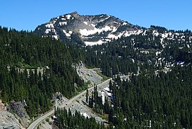
852:
613:
481:
694:
662:
618:
419:
270:
687:
311:
244:
87:
433:
362:
307:
240:
319:
315:
230:
226:
799:
28:
608:
465:
323:
295:
216:
832:
64:
54:
77:
674:
648:
Beckey, Fred W. Cascade Alpine Guide, Climbing and High Routes. Seattle, WA: Mountaineers Books, 2008.
353:
in 1927. The Naches Peak Loop Trail is a popular 3.5 mile trail encircling the peak. Precipitation
346:
343:
382:
374:
358:
414:
754:
390:
386:
265:
357:
from the west side of Naches Peak drains into
Chinook Creek, which is a tributary of the
354:
251:
826:
721:
378:
350:
327:
258:
804:
776:
726:
335:
331:
285:
69:
679:
738:
731:
385:. As fronts approach, they are forced upward by the peaks of the Cascade Range (
563:
809:
783:
292:
109:
96:
394:
306:
is a 6,452-foot (1,967 m) mountain summit located on the shared border of
584:
44:
683:
381:
originating in the
Pacific Ocean travel northeast toward the
668:
361:, whereas the east side drains into tributaries of the
644:
642:
640:
638:
393:, snow tends to be wet and heavy, resulting in high
338:, 1.45 mi (2.33 km) to the east. The name
326:state. Naches Peak is situated on the crest of the
284:
279:
264:
250:
236:
222:
212:
204:
125:
86:
76:
63:
53:
43:
38:
21:
695:
579:
577:
16:Mountain in Washington (state), United States
8:
377:climate zone of western North America. Most
702:
688:
680:
18:
623:United States Department of the Interior
550:
429:
848:Mountains of Yakima County, Washington
838:Mountains of Pierce County, Washington
314:. It is also on the shared border of
158:Location of Naches Peak in Washington
7:
717:
558:
556:
554:
614:Geographic Names Information System
489:Lupine wildflowers along loop trail
178:
145:
673:National Forest Service web site:
505:Indian paintbrush along loop trail
14:
334:. Its nearest higher neighbor is
33:Naches Peak seen from Highway 410
788:
768:
760:
743:
667:National Park Service web site:
528:
512:
496:
480:
464:
448:
432:
408:
177:
170:
144:
137:
27:
843:Mountains of Washington (state)
619:United States Geological Survey
420:Geography of Washington (state)
191:Naches Peak (the United States)
710:Places adjacent to Naches Peak
373:Naches Peak is located in the
161:Show map of Washington (state)
1:
853:North American 1000 m summits
789:
744:
330:and immediately southeast of
312:William O. Douglas Wilderness
245:William O. Douglas Wilderness
194:Show map of the United States
769:
761:
675:William O Douglas Wilderness
49:6,452 ft (1,967 m)
669:Mount Rainier National Park
308:Mount Rainier National Park
241:Mount Rainier National Park
82:1.45 mi (2.33 km)
869:
715:
585:"Naches Peak - 6,452' WA"
564:"Naches Peak, Washington"
130:
26:
110:46.867741°N 121.507694°W
59:692 ft (211 m)
441:Naches Peak from north
115:46.867741; -121.507694
521:Fern along loop trail
415:Mountains portal
398:climbing this peak.
342:was proposed by the
347:Chamber of Commerce
237:Protected area
106: /
537:Sitka Mountain-ash
391:maritime influence
39:Highest point
820:
819:
815:
814:
383:Cascade Mountains
375:marine west coast
359:Ohanapecosh River
301:
300:
860:
792:
791:
772:
771:
764:
763:
747:
746:
718:
704:
697:
690:
681:
663:weather forecast
649:
646:
633:
632:
630:
629:
605:
599:
598:
596:
595:
581:
572:
571:
560:
532:
516:
500:
484:
468:
452:
436:
413:
412:
411:
349:and approved by
288:
254:
195:
181:
180:
174:
162:
148:
147:
141:
121:
120:
118:
117:
116:
111:
107:
104:
103:
102:
99:
31:
19:
868:
867:
863:
862:
861:
859:
858:
857:
823:
822:
821:
816:
773:
755:Governors Ridge
711:
708:
658:
653:
652:
647:
636:
627:
625:
607:
606:
602:
593:
591:
589:listsofjohn.com
583:
582:
575:
562:
561:
552:
547:
540:
539:
533:
524:
523:
517:
508:
507:
501:
492:
491:
485:
476:
475:
469:
460:
459:
453:
444:
443:
437:
428:
409:
407:
404:
387:orographic lift
371:
286:
252:
243:
200:
199:
198:
197:
196:
193:
192:
189:
188:
187:
186:
182:
165:
164:
163:
160:
159:
156:
155:
154:
153:
149:
114:
112:
108:
105:
100:
97:
95:
93:
92:
34:
17:
12:
11:
5:
866:
864:
856:
855:
850:
845:
840:
835:
825:
824:
818:
817:
813:
812:
807:
802:
796:
795:
793:
786:
780:
779:
774:
759:
757:
751:
750:
748:
741:
735:
734:
729:
724:
716:
713:
712:
709:
707:
706:
699:
692:
684:
678:
677:
671:
665:
657:
656:External links
654:
651:
650:
634:
600:
573:
568:Peakbagger.com
549:
548:
546:
543:
542:
541:
535:
534:
527:
525:
519:
518:
511:
509:
503:
502:
495:
493:
487:
486:
479:
477:
471:
470:
463:
461:
455:
454:
447:
445:
439:
438:
431:
427:
424:
423:
422:
417:
403:
400:
379:weather fronts
370:
367:
363:American River
299:
298:
290:
282:
281:
277:
276:
268:
262:
261:
256:
248:
247:
238:
234:
233:
224:
220:
219:
214:
210:
209:
206:
202:
201:
190:
184:
183:
176:
175:
169:
168:
167:
166:
157:
151:
150:
143:
142:
136:
135:
134:
133:
132:
131:
128:
127:
123:
122:
90:
84:
83:
80:
74:
73:
67:
61:
60:
57:
51:
50:
47:
41:
40:
36:
35:
32:
24:
23:
15:
13:
10:
9:
6:
4:
3:
2:
865:
854:
851:
849:
846:
844:
841:
839:
836:
834:
833:Cascade Range
831:
830:
828:
811:
808:
806:
803:
801:
798:
797:
794:
787:
785:
782:
781:
778:
775:
767:
758:
756:
753:
752:
749:
742:
740:
737:
736:
733:
730:
728:
725:
723:
722:Deadwood Peak
720:
719:
714:
705:
700:
698:
693:
691:
686:
685:
682:
676:
672:
670:
666:
664:
660:
659:
655:
645:
643:
641:
639:
635:
624:
620:
616:
615:
610:
609:"Naches Peak"
604:
601:
590:
586:
580:
578:
574:
569:
565:
559:
557:
555:
551:
544:
538:
531:
526:
522:
515:
510:
506:
499:
494:
490:
483:
478:
474:
467:
462:
458:
451:
446:
442:
435:
430:
425:
421:
418:
416:
406:
405:
401:
399:
396:
392:
388:
384:
380:
376:
368:
366:
364:
360:
356:
352:
351:Asahel Curtis
348:
345:
341:
337:
333:
329:
328:Cascade Range
325:
321:
320:Yakima County
317:
316:Pierce County
313:
309:
305:
297:
294:
291:
289:
287:Easiest route
283:
278:
275:
272:
269:
267:
263:
260:
257:
255:
249:
246:
242:
239:
235:
232:
228:
225:
221:
218:
215:
211:
208:United States
207:
203:
173:
140:
129:
124:
119:
91:
89:
85:
81:
79:
75:
71:
68:
66:
62:
58:
56:
52:
48:
46:
42:
37:
30:
25:
20:
805:Seymour Peak
777:Tahtlum Peak
765:
727:Chinook Peak
661:Naches Peak
626:. Retrieved
612:
603:
592:. Retrieved
588:
567:
536:
520:
504:
488:
472:
456:
440:
372:
339:
336:Tahtlum Peak
332:Chinook Pass
303:
302:
296:class 4
274:Chinook Pass
273:
253:Parent range
70:Tahtlum Peak
800:Double Peak
766:Naches Peak
739:Yakima Peak
732:Fifes Peaks
473:East aspect
457:West aspect
340:Naches Peak
304:Naches Peak
185:Naches Peak
152:Naches Peak
113: /
101:121°30′28″W
88:Coordinates
65:Parent peak
22:Naches Peak
827:Categories
810:Dewey Peak
784:Buell Peak
628:2018-08-09
594:2020-08-24
545:References
324:Washington
293:Scrambling
217:Washington
98:46°52′04″N
72:(6,567 ft)
55:Prominence
395:avalanche
126:Geography
78:Isolation
45:Elevation
402:See also
280:Climbing
266:Topo map
259:Cascades
426:Gallery
369:Climate
205:Country
355:runoff
344:Yakima
231:Yakima
227:Pierce
223:County
213:State
318:and
310:and
271:USGS
322:in
829::
637:^
621:,
617:.
611:.
587:.
576:^
566:.
553:^
365:.
229:/
703:e
696:t
689:v
631:.
597:.
570:.
Text is available under the Creative Commons Attribution-ShareAlike License. Additional terms may apply.