164:
176:
152:
188:
77:
in the early 18th century. In the late 19th century, records indicate that this was a "toth falu" (Slovak village) with a majority Slovak population, but with a sizeable
Hungarian minority. After Hungary was partitioned in 1920, Natafalva found itself in the newly created Czechoslovakia. Many Hungarian residents of the town left, immigrating to North America or back to what was left of Hungary. The name was changed from Natafalva to Nacina Ves and during World War II, remaining Hungarians who did not swear that they were Slovaks were expelled.
729:
674:
20:
76:
was first mentioned in 1219. The
Hungarian State Archives record that the village was granted by King Bela IV to his son Nata and the name became Natafalva. (Village of Nata) The Natafalusi family were the nobles who controlled the town for hundreds of years, many of them moving after the Kuruc Wars
163:
792:
175:
151:
773:
248:
797:
209:
187:
766:
241:
447:
407:
342:
687:
642:
487:
542:
492:
472:
221:
759:
367:
302:
234:
402:
132:
Nacina Ves also has its own small railway station, located west of the village, next to the local railway line between
382:
417:
652:
597:
657:
467:
602:
284:
297:
527:
739:
512:
507:
607:
126:
736:
547:
532:
258:
204:
53:
23:
457:
587:
37:
632:
627:
497:
743:
57:
113:
The village has three bus stops with bus shelters. Regular bus routes available include to
327:
226:
372:
332:
277:
222:
https://web.archive.org/web/20080111223415/http://www.statistics.sk/mosmis/eng/run.html
118:
786:
517:
347:
27:
322:
98:
49:
728:
582:
577:
412:
637:
442:
432:
427:
357:
19:
552:
522:
502:
452:
392:
377:
337:
270:
137:
133:
122:
114:
102:
702:
689:
567:
662:
592:
482:
397:
362:
673:
612:
572:
562:
557:
537:
462:
437:
422:
317:
307:
90:
622:
352:
312:
86:
73:
69:
45:
140:(part of the ŽSR regional line no. 191 between Michaľany and Lupków).
647:
617:
292:
387:
18:
94:
230:
747:
205:
List of municipalities and towns in
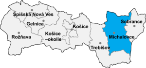
Michalovce District
793:Villages and municipalities in Michalovce District
767:
242:
8:
210:List of municipalities and towns in Slovakia
774:
760:
249:
235:
227:
181:Municipal office building in Nacina Ves
157:Main road and main street in Nacina Ves
147:
7:
725:
723:
16:Village and municipality in Slovakia
798:Michalovce District geography stubs
746:. You can help Knowledge (XXG) by
14:
727:
672:
193:Local shop and pub in Nacina Ves
186:
174:
162:
150:
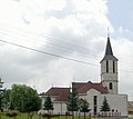
169:All Saints Church in Nacina Ves
1:
93:of 125 metres and covers an
383:Jastrabie pri Michalovciach
814:
722:
669:
265:
97:of 15.803 km. The
105:of about 1750 people.
41:
30:
513:Poruba pod Vihorlatom
508:Petrovce nad Laborcom
60:of eastern Slovakia.
22:
737:Michalovce District
699: /
533:Rakovec nad Ondavou
403:Kapušianske Kľačany
298:Bánovce nad Ondavou
259:Michalovce District
54:Michalovce District
24:Michalovce District
658:Zemplínske Kopčany
588:Trnava pri Laborci
418:Krišovská Liesková
257:Municipalities of
70:historical records
31:
755:
754:
703:48.817°N 21.850°E
682:
681:
653:Zemplínska Široká
498:Pavlovce nad Uhom
468:Maťovské Vojkovce
127:Vranov nad Topľou
805:
776:
769:
762:
731:
724:
714:
713:
711:
710:
709:
704:
700:
697:
696:
695:
692:
677:
676:
598:Tušická Nová Ves
251:
244:
237:
228:
190:
178:
166:
154:
813:
812:
808:
807:
806:
804:
803:
802:
783:
782:
781:
780:
720:
717:
707:
705:
701:
698:
693:
690:
688:
686:
685:
683:
678:
671:
667:
633:Vysoká nad Uhom
261:
255:
218:
201:
194:
191:
182:
179:
170:
167:
158:
155:
146:
111:
83:
66:
17:
12:
11:
5:
811:
809:
801:
800:
795:
785:
784:
779:
778:
771:
764:
756:
753:
752:
732:
708:48.817; 21.850
680:
679:
670:
668:
666:
665:
660:
655:
650:
645:
640:
635:
630:
625:
620:
615:
610:
608:Veľké Slemence
605:
603:Veľké Raškovce
600:
595:
590:
585:
580:
575:
570:
565:
560:
555:
550:
545:
540:
535:
530:
525:
520:
515:
510:
505:
500:
495:
490:
485:
480:
475:
470:
465:
460:
455:
450:
445:
440:
435:
430:
425:
420:
415:
410:
405:
400:
395:
390:
385:
380:
375:
370:
365:
360:
355:
350:
345:
340:
335:
330:
325:
320:
315:
310:
305:
300:
295:
289:
288:
285:Veľké Kapušany
281:
274:
266:
263:
262:
256:
254:
253:
246:
239:
231:
225:
224:
217:
216:External links
214:
213:
212:
207:
200:
197:
196:
195:
192:
185:
183:
180:
173:
171:
168:
161:
159:
156:
149:
145:
142:
110:
107:
82:
79:
65:
62:
15:
13:
10:
9:
6:
4:
3:
2:
810:
799:
796:
794:
791:
790:
788:
777:
772:
770:
765:
763:
758:
757:
751:
749:
745:
742:article is a
741:
738:
733:
730:
726:
721:
718:
715:
712:
675:
664:
661:
659:
656:
654:
651:
649:
646:
644:
641:
639:
636:
634:
631:
629:
626:
624:
621:
619:
616:
614:
611:
609:
606:
604:
601:
599:
596:
594:
591:
589:
586:
584:
581:
579:
576:
574:
571:
569:
566:
564:
561:
559:
556:
554:
551:
549:
546:
544:
541:
539:
536:
534:
531:
529:
528:Pusté Čemerné
526:
524:
521:
519:
516:
514:
511:
509:
506:
504:
501:
499:
496:
494:
491:
489:
486:
484:
481:
479:
476:
474:
471:
469:
466:
464:
461:
459:
458:Malé Raškovce
456:
454:
451:
449:
446:
444:
441:
439:
436:
434:
431:
429:
426:
424:
421:
419:
416:
414:
411:
409:
406:
404:
401:
399:
396:
394:
391:
389:
386:
384:
381:
379:
376:
374:
371:
369:
366:
364:
361:
359:
356:
354:
351:
349:
346:
344:
341:
339:
336:
334:
331:
329:
326:
324:
321:
319:
316:
314:
311:
309:
306:
304:
301:
299:
296:
294:
291:
290:
287:
286:
282:
280:
279:
275:
273:
272:
268:
267:
264:
260:
252:
247:
245:
240:
238:
233:
232:
229:
223:
220:
219:
215:
211:
208:
206:
203:
202:
198:
189:
184:
177:
172:
165:
160:
153:
148:
143:
141:
139:
135:
130:
128:
124:
120:
116:
108:
106:
104:
100:
96:
92:
88:
80:
78:
75:
71:
63:
61:
59:
58:Košice Region
55:
51:
47:
43:
39:
35:
29:
28:Kosice Region
25:
21:
748:expanding it
734:
719:
716:
684:
477:
283:
276:
269:
131:
112:
99:municipality
84:
67:
50:municipality
33:
32:
706: /
333:Čierne Pole
89:lies at an
787:Categories
553:Sliepkovce
518:Pozdišovce
503:Petrikovce
478:Nacina Ves
348:Falkušovce
271:Michalovce
134:Michalovce
115:Michalovce
103:population
34:Nacina Ves
740:geography
583:Trhovište
578:Šamudovce
568:Stretavka
548:Slavkovce
413:Krásnovce
328:Čičarovce
109:Transport
81:Geography
42:Nátafalva
38:Hungarian
638:Zalužice
563:Stretava
473:Moravany
463:Markovce
433:Laškovce
428:Lastomír
408:Klokočov
373:Iňačovce
343:Dúbravka
318:Budkovce
308:Bracovce
278:Strážske
199:See also
119:Strážske
91:altitude
694:21°51′E
691:48°49′N
643:Závadka
628:Vrbnica
523:Ptrukša
453:Malčice
393:Kačanov
378:Ižkovce
368:Horovce
353:Hatalov
338:Drahňov
323:Čečehov
313:Budince
144:Gallery
138:Humenné
123:Humenné
87:village
74:village
64:History
56:in the
46:village
44:) is a
26:in the
663:Žbince
648:Zbudza
618:Vojany
593:Tušice
488:Oreské
483:Oborín
398:Kaluža
363:Hnojné
293:Bajany
101:has a
735:This
613:Vinné
573:Suché
558:Staré
543:Senné
538:Ruská
493:Palín
448:Lúčky
443:Ložín
438:Lesné
423:Kusín
388:Jovsa
358:Hažín
744:stub
623:Voľa
303:Beša
136:and
125:and
95:area
85:The
72:the
48:and
68:In
52:in
789::
129:.
121:,
117:,
40::
775:e
768:t
761:v
750:.
250:e
243:t
236:v
36:(
Text is available under the Creative Commons Attribution-ShareAlike License. Additional terms may apply.