42:
29:
400:
49:
570:
565:
342:
158:
575:
361:
The
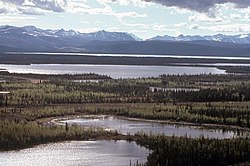
Nabesna River, swift-flowing in its upper reaches, passes through a deep valley that opens into broad plain. Gradually slowing, the river enters the
580:
369:
115:
111:
538:
491:
41:
368:
The river, suited to running by rafts, hard-shelled kayaks, or decked canoes, is rated Class I (easy) to Class II (medium) on the
258:
362:
244:
240:
154:
172:
585:
560:
350:
413:
444:
380:
channels. Glacier melt may cause flow rates to rise significantly between morning and afternoon on warm days.
318:
76:
346:
146:
507:
534:
487:
372:. The current is swift on the stream's upper 40 miles (64 km) and slow from there to the
28:
334:
134:
393:
554:
389:
377:
470:
338:
322:
223:
150:
399:
373:
236:
218:
326:
273:
260:
187:
174:
531:
The Alaska River Guide: Canoeing, Kayaking, and
Rafting in the Last Frontier
533:(3rd ed.). Birmingham, Alabama: Menasha Ridge Press. pp. 247–48.
365:, a region of marshes, hills, lakes, and forests of spruce and birch.
486:(7th ed.). Yarmouth, Maine: DeLorme. 2010. pp. 98–99, 109.
388:
The
Nabesna is a popular fishing site in Alaska. Species such as the
330:
101:
398:
56:
Location of the mouth of the
Nabesna River in Alaska
299:
289:
250:
229:
217:
203:
164:
140:
130:
121:
107:
97:
89:
84:
64:
21:
451:. United States Geological Survey. January 1, 2000
68:
571:Rivers of Southeast Fairbanks Census Area, Alaska
376:. Dangers include cold, swift, silty water, and
321:) is a 73-mile (117 km) tributary of the
343:Wrangell–St. Elias National Park and Preserve
159:Wrangell–St. Elias National Park and Preserve
8:
566:Rivers of Copper River Census Area, Alaska
469:Derived by entering source coordinates in
425:
370:International Scale of River Difficulty
353:. The combined rivers form the Tanana.
439:
437:
435:
433:
431:
429:
18:
576:Rivers of Unorganized Borough, Alaska
48:
7:
449:Geographic Names Information System
235:41 miles (66 km) southeast of
14:
341:, it flows north-northeast from
47:
40:
27:
363:Tetlin National Wildlife Refuge
245:Tetlin National Wildlife Refuge
241:Southeast Fairbanks Census Area
581:Tributaries of the Yukon River
396:, Red Salmon and Coho Salmon.
252: • coordinates
166: • coordinates
16:River in Alaska, United States
1:
122:Physical characteristics
484:Alaska Atlas & Gazetteer
291: • elevation
205: • elevation
231: • location
142: • location
602:
295:1,690 ft (520 m)
209:3,061 ft (933 m)
155:Valdez–Cordova Census Area
213:
126:
35:
26:
529:Jettmar, Karen (2008) .
414:List of rivers of Alaska
303:73 mi (117 km)
69:
404:
274:63.04917°N 141.86583°W
188:62.16944°N 142.85000°W
402:
279:63.04917; -141.86583
193:62.16944; -142.85000
270: /
184: /
116:Southeast Fairbanks
586:Tanana Athabaskans
405:
147:Wrangell Mountains
540:978-0-89732-957-6
493:978-0-89933-289-5
351:Northway Junction
307:
306:
593:
561:Rivers of Alaska
545:
544:
526:
520:
519:
517:
515:
504:
498:
497:
480:
474:
467:
461:
460:
458:
456:
441:
285:
284:
282:
281:
280:
275:
271:
268:
267:
266:
263:
206:
199:
198:
196:
195:
194:
189:
185:
182:
181:
180:
177:
167:
143:
80:
72:
51:
50:
44:
31:
19:
601:
600:
596:
595:
594:
592:
591:
590:
551:
550:
549:
548:
541:
528:
527:
523:
513:
511:
508:"Nabesna River"
506:
505:
501:
494:
482:
481:
477:
468:
464:
454:
452:
445:"Nabesna River"
443:
442:
427:
422:
410:
386:
359:
335:Nabesna Glacier
333:. Beginning at
292:
278:
276:
272:
269:
264:
261:
259:
257:
256:
253:
232:
204:
192:
190:
186:
183:
178:
175:
173:
171:
170:
165:
141:
135:Nabesna Glacier
74:
60:
59:
58:
57:
54:
53:
52:
17:
12:
11:
5:
599:
597:
589:
588:
583:
578:
573:
568:
563:
553:
552:
547:
546:
539:
521:
499:
492:
475:
462:
424:
423:
421:
418:
417:
416:
409:
406:
385:
382:
358:
355:
305:
304:
301:
297:
296:
293:
290:
287:
286:
254:
251:
248:
247:
233:
230:
227:
226:
221:
215:
214:
211:
210:
207:
201:
200:
168:
162:
161:
144:
138:
137:
132:
128:
127:
124:
123:
119:
118:
112:Valdez–Cordova
109:
105:
104:
99:
95:
94:
91:
87:
86:
82:
81:
66:
62:
61:
55:
46:
45:
39:
38:
37:
36:
33:
32:
24:
23:
15:
13:
10:
9:
6:
4:
3:
2:
598:
587:
584:
582:
579:
577:
574:
572:
569:
567:
564:
562:
559:
558:
556:
542:
536:
532:
525:
522:
509:
503:
500:
495:
489:
485:
479:
476:
472:
466:
463:
450:
446:
440:
438:
436:
434:
432:
430:
426:
419:
415:
412:
411:
407:
403:Rainbow Trout
401:
397:
395:
391:
390:Rainbow Trout
383:
381:
379:
375:
371:
366:
364:
356:
354:
352:
348:
347:Chisana River
344:
340:
336:
332:
328:
324:
320:
316:
315:Naambia Niign
312:
311:Nabesna River
302:
298:
294:
288:
283:
255:
249:
246:
242:
238:
234:
228:
225:
222:
220:
216:
212:
208:
202:
197:
169:
163:
160:
156:
152:
148:
145:
139:
136:
133:
129:
125:
120:
117:
113:
110:
106:
103:
100:
96:
93:United States
92:
88:
83:
78:
71:
70:Naambia Niign
67:
63:
43:
34:
30:
25:
22:Nabesna River
20:
530:
524:
512:. Retrieved
510:. Trails.com
502:
483:
478:
471:Google Earth
465:
453:. Retrieved
448:
387:
367:
360:
345:to join the
339:Alaska Range
323:Tanana River
319:Upper Tanana
314:
310:
308:
224:Tanana River
151:Alaska Range
77:Upper Tanana
514:January 31,
455:October 28,
394:King Salmon
277: /
265:141°51′57″W
191: /
179:142°51′00″W
108:Census Area
65:Native name
555:Categories
420:References
327:U.S. state
262:63°02′57″N
176:62°10′10″N
408:See also
85:Location
384:Fishing
378:braided
357:Boating
337:in the
325:in the
90:Country
537:
490:
331:Alaska
300:Length
131:Source
102:Alaska
73:
374:mouth
349:near
219:Mouth
98:State
535:ISBN
516:2013
488:ISBN
457:2013
309:The
329:of
317:in
237:Tok
557::
447:.
428:^
392:,
243:,
239:,
157:,
153:,
149:,
114:,
543:.
518:.
496:.
473:.
459:.
313:(
79:)
75:(
Text is available under the Creative Commons Attribution-ShareAlike License. Additional terms may apply.