289:
537:
484:
36:
40:
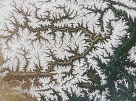
Satellite view of Namcha Barwa Himal range surrounded by Great Bend of the
Yarlung Tsangpo River (Brahmaputra River). Namcha Barwa Himal range runs diagonally from bottom left to top right corner, and Naamcha Barwa peak is in the top right at the end of the range. Gyala Peri peak in the Nyenchen
284:
range, stands about 22 km NNW of Namche Barwa, across the
Yarlung Tsangpo but often included in the Namche Barwa Himal range because of proximity.
578:
521:
607:
288:
602:
597:
617:
612:
252:
213:
177:
137:
571:
514:
105:
306:
121:
345:
564:
507:
366:
333:
536:
281:
100:
in southeastern Tibet and northeastern India. This section spans 180 km from the headwaters of the
458:
328:
400:
109:
323:
117:
483:
113:
41:
Tanglha Shan range is just 20 km north of
Naamcha Barwa peak across the Yarlung Tsangpo River.
35:
76:
548:
491:
591:
131:
318:
101:
433:
246:
267:
254:
228:
215:
192:
179:
152:
139:
166:
97:
116:
in India), where the
Himalaya are said to end, although high ranges (
544:
287:
292:
The Namcha Barwa Himal range photographed from Apollo 9 (1969).
552:
495:
414:(59). Boulder, Colorado: American Alpine Club: 334–36
72:
67:
59:
51:
46:
23:
104:on the international border NE into Tibet to the
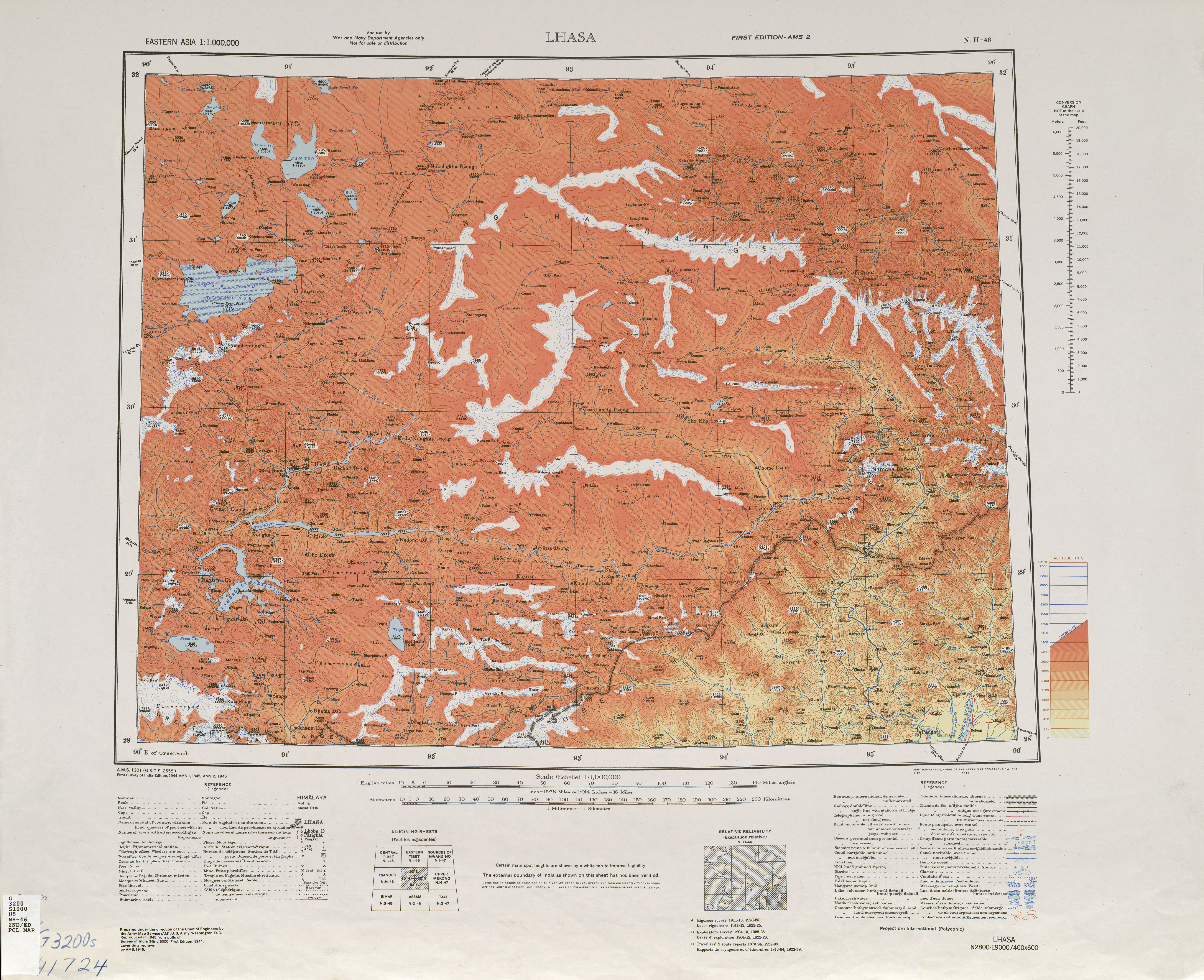
463:(Map). 1:1,000,000. U.S. Army Map Service. 1945
124:) actually continue another 300 km east.
572:
515:
8:
579:
565:
522:
508:
20:
357:
127:Major peaks of this section include:
7:
533:
531:
480:
478:
96:, is the easternmost section of the
380:(59). American Alpine Club: 116–120
490:This Indian location article is a
14:
535:
482:
367:"Classification of the Himalaya"
34:
608:Landforms of Arunachal Pradesh
1:
551:. You can help Knowledge by
494:. You can help Knowledge by
79:, Nyingchi Prefecture, China
401:"Namcha Barwa and Nai Peng"
334:GPX (secondary coordinates)
634:
530:
477:
329:GPX (primary coordinates)
304:Map all coordinates using
165:, considered easternmost
94:Namjagbarwa Group Complex
55:180 km (110 mi)
33:
28:
603:Mountain ranges of Tibet
598:Mountain ranges of India
365:H. Adams Carter (1985).
346:Geology of the Himalayas
312:Download coordinates as:
408:American Alpine Journal
374:American Alpine Journal
210:Sentang Bu, 6,812 m at
63:60 km (37 mi)
547:location article is a
434:"Nyainqêntanglha Shan"
293:
618:Tibet geography stubs
613:India geography stubs
324:GPX (all coordinates)
291:
282:Nyenchen Tanglha Shan
268:29.81417°N 94.96833°E
229:29.83000°N 95.01000°E
193:29.62000°N 95.05000°E
174:Nai Peng, 7,043 m at
153:29.62917°N 95.05583°E
205:, first climbed 1984
122:China–Myanmar border
90:Namjagbarwa syntaxis
399:Zhou Zheng (1985).
264: /
225: /
189: /
149: /
294:
273:29.81417; 94.96833
234:29.83000; 95.01000
198:29.62000; 95.05000
158:29.62917; 95.05583
118:Hengduan Mountains
86:Namcha Barwa Himal
24:Namcha Barwa Himal
16:Mountains in India
560:
559:
503:
502:
83:
82:
625:
581:
574:
567:
539:
532:
524:
517:
510:
486:
479:
472:
470:
468:
446:
445:
443:
441:
436:. peakbagger.com
430:
424:
423:
421:
419:
405:
396:
390:
389:
387:
385:
371:
362:
279:
278:
276:
275:
274:
269:
265:
262:
261:
260:
257:
240:
239:
237:
236:
235:
230:
226:
223:
222:
221:
218:
204:
203:
201:
200:
199:
194:
190:
187:
186:
185:
182:
164:
163:
161:
160:
159:
154:
150:
147:
146:
145:
142:
88:, also known as
38:
21:
633:
632:
628:
627:
626:
624:
623:
622:
588:
587:
586:
585:
529:
528:
475:
466:
464:
457:
455:
450:
449:
439:
437:
432:
431:
427:
417:
415:
403:
398:
397:
393:
383:
381:
369:
364:
363:
359:
354:
342:
341:
340:
339:
338:
299:
272:
270:
266:
263:
258:
255:
253:
251:
250:
233:
231:
227:
224:
219:
216:
214:
212:
211:
197:
195:
191:
188:
183:
180:
178:
176:
175:
157:
155:
151:
148:
143:
140:
138:
136:
135:
110:Yarlung Tsangpo
42:
17:
12:
11:
5:
631:
629:
621:
620:
615:
610:
605:
600:
590:
589:
584:
583:
576:
569:
561:
558:
557:
540:
527:
526:
519:
512:
504:
501:
500:
487:
454:
453:External links
451:
448:
447:
425:
391:
356:
355:
353:
350:
349:
348:
337:
336:
331:
326:
321:
315:
309:
302:
301:
300:
298:
295:
286:
285:
243:
242:
207:
206:
171:
170:
81:
80:
74:
70:
69:
65:
64:
61:
57:
56:
53:
49:
48:
44:
43:
39:
31:
30:
26:
25:
15:
13:
10:
9:
6:
4:
3:
2:
630:
619:
616:
614:
611:
609:
606:
604:
601:
599:
596:
595:
593:
582:
577:
575:
570:
568:
563:
562:
556:
554:
550:
546:
541:
538:
534:
525:
520:
518:
513:
511:
506:
505:
499:
497:
493:
488:
485:
481:
476:
473:
462:
461:
452:
435:
429:
426:
413:
409:
402:
395:
392:
379:
375:
368:
361:
358:
351:
347:
344:
343:
335:
332:
330:
327:
325:
322:
320:
317:
316:
314:
313:
308:
307:OpenStreetMap
305:
296:
290:
283:
277:
249:, 7,294 m at
248:
245:
244:
238:
209:
208:
202:
173:
172:
168:
162:
134:, 7,782 m at
133:
130:
129:
128:
125:
123:
119:
115:
111:
107:
103:
99:
95:
91:
87:
78:
75:
71:
66:
62:
58:
54:
50:
45:
37:
32:
27:
22:
19:
553:expanding it
542:
496:expanding it
489:
474:
465:. Retrieved
460:Lhasa, NH 46
459:
456:
438:. Retrieved
428:
416:. Retrieved
411:
407:
394:
382:. Retrieved
377:
373:
360:
311:
310:
303:
132:Namche Barwa
126:
93:
89:
85:
84:
77:Mêdog County
18:
440:27 November
271: /
241:, unclimbed
232: /
196: /
169:of Himalaya
156: /
114:Brahmaputra
102:Siyom River
29:Namjagbarwa
592:Categories
352:References
280:, part of
259:94°58′06″E
256:29°48′51″N
247:Gyala Peri
220:95°00′36″E
217:29°49′48″N
184:95°03′00″E
181:29°37′12″N
144:95°03′21″E
141:29°37′45″N
47:Dimensions
68:Geography
297:See also
167:syntaxis
98:Himalaya
73:Location
108:of the
467:8 June
418:19 May
106:canyon
52:Length
545:Tibet
543:This
404:(PDF)
384:1 May
370:(PDF)
112:(the
60:Width
549:stub
492:stub
469:2011
442:2012
420:2011
386:2011
319:KML
120:on
92:or
594::
412:27
410:.
406:.
378:27
376:.
372:.
580:e
573:t
566:v
555:.
523:e
516:t
509:v
498:.
471:.
444:.
422:.
388:.
Text is available under the Creative Commons Attribution-ShareAlike License. Additional terms may apply.
