105:
89:
810:
74:
683:
914:
64:
652:
49:
758:
112:
428:) characterized by warm summers and cool winters with light to no snowfall. The average annual temperature in Namegawa is 14.3 °C. The average annual rainfall is 1746 mm with September as the wettest month. The temperatures are highest on average in August, at around 26.0 °C, and lowest in January, at around 2.7 °C.
329:
587:
The village of
Namegawa was created on November 3, 1954 by the merger of the villages of Fukuda and Miyamae in Hiki District, Saitama. It was elevated to town status on November 3, 1984. Proposals to merge Namegawa with one or more of its neighbors have been made in 2003, 2004, 2007 and 2008 without
384:
Namegawa is located in a hilly region of central
Saitama Prefecture, approximately 60 kilometers from central Tokyo. The city measures 7.2 kilometers from north-to-south by 4.8 kilometers from east-to-west, and consists of a mixture of plateaus and hills, with an elevation of 30 to 130 meters above
385:
sea level. The Wada River runs near the border with
Kumagaya at the northern end of the town, the Ichino River runs in the southern part of the town, and Namegawa (after which the town is named) runs almost through the center.
604:
town council of 14 members. Namegawa, together with the towns of Ranzan, Ogawa and
Tokigawa, contributes one member to the Saitama Prefectural Assembly. In terms of national politics, the town is part of
637:
Namegawa has three public elementary schools and one public middle school operated by the town government, and one public high school operated by the
Saitama Prefectural Board of Education.
104:
698:
88:
136:
809:
1337:
1361:
1268:
799:
610:
1307:
665:
73:
1366:
913:
777:
1256:
762:
436:
Per
Japanese census data, the population of Namegawa has increased by roughly 150 percent over the past half century.
63:
1356:
1319:
1160:
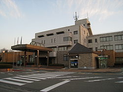
827:
421:
404:
1285:
1165:
686:
180:
168:
48:
1234:
950:
659:
1300:
1192:
1079:
357:
209:
854:
1124:
792:
606:
376:
of 660 persons per km. The total area of the town is 29.68 square kilometres (11.46 sq mi).
922:
889:
859:
192:
629:
to a significant percentage of the working population, who commute to nearby
Saitama City or Tokyo.
1273:
968:
259:
1312:
1144:
935:
894:
879:
874:
869:
813:
731:
393:
373:
361:
204:
197:
1295:
1290:
1244:
1222:
1202:
1197:
1175:
1114:
1064:
1049:
1029:
1009:
999:
958:
899:
884:
669:
651:
626:
399:
1239:
1227:
1129:
1089:
1044:
930:
864:
785:
1278:
1217:
1185:
1170:
1139:
1134:
1094:
1039:
1034:
1014:
1004:
409:
655:
185:
1324:
1249:
1212:
1180:
1109:
1099:
1084:
1054:
994:
846:
837:
822:
290:
39:
742:
1350:
1119:
1074:
1059:
614:
597:
1261:
718:
601:
369:
151:
138:
940:
250:
1069:
757:
1024:
1019:
963:
973:
769:
625:
The economy of
Namegawa is largely agricultural, although it is also a
318:
1104:
280:
255:
328:
365:
327:
173:
989:
453:
270:
781:
448:
368:. As of 1 January 2021, the town had an estimated
308:
750-1 Fukuda, Namekawa-machi, Hiki-gun, Saitama-ken 355-8585
600:
form of government with a directly elected mayor and a
1153:
982:
949:
921:
845:
836:
312:
304:
296:
286:
276:
266:
249:
241:
233:
228:
220:
215:
203:
191:
179:
167:
21:
347:
341:
27:
793:
8:
439:
842:
800:
786:
778:
438:
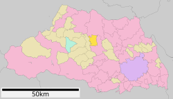
93:Location of Namegawa in Saitama Prefecture
18:
710:
699:Musashi Kyūryō National Government Park
332:Musashi Kyūryō National Government Park
311:
295:
248:
227:
214:
166:
131:
97:
85:
57:
45:
1338:List of mergers in Saitama Prefecture
303:
285:
275:
265:
240:
232:
224:29.68 km (11.46 sq mi)
219:
202:
190:
178:
7:
719:"Namegawa town official statistics"
372:of 19,594 in 8029 households and a
14:
912:
808:
756:
681:
650:
111:
110:
103:
87:
72:
62:
47:
743:Namegawa population statistics
1:
1362:Towns in Saitama Prefecture
348:
1383:
389:Surrounding municipalities
1335:
910:
820:
466:—
422:humid subtropical climate
342:
245:660/km (1,700/sq mi)
132:
98:
86:
58:
46:
37:
28:
152:36.066000°N 139.360972°E
25:
1269:Kitakatsushika District
687:National Route 254
1367:Hiki District, Saitama
1308:Minamisaitama District
333:
765:at Wikimedia Commons
732:Namegawa climate data
721:(in Japanese). Japan.
607:Saitama 10th district
440:Historical population
331:
157:36.066000; 139.360972
242: • Density
53:Namegawa town office
16:Town in Kantō, Japan
1257:Kitaadachi District
441:
260:Japan Standard Time
148: /
814:Saitama Prefecture
394:Saitama Prefecture
374:population density
362:Saitama Prefecture
334:
234: • Total
221: • Total
1357:Namegawa, Saitama
1344:
1343:
1161:Chichibu District
908:
907:
831:
763:Namegawa, Saitama
761:Media related to
693:Local attractions
627:bedroom community
580:
579:
326:
325:
297:Phone number
1374:
1045:Higashimatsuyama
916:
843:
825:
812:
802:
795:
788:
779:
774:
770:Official Website
760:
745:
740:
734:
729:
723:
722:
715:
685:
684:
654:
455:
450:
442:
355:
354:
351:
345:
344:
322:
321:
319:Official website
163:
162:
160:
159:
158:
153:
149:
146:
145:
144:
141:
114:
113:
107:
91:
76:
66:
51:
32:
31:
30:
19:
1382:
1381:
1377:
1376:
1375:
1373:
1372:
1371:
1347:
1346:
1345:
1340:
1331:
1286:Kodama District
1166:Higashichichibu
1149:
978:
945:
917:
904:
832:
816:
806:
772:
754:
749:
748:
741:
737:
730:
726:
717:
716:
712:
707:
695:
682:
678:
648:
643:
635:
623:
596:Namegawa has a
594:
585:
434:
420:Namegawa has a
418:
405:Higshimatsuyama
391:
382:
352:
339:
317:
316:
156:
154:
150:
147:
142:
139:
137:
135:
134:
128:
127:
126:
125:
122:
121:
120:
119:
115:
94:
82:
81:
80:
79:
70:
69:
54:
42:
33:
26:
24:
17:
12:
11:
5:
1380:
1378:
1370:
1369:
1364:
1359:
1349:
1348:
1342:
1341:
1336:
1333:
1332:
1330:
1329:
1328:
1327:
1320:Ōsato District
1317:
1316:
1315:
1305:
1304:
1303:
1298:
1293:
1283:
1282:
1281:
1276:
1266:
1265:
1264:
1254:
1253:
1252:
1247:
1242:
1235:Iruma District
1232:
1231:
1230:
1225:
1220:
1215:
1210:
1205:
1200:
1190:
1189:
1188:
1183:
1178:
1173:
1168:
1157:
1155:
1151:
1150:
1148:
1147:
1142:
1137:
1132:
1127:
1122:
1117:
1112:
1107:
1102:
1097:
1092:
1087:
1082:
1077:
1072:
1067:
1062:
1057:
1052:
1047:
1042:
1037:
1032:
1027:
1022:
1017:
1012:
1007:
1002:
997:
992:
986:
984:
980:
979:
977:
976:
971:
966:
961:
955:
953:
951:Special cities
947:
946:
944:
943:
938:
933:
927:
925:
919:
918:
911:
909:
906:
905:
903:
902:
897:
892:
887:
882:
877:
872:
867:
862:
857:
851:
849:
840:
834:
833:
821:
818:
817:
807:
805:
804:
797:
790:
782:
776:
775:
753:
752:External links
750:
747:
746:
735:
724:
709:
708:
706:
703:
702:
701:
694:
691:
690:
689:
677:
674:
673:
672:
660:Tōbu Tōjō Line
647:
644:
642:
641:Transportation
639:
634:
631:
622:
619:
593:
590:
584:
581:
578:
577:
574:
571:
567:
566:
563:
560:
556:
555:
552:
549:
545:
544:
541:
538:
534:
533:
530:
527:
523:
522:
519:
516:
512:
511:
508:
505:
501:
500:
497:
494:
490:
489:
486:
483:
479:
478:
475:
472:
468:
467:
464:
461:
457:
456:
451:
446:
433:
430:
417:
414:
413:
412:
407:
402:
390:
387:
381:
378:
349:Namegawa-machi
324:
323:
314:
310:
309:
306:
302:
301:
298:
294:
293:
291:Green pheasant
288:
284:
283:
278:
274:
273:
268:
264:
263:
253:
247:
246:
243:
239:
238:
235:
231:
230:
226:
225:
222:
218:
217:
213:
212:
207:
201:
200:
195:
189:
188:
183:
177:
176:
171:
165:
164:
130:
129:
123:
117:
116:
109:
108:
102:
101:
100:
99:
96:
95:
92:
84:
83:
77:
71:
67:
61:
60:
59:
56:
55:
52:
44:
43:
38:
35:
34:
22:
15:
13:
10:
9:
6:
4:
3:
2:
1379:
1368:
1365:
1363:
1360:
1358:
1355:
1354:
1352:
1339:
1334:
1326:
1323:
1322:
1321:
1318:
1314:
1311:
1310:
1309:
1306:
1302:
1299:
1297:
1294:
1292:
1289:
1288:
1287:
1284:
1280:
1277:
1275:
1272:
1271:
1270:
1267:
1263:
1260:
1259:
1258:
1255:
1251:
1248:
1246:
1243:
1241:
1238:
1237:
1236:
1233:
1229:
1226:
1224:
1221:
1219:
1216:
1214:
1211:
1209:
1206:
1204:
1201:
1199:
1196:
1195:
1194:
1193:Hiki District
1191:
1187:
1184:
1182:
1179:
1177:
1174:
1172:
1169:
1167:
1164:
1163:
1162:
1159:
1158:
1156:
1152:
1146:
1143:
1141:
1138:
1136:
1133:
1131:
1128:
1126:
1123:
1121:
1118:
1116:
1113:
1111:
1108:
1106:
1103:
1101:
1098:
1096:
1093:
1091:
1088:
1086:
1083:
1081:
1078:
1076:
1073:
1071:
1068:
1066:
1063:
1061:
1058:
1056:
1053:
1051:
1048:
1046:
1043:
1041:
1038:
1036:
1033:
1031:
1028:
1026:
1023:
1021:
1018:
1016:
1013:
1011:
1008:
1006:
1003:
1001:
998:
996:
993:
991:
988:
987:
985:
981:
975:
972:
970:
967:
965:
962:
960:
957:
956:
954:
952:
948:
942:
939:
937:
934:
932:
929:
928:
926:
924:
920:
915:
901:
898:
896:
893:
891:
888:
886:
883:
881:
878:
876:
873:
871:
868:
866:
863:
861:
858:
856:
853:
852:
850:
848:
844:
841:
839:
835:
829:
824:
819:
815:
811:
803:
798:
796:
791:
789:
784:
783:
780:
773:(in Japanese)
771:
768:
767:
766:
764:
759:
751:
744:
739:
736:
733:
728:
725:
720:
714:
711:
704:
700:
697:
696:
692:
688:
680:
679:
675:
671:
667:
664:
663:
662:
661:
657:
653:
645:
640:
638:
632:
630:
628:
620:
618:
616:
615:Diet of Japan
612:
608:
603:
599:
598:mayor-council
591:
589:
582:
575:
572:
569:
568:
564:
561:
558:
557:
553:
550:
547:
546:
542:
539:
536:
535:
531:
528:
525:
524:
520:
517:
514:
513:
509:
506:
503:
502:
498:
495:
492:
491:
487:
484:
481:
480:
476:
473:
470:
469:
465:
462:
459:
458:
452:
447:
444:
443:
437:
431:
429:
427:
423:
415:
411:
408:
406:
403:
401:
398:
397:
396:
395:
388:
386:
379:
377:
375:
371:
367:
363:
359:
350:
338:
330:
320:
315:
307:
299:
292:
289:
282:
279:
272:
269:
261:
257:
254:
252:
244:
236:
223:
211:
208:
206:
199:
196:
194:
187:
184:
182:
175:
172:
170:
161:
143:139°21′39.5″E
133:Coordinates:
106:
90:
75:
65:
50:
41:
36:
20:
1207:
1125:Tsurugashima
755:
738:
727:
713:
656:Tōbu Railway
649:
636:
624:
595:
586:
435:
432:Demographics
425:
419:
392:
383:
336:
335:
300:0493-56-2211
923:Core cities
666:Shinrinkōen
611:lower house
360:located in
155: /
140:36°3′57.6″N
1351:Categories
1274:Matsubushi
969:Tokorozawa
705:References
602:unicameral
592:Government
370:population
229:Population
193:Prefecture
1313:Miyashiro
1154:Districts
1145:Yoshikawa
941:Koshigaya
936:Kawaguchi
670:Tsukinowa
633:Education
588:success.
380:Geography
251:Time zone
1296:Kamisato
1291:Kamikawa
1245:Moroyama
1223:Tokigawa
1208:Namegawa
1203:Kawajima
1198:Hatoyama
1176:Nagatoro
1115:Shiraoka
1065:Kitamoto
1010:Fujimino
1000:Chichibu
964:Kumagaya
959:Kasukabe
860:Iwatsuki
424:(Köppen
400:Kumagaya
337:Namegawa
277:- Flower
205:District
118:Namegawa
23:Namegawa
1240:Miyoshi
1228:Yoshimi
1090:Okegawa
931:Kawagoe
838:Saitama
828:capital
823:Saitama
676:Highway
646:Railway
621:Economy
613:of the
609:of the
583:History
416:Climate
313:Website
305:Address
198:Saitama
169:Country
1301:Misato
1279:Sugito
1218:Ranzan
1186:Yokoze
1171:Minano
1140:Yashio
1135:Warabi
1105:Sayama
1095:Sakado
1080:Misato
1070:Kōnosu
1040:Hidaka
1035:Hasuda
1015:Fukaya
1005:Fujimi
983:Cities
895:Sakura
880:Minuma
875:Minami
870:Midori
576:+13.9%
573:19,732
565:+35.0%
562:17,323
554:+11.0%
551:12,836
543:+24.4%
540:11,566
532:+23.9%
499:+18.1%
410:Ranzan
287:- Bird
281:Azalea
267:- Tree
237:19,594
181:Region
124:
1325:Yorii
1250:Ogose
1213:Ogawa
1181:Ogano
1110:Shiki
1100:Satte
1085:Niiza
1055:Iruma
1050:Honjō
1030:Hanyū
1025:Hannō
1020:Gyōda
995:Asaka
900:Urawa
890:Ōmiya
885:Nishi
847:Wards
570:2020
559:2010
548:2000
537:1990
529:9,295
526:1980
521:−3.6%
518:7,505
515:1970
510:−7.5%
507:7,785
504:1960
496:8,418
493:1950
488:+3.0%
485:7,130
482:1940
477:+5.8%
474:6,924
471:1930
463:6,545
460:1920
366:Japan
356:is a
256:UTC+9
186:Kantō
174:Japan
1130:Wakō
1120:Toda
1075:Kuki
1060:Kazo
990:Ageo
974:Sōka
865:Kita
855:Chūō
449:Pop.
445:Year
358:town
271:Pine
216:Area
210:Hiki
78:Seal
68:Flag
40:Town
1262:Ina
426:Cfa
343:滑川町
29:滑川町
1353::
668:–
658:-
617:.
454:±%
364:,
346:,
830:)
826:(
801:e
794:t
787:v
353:)
340:(
262:)
258:(
Text is available under the Creative Commons Attribution-ShareAlike License. Additional terms may apply.