715:
727:
783:
767:
318:
745:
48:
81:
697:
114:
1002:统计用区划代码 城乡分类代码 名称 350305107201 121 海山村委会 350305107202 220 云万村委会 350305107203 220 岩下村委会 350305107204 220 石盘村委会 350305107205 220 山初村委会 350305107206 220 万峰村委会 350305107207 220 三墩村委会 350305107208 220 西高村委会 350305107209 220 沙洋村委会 350305107210 220 港南村委会 350305107211 220 浮叶村委会 350305107212 220 后叶村委会 350305107213 220 东岱村委会 350305107214 220 小日村委会 350305107215 220 鳌屿村委会 350305107216 220 罗盘村委会 350305107217 220 赤山村委会
714:
325:
121:
88:
55:
677:
The island is heavily involved in the fishing industry, and several fish farms have been established off the coast of the island. The island's mudflats are cultivated for seaweed and kelp production. Other important sectors are tourism and the energy sector. In 2015, a
726:
989:
782:
766:
744:
1065:
1026:
1182:
817:
47:
1172:
696:
80:
338:
1083:
183:
317:
1137:
113:
1112:
359:
405:
351:
813:"Coordination of Marine Functional Zoning Revision at the Provincial and Municipal Levels: A Case Study of Putian, China"
811:
Huang, Faming; Lin, Yanhong; Liang, Huixin; Zhao, Rongrong; Chen, Qiuming; Lin, Jie; Huang, Jinliang (3 December 2019).
428:; the engagement ended in an ROC victory and resulted in the ROC occupying Nanri. However, ROC forces later withdrew to
421:
1177:
983:
1014:
988:[2018 Statistical Area Numbers and Rural-Urban Area Numbers: Nanri Town] (in Simplified Chinese).
789:
425:
417:
899:南日岛古称南匿山,又名南日山,{...}全镇陆域总面积56平方千米,由111个岛屿组成,面积在0.1平方千米以上的岛屿有18个,有"十八列岛"之称,较大的有小日、鳌屿、罗盘、赤山等岛。{...}全岛有17个村,
251:
949:
1084:"Total fishery output in Nanri Island of SE China's Fujian up 6.2 percent - Xinhua | English.news.cn"
298:
1041:
1091:
913:
874:
1145:
1059:
1018:
1022:
850:
826:
773:
757:
263:
239:
1187:
846:
408:
which includes 111 islands and islets. The island has more than 50 thousand inhabitants.
393:
268:
159:
440:
The town of Nanri (which includes nearby islands) is divided into seventeen villages:
1166:
588:
155:
275:
633:
622:
605:
594:
579:
568:
557:
546:
535:
524:
513:
502:
491:
480:
469:
458:
447:
198:
185:
679:
290:
1138:"In pics: wind farm on SE China's Nanri Island - Xinhua | English.news.cn"
973:, 1950-1979 By Bruce A. Elleman p60 Naval War College Newport Papers. 2012
831:
812:
636:
625:
608:
597:
582:
571:
560:
549:
538:
527:
516:
505:
494:
483:
472:
461:
450:
429:
401:
397:
302:
256:
244:
167:
163:
432:, and the island was re-occupied by the People's Republic of China.
720:
Map of the area including Lamyit I. (Nanjih or Nanri Island) (1880)
950:"Islands ecological integrity evaluation using multi sources data"
948:
Jiang, Mengzhen; Pang, Xiaoping; Wang, Jianjun; Cao, Chao (2018).
230:
171:
990:
National Bureau of
Statistics of the People's Republic of China
772:
Map including Nanri Island (labeled as Nan-jih Tao (Lam Yit)) (
1113:"Nanri Island Offshore Wind Power Project | Reconnecting Asia"
386:), is a small island off the coast of China. Nanri Town (
788:
Map including Nanri Island (labeled as NANRI DAO) (
750:Map including Nanri Island (labeled as NAN-JIH TAO
289:
284:
274:
262:
250:
238:
222:
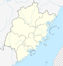
214:
177:
150:
145:
24:
158:, southeast of the Asian mainland in Nanri Town,
857:Nanjisü{...}Nanjisü, Fukien . . 25.14 N 119.30 E
732:Japanese map including Nanri Island (labeled as
416:In October 1952, the island was the site of the
733:
943:
941:
920:
897:
881:
751:
703:
664:
658:
652:
646:
631:
620:
614:
603:
592:
577:
566:
555:
544:
533:
522:
511:
500:
489:
478:
467:
456:
445:
387:
381:
375:
29:
8:
19:
1064:: CS1 maint: numeric names: authors list (
1042:"Fishing farms around NanRi Island, China"
18:
971:High Seas Buffer: The Taiwan Patrol Force
926:(in Simplified Chinese). 7 September 2017
887:(in Simplified Chinese). 7 September 2017
830:
818:Journal of Marine Science and Engineering
645:Other populated places include Fou-tou (
869:
867:
865:
803:
702:Map including Nanri Island (labeled as
692:
1057:
1027:Perry–Castañeda Library Map Collection
657:), Hsi-kao, Ts'ao-hu, T'ou-ying-shih (
1077:
1075:
7:
374:, historically known as Nanni Shan (
324:
120:
87:
54:
218:42.1 km (16.3 sq mi)
1183:Township-level divisions of Fujian
669:), Shih-t'ou-p'an and Shang-t'ou.
14:
1040:Alerts | 29/09/15 (2015-09-29).
781:
765:
743:
725:
713:
695:
323:
316:
119:
112:
86:
79:
53:
46:
855:(1 ed.). pp. 24, 82.
682:was established on the island.
392:) is an administrative unit of
1173:Islands of the South China Sea
954:Ocean & Coastal Management
921:
898:
882:
792:, compiled 1971, revised 1996)
752:
704:
632:
621:
615:
604:
593:
578:
567:
556:
545:
534:
523:
512:
501:
490:
479:
468:
457:
446:
388:
363:
355:
30:
1:
690:Maps including Nanri Island:
100:Nanri Island (Southeast Asia)
67:Location in the Taiwan Strait
27:
852:Atlas of the Chinese Empire
613:, also known as Ta-ao Hsü (
70:Show map of South China Sea
1204:
1017:(in English and Chinese).
406:People's Republic of China
103:Show map of Southeast Asia
1117:reconnectingasia.csis.org
734:
665:
659:
653:
647:
382:
376:
227:
40:
984:
914:
875:
436:Administrative divisions
422:People's Liberation Army
342:Location of Nanri Island
199:25.202288°N 119.498077°E
985:2018年统计用区划代码和城乡划分代码:南日镇
426:Republic of China Army
418:Battle of Nanri Island
285:Additional information
252:Prefecture-level city
204:25.202288; 119.498077
1015:"NG 50-12 P'U-T'IEN"
339:class=notpageimage|
1025:. 1954 – via
832:10.3390/jmse7120442
360:traditional Chinese
195: /
133:Nanri Island (Asia)
21:
380:) and Nanri Shan (
352:simplified Chinese
1178:Islands of Fujian
1142:www.xinhuanet.com
1094:on March 22, 2019
1088:www.xinhuanet.com
1019:Washington, D. C.
312:
311:
1195:
1157:
1156:
1154:
1153:
1148:on March 4, 2019
1144:. Archived from
1133:
1127:
1126:
1124:
1123:
1109:
1103:
1102:
1100:
1099:
1090:. Archived from
1079:
1070:
1069:
1063:
1055:
1053:
1052:
1037:
1031:
1030:
1023:Army Map Service
1011:
1005:
1004:
999:
997:
980:
974:
968:
962:
961:
945:
936:
935:
933:
931:
924:
923:
910:
904:
903:
901:
900:
894:
892:
885:
884:
871:
860:
859:
843:
837:
836:
834:
808:
785:
769:
755:
754:
747:
737:
736:
729:
717:
707:
706:
699:
668:
667:
662:
661:
656:
655:
650:
649:
640:
639:
629:
628:
618:
617:
612:
611:
601:
600:
586:
585:
575:
574:
564:
563:
553:
552:
542:
541:
531:
530:
520:
519:
509:
508:
498:
497:
487:
486:
476:
475:
465:
464:
454:
453:
391:
390:
385:
384:
379:
378:
365:
357:
327:
326:
320:
210:
209:
207:
206:
205:
200:
196:
193:
192:
191:
188:
137:
136:Show map of Asia
123:
122:
116:
104:
90:
89:
83:
71:
57:
56:
50:
34:
33:
32:
22:
16:Island of Fujian
1203:
1202:
1198:
1197:
1196:
1194:
1193:
1192:
1163:
1162:
1161:
1160:
1151:
1149:
1135:
1134:
1130:
1121:
1119:
1111:
1110:
1106:
1097:
1095:
1081:
1080:
1073:
1056:
1050:
1048:
1039:
1038:
1034:
1013:
1012:
1008:
995:
993:
986:
982:
981:
977:
969:
965:
947:
946:
939:
929:
927:
916:
912:
911:
907:
890:
888:
877:
873:
872:
863:
847:Edward Stanford
845:
844:
840:
810:
809:
805:
800:
793:
786:
777:
770:
761:
748:
739:
730:
721:
718:
709:
700:
688:
675:
438:
414:
345:
344:
343:
341:
335:
334:
333:
332:
328:
308:
234:
203:
201:
197:
194:
189:
186:
184:
182:
181:
141:
140:
139:
138:
135:
134:
131:
130:
129:
128:
124:
107:
106:
105:
102:
101:
98:
97:
96:
95:
91:
74:
73:
72:
69:
68:
65:
64:
63:
62:
58:
36:
35:
28:
17:
12:
11:
5:
1201:
1199:
1191:
1190:
1185:
1180:
1175:
1165:
1164:
1159:
1158:
1128:
1104:
1071:
1032:
1006:
975:
963:
937:
905:
861:
838:
802:
801:
799:
796:
795:
794:
787:
780:
778:
771:
764:
762:
749:
742:
740:
731:
724:
722:
719:
712:
710:
701:
694:
687:
684:
674:
671:
663:), Ts'u-shan (
643:
642:
437:
434:
413:
410:
394:Xiuyu District
337:
336:
330:
329:
322:
321:
315:
314:
313:
310:
309:
307:
306:
299:China Standard
295:
293:
287:
286:
282:
281:
278:
272:
271:
266:
260:
259:
254:
248:
247:
242:
236:
235:
228:
225:
224:
223:Administration
220:
219:
216:
212:
211:
179:
175:
174:
160:Xiuyu District
152:
148:
147:
143:
142:
132:
126:
125:
118:
117:
111:
110:
109:
108:
99:
93:
92:
85:
84:
78:
77:
76:
75:
66:
60:
59:
52:
51:
45:
44:
43:
42:
41:
38:
37:
25:
15:
13:
10:
9:
6:
4:
3:
2:
1200:
1189:
1186:
1184:
1181:
1179:
1176:
1174:
1171:
1170:
1168:
1147:
1143:
1139:
1132:
1129:
1118:
1114:
1108:
1105:
1093:
1089:
1085:
1078:
1076:
1072:
1067:
1061:
1047:
1043:
1036:
1033:
1028:
1024:
1020:
1016:
1010:
1007:
1003:
991:
987:
979:
976:
972:
967:
964:
959:
955:
951:
944:
942:
938:
925:
917:
909:
906:
902:
886:
878:
870:
868:
866:
862:
858:
854:
853:
848:
842:
839:
833:
828:
824:
820:
819:
814:
807:
804:
797:
791:
784:
779:
775:
768:
763:
759:
746:
741:
728:
723:
716:
711:
698:
693:
691:
685:
683:
681:
672:
670:
638:
635:
627:
624:
610:
607:
599:
596:
590:
584:
581:
573:
570:
562:
559:
551:
548:
540:
537:
529:
526:
518:
515:
507:
504:
496:
493:
485:
482:
474:
471:
463:
460:
452:
449:
443:
442:
441:
435:
433:
431:
427:
423:
419:
411:
409:
407:
403:
399:
395:
373:
369:
361:
353:
349:
340:
319:
304:
300:
297:
296:
294:
292:
288:
283:
279:
277:
273:
270:
267:
265:
261:
258:
255:
253:
249:
246:
243:
241:
237:
233:
232:
226:
221:
217:
213:
208:
180:
176:
173:
169:
165:
161:
157:
156:Taiwan Strait
153:
149:
144:
115:
82:
49:
39:
26:Native name:
23:
1150:. Retrieved
1146:the original
1141:
1131:
1120:. Retrieved
1116:
1107:
1096:. Retrieved
1092:the original
1087:
1049:. Retrieved
1045:
1035:
1009:
1001:
994:. Retrieved
978:
970:
966:
957:
953:
928:. Retrieved
919:
908:
896:
889:. Retrieved
880:
856:
851:
841:
822:
816:
806:
689:
676:
644:
630:), Chishan (
619:)), Luopan (
576:), Dongdai (
543:), Gangnan (
532:), Shayang (
499:), Wanfeng (
488:), Shanchu (
439:
420:between the
415:
371:
367:
348:Nanri Island
347:
346:
331:Nanri Island
229:
127:Nanri Island
94:Nanri Island
61:Nanri Island
20:Nanri Island
996:15 February
891:10 February
651:), Hsi-hu (
510:), Sandun (
477:), Shipan (
466:), Yanxia (
455:), Yunwan (
202: /
190:119°29′53″E
178:Coordinates
1167:Categories
1152:2019-03-24
1122:2019-03-22
1098:2019-03-22
1051:2019-03-22
1046:SAFETY4SEA
960:: 134–143.
930:8 February
922:莆田市秀屿区人民政府
883:莆田市秀屿区人民政府
798:References
565:), Houye (
521:), Xigao (
350:(Chinese:
187:25°12′08″N
825:(12): 5.
680:wind farm
602:), Aoyu (
554:), Fuye (
444:Haishan (
291:Time zone
146:Geography
1060:cite web
849:(1908).
738:) (1943)
424:and the
264:District
240:Province
151:Location
776:, 1954)
760:, 1954)
686:Gallery
673:Economy
412:History
368:Nanjisü
154:In the
1188:Putian
992:. 2018
589:Xiaori
430:Taiwan
402:Fujian
398:Putian
372:Nanjih
362::
354::
257:Putian
245:Fujian
168:Fujian
164:Putian
1082:苗明媚.
303:UTC+8
280:Nanri
269:Xiuyu
231:China
172:China
1136:杨懿.
1066:link
998:2020
932:2020
915:海岛资源
893:2020
276:Town
215:Area
958:158
876:南日镇
827:doi
790:DMA
774:AMS
758:AMS
756:) (
753:南日島
735:南日島
705:南日嶼
660:頭英石
616:大嶅㠘
587:),
389:南日镇
383:南日山
377:南匿山
366:),
364:南日島
356:南日岛
31:南日岛
1169::
1140:.
1115:.
1086:.
1074:^
1062:}}
1058:{{
1044:.
1021::
1000:.
956:.
952:.
940:^
918:.
895:.
879:.
864:^
821:.
815:.
666:粗山
654:西户
648:浮斗
634:赤山
623:罗盘
606:鳌屿
595:小日
580:东岱
569:后叶
558:浮叶
547:港南
536:沙洋
525:西高
514:三墩
503:万峰
492:山初
481:石盘
470:岩下
459:云万
448:海山
404:,
400:,
396:,
370:,
358:;
170:,
166:,
162:,
1155:.
1125:.
1101:.
1068:)
1054:.
1029:.
934:.
835:.
829::
823:7
708:)
641:)
637:村
626:村
609:村
598:村
591:(
583:村
572:村
561:村
550:村
539:村
528:村
517:村
506:村
495:村
484:村
473:村
462:村
451:村
305:)
301:(
Text is available under the Creative Commons Attribution-ShareAlike License. Additional terms may apply.