72:
811:
57:
42:
532:
In the town, the population was spread out, with 21.0% under the age of 18, 9.9% from 18 to 24, 28.5% from 25 to 44, 24.3% from 45 to 64, and 16.3% who were 65 years of age or older. The median age was 39 years. For every 100 females, there were 99.0 males. For every 100 females age 18 and over,
528:
living together, 9.8% had a female householder with no husband present, and 39.9% were non-families. 32.8% of all households were made up of individuals, and 13.7% had someone living alone who was 65 years of age or older. The average household size was 2.21 and the average family size was 2.85.
492:
of 2000, there were 404 people, 183 households, and 109 families residing in the town. The population density was 1,520.7 inhabitants per square mile (587.1/km). There were 234 housing units at an average density of 880.8 per square mile (340.1/km). The racial makeup of the town was 85.40%
71:
536:
The median income for a household in the town was $ 27,868, and the median income for a family was $ 45,179. Males had a median income of $ 29,375 versus $ 19,583 for females. The
1026:
727:
85:
243:
1016:
253:
321:
720:
56:
218:
561:
676:
713:
583:
903:
705:
656:
587:
518:
514:
510:
506:
502:
498:
494:
139:
41:
1021:
465:
450:
435:
420:
405:
390:
310:'s city limits, the adjacent housing units and other buildings constitute the incorporated town of Napier Field.
287:
117:
870:
524:
There were 183 households, out of which 24.0% had children under the age of 18 living with them, 44.3% were
303:
631:
986:
963:
958:
845:
795:
993:
835:
737:
291:
279:
228:
144:
953:
888:
789:
778:
353:
609:
860:
537:
295:
540:
for the town was $ 18,769. About 6.2% of families and 11.8% of the population were below the
923:
918:
299:
948:
938:
913:
908:
898:
855:
840:
830:
783:
307:
943:
933:
800:
759:
1010:
928:
878:
541:
752:
127:
691:
678:
336:
323:
100:
87:
632:"Annual Estimates of the Resident Population: April 1, 2010 to July 1, 2013"
209:
544:, including 18.4% of those under age 18 and 12.3% of those age 65 or over.
356:, the town has a total area of 0.3 square miles (0.78 km), all land.
977:‡This populated place also has portions in an adjacent county or counties
525:
283:
132:
489:
235:
214:
513:, and 2.23% from two or more races. 2.72% of the population were
822:
770:
32:
810:
709:
267:
809:
652:
972:
887:
869:
821:
769:
263:
252:
242:
225:
208:
200:
192:
187:
179:
171:
163:
155:
150:
138:
126:
116:
23:
76:Location of Napier Field in Dale County, Alabama.
721:
8:
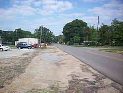
290:, the population was 409. It is part of the
294:. The town was originally constructed as a
728:
714:
706:
584:"US Gazetteer files: 2010, 2000, and 1990"
363:
20:
306:. While the airport itself lies within
814:Map of Alabama highlighting Dale County
553:
262:
241:
207:
186:
178:
149:
115:
80:
68:
50:
38:
383:
251:
224:
199:
191:
170:
162:
154:
137:
125:
7:
292:Ozark micropolitan statistical area
175:0.00 sq mi (0.00 km)
167:0.26 sq mi (0.66 km)
159:0.26 sq mi (0.66 km)
1027:Enterprise–Ozark micropolitan area
736:Municipalities and communities of
373:
14:
70:
55:
40:
204:1,597.66/sq mi (617.36/km)
302:. It is currently adjacent to
18:Town in Alabama, United States
1:
1017:Towns in Dale County, Alabama
564:. United States Census Bureau
657:United States Census Bureau
588:United States Census Bureau
562:"2020 U.S. Gazetteer Files"
318:Napier Field is located at
1043:
268:http://www.napierfield.com
982:
807:
750:
479:
464:
449:
434:
419:
404:
389:
382:
377:
372:
369:
349:(31.315265, -85.454340).
81:
69:
51:
39:
30:
183:374 ft (114 m)
610:"U.S. Decennial Census"
533:there were 92.2 males.
304:Dothan Regional Airport
815:
692:31.315265°N 85.45434°W
813:
653:"U.S. Census website"
480:U.S. Decennial Census
365:Historical population
337:31.31528°N 85.45444°W
227: • Summer (
101:31.31528°N 85.45444°W
46:Napier Field, Alabama
25:Napier Field, Alabama
995:United States portal
739:Dale County, Alabama
697:31.315265; -85.45434
298:air base during the
201: • Density
688: /
590:. February 12, 2011
366:
342:31.31528; -85.45444
333: /
106:31.31528; -85.45444
97: /
816:
364:
354:U.S. Census Bureau
193: • Total
172: • Water
156: • Total
1004:
1003:
538:per capita income
486:
485:
352:According to the
273:
272:
164: • Land
1034:
1022:Towns in Alabama
996:
989:
812:
762:
755:
745:
740:
730:
723:
716:
707:
703:
702:
700:
699:
698:
693:
689:
686:
685:
684:
681:
668:
667:
665:
663:
649:
643:
642:
640:
638:
628:
622:
621:
619:
617:
606:
600:
599:
597:
595:
580:
574:
573:
571:
569:
558:
503:African American
385:
380:
375:
367:
348:
347:
345:
344:
343:
338:
334:
331:
330:
329:
326:
300:Second World War
232:
112:
111:
109:
108:
107:
102:
98:
95:
94:
93:
90:
74:
59:
44:
21:
1042:
1041:
1037:
1036:
1035:
1033:
1032:
1031:
1007:
1006:
1005:
1000:
994:
987:
978:
968:
890:
889:Unincorporated
883:
865:
817:
805:
765:
760:
753:
746:
743:
738:
734:
696:
694:
690:
687:
682:
679:
677:
675:
674:
672:
671:
661:
659:
651:
650:
646:
636:
634:
630:
629:
625:
615:
613:
608:
607:
603:
593:
591:
582:
581:
577:
567:
565:
560:
559:
555:
550:
526:married couples
507:Native American
481:
378:
362:
341:
339:
335:
332:
327:
324:
322:
320:
319:
316:
226:
105:
103:
99:
96:
91:
88:
86:
84:
83:
77:
65:
64:
63:
62:
47:
35:
26:
19:
12:
11:
5:
1040:
1038:
1030:
1029:
1024:
1019:
1009:
1008:
1002:
1001:
999:
998:
991:
988:Alabama portal
983:
980:
979:
976:
974:
970:
969:
967:
966:
961:
956:
951:
946:
941:
936:
931:
926:
921:
916:
911:
906:
901:
895:
893:
885:
884:
882:
881:
875:
873:
867:
866:
864:
863:
858:
853:
848:
843:
838:
833:
827:
825:
819:
818:
808:
806:
804:
803:
798:
793:
787:
781:
775:
773:
767:
766:
751:
748:
747:
735:
733:
732:
725:
718:
710:
670:
669:
644:
623:
601:
575:
552:
551:
549:
546:
484:
483:
477:
476:
473:
471:
468:
462:
461:
458:
456:
453:
447:
446:
443:
441:
438:
432:
431:
428:
426:
423:
417:
416:
413:
411:
408:
402:
401:
398:
396:
393:
387:
386:
381:
376:
371:
361:
358:
315:
312:
271:
270:
265:
261:
260:
257:
250:
249:
246:
240:
239:
233:
223:
222:
212:
206:
205:
202:
198:
197:
194:
190:
189:
185:
184:
181:
177:
176:
173:
169:
168:
165:
161:
160:
157:
153:
152:
148:
147:
142:
136:
135:
130:
124:
123:
120:
114:
113:
79:
78:
75:
67:
66:
60:
54:
53:
52:
49:
48:
45:
37:
36:
31:
28:
27:
24:
17:
13:
10:
9:
6:
4:
3:
2:
1039:
1028:
1025:
1023:
1020:
1018:
1015:
1014:
1012:
997:
992:
990:
985:
984:
981:
975:
971:
965:
962:
960:
957:
955:
952:
950:
947:
945:
942:
940:
937:
935:
932:
930:
927:
925:
922:
920:
917:
915:
912:
910:
907:
905:
902:
900:
897:
896:
894:
892:
886:
880:
877:
876:
874:
872:
868:
862:
859:
857:
854:
852:
849:
847:
844:
842:
839:
837:
834:
832:
829:
828:
826:
824:
820:
802:
799:
797:
794:
791:
788:
785:
782:
780:
777:
776:
774:
772:
768:
764:
763:
756:
749:
744:United States
741:
731:
726:
724:
719:
717:
712:
711:
708:
704:
701:
658:
654:
648:
645:
633:
627:
624:
611:
605:
602:
589:
585:
579:
576:
563:
557:
554:
547:
545:
543:
539:
534:
530:
527:
522:
521:of any race.
520:
516:
512:
509:, 0.74% from
508:
504:
500:
496:
491:
482:2013 Estimate
478:
474:
472:
469:
467:
463:
459:
457:
454:
452:
448:
444:
442:
439:
437:
433:
429:
427:
424:
422:
418:
414:
412:
409:
407:
403:
399:
397:
394:
392:
388:
368:
359:
357:
355:
350:
346:
313:
311:
309:
305:
301:
297:
293:
289:
285:
281:
278:is a town in
277:
269:
266:
258:
255:
247:
245:
237:
234:
230:
220:
219:Central (CST)
216:
213:
211:
203:
195:
182:
174:
166:
158:
146:
143:
141:
134:
131:
129:
122:United States
121:
119:
110:
82:Coordinates:
73:
58:
43:
34:
29:
22:
16:
964:Sylvan Grove
959:Skipperville
879:Fort Novosel
851:Napier Field
850:
846:Midland City
796:Level Plains
758:
673:
660:. Retrieved
647:
635:. Retrieved
626:
614:. Retrieved
612:. Census.gov
604:
592:. Retrieved
578:
566:. Retrieved
556:
542:poverty line
535:
531:
523:
487:
360:Demographics
351:
317:
276:Napier Field
275:
274:
15:
891:communities
836:Clayhatchee
754:County seat
695: /
662:January 31,
568:October 29,
511:other races
340: /
288:2020 census
280:Dale County
104: /
1011:Categories
954:Rocky Head
790:Enterprise
683:85°27′16″W
680:31°18′55″N
548:References
488:As of the
328:85°27′16″W
325:31°18′55″N
256:feature ID
188:Population
92:85°27′16″W
89:31°18′55″N
973:Footnotes
779:Daleville
594:April 23,
497:, 11.39%
314:Geography
286:. At the
244:FIPS code
210:Time zone
180:Elevation
861:Pinckard
515:Hispanic
505:, 0.25%
296:military
248:01-53256
924:Dillard
919:Clopton
637:June 3,
616:June 6,
284:Alabama
264:Website
259:0123635
133:Alabama
118:Country
949:Mabson
939:Gerald
914:Bertha
909:Barnes
904:Asbury
899:Arguta
856:Newton
841:Grimes
831:Ariton
784:Dothan
771:Cities
519:Latino
490:census
460:−12.4%
445:−12.6%
415:−13.8%
370:Census
308:Dothan
140:County
944:Kelly
934:Ewell
823:Towns
801:Ozark
761:Ozark
499:Black
495:White
475:15.5%
430:−6.3%
238:(CDT)
236:UTC-5
215:UTC-6
128:State
929:Echo
664:2008
639:2014
618:2013
596:2011
570:2021
466:2020
451:2010
436:2000
421:1990
406:1980
391:1970
379:Note
374:Pop.
254:GNIS
151:Area
145:Dale
61:Flag
33:Town
871:CDP
517:or
501:or
470:409
455:354
440:404
425:462
410:493
395:572
229:DST
196:409
1013::
757::
742:,
655:.
586:.
384:%±
282:,
792:‡
786:‡
729:e
722:t
715:v
666:.
641:.
620:.
598:.
572:.
400:—
231:)
221:)
217:(
Text is available under the Creative Commons Attribution-ShareAlike License. Additional terms may apply.