39:
263:
The Narrow Vein is one of the two major slate veins in Mid Wales that were commercially quarried. Narrow Vein rock is generally more splittable than Broad Vein rock and was often used to make roofing slates.
255:
The formation is exposed in a number of locations in Mid Wales where glacial valleys cut across it. It is especially visible in the quarries along its length
136:
235:
in several locations along its length. The formation is between 400 metres (1,300 ft) and 560 metres (1,840 ft) thick and runs from
424:
434:
402:
38:
439:
429:
84:
129:
372:
288:
74:
296:
216:
56:
301:
44:
334:
329:
398:
325:
213:
304:
which worked from the 14th. century until 2002. Also worked the Broad Vein. Connected to the
279:
344:
314:
340:
319:
310:
305:
284:
231:. It generally a medium blue colour. This formation has been commercially quarried as
418:
236:
189:
26:
364:
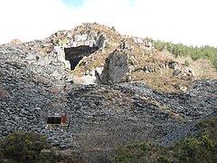
292:
240:
271:
220:
275:
210:
30:
151:
138:
224:
171:
228:
107:
322:, which mainly worked the Narrow Vein, connected to the Ratgoed Tramway
227:. The rock of the formation is silty, homogeneous or finely-laminated
244:
232:
193:
117:
395:
The Slate
Regions of North and Mid Wales and Their Railways
267:
The Narrow Vein was quarried in the following locations:
94:
400 metres (1,300 ft) to 560 metres (1,840 ft)
185:
177:
167:
128:
123:
113:
103:
98:
90:
80:
70:
62:
52:
20:
8:
47:showing the main working of the Narrow Vein
337:, also connected to the Hendre-Ddu Tramway
37:
17:
356:
328:a smaller operation connected to the
7:
278:was also worked, connected to the
14:
369:BGS on-line lexicon of rock units
365:"Narrow Vein Mudstone Formation"
203:Narrow Vein Mudstone Formation
21:Narrow Vein Mudstone Formation
1:
85:Broad Vein Mudstone Formation
393:Richards, Alun John (1999).
425:Ordovician System of Europe
456:
373:British Geological Survey
36:
25:
435:Rock formations of Wales
440:Slate industry in Wales
430:Upper Ordovician Series
397:. Gwasg Carreg Gwalch.
205:(commonly known as the
75:Garnedd-Wen Formation
297:Upper Corris Tramway
259:Commercial quarrying
313:, connected to the
302:Aberllefenni Quarry
295:, connected to the
148: /
45:Aberllefenni Quarry
27:Stratigraphic range
335:Gartheiniog quarry
330:Hendre-Ddu Tramway
214:lithostratigraphic
152:52.6757°N 3.8230°W
343:connected to the
326:Hendre Ddu quarry
199:
198:
447:
409:
408:
390:
384:
383:
381:
379:
361:
280:Talyllyn Railway
163:
162:
160:
159:
158:
157:52.6757; -3.8230
153:
149:
146:
145:
144:
141:
66:Abercorris Group
41:
18:
455:
454:
450:
449:
448:
446:
445:
444:
415:
414:
413:
412:
405:
392:
391:
387:
377:
375:
363:
362:
358:
353:
345:Mawddwy Railway
315:Ratgoed Tramway
261:
253:
219:(a sequence of
156:
154:
150:
147:
142:
139:
137:
135:
134:
48:
12:
11:
5:
453:
451:
443:
442:
437:
432:
427:
417:
416:
411:
410:
403:
385:
355:
354:
352:
349:
348:
347:
341:Minllyn quarry
338:
332:
323:
320:Ratgoed quarry
317:
311:Cymerau Quarry
308:
306:Corris Railway
299:
282:
260:
257:
252:
249:
239:south-west to
197:
196:
187:
183:
182:
179:
175:
174:
169:
165:
164:
132:
126:
125:
121:
120:
115:
111:
110:
105:
101:
100:
96:
95:
92:
88:
87:
82:
78:
77:
72:
68:
67:
64:
60:
59:
54:
50:
49:
42:
34:
33:
23:
22:
13:
10:
9:
6:
4:
3:
2:
452:
441:
438:
436:
433:
431:
428:
426:
423:
422:
420:
406:
404:0-86381-552-9
400:
396:
389:
386:
374:
370:
366:
360:
357:
350:
346:
342:
339:
336:
333:
331:
327:
324:
321:
318:
316:
312:
309:
307:
303:
300:
298:
294:
290:
286:
283:
281:
277:
273:
270:
269:
268:
265:
258:
256:
250:
248:
246:
242:
238:
237:Dinas Mawddwy
234:
230:
226:
222:
218:
215:
212:
208:
204:
195:
191:
190:Dinas Mawddwy
188:
184:
180:
176:
173:
170:
166:
161:
133:
131:
127:
122:
119:
116:
112:
109:
106:
102:
97:
93:
89:
86:
83:
79:
76:
73:
69:
65:
61:
58:
55:
51:
46:
40:
35:
32:
28:
24:
19:
16:
394:
388:
378:11 September
376:. Retrieved
368:
359:
293:Corris Uchaf
291:quarries in
266:
262:
254:
241:Cardigan Bay
206:
202:
200:
15:
272:Bryn Eglwys
221:rock strata
207:Narrow Vein
155: /
130:Coordinates
419:Categories
351:References
289:Braichgoch
276:Broad Vein
274:where the
211:Ordovician
140:52°40′33″N
31:Hirnantian
225:Mid Wales
172:Mid Wales
143:3°49′23″W
99:Lithology
91:Thickness
71:Underlies
251:Outcrops
229:mudstone
209:) is an
124:Location
108:Mudstone
81:Overlies
285:Gaewern
178:Country
104:Primary
63:Unit of
401:
186:Extent
168:Region
245:Tywyn
233:slate
223:) in
217:group
194:Tywyn
181:Wales
118:Slate
114:Other
57:Group
399:ISBN
380:2019
287:and
201:The
53:Type
43:The
243:at
192:to
421::
371:.
367:.
247:.
29::
407:.
382:.
Text is available under the Creative Commons Attribution-ShareAlike License. Additional terms may apply.