222:
obvious cable work done in connection with their construction required a cover story explaining them as oceanographic research facilities and that data gathered by oceanographic and acoustic surveys with ships could at times be collected "more expeditiously and more economically by means of shore stations. These are the U. S. Naval
Facilities." The "oceanographic" cover included the entire span of the facility's existence and decommissioning on 30 June 1976 with the SOSUS mission being declassified in 1991.
292:(VFW) leased the recreation building and some three adjacent acres on which they sponsor an annual beach carnival. Many of the Navy buildings and some of the paved roads had been removed after decommissioning of the Naval Facility and the remaining stripped buildings were in poor condition. The Terminal Building was close to collapse onto the beach due to erosion and the VFW building was only 80 ft (24.4 m) from the point of erosion on the coastal bank.
53:
249:
administration building and barracks was requested along with a mess hall and recreation facilities. It was evident that the classified details of the system and its shore terminal was not clear even to some high ranking
Senators as the same request for replacement buildings was met by questions in the Senate Committee as to why it could not be moved to another location, including the
234:
295:
The
Nantucket Parks and Recreation Commission managed the property with the VFW managing its portion and holding public events there. The Nantucket Hunting Association obtained permission to use the bunker in 1995 but it was later used by Parks and Recreation as storage. By 2018 there was interest in
221:
Naval
Facility (NAVFAC) Nantucket was among the first Atlantic systems ordered and installed with the shore facility commissioned 1 August 1955. The facility, along with the entire Atlantic system at the time, was experimental though it quickly became operational. The visible shore installations and
225:
The site, about twelve miles from the town of
Nantucket on Tom Never's Head at the southernmost tip of the island, had been part of the Nantucket Ordnance Site. During World War II the land had been leased by the government from September 1943 through 30 June 1946 for use as the Nantucket Ordnance
248:
housing both the sensitive electronic equipment and eight officers and eighty-nine enlisted men. Within five years the temporary buildings had deteriorated putting the terminal building electronics at risk. The complement had grown to ten officers and ninety-four enlisted men and new combination
275:
The first decommissioning of SOSUS shore stations came in 1976 when the first to be commissioned, Naval
Facility Punta Borinquen (commissioned 18 September 1954 as NAVFAC Ramey), Puerto Rico, was closed on 30 April followed by Naval Facility Nantucket on 30 June.
288: (equivalent to $ 1,941,397 in 2023) with the intent it would be used as a recreation area. The approximately twenty-five acres included over 1,000 ft (304.8 m) of shoreline. Fifteen acres were transferred to the Nantucket Housing Authority and the
260:
The surveillance system shore processing facilities underwent backfits during the late 1960s at the stations replacing original equipment with more modern equipment including moving from electromechanical spectrum analysis to digital.
314:
was a problem, clearly by 1969 and by closure was threatening the
Terminal Building containing all the equipment. After closure the Terminal Building was in danger of toppling onto the beach and was eventually demolished.
827:
513:
842:
771:
822:
331:
This was apparently the local name, predating the establishment of the SOSUS Naval
Facility, applied to the leased ordnance site that was officially the Nantucket Ordnance Site.
195:(SOSUS) active from 1955 to 1976. The true function of the system and the shore terminals, in which output of the array at sea was processed and displayed by means of the
535:
514:
Land Use
Control and Long-Term Management Implementation Plan for Nantucket Beach Formerly Used Defense Site Project No. D01MA045601 Nantucket Island, Massachusetts
359:
837:
847:
237:
196:
700:
206:
on a part of a site that had been used in World War II as an ordinance site and practice bombing range. Locally the facility was sometimes known as the
807:
801:
796:
257:. The Navy again requested funds in 1964 to upgrade facilities to permanent buildings. Fourteen units of family housing were authorized in 1967.
57:
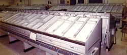
NAVFAC Nantuckett ca. early 1960s after replacement of most
Quonset buildings. Terminal building close to beach (center) in its own compound.
254:
68:
723:
303:
As of 2020 the Town and County of Nantucket shows the Tom Nevers Park owned and managed by the Parks and Recreation Commission.
199:, was classified and the term "Naval Facility" was intentionally vague. Its function was described as oceanographic research.
296:
restoring the bunker as a museum and attraction and there was some interest in obtaining objects that had been used in the
213:
In 1980 the property was sold to the Town of Nantucket and is now a park managed by the Parks and Recreation Commission.
487:
227:
226:
Site (also known as Tom Nevers Rocket Projectile Target) used for as an aerial rocket range by pilots from the
832:
349:
289:
20:
615:
344:
269:
354:
529:
385:
671:
52:
703:(Report). Nantucket, MA: Nantucket Planning & Economic Development Commission. July 6, 1995
593:
571:
549:
437:
297:
250:
311:
265:
641:
816:
43:
574:(Report). Washington, D.C.: U.S. Government Printing Office. 1962. pp. 241–243
552:(Report). Washington, D.C.: U.S. Government Printing Office. 1958. pp. 424–425
440:(Report). Washington, D.C.: U.S. Government Printing Office. 1962. pp. 159–161
748:
245:
596:(Report). Washington, D.C.: U.S. Government Printing Office. 1965. p. 212
35:
772:"Collection photo # 2017.40.01 - aerial view of Naval Facility Nantucket, MA"
268:, to be used in the event of a nuclear attack while President Kennedy was in
83:
70:
512:
ERT, Inc. (for USACE Corps of Engineers, New England District) (July 2018).
203:
39:
300:, which had closed, and associating with former management of that site.
621:(Report). U.S. Government Printing Office. October 21, 1967. p. 303
459:
233:
284:
The Town of Nantucket purchased the property from the Navy in 1980 for
412:
651:. Vol. 6, no. 1. IUSS/CAESAR Alumni Association. p. 3
413:"Integrated Undersea Surveillance System (IUSS) History 1950 - 2010"
232:
192:
103:
202:
The facility was built about twelve miles from the town of
119:
Commander, Oceanographic System Atlantic (COMOCEANSYSLANT)
642:"Evolution of SOSUS/IUSS Signal Processing (Part 1 of 2)"
828:
Installations of the United States Navy in Massachusetts
253:, and why its "oceanographic work" could not be done at
724:"Nantucket nuclear bunker could be new Kennedy museum"
843:
Buildings and structures in Nantucket, Massachusetts
594:
Hearings on Military Construction Authorization 1965
572:
Hearings Before Committee (Senate) on Armed Services
550:
Hearings on Military Construction Authorization 1958
272:, was located under a mound built on the facility.
167:
162:
154:
146:
138:
133:
123:
115:
110:
99:
62:
28:
672:"Naval Facility Ramey September 1954 - April 1976"
386:"Naval Facility Nantucket August 1955 - June 1976"
770:Naval History And Heritage Command (March 1969).
210:for the area of Nantucket island where it stood.
701:Re-use Plan for Tom Nevers Former Navy Base Site
438:Hearings Before (House) Armed Services Committee
360:List of military installations in Massachusetts
191:(NAVFAC Nantucket) was a shore terminal of the
823:Closed installations of the United States Navy
129:No (mission and purpose classified until 1991)
8:
534:: CS1 maint: multiple names: authors list (
197:Low Frequency Analyzer and Recorder (LOFAR)
751:. Town & County of Nantucket, MA. 2020
25:
488:"JFK Sailed to Island, Never Came Ashore"
481:
479:
477:
19:For other places with the same name, see
695:
693:
691:
689:
432:
430:
371:
324:
527:
407:
405:
403:
838:Military installations closed in 1976
492:Yesterday's Island, Today's Nantucket
379:
377:
375:
7:
848:1955 establishments in Massachusetts
774:. Naval History And Heritage Command
670:Commander, Undersea Surveillance.
384:Commander, Undersea Surveillance.
244:In 1958 the facility was still in
14:
29:Naval Facility (NAVFAC) Nantucket
486:Jenness, Amy (August 27, 2015).
462:. IUSS/CAESAR Alumni Association
460:"SOSUS Unclassified Cover Story"
415:. IUSS/CAESAR Alumni Association
176:10 officers, 94 enlisted by 1962
51:
185:Naval Facility Nantucket Island
722:Sutters, Peter (May 7, 2018).
298:West Palm Beach Kennedy bunker
1:
264:A bomb shelter for President
804:(Operating part of facility)
802:NAVFAC Nantucket T bldg 1969
797:NAVFAC Nantucket Island 1957
640:Weinel, Jim (Spring 2003).
864:
808:NAVFAC Site Kennedy Bunker
18:
228:Quonset Naval Air Station
208:Tom Nevers Naval Facility
193:Sound Surveillance System
84:41.2411972°N 70.0070333°W
50:
33:
350:Naval Facility Point Sur
290:Veterans of Foreign Wars
189:Naval Facility Nantucket
240:writers on watch floor.
173:8 officers, 89 enlisted
89:41.2411972; -70.0070333
21:Nevers (disambiguation)
345:Naval Facility Bermuda
280:Return to civilian use
241:
749:"Beaches & Parks"
355:Wings (NBC TV series)
236:
16:Former naval facility
163:Garrison information
80: /
242:
150:United States Navy
116:Controlled by
728:South Coast Today
616:Public Law 90-110
182:
181:
855:
784:
783:
781:
779:
767:
761:
760:
758:
756:
745:
739:
738:
736:
734:
719:
713:
712:
710:
708:
697:
684:
683:
681:
679:
667:
661:
660:
658:
656:
646:
637:
631:
630:
628:
626:
620:
612:
606:
605:
603:
601:
590:
584:
583:
581:
579:
568:
562:
561:
559:
557:
546:
540:
539:
533:
525:
523:
521:
509:
503:
502:
500:
498:
483:
472:
471:
469:
467:
456:
450:
449:
447:
445:
434:
425:
424:
422:
420:
409:
398:
397:
395:
393:
381:
332:
329:
287:
251:Boston Navy Yard
111:Site information
95:
94:
92:
91:
90:
85:
81:
78:
77:
76:
73:
55:
46:
26:
863:
862:
858:
857:
856:
854:
853:
852:
833:John F. Kennedy
813:
812:
793:
788:
787:
777:
775:
769:
768:
764:
754:
752:
747:
746:
742:
732:
730:
721:
720:
716:
706:
704:
699:
698:
687:
677:
675:
669:
668:
664:
654:
652:
644:
639:
638:
634:
624:
622:
618:
614:
613:
609:
599:
597:
592:
591:
587:
577:
575:
570:
569:
565:
555:
553:
548:
547:
543:
526:
519:
517:
511:
510:
506:
496:
494:
485:
484:
475:
465:
463:
458:
457:
453:
443:
441:
436:
435:
428:
418:
416:
411:
410:
401:
391:
389:
383:
382:
373:
368:
341:
336:
335:
330:
326:
321:
309:
285:
282:
266:John F. Kennedy
219:
126:the public
125:
88:
86:
82:
79:
74:
71:
69:
67:
66:
58:
34:
24:
17:
12:
11:
5:
861:
859:
851:
850:
845:
840:
835:
830:
825:
815:
814:
811:
810:
805:
799:
792:
791:External links
789:
786:
785:
762:
740:
714:
685:
662:
632:
607:
585:
563:
541:
504:
473:
451:
426:
399:
370:
369:
367:
364:
363:
362:
357:
352:
347:
340:
337:
334:
333:
323:
322:
320:
317:
308:
305:
281:
278:
218:
215:
180:
179:
178:
177:
174:
169:
165:
164:
160:
159:
156:
152:
151:
148:
144:
143:
140:
136:
135:
131:
130:
127:
121:
120:
117:
113:
112:
108:
107:
106:shore terminus
101:
97:
96:
64:
60:
59:
56:
48:
47:
31:
30:
15:
13:
10:
9:
6:
4:
3:
2:
860:
849:
846:
844:
841:
839:
836:
834:
831:
829:
826:
824:
821:
820:
818:
809:
806:
803:
800:
798:
795:
794:
790:
773:
766:
763:
750:
744:
741:
729:
725:
718:
715:
702:
696:
694:
692:
690:
686:
673:
666:
663:
650:
643:
636:
633:
617:
611:
608:
595:
589:
586:
573:
567:
564:
551:
545:
542:
537:
531:
515:
508:
505:
493:
489:
482:
480:
478:
474:
461:
455:
452:
439:
433:
431:
427:
414:
408:
406:
404:
400:
387:
380:
378:
376:
372:
365:
361:
358:
356:
353:
351:
348:
346:
343:
342:
338:
328:
325:
318:
316:
313:
312:Beach erosion
306:
304:
301:
299:
293:
291:
279:
277:
273:
271:
267:
262:
258:
256:
252:
247:
239:
235:
231:
229:
223:
216:
214:
211:
209:
205:
200:
198:
194:
190:
186:
175:
172:
171:
170:
166:
161:
157:
153:
149:
147:Built by
145:
141:
137:
132:
128:
122:
118:
114:
109:
105:
102:
98:
93:
72:41°14′28.31″N
65:
61:
54:
49:
45:
44:Massachusetts
41:
37:
32:
27:
22:
776:. Retrieved
765:
753:. Retrieved
743:
731:. Retrieved
727:
717:
705:. Retrieved
676:. Retrieved
665:
653:. Retrieved
648:
635:
623:. Retrieved
610:
598:. Retrieved
588:
576:. Retrieved
566:
554:. Retrieved
544:
518:. Retrieved
507:
495:. Retrieved
491:
464:. Retrieved
454:
442:. Retrieved
417:. Retrieved
390:. Retrieved
327:
310:
302:
294:
283:
274:
263:
259:
246:Quonset huts
243:
224:
220:
212:
207:
201:
188:
184:
183:
134:Site history
124:Open to
75:70°0′25.32″W
778:27 February
755:27 February
733:27 February
707:27 February
678:27 February
674:. U.S. Navy
655:11 February
625:17 February
600:17 February
578:27 February
556:27 February
530:cite report
520:17 February
497:17 February
466:11 February
444:27 February
419:11 February
392:17 February
388:. U.S. Navy
286:US$ 525,000
270:Hyannisport
155:In use
87: /
63:Coordinates
817:Categories
366:References
255:Woods Hole
187:or simply
36:Siasconset
649:The Cable
319:Footnotes
238:Lofargram
204:Nantucket
168:Occupants
158:1955-1976
142:1954-1955
40:Nantucket
516:(Report)
339:See also
307:Erosion
217:History
645:(PDF)
619:(PDF)
139:Built
104:SOSUS
780:2010
757:2020
735:2020
709:2010
680:2020
657:2020
627:2020
602:2020
580:2020
558:2020
536:link
522:2020
499:2020
468:2020
446:2020
421:2020
394:2020
100:Type
819::
726:.
688:^
647:.
532:}}
528:{{
490:.
476:^
429:^
402:^
374:^
230:.
42:,
38:,
782:.
759:.
737:.
711:.
682:.
659:.
629:.
604:.
582:.
560:.
538:)
524:.
501:.
470:.
448:.
423:.
396:.
23:.
Text is available under the Creative Commons Attribution-ShareAlike License. Additional terms may apply.