70:
45:
57:
77:
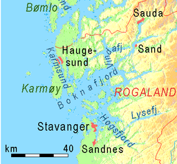
250:. There are dozens of smaller fjords that branch off the main part of the fjord, reaching most municipalities in the county. At its longest, the Boknafjord reaches about 96 kilometres (60 mi) into the mainland at the innermost point of the
353:
to the mainland by road. The 24-kilometre (15 mi) long and 350-metre (1,150 ft) deep tunnel is projected to be completed in 2029. Construction began in 2018. It will be the longest and deepest underwater road
297:
The vast fjord is quite wide, and it has many islands located within its shores, some of which are quite large. Some of the notable islands include
69:
349:
and ultimately becoming part of a ferry-free highway system along the western coast of Norway. It will also connect the island municipality of
470:
113:
493:
341:
is a huge tunnel project that will construct a tunnel under the
Boknafjord and the Kvitsøyfjord connecting the cities of
508:
389:
230:
and dominates the central part of the county. The main part of the fjord is shared between the municipalities of
441:
145:
318:
306:
302:
271:
267:
513:
528:
523:
314:
346:
342:
227:
223:
191:
322:
279:
283:
159:
518:
502:
291:
263:
259:
255:
56:
17:
298:
287:
251:
44:
466:
350:
231:
128:
115:
275:
235:
152:
247:
239:
215:
98:
334:
146:
355:
338:
219:
165:
211:
367:
360:
310:
243:
445:
397:(PDF). Oslo: Norwegian Seafood Federation. 2013. p. 70.
425:
Ecology of
Coastal Waters: With Implications for Management
187:
183:
175:
171:
158:
144:
105:
94:
32:
106:
427:. Malden, MA: Blackwell Science. p. 114.
222:. The huge fjord lies between the cities of
8:
358:in the world. The cost was expected to be
29:
381:
254:. Other notable branches include the
436:
434:
7:
76:
412:. Boston: Brooks/Cole. p. 122.
25:
75:
68:
55:
43:
27:Fjord in Rogaland county, Norway
174:
282:, Årdalsfjorden, Idsefjorden,
1:
93:
545:
363:500–600 million
179:96 kilometres (60 mi)
423:Mann, Kenneth H. (2009).
207:
63:
54:
42:
37:
410:World Regional Geography
49:Aerial view of the fjord
408:Hobbs, Joseph (2008).
365:, but later raised to
442:Store norske leksikon
391:Environmental Report
125: /
509:Fjords of Rogaland
129:59.1193°N 5.4061°E
370:1700 million
197:
196:
18:Nedstrandsfjorden
16:(Redirected from
536:
481:
480:
478:
477:
469:(in Norwegian).
463:
457:
456:
454:
453:
438:
429:
428:
420:
414:
413:
405:
399:
398:
396:
386:
371:
364:
209:
148:
147:Primary outflows
140:
139:
137:
136:
135:
130:
126:
123:
122:
121:
118:
108:
79:
78:
72:
59:
47:
30:
21:
544:
543:
539:
538:
537:
535:
534:
533:
499:
498:
490:
485:
484:
475:
473:
465:
464:
460:
451:
449:
440:
439:
432:
422:
421:
417:
407:
406:
402:
394:
388:
387:
383:
378:
366:
359:
331:
162: countries
134:59.1193; 5.4061
133:
131:
127:
124:
119:
116:
114:
112:
111:
90:
89:
88:
87:
86:
85:
84:
80:
50:
28:
23:
22:
15:
12:
11:
5:
542:
540:
532:
531:
526:
521:
516:
511:
501:
500:
497:
496:
489:
488:External links
486:
483:
482:
458:
448:(in Norwegian)
446:"Boknafjorden"
430:
415:
400:
380:
379:
377:
374:
330:
327:
195:
194:
189:
185:
184:
181:
180:
177:
173:
172:
169:
168:
163:
156:
155:
150:
142:
141:
109:
103:
102:
101:county, Norway
96:
92:
91:
82:
81:
74:
73:
67:
66:
65:
64:
61:
60:
52:
51:
48:
40:
39:
35:
34:
26:
24:
14:
13:
10:
9:
6:
4:
3:
2:
541:
530:
527:
525:
522:
520:
517:
515:
512:
510:
507:
506:
504:
495:
492:
491:
487:
472:
468:
467:"E39 Rogfast"
462:
459:
447:
443:
437:
435:
431:
426:
419:
416:
411:
404:
401:
393:
392:
385:
382:
375:
373:
369:
362:
357:
352:
348:
344:
340:
336:
328:
326:
325:archipelago.
324:
320:
316:
312:
308:
304:
300:
295:
293:
289:
285:
281:
277:
273:
272:Førresfjorden
269:
268:Hervikfjorden
265:
261:
257:
253:
249:
245:
241:
237:
233:
229:
225:
221:
217:
213:
205:
201:
193:
190:
186:
182:
178:
170:
167:
164:
161:
157:
154:
151:
149:
143:
138:
110:
104:
100:
97:
71:
62:
58:
53:
46:
41:
36:
31:
19:
474:. Retrieved
461:
450:. Retrieved
424:
418:
409:
403:
390:
384:
332:
323:Sjernarøyane
296:
292:Gandsfjorden
280:Jøsenfjorden
264:Vindafjorden
260:Sandsfjorden
256:Saudafjorden
204:Boknafjorden
203:
199:
198:
83:Boknafjorden
33:Boknafjorden
494:E39 Rogfast
471:Vegvesen.no
299:Vestre Bokn
288:Lysefjorden
284:Høgsfjorden
252:Hylsfjorden
214:located in
208:Bokna Fjord
188:Settlements
176:Max. length
132: /
107:Coordinates
503:Categories
476:2013-02-06
452:2015-08-27
376:References
321:, and the
206:(English:
200:Boknafjord
117:59°07′09″N
38:Boknafjord
514:Stavanger
347:Haugesund
343:Stavanger
276:Erfjorden
236:Stavanger
228:Haugesund
224:Stavanger
192:Stavanger
153:North Sea
120:5°24′22″E
337:sub-sea
319:Mosterøy
307:Rennesøy
218:county,
216:Rogaland
99:Rogaland
95:Location
351:Kvitsøy
335:Rogfast
303:Kvitsøy
232:Kvitsøy
210:) is a
529:Tysvær
524:Karmøy
356:tunnel
339:tunnel
329:Tunnel
315:Finnøy
290:, and
248:Karmøy
246:, and
240:Tysvær
220:Norway
166:Norway
395:(PDF)
212:fjord
160:Basin
519:Bokn
345:and
333:The
311:Ombo
244:Bokn
226:and
202:or
505::
444:.
433:^
372:.
317:,
313:,
309:,
305:,
301:,
294:.
286:,
278:,
274:,
270:,
266:,
262:,
258:,
242:,
238:,
234:,
479:.
455:.
368:€
361:€
20:)
Text is available under the Creative Commons Attribution-ShareAlike License. Additional terms may apply.