135:
29:
128:
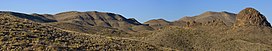
200:, a circular domal uplift with a nine-mile diameter and a prominent limestone rim. The area is desert mountain terrain of basalt deposits. The vegetation consists primarily of sparse grasses, cacti, desert shrubs, and scrub brush. Needle Peak was named for its configuration.
192:, United States. Its summit, at an elevation of 4,608 feet (1,405 m) above sea level, rises 328 ft (100 m) over the Lower Shutup, a canyon that runs along its eastern edge. Needle Peak is a
207:, the small Sierra Aguja range, which is about 17 miles southeast of Needle Peak in Presidio County. The slopes of this range are noted as a source of quartz crystals, including green
84:
670:
386:
498:
271:
599:
204:
262:
614:
379:
395:
267:
127:
343:
77:
665:
554:
372:
318:
534:
426:
644:
579:
574:
257:
544:
434:
185:
147:
64:
54:
452:
609:
539:
480:
444:
619:
594:
584:
569:
457:
639:
624:
549:
559:
416:
403:
296:
564:
529:
472:
167:
235:
514:
462:
659:
629:
519:
155:
634:
490:
28:
203:
Locally, the name Needle Peak is also used to refer to another nearby location,
589:
524:
411:
347:
212:
208:
99:
86:
197:
70:
322:
193:
364:
44:
215:
189:
151:
172:
368:
507:
489:
471:
443:
425:
402:
290:
288:
166:
115:
76:
63:
53:
43:
38:
21:
380:
8:
218:, Needle Peak sagenite, and pompon agates.
387:
373:
365:
18:
272:United States Department of the Interior
227:
7:
299:. Texas State Historical Association
205:Needle Peak (Brewster County, Texas)
671:Landforms of Presidio County, Texas
263:Geographic Names Information System
134:
14:
196:intrusion and stands within the
133:
126:
27:
16:Mountain in Texas, United States
268:United States Geological Survey
1:
605:Needle Peak (Presidio County)
600:Needle Peak (Brewster County)
49:4,608 ft (1,405 m)
687:
100:29.4282479°N 103.8101914°W
120:
26:
344:"Agates with Inclusions"
105:29.4282479; -103.8101914
59:821 ft (250 m)
33:Needle Peak at far right
435:North Franklin Mountain
319:"Needle Peak Geology"
610:Palo Pinto Mountains
295:Julia Cauble Smith.
555:Christmas Mountains
499:Packsaddle Mountain
481:Cerro Alto Mountain
445:Guadalupe Mountains
317:Tommy R. Woodward.
96: /
666:Mountains of Texas
620:Round Top Mountain
595:Las Moras Mountain
585:Greenwood Mountain
570:Delaware Mountains
535:Carpenter Mountain
427:Franklin Mountains
396:Mountains of Texas
39:Highest point
653:
652:
640:Slipdown Mountain
625:Sierra del Carmen
615:Rattlesnake Point
550:Chinati Mountains
179:
178:
678:
645:Tackett Mountain
580:Granite Mountain
575:Double Mountains
560:Cusseta Mountain
417:Casa Grande Peak
404:Chisos Mountains
389:
382:
375:
366:
359:
358:
356:
355:
346:. Archived from
340:
334:
333:
331:
330:
321:. Archived from
314:
308:
307:
305:
304:
292:
283:
282:
280:
278:
254:
248:
247:
245:
243:
232:
137:
136:
130:
111:
110:
108:
107:
106:
101:
97:
94:
93:
92:
89:
31:
19:
686:
685:
681:
680:
679:
677:
676:
675:
656:
655:
654:
649:
565:Davis Mountains
545:Chalk Mountains
530:Beach Mountains
503:
485:
473:Hueco Mountains
467:
439:
421:
398:
393:
363:
362:
353:
351:
342:
341:
337:
328:
326:
316:
315:
311:
302:
300:
294:
293:
286:
276:
274:
256:
255:
251:
241:
239:
234:
233:
229:
224:
188:, in southwest
186:Presidio County
162:
161:
160:
159:
158:
148:Presidio County
145:
144:
143:
142:
138:
104:
102:
98:
95:
90:
87:
85:
83:
82:
34:
17:
12:
11:
5:
684:
682:
674:
673:
668:
658:
657:
651:
650:
648:
647:
642:
637:
632:
627:
622:
617:
612:
607:
602:
597:
592:
587:
582:
577:
572:
567:
562:
557:
552:
547:
542:
537:
532:
527:
522:
517:
515:Enchanted Rock
511:
509:
505:
504:
502:
501:
495:
493:
487:
486:
484:
483:
477:
475:
469:
468:
466:
465:
463:Guadalupe Peak
460:
455:
449:
447:
441:
440:
438:
437:
431:
429:
423:
422:
420:
419:
414:
408:
406:
400:
399:
394:
392:
391:
384:
377:
369:
361:
360:
335:
309:
284:
249:
238:. List of John
226:
225:
223:
220:
184:is located in
177:
176:
170:
164:
163:
146:
140:
139:
132:
131:
125:
124:
123:
122:
121:
118:
117:
113:
112:
80:
74:
73:
67:
61:
60:
57:
51:
50:
47:
41:
40:
36:
35:
32:
24:
23:
15:
13:
10:
9:
6:
4:
3:
2:
683:
672:
669:
667:
664:
663:
661:
646:
643:
641:
638:
636:
633:
631:
630:Sierra Diablo
628:
626:
623:
621:
618:
616:
613:
611:
608:
606:
603:
601:
598:
596:
593:
591:
588:
586:
583:
581:
578:
576:
573:
571:
568:
566:
563:
561:
558:
556:
553:
551:
548:
546:
543:
541:
538:
536:
533:
531:
528:
526:
523:
521:
520:Bachelor Peak
518:
516:
513:
512:
510:
506:
500:
497:
496:
494:
492:
488:
482:
479:
478:
476:
474:
470:
464:
461:
459:
456:
454:
453:Bush Mountain
451:
450:
448:
446:
442:
436:
433:
432:
430:
428:
424:
418:
415:
413:
410:
409:
407:
405:
401:
397:
390:
385:
383:
378:
376:
371:
370:
367:
350:on 2008-05-16
349:
345:
339:
336:
325:on 2016-03-03
324:
320:
313:
310:
298:
291:
289:
285:
273:
269:
265:
264:
259:
258:"Needle Peak"
253:
250:
237:
236:"Needle Peak"
231:
228:
221:
219:
217:
214:
210:
206:
201:
199:
195:
191:
187:
183:
175:The Solitario
174:
171:
169:
165:
157:
153:
149:
129:
119:
114:
109:
81:
79:
75:
72:
68:
66:
62:
58:
56:
52:
48:
46:
42:
37:
30:
25:
20:
635:Sierra Vieja
604:
491:Llano Uplift
352:. Retrieved
348:the original
338:
327:. Retrieved
323:the original
312:
301:. Retrieved
275:. Retrieved
261:
252:
240:. Retrieved
230:
202:
181:
180:
540:Castle Peak
297:"Solitario"
182:Needle Peak
141:Needle Peak
103: /
91:103°48′37″W
78:Coordinates
65:Parent peak
22:Needle Peak
660:Categories
590:Hairy Knob
525:Bare Butte
458:El Capitan
412:Emory Peak
354:2008-04-08
329:2008-04-08
303:2008-04-08
277:January 5,
242:January 5,
222:References
213:botryoidal
209:moss agate
88:29°25′42″N
55:Prominence
198:Solitario
116:Geography
71:Solitario
45:Elevation
194:Tertiary
168:Topo map
508:Others
216:geodes
190:Texas
152:Texas
279:2013
244:2013
173:USGS
156:U.S.
69:The
662::
287:^
270:,
266:.
260:.
211:,
154:,
150:,
388:e
381:t
374:v
357:.
332:.
306:.
281:.
246:.
Text is available under the Creative Commons Attribution-ShareAlike License. Additional terms may apply.