177:
31:
184:
532:
399:
was about 0.5 mile (1 km) north of the town center, just north of
Cambridge Avenue and west of East Elm Avenue. It opened sometime in the 1920s. As of 2024 traces of it could still be seen on aerial photographs and satellite images. The New Coalinga Municipal Airport was built in the late 1990s
569:
588:
134:
562:
593:
176:
555:
396:
370:
349:
67:
127:
30:
385:
487:
452:
117:
381:
109:
448:
373:
70:
499:
416:) and has two runways (1/19: 2,500 x 60 ft (18 m), 12/30: 5,000 x 100 ft) and one
362:
56:
45:
539:
424:
247:
582:
515:
505:
465:
423:
In the year ending May 9, 2003 the airport had 2,400 aircraft operations, all
389:
149:
136:
531:
509:
400:
east of the town center, with an entrance road from West Phelps Avenue.
417:
413:
276:
251:
217:
204:
493:
409:
543:
468:
Lemoore
Emergency Landing Field. Retrieved 2012-01-17.
392:, United States. It is owned by the city of Coalinga.
334:
325:
275:
203:
165:
126:
115:
105:
97:
89:
84:
21:
563:
538:This article about a California airport is a
466:http://www.militarymuseum.org/LemooreELF.html
8:
570:
556:
331:
18:
436:
589:Airports in Fresno County, California
444:
442:
440:
7:
528:
526:
542:. You can help Knowledge (XXG) by
14:
530:
182:
175:
29:
350:Federal Aviation Administration
96:
16:Airport in Coalinga, California
359:New Coalinga Municipal Airport
23:New Coalinga Municipal Airport
1:
449:FAA Airport Form 5010 for C80
483:Resources for this airport:
494:airport information for C80
488:airport information for C80
183:
610:
525:
516:aeronautical chart for C80
397:Coalinga Municipal Airport
408:The airport covers 1,002
380:) is three miles east of
346:
330:
294:
291:
288:
284:
224:
221:
216:
212:
170:
40:
28:
594:California airport stubs
500:accident history for CLG
122:622 ft / 190 m
420:(H1: 50 x 50 ft).
456:, effective 2007-07-05
150:36.16306°N 120.29389°W
155:36.16306; -120.29389
110:Coalinga, California
510:live flight tracker
506:airport information
335:Aircraft operations
146: /
551:
550:
455:
356:
355:
342:
341:
326:Statistics (2003)
321:
320:
271:
270:
601:
572:
565:
558:
534:
527:
469:
463:
457:
451:
446:
425:general aviation
332:
286:
285:
279:
214:
213:
207:
186:
185:
179:
161:
160:
158:
157:
156:
151:
147:
144:
143:
142:
139:
101:City of Coalinga
77:
76:
63:
62:
52:
51:
33:
19:
609:
608:
604:
603:
602:
600:
599:
598:
579:
578:
577:
576:
523:
478:
473:
472:
464:
460:
447:
438:
433:
406:
352:
277:
205:
199:
198:
197:
196:
195:
194:
193:
187:
154:
152:
148:
145:
140:
137:
135:
133:
132:
116:Elevation
80:
74:
66:
60:
55:
49:
44:
36:
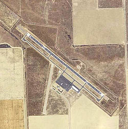
35:2006 USGS photo
24:
17:
12:
11:
5:
607:
605:
597:
596:
591:
581:
580:
575:
574:
567:
560:
552:
549:
548:
535:
521:
520:
519:
518:
512:
502:
496:
490:
481:
477:
476:External links
474:
471:
470:
458:
435:
434:
432:
429:
405:
402:
354:
353:
347:
344:
343:
340:
339:
336:
328:
327:
323:
322:
319:
318:
315:
312:
309:
305:
304:
301:
297:
296:
293:
290:
282:
281:
273:
272:
269:
268:
265:
262:
259:
255:
254:
245:
242:
239:
235:
234:
231:
227:
226:
223:
220:
210:
209:
201:
200:
189:
188:
181:
180:
174:
173:
172:
171:
168:
167:
163:
162:
130:
124:
123:
120:
113:
112:
107:
103:
102:
99:
95:
94:
91:
87:
86:
82:
81:
79:
78:
64:
53:
41:
38:
37:
34:
26:
25:
22:
15:
13:
10:
9:
6:
4:
3:
2:
606:
595:
592:
590:
587:
586:
584:
573:
568:
566:
561:
559:
554:
553:
547:
545:
541:
536:
533:
529:
524:
517:
513:
511:
507:
503:
501:
497:
495:
491:
489:
485:
484:
482:
480:
479:
475:
467:
462:
459:
454:
450:
445:
443:
441:
437:
430:
428:
426:
421:
419:
415:
411:
403:
401:
398:
395:The original
393:
391:
387:
386:Fresno County
383:
379:
375:
372:
368:
364:
360:
351:
345:
337:
333:
329:
324:
316:
313:
310:
307:
306:
302:
299:
298:
287:
283:
280:
274:
266:
263:
260:
257:
256:
253:
249:
246:
243:
240:
237:
236:
232:
229:
228:
219:
215:
211:
208:
202:
192:
178:
169:
164:
159:
131:
129:
125:
121:
119:
114:
111:
108:
104:
100:
92:
88:
83:
72:
69:
65:
58:
54:
47:
43:
42:
39:
32:
27:
20:
544:expanding it
537:
522:
504:FlightAware
461:
422:
407:
394:
377:
366:
358:
357:
190:
90:Airport type
153: /
141:120°17′38″W
128:Coordinates
583:Categories
514:SkyVector
431:References
412:(405
404:Facilities
390:California
138:36°09′47″N
218:Direction
382:Coalinga
348:Source:
317:Asphalt
295:Surface
278:Helipads
267:Asphalt
225:Surface
106:Location
492:AirNav
418:helipad
292:Length
289:Number
248:Asphalt
222:Length
206:Runways
85:Summary
264:1,524
261:5,000
258:12/30
252:gravel
241:2,500
93:Public
410:acres
384:, in
338:2,400
238:1/19
98:Owner
540:stub
508:and
498:ASN
486:FAA
363:IATA
244:762
118:AMSL
61:none
57:ICAO
46:IATA
453:PDF
378:C80
374:LID
371:FAA
367:CLG
314:15
311:50
308:H1
300:ft
230:ft
191:C80
166:Map
75:C80
71:LID
68:FAA
50:CLG
585::
439:^
427:.
414:ha
388:,
376::
369:,
365::
303:m
233:m
73::
59::
48::
571:e
564:t
557:v
546:.
361:(
250:/
Text is available under the Creative Commons Attribution-ShareAlike License. Additional terms may apply.