222:
193:
163:
38:
200:
170:
344:, forming a junction with the Tamar at Morwellham quay, completed in June 1817 with a tunnel of 1.75 miles (2.82 km) altogether built at an expense of £68,000 (equivalent to £6,289,000 in 2023) being in engineering and in export of ores a remarkable achievement before its decline in the 1860s.
351:
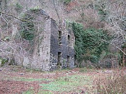
Since the village was abandoned in the early 20th century it became overgrown and large cut masonry stones from the quay were stolen. In 2008 work was begun to halt New Quay's further destruction: many of the buildings were stabilised and repaired and much of the undergrowth was cut back.
347:
An account of the county in 1818 states "the Tamar is navigable to New Quay...for vessels of about 130 or 140 tons: vessels of fourteen feet draught go up to
Morwell-ham quay, six miles from Plymouth" — the first distance appears to be an error.
597:
192:
360:
Trains on the mine tramway from
Morwellham stop at new Quay with local guides to show structures and explain the mining and cultural activities of the valley.
298:
Closest mines are the Gawton
Arsenic Mine, a scheduled ancient monument, Bedford Consolidated Mine and the George and Charlotte Mine. Across the water was
221:
577:
287:
77:
333:. The mining families in the community were split between the established church and other sects of Protestantism - the then small town of
162:
587:
124:
436:
404:
431:
399:
48:
117:
266:
520:
Tavistock in A Topographical
Dictionary of England, ed. Samuel Lewis (London, 1848), p. 307. Accessed 30 March 2015.
511:
Daniel and Samuel Lysons, in Magna
Britannia: Volume 6, Devonshire (London, 1822), pp. 27-47 Accessed 31 March 2015.
582:
27:
318:
109:
337:
to the south having had chapels or meeting houses for these in 1887 including a
Presbyterian Church in 1822.
307:
460:
273:
313:
As with
Morwellham, the whole area is in the south of the highly scattered late 19th century parish of
592:
529:
363:
The site can be visited without guides on foot and further public access is planned for the future.
303:
85:
37:
508:
553:
326:
233:
427:
395:
330:
472:
341:
245:
283:
65:
571:
499:
Vision of
Britain (The University of Portsmouth and Others). Accessed 2015-03-31
487:
Vision of
Britain (The University of Portsmouth and Others). Accessed 2015-03-31
334:
244:. New Quay village is immediately east of and downstream of the similar port of
237:
463:
Daniel and Samuel Lysons, (London, 1822), pp. 176-198. Accessed 31 March 2015.
57:
139:
126:
496:
484:
314:
53:
340:
It to an extent benefited from the short but major engineering feat of the
98:
322:
257:
380:
261:
249:
545:
306:
Mine, East and West
Liscombe and Wheal Tamar Copper Mines, and the
241:
220:
61:
248:(now the heart of an open-air museum). New Quay was an important
497:
Beer Alston extract from John Marius Wilson's Gazetteer of 1887
253:
321:
and a small contributor parish to an ecclesiastical
461:'Produce', in Magna Britannia: Volume 6, Devonshire
116:
104:
94:
84:
71:
47:
26:
432:"Details from listed building database (1172206)"
400:"Details from listed building database (1002667)"
509:'Parishes: Bere Ferrers including Bere Alston'
8:
225:Entrance to George and Charlotte copper mine
21:
554:"Tamar Valley AONB project group's website"
475:The Church of England. Accessed 2015-03-31
381:"Cornwall and West Devon Mining Landscape"
282:. Since July 2006 New Quay is within the
234:abandoned hamlet and intensive mining port
36:
20:
598:Industrial archaeological sites in Devon
456:
454:
288:Cornwall and West Devon Mining Landscape
199:
169:
78:Cornwall and West Devon Mining Landscape
372:
302:. On the eastern high ridge were Tavy
75:"Tamar Valley Mining District" part of
16:Abandoned port hamlet in Devon, England
207:New Quay (Devon) (the United Kingdom)
103:
93:
83:
70:
46:
7:
236:on the steep, winding banks of the
437:National Heritage List for England
405:National Heritage List for England
14:
578:Former populated places in Devon
198:
191:
168:
161:
210:Show map of the United Kingdom
42:Abandoned building at New Quay
1:
178:Location of New Quay in Devon
90:Cultural: (ii)(iii)(iv)
588:Ports and harbours of Devon
232:is a small once industrial
614:
425:George and Charlotte Mine
300:Harewood Consolidated Mine
29:UNESCO World Heritage Site
546:"Morwellham Quay website"
329:, previously a hamlet of
155:
35:
260:port serving the local
226:
530:BBC Inside Out series
224:
393:Gawton arsenic mine
473:Parish of Gulworthy
280:Gawton Arsenic Mine
136: /
23:
269:and Charlotte Mine
227:
583:Villages in Devon
327:Church of England
286:Site that is the
276:Consolidated Mine
219:
218:
182:Show map of Devon
605:
564:
562:
560:
549:
532:
527:
521:
518:
512:
506:
500:
494:
488:
485:Gulworthy, Devon
482:
476:
470:
464:
458:
449:
448:
446:
444:
428:Historic England
423:
417:
416:
414:
412:
396:Historic England
391:
385:
384:
377:
308:William and Mary
211:
202:
201:
195:
183:
172:
171:
165:
151:
150:
148:
147:
146:
141:
140:50.505°N 4.181°W
137:
134:
133:
132:
129:
40:
30:
24:
613:
612:
608:
607:
606:
604:
603:
602:
568:
567:
558:
556:
552:
544:
541:
536:
535:
528:
524:
519:
515:
507:
503:
495:
491:
483:
479:
471:
467:
459:
452:
442:
440:
426:
424:
420:
410:
408:
394:
392:
388:
379:
378:
374:
369:
358:
342:Tavistock Canal
296:
246:Morwellham Quay
215:
214:
213:
212:
209:
208:
205:
204:
203:
186:
185:
184:
181:
180:
179:
175:
174:
173:
144:
142:
138:
135:
130:
127:
125:
123:
122:
43:
28:
17:
12:
11:
5:
611:
609:
601:
600:
595:
590:
585:
580:
570:
569:
566:
565:
550:
540:
539:External links
537:
534:
533:
522:
513:
501:
489:
477:
465:
450:
418:
386:
371:
370:
368:
365:
357:
354:
295:
292:
284:World Heritage
264:including the
217:
216:
206:
197:
196:
190:
189:
188:
187:
177:
176:
167:
166:
160:
159:
158:
157:
156:
153:
152:
145:50.505; -4.181
120:
114:
113:
106:
102:
101:
96:
92:
91:
88:
82:
81:
73:
69:
68:
66:United Kingdom
51:
45:
44:
41:
33:
32:
15:
13:
10:
9:
6:
4:
3:
2:
610:
599:
596:
594:
591:
589:
586:
584:
581:
579:
576:
575:
573:
555:
551:
547:
543:
542:
538:
531:
526:
523:
517:
514:
510:
505:
502:
498:
493:
490:
486:
481:
478:
474:
469:
466:
462:
457:
455:
451:
439:
438:
433:
429:
422:
419:
407:
406:
401:
397:
390:
387:
382:
376:
373:
366:
364:
361:
355:
353:
349:
345:
343:
338:
336:
332:
328:
324:
320:
316:
311:
309:
305:
301:
293:
291:
289:
285:
281:
277:
275:
270:
268:
263:
259:
255:
251:
247:
243:
239:
235:
231:
223:
194:
164:
154:
149:
121:
119:
115:
111:
107:
100:
97:
89:
87:
80:
79:
74:
67:
63:
59:
55:
52:
50:
39:
34:
31:
25:
19:
557:. Retrieved
525:
516:
504:
492:
480:
468:
441:. Retrieved
435:
421:
409:. Retrieved
403:
389:
375:
362:
359:
350:
346:
339:
319:civil parish
312:
304:Consolidated
299:
297:
279:
272:
265:
229:
228:
76:
18:
593:River Tamar
335:Bere Alston
238:River Tamar
143: /
118:Coordinates
108:2006 (30th
105:Inscription
572:Categories
367:References
317:, today a
256:and later
128:50°30′18″N
58:West Devon
331:Tavistock
315:Gulworthy
131:4°10′52″W
99:1215-010i
95:Reference
54:Gulworthy
559:11 April
443:31 March
411:31 March
323:benefice
230:New Quay
86:Criteria
49:Location
22:New Quay
325:in the
294:History
274:Bedford
258:arsenic
110:Session
72:Part of
310:Mine.
267:George
250:copper
356:Today
262:mines
242:Devon
62:Devon
561:2009
445:2015
413:2015
278:and
254:tin
240:in
574::
453:^
434:.
430:.
402:.
398:.
290:.
271:,
252:,
64:,
60:,
56:,
563:.
548:.
447:.
415:.
383:.
112:)
Text is available under the Creative Commons Attribution-ShareAlike License. Additional terms may apply.