29:
486:
454:
525:
251:
28:
530:
281:, while the section in Radnorshire became New Radnor Rural District. The new district took its name from the village of
466:
384:
266:
462:
349:
344:
388:
294:
278:
200:
163:
194:
387:, which completely reorganised local administration in England and Wales. Its area became part of the
535:
308:
439:
426:
339:
377:
270:
131:
434:
421:
359:
313:
247:
177:
519:
274:
301:
231:
297:
in
Herefordshire until the last few years when it was transferred to Presteigne.
290:
255:
364:
354:
282:
204:
501:
488:
323:
318:
370:
328:
286:
392:
259:
411:
Census of
England and Wales 1901, County Report, Radnorshire
225:
218:
191:
183:
173:
157:
147:
137:
125:
118:
104:
94:
84:
77:
63:
53:
43:
36:
21:
383:The district was abolished in 1974 under the
8:
455:"Relationships / unit history of New Radnor"
18:
293:of Radnorshire. The council was based in
404:
217:
182:
172:
117:
76:
35:
300:The rural district comprised fifteen
273:was divided into two: the section in
224:
213:
190:
156:
146:
136:
124:
103:
93:
83:
62:
52:
42:
7:
16:Rural district in Radnorshire, Wales
14:
187:New Radnor Rural District Council
27:
265:The district was formed by the
336:Kinnerton, Salford and Badland
159: • Succeeded by
1:
430:. 30 July 1965. p. 7284.
69:51,893 acres (210.00 km)
59:51,893 acres (210.00 km)
49:51,893 acres (210.00 km)
443:. 21 May 1968. p. 5775.
269:, when the existing Kington
552:
246:was, from 1894 to 1974, a
385:Local Government Act 1972
267:Local Government Act 1894
237:
214:
210:
169:
114:
73:
26:
526:Rural districts of Wales
463:University of Portsmouth
345:Llanfihangel Nant Melan
271:Rural Sanitary District
531:History of Radnorshire
350:Michaelchurch on Arrow
279:Kington Rural District
149: • Abolished
391:in the new county of
277:was reconstituted as
252:administrative county
333:Harpton and Wolfpits
139: • Created
498: /
127: • Origin
440:The London Gazette
427:The London Gazette
389:District of Radnor
459:Vision of Britain
241:
240:
227: • Type
132:Sanitary district
106: • 1971
96: • 1931
86: • 1901
65: • 1961
55: • 1931
45: • 1911
543:
513:
512:
510:
509:
508:
503:
502:52.196°N 3.144°W
499:
496:
495:
494:
491:
478:
477:
475:
474:
465:. Archived from
451:
445:
444:
431:
418:
412:
409:
285:, at one time a
228:
197:
160:
150:
140:
128:
107:
97:
87:
66:
56:
46:
31:
19:
551:
550:
546:
545:
544:
542:
541:
540:
516:
515:
506:
504:
500:
497:
492:
489:
487:
485:
484:
482:
481:
472:
470:
453:
452:
448:
433:
420:
419:
415:
410:
406:
401:
367:and Burlingjobb
226:
192:
158:
148:
138:
126:
105:
95:
85:
64:
54:
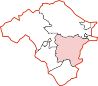
44:
32:
17:
12:
11:
5:
549:
547:
539:
538:
533:
528:
518:
517:
507:52.196; -3.144
480:
479:
446:
413:
403:
402:
400:
397:
381:
380:
374:
368:
362:
357:
352:
347:
342:
337:
334:
331:
326:
321:
316:
311:
302:civil parishes
248:rural district
239:
238:
235:
234:
232:Civil parishes
229:
223:
222:
220:
216:
215:
212:
211:
208:
207:
198:
189:
188:
185:
181:
180:
178:Rural district
175:
171:
170:
167:
166:
161:
155:
154:
151:
145:
144:
141:
135:
134:
129:
123:
122:
120:
116:
115:
112:
111:
108:
102:
101:
98:
92:
91:
88:
82:
81:
79:
75:
74:
71:
70:
67:
61:
60:
57:
51:
50:
47:
41:
40:
38:
34:
33:
24:
23:
15:
13:
10:
9:
6:
4:
3:
2:
548:
537:
534:
532:
529:
527:
524:
523:
521:
514:
511:
469:on 2011-06-04
468:
464:
460:
456:
450:
447:
442:
441:
436:
429:
428:
423:
417:
414:
408:
405:
398:
396:
394:
390:
386:
379:
375:
372:
369:
366:
363:
361:
358:
356:
353:
351:
348:
346:
343:
341:
338:
335:
332:
330:
327:
325:
322:
320:
317:
315:
312:
310:
307:
306:
305:
303:
298:
296:
292:
288:
284:
280:
276:
275:Herefordshire
272:
268:
263:
261:
257:
253:
249:
245:
236:
233:
230:
221:
209:
206:
202:
199:
196:
193: •
186:
179:
176:
168:
165:
162:
152:
142:
133:
130:
121:
113:
109:
99:
89:
80:
72:
68:
58:
48:
39:
30:
25:
20:
483:
471:. Retrieved
467:the original
458:
449:
438:
425:
416:
407:
382:
373:and Gwailtha
299:
264:
243:
242:
219:Subdivisions
536:Radnorshire
505: /
435:"No. 44591"
422:"No. 43725"
376:Walton and
291:county town
256:Radnorshire
164:Radnorshire
520:Categories
490:52°11′46″N
473:2009-02-10
399:References
365:Old Radnor
355:New Radnor
340:Llandeglau
283:New Radnor
244:New Radnor
205:Presteigne
184:Government
78:Population
22:New Radnor
493:3°08′38″W
360:Newchurch
324:Gladestry
203:and then
378:Womaston
319:Evenjobb
371:Trewern
329:Glascwm
295:Kington
287:borough
250:in the
201:Kington
119:History
174:Status
393:Powys
314:Ednol
309:Colva
260:Wales
110:1,753
100:2,581
90:2,944
289:and
153:1974
143:1894
37:Area
304::
254:of
522::
461:.
457:.
437:.
432:,
424:.
395:.
262:.
258:,
195:HQ
476:.
Text is available under the Creative Commons Attribution-ShareAlike License. Additional terms may apply.