250:
29:
793:
1264:
436:
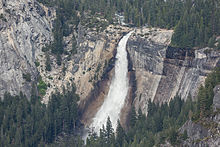
190:. The waterfall is widely recognized by its "bent" shape, in which the water free-falls for roughly the first third of its length to a steep slick-rock slope. This mid-fall impact of the water on the cliff face creates a turbulent, whitewater appearance in the fall and produces a great deal of mist which covers a wide radius, which led to its current name (
260:
In spite of the dangers and deaths as recently as June 2013, the pool above Nevada Fall remains a popular swimming location, with no park restrictions. In June 2018, an 18-year-old teenager fell to his death from the edge of the fall while attempting to take a
236:
The hike to the top of Nevada Fall, along the Mist Trail, is 3 miles (4.8 km) from the trailhead in
Yosemite Valley. One must first hike to Vernal Fall and then trek another 2 miles (3.2 km) to reach the top. The
205:
suggested the name "Nevada" for the waterfall. He wrote, "The Nevada Fall was so called because it was the nearest to the Sierra Nevada, and because the name was sufficiently indicative of a wintry companion for our spring
217:
forms on the "step" between Nevada Fall and Vernal Fall downstream. The 317-foot (97 m) high Vernal Fall is a short hike from the bottom of Nevada Fall. They form a cascade in which the Merced River flows down to
1228:
301:
1334:
599:
1324:
1233:
1118:
468:
76:
848:
1305:
1344:
1101:
592:
249:
889:
310:
210:)... The white, foaming water, as it dashed down Yo-wy-we from the snowy mountains, represented to my mind a vast avalanche of snow."
461:
1238:
585:
1067:
1339:
803:
616:
1223:
1218:
629:
385:
69:
1298:
1041:
454:
54:
1133:
1123:
912:
882:
1161:
1128:
1106:
1026:
501:
28:
1111:
940:
742:
723:
352:
183:
334:
1072:
1062:
440:
1291:
1200:
1165:
933:
782:
767:
762:
608:
187:
171:
50:
1329:
1185:
1156:
1016:
947:
309:(Map) (Shaded Relief ed.). 1:24,000. Reston, Virginia: U.S. Department of Interior. Archived from
1195:
1190:
1180:
1175:
903:
644:
282:
1151:
792:
541:
1170:
998:
919:
531:
364:
347:
1263:
1243:
1046:
1036:
777:
705:
556:
202:
1275:
407:
896:
669:
654:
546:
506:
195:
988:
983:
813:
732:
679:
624:
551:
521:
496:
483:
238:
219:
46:
926:
1021:
973:
853:
833:
823:
772:
694:
649:
566:
511:
1318:
1082:
843:
828:
712:
639:
536:
254:
230:
62:
1031:
993:
863:
858:
634:
214:
201:
The Indian name was Yo-wy-we, signifying the twist or squirm of the falling water.
179:
167:
408:"Teen falls to his death in Yosemite National Park after trying to take a selfie"
978:
752:
737:
664:
561:
526:
446:
207:
838:
818:
747:
699:
659:
477:
241:, which starts near the trail to Happy Isles, goes to the top of Nevada Fall.
175:
58:
91:
78:
968:
718:
689:
163:
108:
435:
1271:
1077:
577:
335:
U.S. Geological Survey
Geographic Names Information System: Nevada Fall
262:
248:
303:
Yosemite
National Park and Wilderness, California Mariposa County
581:
450:
1229:
National
Register of Historic Places in Yosemite National Park
791:
1279:
1209:
1142:
1091:
1055:
1007:
961:
872:
802:
678:
615:
386:"Hope fades for teen swept over Yosemite waterfall"
149:
141:
133:
125:
117:
107:
68:
42:
21:
229:, which is evident when viewed from above, at
1299:
593:
462:
8:
1306:
1292:
675:
600:
586:
578:
469:
455:
447:
27:
18:
1335:Waterfalls of Mariposa County, California
300:United States Geological Survey (1958).
333:The official spelling is singular, see
274:
225:This cascade is sometimes called the
7:
1325:Waterfalls of Yosemite National Park
1260:
1258:
365:"Vernal Fall and Nevada Fall Trails"
934:Steck-Salathé Route (Sentinel Rock)
1278:. You can help Knowledge (XXG) by
1157:El Portal & Arch Rock Entrance
406:Anteola, Bryant-Jon (2018-09-07).
14:
1262:
650:Mariposa Grove of Giant Sequoias
434:
162:is a 594-foot (181 m) high
140:
124:
116:
1068:1996 Yosemite Valley landslide
1:
345:Bunnell, Lafayette H. (1892)
1345:Yosemite National Park stubs
1224:Geology of the Yosemite area
1219:History of the Yosemite area
1017:Yosemite Lodge at the Falls
1363:
1257:
178:. It is located below the
927:Salathé Wall (El Capitan)
890:Half Dome, Northwest Face
883:Fairview Dome, North Face
789:
492:
348:Discovery of the Yosemite
253:Nevada Fall as seen from
38:
26:
287:World Waterfall Database
137:480 ft (150 m)
121:594 ft (181 m)
92:37.724764°N 119.533374°W
1073:1997 Merced River flood
1063:1938 Yosemite TWA crash
367:. National Park Service
198:word meaning "snowy").
1274:-related article is a
1083:2022 Washburn Wildfire
796:
783:Yosemite Valley Chapel
763:Little Yosemite Valley
609:Yosemite National Park
257:
188:Little Yosemite Valley
172:Yosemite National Park
97:37.724764; -119.533374
948:The Nose (El Capitan)
795:
252:
186:, at the west end of
1340:Horsetail waterfalls
904:Lost Arrow Spire Tip
443:at Wikimedia Commons
150:World height ranking
353:Chapter 13, p. 205.
88: /
16:Waterfall in CA, US
1234:List of waterfalls
999:Ahwahnechee people
920:Royal Arches Route
913:Midnight Lightning
797:
773:Bracebridge Dinner
532:Royal Arch Cascade
258:
1287:
1286:
1252:
1251:
1244:California Portal
1239:Yosemite Category
1078:2013 Rim Wildfire
1056:Natural disasters
1042:High Sierra Camps
1037:Housekeeping Camp
974:Stephen T. Mather
957:
956:
778:Yosemite Firefall
575:
574:
439:Media related to
203:Lafayette Bunnell
157:
156:
1352:
1308:
1301:
1294:
1266:
1259:
1098:Nearby airports
989:Buffalo Soldiers
941:Separate Reality
897:Lost Arrow Spire
676:
670:Chilnualna Falls
655:Tuolumne Meadows
630:Yosemite Village
602:
595:
588:
579:
486:
480:
471:
464:
457:
448:
438:
422:
421:
419:
418:
403:
397:
396:
394:
393:
382:
376:
375:
373:
372:
361:
355:
343:
337:
331:
325:
324:
322:
321:
315:
308:
297:
291:
290:
279:
103:
102:
100:
99:
98:
93:
89:
86:
85:
84:
81:
31:
19:
1362:
1361:
1355:
1354:
1353:
1351:
1350:
1349:
1315:
1314:
1313:
1312:
1255:
1253:
1248:
1211:
1205:
1144:
1138:
1087:
1051:
1009:
1003:
984:Shelton Johnson
953:
874:
868:
814:John Muir Trail
805:
798:
787:
733:Bridalveil Fall
682:
674:
625:Yosemite Valley
611:
606:
576:
571:
522:Pywiack Cascade
488:
485:Yosemite Valley
484:
478:
475:
431:
426:
425:
416:
414:
405:
404:
400:
391:
389:
384:
383:
379:
370:
368:
363:
362:
358:
344:
340:
332:
328:
319:
317:
313:
306:
299:
298:
294:
281:
280:
276:
271:
247:
239:John Muir Trail
227:giant staircase
220:Yosemite Valley
126:Number of drops
96:
94:
90:
87:
82:
79:
77:
75:
74:
55:Mariposa County
47:Yosemite Valley
34:
17:
12:
11:
5:
1360:
1359:
1356:
1348:
1347:
1342:
1337:
1332:
1327:
1317:
1316:
1311:
1310:
1303:
1296:
1288:
1285:
1284:
1267:
1250:
1249:
1247:
1246:
1241:
1236:
1231:
1226:
1221:
1215:
1213:
1207:
1206:
1204:
1203:
1198:
1193:
1188:
1183:
1178:
1173:
1168:
1159:
1154:
1148:
1146:
1145:municipalities
1140:
1139:
1137:
1136:
1131:
1126:
1121:
1116:
1115:
1114:
1109:
1104:
1095:
1093:
1092:Transportation
1089:
1088:
1086:
1085:
1080:
1075:
1070:
1065:
1059:
1057:
1053:
1052:
1050:
1049:
1044:
1039:
1034:
1029:
1024:
1019:
1013:
1011:
1005:
1004:
1002:
1001:
996:
991:
986:
981:
976:
971:
965:
963:
959:
958:
955:
954:
952:
951:
944:
937:
930:
923:
916:
909:
908:
907:
893:
886:
878:
876:
870:
869:
867:
866:
861:
856:
854:Mariposa Grove
851:
846:
841:
836:
834:Ostrander Lake
831:
826:
824:Panorama Trail
821:
816:
810:
808:
800:
799:
790:
788:
786:
785:
780:
775:
770:
765:
760:
755:
750:
745:
740:
735:
730:
729:
728:
697:
695:Yosemite Falls
692:
686:
684:
673:
672:
667:
662:
657:
652:
647:
642:
637:
632:
627:
621:
619:
613:
612:
607:
605:
604:
597:
590:
582:
573:
572:
570:
569:
564:
559:
554:
549:
544:
539:
534:
529:
524:
519:
514:
509:
504:
499:
493:
490:
489:
476:
474:
473:
466:
459:
451:
445:
444:
430:
429:External links
427:
424:
423:
398:
377:
356:
338:
326:
292:
273:
272:
270:
267:
246:
243:
155:
154:
151:
147:
146:
143:
139:
138:
135:
131:
130:
127:
123:
122:
119:
115:
114:
111:
105:
104:
72:
66:
65:
44:
40:
39:
36:
35:
32:
24:
23:
15:
13:
10:
9:
6:
4:
3:
2:
1358:
1357:
1346:
1343:
1341:
1338:
1336:
1333:
1331:
1328:
1326:
1323:
1322:
1320:
1309:
1304:
1302:
1297:
1295:
1290:
1289:
1283:
1281:
1277:
1273:
1268:
1265:
1261:
1256:
1245:
1242:
1240:
1237:
1235:
1232:
1230:
1227:
1225:
1222:
1220:
1217:
1216:
1214:
1208:
1202:
1199:
1197:
1194:
1192:
1189:
1187:
1184:
1182:
1179:
1177:
1174:
1172:
1169:
1167:
1163:
1162:Yosemite West
1160:
1158:
1155:
1153:
1150:
1149:
1147:
1141:
1135:
1132:
1130:
1127:
1125:
1122:
1120:
1117:
1113:
1110:
1108:
1105:
1103:
1100:
1099:
1097:
1096:
1094:
1090:
1084:
1081:
1079:
1076:
1074:
1071:
1069:
1066:
1064:
1061:
1060:
1058:
1054:
1048:
1045:
1043:
1040:
1038:
1035:
1033:
1030:
1028:
1025:
1023:
1020:
1018:
1015:
1014:
1012:
1006:
1000:
997:
995:
992:
990:
987:
985:
982:
980:
977:
975:
972:
970:
967:
966:
964:
960:
950:
949:
945:
943:
942:
938:
936:
935:
931:
929:
928:
924:
922:
921:
917:
915:
914:
910:
906:
905:
901:
900:
899:
898:
894:
892:
891:
887:
885:
884:
880:
879:
877:
871:
865:
862:
860:
857:
855:
852:
850:
847:
845:
844:Sentinel Dome
842:
840:
837:
835:
832:
830:
829:McGurk Meadow
827:
825:
822:
820:
817:
815:
812:
811:
809:
807:
801:
794:
784:
781:
779:
776:
774:
771:
769:
768:LeConte Lodge
766:
764:
761:
759:
756:
754:
751:
749:
746:
744:
741:
739:
736:
734:
731:
727:
726:
721:
720:
715:
714:
713:The Dawn Wall
709:
708:
703:
702:
701:
698:
696:
693:
691:
688:
687:
685:
681:
677:
671:
668:
666:
663:
661:
658:
656:
653:
651:
648:
646:
643:
641:
640:Glacier Point
638:
636:
633:
631:
628:
626:
623:
622:
620:
618:
614:
610:
603:
598:
596:
591:
589:
584:
583:
580:
568:
565:
563:
560:
558:
555:
553:
550:
548:
545:
543:
542:Silver Strand
540:
538:
535:
533:
530:
528:
525:
523:
520:
518:
515:
513:
510:
508:
505:
503:
500:
498:
495:
494:
491:
487:
481:
472:
467:
465:
460:
458:
453:
452:
449:
442:
437:
433:
432:
428:
413:
409:
402:
399:
387:
381:
378:
366:
360:
357:
354:
351:
349:
342:
339:
336:
330:
327:
316:on 2019-08-11
312:
305:
304:
296:
293:
288:
284:
283:"Nevada Fall"
278:
275:
268:
266:
264:
256:
255:Glacier Point
251:
244:
242:
240:
234:
232:
231:Glacier Point
228:
223:
221:
216:
211:
209:
204:
199:
197:
193:
189:
185:
181:
177:
173:
169:
165:
161:
152:
148:
144:
136:
132:
128:
120:
112:
110:
106:
101:
73:
71:
67:
64:
60:
56:
52:
48:
45:
41:
37:
30:
25:
20:
1330:Merced River
1280:expanding it
1269:
1254:
1032:Wawona Hotel
1022:The Ahwahnee
994:Chief Tenaya
946:
939:
932:
925:
918:
911:
902:
895:
888:
881:
864:Lembert Dome
859:Wapama Falls
757:
725:To the Limit
724:
717:
711:
706:
635:Hetch Hetchy
516:
415:. Retrieved
411:
401:
390:. Retrieved
380:
369:. Retrieved
359:
346:
341:
329:
318:. Retrieved
311:the original
302:
295:
286:
277:
259:
235:
226:
224:
215:Emerald Pool
212:
200:
191:
180:granite dome
168:Merced River
159:
158:
145:Merced River
134:Longest drop
118:Total height
1212:information
1010:and camping
979:Galen Clark
849:Alder Creek
758:Nevada Fall
753:Vernal Fall
743:Mirror Lake
738:Happy Isles
683:attractions
665:Wawona Tree
645:Badger Pass
617:Attractions
557:Three Chute
507:Illilouette
441:Nevada Fall
388:. USA Today
208:Vernal Fall
184:Liberty Cap
160:Nevada Fall
142:Watercourse
95: /
83:119°32′00″W
70:Coordinates
51:Yosemite NP
33:Nevada Fall
22:Nevada Fall
1319:Categories
1210:Additional
1201:Lee Vining
1166:Chinquapin
1027:Camp Curry
839:Taft Point
819:Mist Trail
748:North Dome
707:El Capitan
700:El Capitan
660:Tioga Pass
547:Snow Creek
497:Bridalveil
479:Waterfalls
417:2018-10-27
412:Fresno Bee
392:2015-04-26
371:2023-04-01
320:2019-08-11
269:References
176:California
80:37°43′29″N
1186:Briceburg
1134:Route 120
1124:Route 140
969:John Muir
719:Free Solo
690:Half Dome
552:Staircase
502:Horsetail
164:waterfall
113:Horsetail
1272:Yosemite
1196:Midpines
1191:Oakhurst
1181:Mariposa
1176:Bootjack
1129:Route 41
567:Yosemite
537:Sentinel
512:Lehamite
43:Location
1152:Foresta
1008:Lodging
704:Films:
245:Hazards
196:Spanish
166:on the
1171:Wawona
1164:&
1143:Nearby
1047:Camp 4
962:People
875:climbs
806:trails
804:Hiking
680:Valley
562:Vernal
527:Ribbon
517:Nevada
263:selfie
192:Nevada
1270:This
1119:YARTS
873:Rock
314:(PDF)
307:(PDF)
194:is a
1276:stub
213:The
109:Type
1112:MMH
1107:MPI
1102:FAT
482:of
170:in
153:576
1321::
722:,
716:,
710:,
410:.
285:.
265:.
233:.
222:.
182:,
174:,
63:US
61:,
59:CA
57:,
53:,
49:,
1307:e
1300:t
1293:v
1282:.
601:e
594:t
587:v
470:e
463:t
456:v
420:.
395:.
374:.
350:.
323:.
289:.
206:(
129:1
Text is available under the Creative Commons Attribution-ShareAlike License. Additional terms may apply.