302:
310:
45:
549:
378:
26:
561:
387:
246:
231:
857:
478:
102:
512:
121:
301:
345:. At this point the highway enters Glendale. Where it intersects the Interstate 15 Glendale interchange (exit 90), SR 168 turns north onto Lewis Ranch Road through Glendale to end at exit 91, also on I-15.
413:
to
Glendale. South of Ely, the extension of US 93 was routed over State Route 7, including the portion northwest of Glendale. AASHO ordered another southerly extension of US 93 to Arizona via
424:
After the removal of US 93 from the route, the southerly segment of SR 7 remained unchanged for several years. On July 1, 1976, the Nevada
Department of Transportation initiated the
588:
417:
in 1935, which was signed by 1939. The routing of US 93 via the
Glendale–Moapa segment remained in place until 1967. In that year, a shorter route connecting Las Vegas and
428:
of Nevada's state highways. In this process, the highway was renumbered to State Route 168. This change was first seen on the 1978 edition of the state's highway map.
882:
421:
was completed, bypassing
Glendale. The 24 miles (39 km) of highway northwest of Glendale remained in the state highway system, still marked as State Route 7.
402:
337:. The route continues eastward about 8.4 miles (13.5 km), passing north of the Arrow Canyon Wilderness Area. From there, the route enters the town limits of
846:
293:
about 25 miles (40 km) southeast. The route was designated as the southern end of State Route 7 in 1919, and served as part of US 93 from 1931 to 1967.
209:
369:." The southern terminus of SR 7 was later truncated to Glendale, with its southernmost miles following the alignment of present-day SR 168.
192:
584:
61:
877:
861:
796:
677:
334:
715:
342:
202:
197:
214:
610:
425:
615:
357:
amended the general highway law to add State Route 7, which was vaguely defined as "commencing at the city of
515:
481:
286:
282:
124:
105:
326:
249:
234:
553:
437:
274:
167:
353:
State Route 168 has existed as part of Nevada's state highway system since 1919. In that year, the
354:
837:
565:
519:
485:
414:
366:
322:
499:
489:
418:
290:
128:
801:(Map) (1978-79 ed.). Nevada State Highway Department. 1978. § F6. Archived from
523:
362:
871:
410:
406:
338:
270:
147:
109:
309:
707:
653:
Statutes of the State of Nevada Passed at the
Thirtieth Session of the Legislature
651:
802:
759:
736:
683:
358:
330:
314:
640:(Map) (2007–08 ed.). Nevada Department of Transportation. 2007. § F6.
281:, United States. Known as the Glendale–Moapa Road, the highway connects
321:
The western terminus of SR 168 is in northern Clark County, near the proposed
44:
409:
through Nevada. This extension brought the southern end of that route from
856:
25:
278:
157:
656:. Carson City, Nevada: State Printing Office. 1921. pp. 383–384
377:
845:
308:
300:
785:. Nevada Department of Transportation. January 2001. p. 98.
386:
783:
Nevada State
Maintained Highways: Descriptions, Index and Maps
395:
SR 168 was previously part of State Route 7 and U.S. Route 93
589:"State Maintained Highways of Nevada: Descriptions and Maps"
533:
1.000 mi = 1.609 km; 1.000 km = 0.621 mi
341:
for the next 15 miles (24 km), passing adjacent to the
682:(Map). Nevada Department of Highways. 1932. Archived from
329:. The route begins at the junction with US 93 east of the
305:
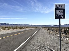
View from the west end of SR 168 looking eastbound in 2015
833:
828:
764:(Map) (1967 ed.). Nevada State Highway Department
741:(Map) (1939 ed.). Nevada Department of Highways
177:
163:
153:
143:
138:
115:
96:
91:
83:
75:
67:
54:
21:
403:American Association of State Highway Officials
8:
847:Template:Attached KML/Nevada State Route 168
528:Interchange; eastern terminus; I-15 exit 90
442:
223:
49:Nevada State Route 168, highlighted in red
850:
672:
670:
738:Official Road Map of the State of Nevada
702:
700:
576:
401:At a meeting held on June 8, 1931, the
883:Transportation in Clark County, Nevada
18:
16:State highway in Nevada, United States
609:Sherman, Frederick (April 23, 2006).
509:
503:
475:
469:
361:and running thence southerly through
7:
71:24.775 mi (39.871 km)
611:"The birth of Nevada's newest town"
585:Nevada Department of Transportation
454:
14:
708:"U.S. 93 Reaching For The Border"
405:(AASHO) approved an extension of
855:
559:
547:
510:
476:
385:
376:
244:
229:
119:
100:
43:
24:
335:Desert National Wildlife Refuge
317:from near Dead Man Wash in 2006
798:Official Highway Map of Nevada
761:Official Highway Map of Nevada
716:Federal Highway Administration
638:Official Highway Map of Nevada
343:Moapa River Indian Reservation
1:
449:
333:on the eastern border of the
186:Nevada State Highway System
899:
532:
527:
506:
498:
493:
472:
466:
461:
458:
453:
448:
445:
313:Looking west towards the
222:
182:
173:
134:
59:
42:
38:Glendale–Moapa Road
37:
878:State highways in Nevada
616:Las Vegas Review-Journal
554:United States portal
436:The entire route is in
862:Nevada State Route 168
318:
306:
566:U.S. Roads portal
312:
304:
864:at Wikimedia Commons
851:KML is from Wikidata
432:Major intersections
355:Nevada Legislature
319:
307:
860:Media related to
538:
537:
323:planned community
297:Route description
260:
259:
256:
255:
55:Route information
890:
859:
841:
814:
813:
811:
810:
793:
787:
786:
779:
773:
772:
770:
769:
756:
750:
749:
747:
746:
733:
727:
726:
724:
723:
704:
695:
694:
692:
691:
674:
665:
664:
662:
661:
648:
642:
641:
634:
628:
627:
625:
623:
606:
600:
599:
597:
595:
587:(January 2017).
581:
564:
563:
562:
552:
551:
550:
514:
513:
494:Western terminus
480:
479:
456:
451:
443:
389:
380:
252:
248:
247:
237:
233:
232:
224:
123:
122:
104:
103:
47:
28:
19:
898:
897:
893:
892:
891:
889:
888:
887:
868:
867:
852:
849:
844:
843:
842:
826:
822:
817:
808:
806:
795:
794:
790:
781:
780:
776:
767:
765:
758:
757:
753:
744:
742:
735:
734:
730:
721:
719:
712:Highway History
706:
705:
698:
689:
687:
676:
675:
668:
659:
657:
650:
649:
645:
636:
635:
631:
621:
619:
608:
607:
603:
593:
591:
583:
582:
578:
574:
560:
558:
548:
546:
543:
534:
511:
477:
434:
399:
398:
397:
396:
392:
391:
390:
382:
381:
351:
299:
263:State Route 168
245:
243:
230:
228:
120:
101:
92:Major junctions
50:
33:
32:
31:State Route 168
29:
17:
12:
11:
5:
896:
894:
886:
885:
880:
870:
869:
866:
865:
825:
824:
823:
821:
820:External links
818:
816:
815:
788:
774:
751:
728:
696:
666:
643:
629:
601:
575:
573:
570:
569:
568:
556:
542:
539:
536:
535:
530:
529:
526:
524:Salt Lake City
508:
505:
502:
496:
495:
492:
474:
471:
468:
464:
463:
460:
457:
452:
447:
433:
430:
394:
393:
384:
383:
375:
374:
373:
372:
371:
350:
347:
327:Coyote Springs
298:
295:
258:
257:
254:
253:
240:
238:
220:
219:
218:
217:
212:
210:Pre‑1976
207:
205:
200:
195:
189:
188:
180:
179:
178:Highway system
175:
174:
171:
170:
165:
161:
160:
155:
151:
150:
145:
141:
140:
136:
135:
132:
131:
117:
113:
112:
98:
94:
93:
89:
88:
85:
81:
80:
77:
73:
72:
69:
65:
64:
60:Maintained by
57:
56:
52:
51:
48:
40:
39:
35:
34:
30:
23:
22:
15:
13:
10:
9:
6:
4:
3:
2:
895:
884:
881:
879:
876:
875:
873:
863:
858:
854:
853:
848:
839:
835:
831:
830:
819:
805:on 2015-01-22
804:
800:
799:
792:
789:
784:
778:
775:
763:
762:
755:
752:
740:
739:
732:
729:
717:
713:
709:
703:
701:
697:
686:on 2015-06-13
685:
681:
680:
673:
671:
667:
655:
654:
647:
644:
639:
633:
630:
622:September 18,
618:
617:
612:
605:
602:
590:
586:
580:
577:
571:
567:
557:
555:
545:
544:
540:
531:
525:
521:
517:
501:
497:
491:
487:
483:
465:
444:
441:
439:
431:
429:
427:
422:
420:
416:
412:
408:
407:U.S. Route 93
404:
388:
379:
370:
368:
364:
360:
356:
348:
346:
344:
340:
336:
332:
328:
324:
316:
311:
303:
296:
294:
292:
288:
287:Interstate 15
284:
283:U.S. Route 93
280:
276:
272:
271:state highway
268:
264:
251:
241:
239:
236:
226:
225:
221:
216:
213:
211:
208:
206:
204:
201:
199:
196:
194:
191:
190:
187:
184:
183:
181:
176:
172:
169:
166:
162:
159:
156:
152:
149:
148:United States
146:
142:
137:
133:
130:
126:
118:
116:East end
114:
111:
108:northwest of
107:
99:
97:West end
95:
90:
86:
82:
78:
74:
70:
66:
63:
58:
53:
46:
41:
36:
27:
20:
827:
807:. Retrieved
803:the original
797:
791:
782:
777:
766:. Retrieved
760:
754:
743:. Retrieved
737:
731:
720:. Retrieved
718:. 2009-01-09
711:
688:. Retrieved
684:the original
678:
658:. Retrieved
652:
646:
637:
632:
620:. Retrieved
614:
604:
592:. Retrieved
579:
459:Destinations
438:Clark County
435:
423:
400:
352:
320:
275:Clark County
266:
262:
261:
185:
87:SR 7 by 1919
79:1976–present
426:renumbering
331:Sheep Range
315:Sheep Range
285:(US 93) to
250:SR 169
235:SR 167
872:Categories
809:2009-10-19
768:2009-10-19
745:2009-10-19
722:2009-10-19
690:2009-10-19
660:2009-06-02
572:References
482:US 93
289:(I-15) at
193:Interstate
106:US 93
520:Las Vegas
486:Las Vegas
415:Las Vegas
367:Las Vegas
829:KML file
679:Road Map
541:See also
518: –
500:Glendale
490:Caliente
484: –
446:Location
419:Caliente
291:Glendale
164:Counties
139:Location
129:Glendale
467:
349:History
269:) is a
144:Country
84:History
76:Existed
594:May 6,
363:Pioche
279:Nevada
267:SR 168
215:Scenic
158:Nevada
68:Length
507:39.88
504:24.78
462:Notes
411:Wells
339:Moapa
203:State
168:Clark
154:State
110:Moapa
838:help
834:edit
624:2010
596:2017
516:I-15
473:0.00
470:0.00
125:I-15
62:NDOT
365:to
359:Ely
325:of
273:in
127:in
874::
836:•
714:.
710:.
699:^
669:^
613:.
522:,
488:,
455:km
450:mi
440:.
277:,
242:→
227:←
198:US
840:)
832:(
812:.
771:.
748:.
725:.
693:.
663:.
626:.
598:.
265:(
Text is available under the Creative Commons Attribution-ShareAlike License. Additional terms may apply.