305:
556:
56:
438:
102:
37:
568:
466:
246:
231:
357:
380:. The route's northern terminus appears to have been shifted 8 miles (13 km) west of Coaldale around 1937. By 1941, SR 3A had been relocated to a new gravel road alignment which resembles that of present-day SR 264 and SR 773. The road was paved between US 6 and Dyer by 1949, and the remainder of the route received pavement by 1953.
490:
121:
383:
The
Dicalite Cutoff first appears on the state map in 1978. This was also the first edition to show State Route 3A being replaced by State Route 264 as part of the statewide renumbering of Nevada's highway system. The designations for current SR 264 and SR 773 were approved by the
304:
341:, where Fish Lake Valley Road turns off of the route. At this point, SR 264 curves northwest to follow the Dicalite Cutoff. The route reaches its terminus at US 6, approximately 5 miles (8.0 km) east of
598:
898:
388:
on July 1, 1976—the routing of these highways north of Fish Lake Valley was not made clear on state maps until 1991, when SR 773 was finally shown on the map.
544:
209:
337:, the highest point in the state of Nevada, comes into view on the west side of the highway. About 15 miles (24 km) north of Dyer is a junction with
856:
329:. From there, the highway follows Fish Lake Valley Road north to pass through the small community of Dyer. As the route heads north from Dyer through
364:
SR 3A first appears on state highway maps in 1933 as an unimproved road stretching from the
California–Nevada state line to the junction of
192:
852:
594:
69:
893:
353:
The southern 25 miles (40 km) of State Route 264 and all of State Route 773 were both previously designated State Route 3A.
772:
744:
322:
202:
109:
646:
385:
197:
373:
214:
640:
441:
326:
282:
105:
814:
397:
274:
167:
863:
293:. The majority of the route is known as Fish Lake Valley Road, with the northern portion referred to as the
369:
493:
469:
338:
334:
286:
249:
234:
124:
560:
365:
808:
501:
572:
535:
377:
330:
497:
777:(Map) (1978-79 ed.). Nevada Department of Highways. 1978. § E2. Archived from
342:
128:
887:
270:
147:
17:
290:
857:"Maps of Milepost Location on Nevada's Federal and State Highway System by County"
828:
778:
750:
720:
696:
672:
650:
618:
833:(Map) (1991-92 ed.). Nevada Department of Transportation. 1991. § E2
447:
318:
55:
36:
356:
749:(Map). Nevada Department of Highways. 1953. § F3. Archived from
278:
157:
543:
355:
303:
803:. Nevada Department of Transportation. January 2001. p. 104.
801:
Nevada State
Maintained Highways: Descriptions, Index and Maps
599:"State Maintained Highways of Nevada: Descriptions and Maps"
510:
1.000 mi = 1.609 km; 1.000 km = 0.621 mi
321:
State line approximately 4.3 miles (6.9 km) north of
360:
Much of SR 264 was originally designated State Route 3A.
27:
State highway in
Esmeralda County, Nevada, United States
531:
526:
725:(Map). Nevada Department of Highways. 1949. § F3
297:. A majority of the route was originally designated
308:
View from the north end of SR 264 looking southbound
177:
163:
153:
143:
138:
115:
96:
91:
83:
75:
62:
32:
8:
545:Template:Attached KML/Nevada State Route 264
899:Transportation in Esmeralda County, Nevada
701:(Map). Nevada Department of Highways. 1941
677:(Map). Nevada Department of Highways. 1937
589:
587:
402:
223:
548:
698:Official Road Map of the State of Nevada
674:Official Road Map of the State of Nevada
583:
806:
49:Fish Lake Valley Road, Dicalite Cutoff
29:
487:
481:
463:
457:
435:
429:
7:
79:33.667 mi (54.182 km)
853:Nevada Department of Transportation
595:Nevada Department of Transportation
414:
269:) is a 33.67-mile (54.19 km)
25:
566:
554:
488:
464:
436:
244:
229:
119:
100:
54:
35:
830:Official Highway Map of Nevada
774:Official Highway Map of Nevada
746:Official Highway Map of Nevada
722:Official Highway Map of Nevada
281:, United States. It connects
1:
647:Nevada Department of Highways
409:
386:Nevada Department of Highways
642:Official Road Map of Nevada
186:Nevada State Highway System
915:
327:California State Route 266
283:California State Route 266
509:
505:
484:
478:
474:
460:
454:
445:
432:
426:
421:
418:
413:
408:
405:
222:
182:
173:
134:
67:
53:
48:
894:State highways in Nevada
561:United States portal
549:KML is not from Wikidata
472:(Fish Lake Valley Road)
396:The entire route is in
289:(US 6) via the town of
649:. 1933. Archived from
361:
309:
573:U.S. Roads portal
359:
317:SR 264 begins at the
307:
18:Nevada State Route 3A
813:: CS1 maint: year (
446:Continuation beyond
781:on January 22, 2015
653:on December 5, 2012
392:Major intersections
869:on January 4, 2011
362:
310:
515:
514:
323:Oasis, California
313:Route description
260:
259:
256:
255:
63:Route information
16:(Redirected from
906:
879:
878:
876:
874:
868:
862:. Archived from
861:
849:
843:
842:
840:
838:
825:
819:
818:
812:
804:
797:
791:
790:
788:
786:
769:
763:
762:
760:
758:
753:on June 11, 2015
741:
735:
734:
732:
730:
717:
711:
710:
708:
706:
693:
687:
686:
684:
682:
669:
663:
662:
660:
658:
637:
631:
630:
628:
626:
621:. Peakbagger.com
615:
609:
608:
606:
605:
597:(January 2017).
591:
571:
570:
569:
559:
558:
557:
539:
492:
491:
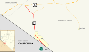
468:
467:
440:
439:
416:
411:
403:
398:Esmeralda County
331:Fish Lake Valley
275:Esmeralda County
252:
248:
247:
237:
233:
232:
224:
123:
122:
104:
103:
58:
39:
30:
21:
914:
913:
909:
908:
907:
905:
904:
903:
884:
883:
882:
872:
870:
866:
859:
851:
850:
846:
836:
834:
827:
826:
822:
805:
799:
798:
794:
784:
782:
771:
770:
766:
756:
754:
743:
742:
738:
728:
726:
719:
718:
714:
704:
702:
695:
694:
690:
680:
678:
671:
670:
666:
656:
654:
639:
638:
634:
624:
622:
619:"Boundary Peak"
617:
616:
612:
603:
601:
593:
592:
585:
581:
567:
565:
555:
553:
550:
547:
542:
541:
540:
524:
520:
511:
489:
465:
437:
394:
351:
339:State Route 773
315:
295:Dicalite Cutoff
263:State Route 264
245:
243:
230:
228:
120:
101:
92:Major junctions
44:
43:
42:State Route 264
40:
28:
23:
22:
15:
12:
11:
5:
912:
910:
902:
901:
896:
886:
885:
881:
880:
844:
820:
792:
764:
736:
712:
688:
664:
632:
610:
582:
580:
577:
576:
575:
563:
523:
522:
521:
519:
516:
513:
512:
507:
506:
504:
486:
483:
480:
476:
475:
473:
462:
459:
456:
452:
451:
444:
434:
431:
428:
424:
423:
420:
417:
412:
407:
393:
390:
376:(now US 6) at
374:State Route 15
350:
347:
314:
311:
299:State Route 3A
258:
257:
254:
253:
240:
238:
220:
219:
218:
217:
212:
210:Pre‑1976
207:
205:
200:
195:
189:
188:
180:
179:
178:Highway system
175:
174:
171:
170:
165:
161:
160:
155:
151:
150:
145:
141:
140:
136:
135:
132:
131:
117:
116:North end
113:
112:
98:
97:South end
94:
93:
89:
88:
85:
81:
80:
77:
73:
72:
68:Maintained by
65:
64:
60:
59:
51:
50:
46:
45:
41:
34:
33:
26:
24:
14:
13:
10:
9:
6:
4:
3:
2:
911:
900:
897:
895:
892:
891:
889:
865:
858:
854:
848:
845:
832:
831:
824:
821:
816:
810:
802:
796:
793:
780:
776:
775:
768:
765:
752:
748:
747:
740:
737:
724:
723:
716:
713:
700:
699:
692:
689:
676:
675:
668:
665:
652:
648:
644:
643:
636:
633:
620:
614:
611:
600:
596:
590:
588:
584:
578:
574:
564:
562:
552:
551:
546:
537:
533:
529:
528:
517:
508:
503:
499:
495:
477:
471:
453:
449:
443:
425:
404:
401:
399:
391:
389:
387:
381:
379:
375:
371:
367:
366:State Route 3
358:
354:
348:
346:
344:
340:
336:
335:Boundary Peak
332:
328:
324:
320:
312:
306:
302:
300:
296:
292:
288:
284:
280:
276:
272:
271:state highway
268:
264:
251:
241:
239:
236:
226:
225:
221:
216:
213:
211:
208:
206:
204:
201:
199:
196:
194:
191:
190:
187:
184:
183:
181:
176:
172:
169:
166:
162:
159:
156:
152:
149:
148:United States
146:
142:
137:
133:
130:
126:
118:
114:
111:
107:
99:
95:
90:
86:
82:
78:
74:
71:
66:
61:
57:
52:
47:
38:
31:
19:
871:. Retrieved
864:the original
855:(May 2008).
847:
835:. Retrieved
829:
823:
800:
795:
783:. Retrieved
779:the original
773:
767:
755:. Retrieved
751:the original
745:
739:
727:. Retrieved
721:
715:
703:. Retrieved
697:
691:
679:. Retrieved
673:
667:
655:. Retrieved
651:the original
641:
635:
623:. Retrieved
613:
602:. Retrieved
525:
419:Destinations
395:
382:
363:
352:
316:
298:
294:
291:Dyer, Nevada
287:U.S. Route 6
266:
262:
261:
185:
87:1976–present
873:January 11,
837:January 11,
785:January 11,
757:January 11,
729:January 11,
705:January 11,
681:January 11,
657:January 11,
625:January 11,
470:SR 773
442:SR 266
250:SR 265
235:SR 233
106:SR 266
888:Categories
604:2017-04-17
579:References
450:state line
448:California
319:California
193:Interstate
809:cite book
494:US 6
168:Esmeralda
125:US 6
110:Oasis, CA
527:KML file
518:See also
496: –
406:Location
378:Coaldale
164:Counties
139:Location
108:towards
645:(Map).
498:Tonopah
479:
455:
427:
349:History
144:Country
84:Existed
502:Bishop
372:) and
343:Basalt
279:Nevada
267:SR 264
215:Scenic
158:Nevada
129:Basalt
76:Length
867:(PDF)
860:(PDF)
485:54.19
482:33.67
461:40.97
458:25.46
422:Notes
370:US 95
368:(now
203:State
154:State
127:near
875:2009
839:2009
815:link
787:2009
759:2009
731:2009
707:2009
683:2009
659:2009
627:2009
536:help
532:edit
433:0.00
430:0.00
70:NDOT
325:on
285:to
273:in
890::
811:}}
807:{{
586:^
534:•
500:,
415:km
410:mi
400:.
345:.
333:,
301:.
277:,
242:→
227:←
198:US
877:.
841:.
817:)
789:.
761:.
733:.
709:.
685:.
661:.
629:.
607:.
538:)
530:(
265:(
20:)
Text is available under the Creative Commons Attribution-ShareAlike License. Additional terms may apply.