73:
106:
53:
735:
38:
533:
113:
80:
347:. The Mennonites built a church in 1656, and the Dutch Reformed followed in 1658. Most of the Mennonites left, and the congregation of Sinte Pier was dissolved in 1777. The Dutch Reformed church was damaged during World War II and restored in 1949.
329:
The village was first mentioned in 1514 as
Nieuvliet. "Vliet" means stream. Nieuw (new) was added to distinguish from another vliet, however there are multiple candidates. The current village developed after the Groote Sint Annapolder was
565:
716:
776:
72:
490:
800:
285:
558:
361:
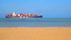
Nieuwvliet-Bad is a seaside resort near
Nieuwvliet. It has a very wide beach, and contains bungalow parks, campsites and recreational areas.
795:
297:
141:
105:
575:
551:
810:
769:
277:
52:
762:
173:
350:
Nieuwvliet was home to 830 people in 1840. It was a separate municipality until 1970, when it was merged with
343:
contained two hamlets: Nieuwvliet and Sinte Pier. Nieuwvliet was home to Dutch
Reformed, and Sint Pier to
537:
256:
37:
613:
266:
198:
188:
543:
746:
674:
382:
805:
789:
659:
433:
664:
312:
178:
734:
700:
669:
649:
603:
598:
503:
156:
143:
679:
344:
247:
532:
629:
608:
464:
351:
320:
742:
705:
634:
316:
695:
644:
332:
273:
252:
593:
579:
355:
324:
407:
639:
547:
750:
92:
Location in the province of
Zeeland in the Netherlands
688:
622:
586:
296:
284:
263:
246:
238:
230:
225:
217:
209:
204:
194:
184:
172:
21:
354:. In 2003, it became part of the municipality of
770:
717:List of cities, towns and villages in Zeeland
559:
8:
777:
763:
566:
552:
544:
18:
319:. It is located about 5 km north of
459:
457:
455:
369:
283:
245:
224:
216:
203:
171:
136:
64:
46:
34:
377:
375:
373:
491:Repertorium van Nederlandse gemeenten
295:
262:
237:
229:
208:
193:
183:
7:
731:
729:
383:"Kerncijfers wijken en buurten 2021"
213:12.03 km (4.64 sq mi)
489:Ad van der Meer and Onno Boonstra,
749:. You can help Knowledge (XXG) by
434:"Nieuwvliet - (geografische naam)"
112:
79:
14:
741:This article about a location in
801:Former municipalities of Zeeland
733:
531:
111:
104:
78:
71:
51:
36:
414:(in Dutch). Het Waterschapshuis
412:Actueel Hoogtebestand Nederland
16:Village in Zeeland, Netherlands
1:
387:Central Bureau of Statistics
796:Populated places in Zeeland
827:
728:
714:
408:"Postcodetool for 4504AA"
323:, in the municipality of
137:
65:
47:
35:
28:
574:Populated places in the
221:2.5 m (8.2 ft)
125:Nieuwvliet (Netherlands)
811:Zeeland geography stubs
128:Show map of Netherlands
265: • Summer (
242:33/km (86/sq mi)
614:Sint Anna ter Muiden
540:at Wikimedia Commons
311:is a village in the
239: • Density
157:51.37194°N 3.47139°E
153: /
95:Show map of Zeeland
42:Beach of Nieuwvliet
231: • Total
210: • Total
758:
757:
723:
722:
536:Media related to
339:Around 1650, the
306:
305:
162:51.37194; 3.47139
818:
779:
772:
765:
737:
730:
568:
561:
554:
545:
535:
520:
519:
517:
515:
504:"Nieuwvliet-Bad"
500:
494:
487:
481:
480:
478:
476:
461:
450:
449:
447:
445:
430:
424:
423:
421:
419:
404:
398:
397:
395:
393:
379:
270:
168:
167:
165:
164:
163:
158:
154:
151:
150:
149:
146:
129:
115:
114:
108:
96:
82:
81:
75:
55:
40:
19:
826:
825:
821:
820:
819:
817:
816:
815:
786:
785:
784:
783:
726:
724:
719:
710:
684:
675:Waterlandkerkje
618:
582:
572:
528:
523:
513:
511:
502:
501:
497:
488:
484:
474:
472:
463:
462:
453:
443:
441:
432:
431:
427:
417:
415:
406:
405:
401:
391:
389:
381:
380:
371:
367:
292:
264:
161:
159:
155:
152:
147:
144:
142:
140:
139:
133:
132:
131:
130:
127:
126:
123:
122:
121:
120:
116:
99:
98:
97:
94:
93:
90:
89:
88:
87:
83:
61:
60:
59:
58:
43:
31:
24:
17:
12:
11:
5:
824:
822:
814:
813:
808:
803:
798:
788:
787:
782:
781:
774:
767:
759:
756:
755:
738:
721:
720:
715:
712:
711:
709:
708:
703:
698:
692:
690:
686:
685:
683:
682:
677:
672:
667:
662:
657:
652:
647:
642:
637:
632:
626:
624:
620:
619:
617:
616:
611:
606:
601:
596:
590:
588:
584:
583:
573:
571:
570:
563:
556:
548:
542:
541:
527:
526:External links
524:
522:
521:
495:
493:, KNAW, 2011.
482:
451:
438:Etymologiebank
425:
399:
368:
366:
363:
304:
303:
300:
294:
293:
290:
288:
282:
281:
271:
261:
260:
250:
244:
243:
240:
236:
235:
232:
228:
227:
223:
222:
219:
215:
214:
211:
207:
206:
202:
201:
196:
192:
191:
186:
182:
181:
176:
170:
169:
135:
134:
124:
118:
117:
110:
109:
103:
102:
101:
100:
91:
85:
84:
77:
76:
70:
69:
68:
67:
66:
63:
62:
56:
50:
49:
48:
45:
44:
41:
33:
32:
29:
26:
25:
22:
15:
13:
10:
9:
6:
4:
3:
2:
823:
812:
809:
807:
804:
802:
799:
797:
794:
793:
791:
780:
775:
773:
768:
766:
761:
760:
754:
752:
748:
744:
739:
736:
732:
727:
718:
713:
707:
704:
702:
699:
697:
694:
693:
691:
687:
681:
678:
676:
673:
671:
668:
666:
663:
661:
660:Retranchement
658:
656:
653:
651:
648:
646:
643:
641:
638:
636:
633:
631:
628:
627:
625:
621:
615:
612:
610:
607:
605:
602:
600:
597:
595:
592:
591:
589:
585:
581:
577:
569:
564:
562:
557:
555:
550:
549:
546:
539:
534:
530:
529:
525:
509:
505:
499:
496:
492:
486:
483:
470:
466:
460:
458:
456:
452:
439:
435:
429:
426:
413:
409:
403:
400:
388:
384:
378:
376:
374:
370:
364:
362:
359:
357:
353:
348:
346:
342:
337:
335:
334:
327:
326:
322:
318:
314:
310:
301:
299:
289:
287:
279:
275:
272:
268:
258:
254:
251:
249:
241:
233:
220:
212:
200:
197:
190:
187:
180:
177:
175:
166:
138:Coordinates:
107:
74:
54:
39:
27:
20:
751:expanding it
740:
725:
654:
576:municipality
512:. Retrieved
508:Plaatsengids
507:
498:
485:
473:. Retrieved
469:Plaatsengids
468:
465:"Nieuwvliet"
442:. Retrieved
437:
428:
416:. Retrieved
411:
402:
390:. Retrieved
386:
360:
349:
340:
338:
331:
328:
315:province of
308:
307:
298:Dialing code
195:Municipality
57:Coat of arms
665:Schoondijke
286:Postal code
179:Netherlands
160: /
790:Categories
701:Slijkplaat
670:Sint Kruis
655:Nieuwvliet
650:Hoofdplaat
604:IJzendijke
599:Aardenburg
538:Nieuwvliet
510:(in Dutch)
471:(in Dutch)
440:(in Dutch)
365:References
345:Mennonites
336:in 1602.
309:Nieuwvliet
226:Population
145:51°22′19″N
119:Nieuwvliet
86:Nieuwvliet
23:Nieuwvliet
680:Zuidzande
248:Time zone
218:Elevation
148:3°28′17″E
630:Breskens
623:Villages
609:Oostburg
514:21 April
475:21 April
444:21 April
418:21 April
392:21 April
352:Oostburg
333:poldered
321:Oostburg
185:Province
743:Zeeland
706:Turkeye
689:Hamlets
635:Cadzand
317:Zeeland
189:Zeeland
174:Country
30:Village
696:Heille
645:Groede
341:polder
806:Sluis
745:is a
594:Sluis
587:Towns
580:Sluis
356:Sluis
325:Sluis
313:Dutch
274:UTC+2
253:UTC+1
199:Sluis
747:stub
640:Eede
516:2022
477:2022
446:2022
420:2022
394:2022
302:0117
291:4504
278:CEST
205:Area
578:of
267:DST
257:CET
234:400
792::
506:.
467:.
454:^
436:.
410:.
385:.
372:^
358:.
778:e
771:t
764:v
753:.
567:e
560:t
553:v
518:.
479:.
448:.
422:.
396:.
280:)
276:(
269:)
259:)
255:(
Text is available under the Creative Commons Attribution-ShareAlike License. Additional terms may apply.