170:
19:
68:
or settlements (Rangiura, Turamatuitui and
Pokoinu). Most of the people of Pokoinu lived near the sea, but after extensions were made to the airport, the people were moved inland towards the mountain. Today they call that new tapere, "Tepuka". The new village of Nikao has three new tapere (Panama,
69:
Atupa and Tepuka). Black Rock (Tuoro) is also located at Nikao beach, across the street from the Golf Club, where in oral tradition the spirits of the dead are believed to depart for
211:
230:
78:
240:
204:
57:
45:
197:
53:
61:
235:
181:
169:
49:
18:
224:
177:
125:
34:
148:
93:
80:
30:
70:
65:
38:
37:. It is located on the north coast to the west of the capital
185:
147:
Ruth H. Finnegan; Margaret Rose Orbell, eds. (1995).
52:(the oldest secondary school), Nikao's modern
205:
8:
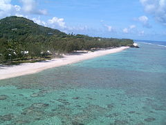
22:Nikao beach with Black Rock in the distance.
212:
198:
153:. Indiana University Press. p. 170.
17:
120:
118:
114:
64:Originally, Nikao consisted of three
60:and the first division football team
7:
231:Populated places in the Cook Islands
166:
164:
184:. You can help Knowledge (XXG) by
14:
168:
58:Rarotonga International Airport
46:Parliament of the Cook Islands
1:
150:South Pacific Oral Traditions
54:Cook Islands Christian Church
241:Cook Islands geography stubs
126:"Nikao chant and background"
29:is a village settlement on
257:
163:
94:21.2097806°S 159.8196611°W
99:-21.2097806; -159.8196611
44:Nikao is the home of the
180:location article is a
23:
21:
90: /
62:Nikao Sokattak F.C.
24:
193:
192:
248:
214:
207:
200:
172:
165:
155:
154:
144:
138:
137:
135:
133:
122:
105:
104:
102:
101:
100:
95:
91:
88:
87:
86:
83:
256:
255:
251:
250:
249:
247:
246:
245:
221:
220:
219:
218:
161:
159:
158:
146:
145:
141:
131:
129:
124:
123:
116:
111:
98:
96:
92:
89:
84:
81:
79:
77:
76:
50:Tereora College
12:
11:
5:
254:
252:
244:
243:
238:
233:
223:
222:
217:
216:
209:
202:
194:
191:
190:
173:
157:
156:
139:
113:
112:
110:
107:
85:159°49′10.78″W
13:
10:
9:
6:
4:
3:
2:
253:
242:
239:
237:
234:
232:
229:
228:
226:
215:
210:
208:
203:
201:
196:
195:
189:
187:
183:
179:
174:
171:
167:
162:
152:
151:
143:
140:
127:
121:
119:
115:
108:
106:
103:
82:21°12′35.21″S
74:
72:
67:
63:
59:
55:
51:
47:
42:
40:
36:
32:
28:
20:
16:
186:expanding it
178:Cook Islands
175:
160:
149:
142:
130:. Retrieved
128:. Tuatua Mai
75:
43:
35:Cook Islands
26:
25:
15:
97: /
225:Categories
109:References
236:Rarotonga
31:Rarotonga
132:11 March
33:in the
71:Avaiki
66:tapere
56:, the
39:Avarua
176:This
27:Nikao
182:stub
134:2013
227::
117:^
73:.
48:,
41:.
213:e
206:t
199:v
188:.
136:.
Text is available under the Creative Commons Attribution-ShareAlike License. Additional terms may apply.