42:
34:
26:
283:
70:
donated this land for a combined school and place of worship in the 1860s to be known as
Pevensey Sluice. It was later renamed Normans Bay when the railway halt of that name was first opened in 1905.
343:
324:
112:
In 2005 divers trying to free a lobster pot discovered a large anchor and cannons offshore. This was at first thought to be the remains of the
English warship
17:
67:
363:
244:
317:
41:
33:
353:
348:
310:
124:
82:
25:
358:
119:, which sunk there in 1703. However, ongoing research suggests the wreck might be that of the Dutch warship
113:
96:
55, two caravan sites and a The Star Inn public house. To the north is protected marshland known as
282:
144:
231:
170:
97:
294:
93:
57:
53:
337:
86:
290:
61:
74:
259:
246:
195:
101:
78:
219:
40:
32:
24:
52:(Normans' Bay on Ordnance Survey maps) is a coastal fishing
92:
Some points of interest include a sand and shingle beach,
298:
29:
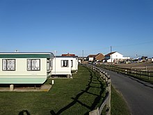
Normans Bay with
Martello Tower 55 in the foreground.
73:Normans Bay is near the popular seaside resorts of
318:
171:"Sussex Online Parish Clerks (OPC) home page"
8:
325:
311:
100:, and the abandoned medieval village of
344:Populated coastal places in East Sussex
136:
81:to the west, with a regular service at
18:Norman's Bay, Newfoundland and Labrador
7:
279:
277:
196:"The Story of Bexhill Street Names"
14:
16:For the Canadian settlement, see
281:
85:. The nearest bus service is in
1:
297:. You can help Knowledge by
364:East Sussex geography stubs
83:Normans Bay railway station
380:
276:
68:The 8th Duke of Devonshire
15:
37:The Star Inn public house
45:Normans Bay Caravan Park
354:Hamlets in East Sussex
349:Beaches of East Sussex
293:location article is a
220:The Resolution Project
145:"Normans' Bay, Rother"
46:
38:
30:
125:Battle of Beachy Head
44:
36:
28:
256: /
232:"Normans Bay Wreck"
260:50.8257°N 0.3929°E
200:bexhill-osm.org.uk
175:www.sussex-opc.org
123:, sunk during the
47:
39:
31:
306:
305:
151:. Ordnance Survey
121:Wapen van Utrecht
371:
327:
320:
313:
285:
278:
271:
270:
268:
267:
266:
261:
257:
254:
253:
252:
249:
236:
235:
228:
222:
217:
211:
210:
208:
206:
192:
186:
185:
183:
181:
167:
161:
160:
158:
156:
141:
379:
378:
374:
373:
372:
370:
369:
368:
334:
333:
332:
331:
274:
265:50.8257; 0.3929
264:
262:
258:
255:
250:
247:
245:
243:
242:
240:
239:
230:
229:
225:
218:
214:
204:
202:
194:
193:
189:
179:
177:
169:
168:
164:
154:
152:
143:
142:
138:
133:
110:
98:Pevensey Levels
21:
12:
11:
5:
377:
375:
367:
366:
361:
359:Bexhill-on-Sea
356:
351:
346:
336:
335:
330:
329:
322:
315:
307:
304:
303:
286:
238:
237:
223:
212:
187:
162:
135:
134:
132:
129:
109:
106:
94:Martello tower
58:Bexhill-on-Sea
13:
10:
9:
6:
4:
3:
2:
376:
365:
362:
360:
357:
355:
352:
350:
347:
345:
342:
341:
339:
328:
323:
321:
316:
314:
309:
308:
302:
300:
296:
292:
287:
284:
280:
275:
272:
269:
233:
227:
224:
221:
216:
213:
201:
197:
191:
188:
176:
172:
166:
163:
150:
146:
140:
137:
130:
128:
126:
122:
118:
117:
107:
105:
103:
99:
95:
90:
88:
84:
80:
76:
71:
69:
65:
63:
59:
55:
51:
43:
35:
27:
23:
19:
299:expanding it
288:
273:
241:
226:
215:
203:. Retrieved
199:
190:
178:. Retrieved
174:
165:
153:. Retrieved
148:
139:
120:
115:
111:
91:
87:Pevensey Bay
72:
66:
49:
48:
22:
291:East Sussex
263: /
64:, England.
62:East Sussex
50:Normans Bay
338:Categories
248:50°49′33″N
205:9 November
180:9 November
155:18 October
149:GetOutside
131:References
116:Resolution
75:Eastbourne
251:0°23′34″E
127:in 1690.
108:Shipwreck
102:Northeye
79:Brighton
54:hamlet
289:This
295:stub
207:2022
182:2022
157:2022
114:HMS
77:and
56:in
340::
198:.
173:.
147:.
104:.
89:.
60:,
326:e
319:t
312:v
301:.
234:.
209:.
184:.
159:.
20:.
Text is available under the Creative Commons Attribution-ShareAlike License. Additional terms may apply.