568:
These males were most likely community leaders who toted daggers in their daily lives. In addition, the location of
Normanton Down as a whole suggests a special burial site. It was laid out with clear and commanding views of Stonehenge and other ridge tops in every direction (except the north-west), and it is crossed by the same solstitial axis that passes through Stonehenge. Further study of Normanton Down has revealed an absence of flint-working on the site relative to its immediately surrounding areas. It seems the location was set apart from everyday activities and most likely carried special significance. Compared to other similar cemeteries, the Normanton Down location contains an uncommonly high number of
469:
543:" On reaching the floor of the barrow, we discovered the skeleton of a stout and tall man lying from south to north: the extreme length of his thigh bone was 20 inches. About 18 inches south of the head we found several brass (i. e. bronze) rivets intermixed with wood and some thin bits of brass nearly decomposed. These articles covered a space of 12 inches or more; it is probable therefore that they were the mouldered remains of a shield. Near the right arm was a large dagger of brass and a spearhead of the same material, full 13 inches long, and the largest we have ever found.
29:
458:
52:
547:
diminishing gradually towards the centre. We next discovered, on the right side of the skeleton, a very curious perforated stone, some wrought articles of bone, many small rings of the same material and another lozenge of gold. As this stone bears no marks of wear or attrition, I can hardly consider it to have been used as a domestic implement, and from the circumstances of it being composed of a mass of seaworms or little serpents, I think we may not be too fanciful in considering it an article of consequence."
45:
536:
artefacts surrounding it in the barrow. He described that the head of the grave was at the south and the body was positioned on the floor rather than in a pit, which was considered unusual. In the account, Cunnington described pieces of brass and wood that are now believed to be the remains of a rare type of dagger or knife. Modern reconstructions have led to the conclusion that the artefacts were arranged closely around the body.
433:. The Beaker graves contained various funerary goods and were usually covered by round barrows; however, most of these barrows did not survive, making the graves hard to locate. It is assumed that these Beaker burials are mostly to the west, in areas marked by older long or oval barrows. Also, mounds were later erected over some of the pre-existing Beaker graves, enabling early excavators to locate them.
492:
506:
476:
417:, funded by the Leverhulme Trust, began intensive studies of the artefacts found in all British Bronze Age burials, including those at Bush Barrow; and in 2010 an extensive survey of the condition and context of the barrows was made by English Heritage, as part of their Stonehenge World Heritage Site Landscape Project.
567:
The type and quantity of grave goods found at
Normanton Down suggest it was a burial place for people of high social status. Lavish burial configurations have also been identified. For example, the senior males found buried with daggers were originally placed in the grave lying on their left side.
444:
urns of middle Bronze Age manufacture are present in clusters of small mounds. In the same time period, the burials appear to decline on
Normanton Down, possibly shifting west to the vicinity of a remarkable feature known as the Wilsford shaft, which is a 30 metres (98 ft) deep shaft, within a
436:
Later, the layout of the cemetery changed dramatically. The
Normanton "linear" cemetery emerged along the main ridge, with three foci marking the landscape in a relatively straight line. Even though it is very likely that each focus was previously a Beaker grave, there is a clear tendency towards
535:
because of the trees planted on the top. It was previously known as "the green barrow" for the same reason. It was excavated in 1808 by
William Cunnington and Sir Richard Colt-Hoare, who found multiple artefacts inside the mound. Cunnington wrote a detailed account of the discovery of a body and
425:
The
Normanton Down site reveals the development of an entire Bronze Age cemetery. 24 barrows are covered by 6 different Scheduled Monument designations, and a total of at least 35 surviving barrows were identified and numbered by L V Grinsell in 1957. They appeared gradually throughout the Bronze
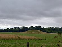
546:
Immediately over the breast of the skeleton was a large plate of gold, in the form of a lozenge and measuring 7 inches by 6 inches. The even surface of this noble ornament is relieved by indented lines, checks and zigzags, forming the shape of the outline, and forming lozenge within lozenge,
396:
times. Cunnington and Hoare noted four sets of "curiously huddled together" human remains in the east end of the Long barrow. Unlike many of the early excavations, Hoare published a detailed account of their findings in 1812. South of the long barrow lies a
375:
along the southern horizon, have been part of the scenery of
Salisbury Plain since 2000 BC. Barrow excavation was a popular hobby in the 18th and 19th centuries among amateur archaeologists, who became known as "barrow-diggers." In 1808,
468:
412:
in 1987, since which excavation of any sort has been even more strictly controlled. Recent study has therefore focussed on re-appraising existing finds and non-intrusive fieldwork. In 2007, researchers from the
776:
Grinsell, LV, 1957, 'Archaeological gazetteer' in Pugh, RB and
Crittall, E (eds) A History of Wiltshire 1: 1 The Victoria History of the Counties of England Oxford: OUP. 21-279
531:
The most famous burial mound at
Normanton Down is called Bush Barrow and is 40m wide and 3m high. The name "Bush Barrow" was given to this archaeological site in the 1720s by
854:
440:
Although most of the barrows were constructed by the end of the Early Bronze Age, a significant change appears in the middle of the Bronze Age. Burials involving
888:
636:
Hoare, RC, 1812, The
Ancient History of South Wiltshire. William Miller: London. (Facsimile edition published by EP Publishing/Wiltshire County Library, 1975)
898:
716:
918:
908:
75:
218:
88:
44:
437:
building sizeable mounds. Grave clustering seems to be present to some extent, especially in one of the Beaker burials and in the Bush Barrow.
913:
893:
701:
651:
187:
818:
674:
813:
669:
321:
317:
313:
309:
305:
301:
381:
269:
71:
903:
401:; this rectangular neolithic earthwork, now ploughed out, was discovered by aerial photography and excavated in 1959.
457:
28:
627:
Castleden, R. (1992). Neolithic Britain: New Stone Age Sites of England, Scotland and Wales. New York: Routledge.
414:
247:
731:
670:"Long barrow and 18 round barrows, forming the greater part of Normanton Down round barrow cemetery (1009614)"
814:"Pond barrow south of the A303 and 400m west of Normanton Gorse containing the 'Wilsford Shaft' (1010833)"
491:
388:. Almost all of these barrows are believed to be from the Bronze Age, but several features, including a
750:
520:
Boundary of the Stonehenge and Avebury World Heritage Site, with the location of Normanton Down Barrows
597:
559:, which preserves the manuscript notes made by Cunnington and the drawings made by Philip Crocker.
409:
207:
717:"Stonehenge World Heritage Site – Landscape Project: Normanton Down: Archaeological Survey Report"
355:
in Wiltshire, England. The burials date from between 2600 and 1600 BC and consist of a Neolithic
405:
398:
377:
345:
281:
175:
152:
723:
809:
665:
552:
532:
404:
Legal protection for many of the barrows was introduced in 1925 when they were designated a
842:
763:
441:
882:
577:
430:
429:
The early part of the Bronze Age was marked by Beaker burials, characteristic of the
360:
426:
Age. Multiple graves all covered by a single barrow are characteristic of the area.
796:
869:
573:
569:
526:
512:
505:
446:
389:
385:
356:
482:
475:
372:
352:
727:
103:
90:
393:
341:
384:
excavated several of the barrows, including the most important barrow, the
799:
Rethinking Bush Barrow. British Archaeology, (104) Retrieved 22 March 2009
556:
348:
259:
456:
722:. Research Department Report Series. 90–2010. English Heritage.
618:
Marsden, B. M. (1999). Early Barrow Diggers. Stroud: Tempus.
857:
Wiltshire Heritage Museum website. Retrieved 9 January 2010
872:
Ed. Christopher Catling. (2008). Retrieved 5 April 2009
797:
Needham, S., Lawson, A., Woodward, A. (Jan/Feb 2009).
551:
The finds from Bush Barrow are now displayed at the
296:
288:
279:
265:
255:
240:
232:
224:
214:
205:
201:
193:
182:
171:
163:
158:
148:
143:
135:
127:
119:
82:
67:
539:Below is an extract from Cunnington's account:
351:cemetery, about 0.6 miles (1 km) south of
51:
845:Collyer, Chris. Retrieved 22 March 2009 from
8:
371:The barrows of Normanton Down, visible from
21:
700:sfn error: no target: CITEREFBarrett2010 (
650:sfn error: no target: CITEREFBarrett2010 (
27:
20:
219:Stonehenge, Avebury and Associated Sites
838:
836:
792:
790:
788:
786:
784:
782:
695:
645:
589:
278:
865:
863:
759:
748:
889:Buildings and structures in Wiltshire
295:
287:
264:
254:
239:
231:
223:
213:
204:
7:
843:stone-circles.org.uk: Normanton Down
715:Barrett, Kate; Bowden, Mark (2010).
22:Normanton Down round barrow cemetery
819:National Heritage List for England
675:National Heritage List for England
363:, along the crest of a low ridge.
14:
899:Archaeological sites in Wiltshire
919:Scheduled monuments in Wiltshire
909:Sites associated with Stonehenge
504:
490:
474:
467:
50:
43:
359:and some 40 or more Bronze Age
33:Round barrow on Normanton Down
1:
914:Bronze Age sites in Wiltshire
461:Gold lozenge from Bush Barrow
894:Stone Age sites in Wiltshire
408:. The area was designated a
131:Stonehenge ritual landscape
935:
524:
208:UNESCO World Heritage Site
392:, are earlier, dating to
331:
327:
275:
197:Crossed by two bridleways
38:
26:
415:University of Birmingham
270:Europe and North America
598:"History of Stonehenge"
572:in addition to several
421:Development of the site
167:18th and 19th centuries
758:Cite journal requires
498:Normanton Down Barrows
462:
382:Sir Richard Colt Hoare
59:Shown within Wiltshire
460:
164:Excavation dates
123:Round barrow cemetery
410:World Heritage Site
186:Part managed as an
100: /
23:
904:Barrows in England
600:. English Heritage
463:
406:scheduled monument
399:mortuary enclosure
378:William Cunnington
297:Reference no.
282:Scheduled monument
256:Reference no.
194:Public access
176:William Cunnington
16:Barrows in England
335:
334:
251:
926:
873:
867:
858:
852:
846:
840:
831:
830:
828:
826:
810:Historic England
806:
800:
794:
777:
774:
768:
767:
761:
756:
754:
746:
744:
742:
736:
730:. Archived from
721:
712:
706:
705:
693:
687:
686:
684:
682:
666:Historic England
662:
656:
655:
643:
637:
634:
628:
625:
619:
616:
610:
609:
607:
605:
594:
553:Wiltshire Museum
533:William Stukeley
515:
508:
499:
494:
485:
478:
471:
300:(west to east):
245:
115:
114:
112:
111:
110:
105:
104:51.170°N 1.830°W
101:
98:
97:
96:
93:
78:
54:
53:
47:
31:
24:
934:
933:
929:
928:
927:
925:
924:
923:
879:
878:
877:
876:
868:
861:
853:
849:
841:
834:
824:
822:
808:
807:
803:
795:
780:
775:
771:
757:
747:
740:
738:
737:on 4 March 2016
734:
719:
714:
713:
709:
699:
694:
690:
680:
678:
664:
663:
659:
649:
644:
640:
635:
631:
626:
622:
617:
613:
603:
601:
596:
595:
591:
586:
565:
529:
523:
522:
521:
518:
517:
516:
511:
509:
501:
500:
497:
495:
487:
486:
481:
479:
455:
445:mid-Bronze Age
442:Deverel-Rimbury
423:
369:
284:
210:
108:
106:
102:
99:
94:
91:
89:
87:
86:
74:
63:
62:
61:
60:
57:
56:
55:
34:
17:
12:
11:
5:
932:
930:
922:
921:
916:
911:
906:
901:
896:
891:
881:
880:
875:
874:
859:
847:
832:
801:
778:
769:
760:|journal=
707:
688:
657:
638:
629:
620:
611:
588:
587:
585:
582:
564:
561:
525:Main article:
519:
510:
503:
502:
496:
489:
488:
480:
473:
472:
466:
465:
464:
454:
451:
422:
419:
368:
365:
338:Normanton Down
333:
332:
329:
328:
325:
324:
298:
294:
293:
290:
286:
285:
280:
277:
276:
273:
272:
267:
263:
262:
257:
253:
252:
242:
238:
237:
234:
230:
229:
226:
222:
221:
216:
212:
211:
206:
203:
202:
199:
198:
195:
191:
190:
184:
180:
179:
173:
172:Archaeologists
169:
168:
165:
161:
160:
156:
155:
150:
146:
145:
141:
140:
137:
133:
132:
129:
125:
124:
121:
117:
116:
109:51.170; -1.830
84:
80:
79:
72:grid reference
69:
65:
64:
58:
49:
48:
42:
41:
40:
39:
36:
35:
32:
15:
13:
10:
9:
6:
4:
3:
2:
931:
920:
917:
915:
912:
910:
907:
905:
902:
900:
897:
895:
892:
890:
887:
886:
884:
871:
866:
864:
860:
856:
851:
848:
844:
839:
837:
833:
821:
820:
815:
811:
805:
802:
798:
793:
791:
789:
787:
785:
783:
779:
773:
770:
765:
752:
733:
729:
725:
718:
711:
708:
703:
698:, p. 23.
697:
692:
689:
677:
676:
671:
667:
661:
658:
653:
648:, p. 41.
647:
642:
639:
633:
630:
624:
621:
615:
612:
599:
593:
590:
583:
581:
579:
578:saucer barrow
575:
571:
562:
560:
558:
554:
549:
548:
544:
540:
537:
534:
528:
514:
507:
493:
484:
477:
470:
459:
452:
450:
448:
443:
438:
434:
432:
431:Beaker people
427:
420:
418:
416:
411:
407:
402:
400:
395:
391:
387:
383:
379:
374:
366:
364:
362:
361:round barrows
358:
354:
350:
347:
343:
339:
330:
326:
323:
319:
315:
311:
307:
303:
299:
291:
283:
274:
271:
268:
261:
258:
249:
243:
235:
227:
220:
217:
215:Official name
209:
200:
196:
192:
189:
185:
181:
177:
174:
170:
166:
162:
157:
154:
151:
147:
142:
138:
134:
130:
126:
122:
118:
113:
85:
81:
77:
73:
70:
66:
46:
37:
30:
25:
19:
850:
823:. Retrieved
817:
804:
772:
751:cite journal
739:. Retrieved
732:the original
710:
696:Barrett 2010
691:
679:. Retrieved
673:
660:
646:Barrett 2010
641:
632:
623:
614:
602:. Retrieved
592:
574:bell barrows
570:disc barrows
566:
563:Significance
550:
545:
542:
541:
538:
530:
439:
435:
428:
424:
403:
370:
337:
336:
188:RSPB reserve
128:Part of
18:
527:Bush Barrow
513:Bush Barrow
453:Bush Barrow
447:Pond barrow
390:Long barrow
386:Bush Barrow
367:Excavations
357:long barrow
107: /
83:Coordinates
883:Categories
825:29 January
741:26 January
681:29 January
584:References
483:STONEHENGE
373:Stonehenge
353:Stonehenge
346:Bronze Age
289:Designated
241:Designated
236:i, ii, iii
178:and others
159:Site notes
153:Bronze Age
92:51°10′12″N
855:Galleries
728:1749-8775
394:neolithic
342:Neolithic
183:Ownership
139:1 km
95:1°49′48″W
576:and one
233:Criteria
228:Cultural
76:SU120412
68:Location
604:21 July
557:Devizes
322:1010330
318:1009616
314:1009615
310:1009614
306:1009618
302:1009617
248:session
149:Periods
144:History
726:
349:barrow
266:Region
246:(10th
136:Length
870:Salon
735:(PDF)
720:(PDF)
340:is a
244:1986
827:2015
764:help
743:2015
724:ISSN
702:help
683:2015
652:help
606:2016
380:and
344:and
292:1925
225:Type
120:Type
555:in
260:373
885::
862:^
835:^
816:.
812:.
781:^
755::
753:}}
749:{{
672:.
668:.
580:.
449:.
320:,
316:,
312:,
308:,
304:,
829:.
766:)
762:(
745:.
704:)
685:.
654:)
608:.
250:)
Text is available under the Creative Commons Attribution-ShareAlike License. Additional terms may apply.