62:
465:
95:
45:
481:
102:
69:
290:
368:
per crossing. Another crossing is from Isane to Stårheim. The final crossing is near the mouth of the fjord from the town of Måløy to
Oldeide. This final crossing also includes a stop at the island of Husevågøy in the middle of the fjord.
464:
545:
377:
There are numerous old fishing communities located along the fjord that date back to pre-Viking times. Some of the notable population centers along the fjord include the town of
148:
61:
348:. The fjord reaches a maximum-depth of 565 metres (1,854 ft) near the mouth of the Eidsfjorden and also by the village of Bryggja.
225:
94:
566:
594:
480:
386:
497:
252:
317:, Europe's largest mainland glacier, in the east and it flows west, emptying into the ocean just south of the
438:
333:
604:
520:
322:
337:
609:
361:
310:
356:
The fjord has no road or rail crossings, but it has three regular ferry crossings. There is an
302:
17:
614:
434:
574:
442:
394:
326:
298:
230:
44:
619:
314:
180:
599:
588:
446:
402:
357:
345:
450:
414:
410:
306:
271:
406:
378:
240:
426:
398:
341:
318:
163:
150:
422:
283:
275:
130:
471:
332:
There are several smaller fjords which branch off the main
Nordfjorden:
329:(with the smaller island of Husevågøy lying in the middle of the mouth).
134:
418:
390:
382:
267:
289:
321:
peninsula. The mouth of the fjord lies between the large islands of
259:
186:
430:
288:
263:
255:
279:
365:
524:
470:
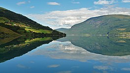
Panorama of the
Nordfjord from the mountain Hoven. The lake
381:(near the north side of the mouth in Kinn), the villages of
567:"Fjord1 vil ha slutt på "Tesla-tilstander" for elferjene"
297:
The 106-kilometre (66 mi) long fjord stretches from
286:
region which makes up the northern third of the county.
236:
224:
220:
212:
204:
196:
192:
179:
140:
126:
32:
141:
282:, and it is the central feature of the entire
8:
262:. It flows through the municipalities of
29:
474:can be seen in the left part of the image
509:
460:
313:. The fjord starts as runoff from the
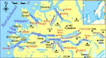
293:Map of the fjord and surrounding areas
515:
513:
7:
486:View of the Anda-Lote ferry crossing
101:
68:
25:
360:from Anda to Lote as part of the
479:
463:
100:
93:
67:
60:
43:
211:
203:
195:
18:Nordfjorden (Sogn og Fjordane)
1:
125:
208:2.5 kilometres (1.6 mi)
200:106 kilometres (66 mi)
636:
216:565 metres (1,854 ft)
54:
42:
37:
498:List of Norwegian fjords
294:
521:Store norske leksikon
292:
81:Location of the fjord
114:Nordfjorden (Norway)
84:Show map of Vestland
160: /
595:Fjords of Vestland
425:(in Gloppen); and
364:highway, using 75
362:European route E39
311:Stryn Municipality
305:to the village of
295:
164:61.8963°N 5.2759°E
117:Show map of Norway
548:. VisitNorway.com
303:Kinn Municipality
246:
245:
49:View of the fjord
16:(Redirected from
627:
579:
578:
577:. 2 August 2019.
573:(in Norwegian).
563:
557:
556:
554:
553:
542:
536:
535:
533:
532:
517:
483:
467:
401:(in Bremanger);
175:
174:
172:
171:
170:
165:
161:
158:
157:
156:
153:
143:
118:
104:
103:
97:
85:
71:
70:
64:
47:
30:
21:
635:
634:
630:
629:
628:
626:
625:
624:
585:
584:
583:
582:
575:Teknisk Ukeblad
565:
564:
560:
551:
549:
546:"The Nordfjord"
544:
543:
539:
530:
528:
519:
518:
511:
506:
494:
487:
484:
475:
468:
459:
375:
354:
327:Bremangerlandet
183: countries
169:61.8963; 5.2759
168:
166:
162:
159:
154:
151:
149:
147:
146:
122:
121:
120:
119:
116:
115:
112:
111:
110:
109:
105:
88:
87:
86:
83:
82:
79:
78:
77:
76:
72:
50:
28:
27:Fjord in Norway
23:
22:
15:
12:
11:
5:
633:
631:
623:
622:
617:
612:
607:
602:
597:
587:
586:
581:
580:
558:
537:
527:(in Norwegian)
508:
507:
505:
502:
501:
500:
493:
490:
489:
488:
485:
478:
476:
469:
462:
458:
455:
374:
371:
358:electric ferry
353:
352:Transportation
350:
315:Jostedalsbreen
244:
243:
238:
234:
233:
228:
222:
221:
218:
217:
214:
210:
209:
206:
202:
201:
198:
194:
193:
190:
189:
184:
177:
176:
144:
138:
137:
128:
124:
123:
113:
107:
106:
99:
98:
92:
91:
90:
89:
80:
74:
73:
66:
65:
59:
58:
57:
56:
55:
52:
51:
48:
40:
39:
35:
34:
26:
24:
14:
13:
10:
9:
6:
4:
3:
2:
632:
621:
618:
616:
613:
611:
608:
606:
603:
601:
598:
596:
593:
592:
590:
576:
572:
568:
562:
559:
547:
541:
538:
526:
525:"Nordfjorden"
522:
516:
514:
510:
503:
499:
496:
495:
491:
482:
477:
473:
466:
461:
457:Media gallery
456:
454:
452:
448:
444:
440:
436:
432:
428:
424:
420:
416:
412:
408:
404:
400:
396:
392:
388:
384:
380:
372:
370:
367:
363:
359:
351:
349:
347:
346:Gloppefjorden
343:
339:
335:
330:
328:
324:
320:
316:
312:
308:
304:
300:
291:
287:
285:
281:
277:
273:
269:
265:
261:
257:
254:
253:sixth longest
250:
242:
239:
235:
232:
229:
227:
223:
219:
215:
207:
199:
191:
188:
185:
182:
178:
173:
145:
139:
136:
132:
129:
96:
63:
53:
46:
41:
36:
31:
19:
605:Stad, Norway
570:
561:
550:. Retrieved
540:
529:. Retrieved
453:(in Stryn).
411:Nordfjordeid
376:
355:
338:Ålfotfjorden
331:
296:
248:
247:
417:(in Stad);
389:(in Stad);
373:Settlements
334:Eidsfjorden
249:Nordfjorden
237:Settlements
197:Max. length
167: /
142:Coordinates
108:Nordfjorden
75:Nordfjorden
33:Nordfjorden
589:Categories
552:2013-09-14
531:2013-09-14
504:References
427:Randabygda
403:Kjølsdalen
342:Hyefjorden
319:Stadlandet
301:island in
213:Max. depth
205:Max. width
152:61°53′47″N
610:Bremanger
423:Gimmestad
299:Husevågøy
284:Nordfjord
276:Bremanger
231:Husevågøy
155:5°16′33″E
131:Nordfjord
38:Nordfjord
492:See also
472:Lovatnet
407:Stårheim
135:Vestland
127:Location
615:Gloppen
419:Sandane
399:Ålfoten
391:Rugsund
387:Totland
383:Bryggja
268:Gloppen
251:is the
226:Islands
449:, and
435:Innvik
413:, and
397:, and
344:, and
323:Vågsøy
278:, and
260:Norway
187:Norway
620:Stryn
571:Tu.no
447:Olden
443:Stryn
439:Roset
431:Utvik
395:Davik
379:Måløy
264:Stryn
256:fjord
241:Måløy
181:Basin
600:Kinn
451:Loen
421:and
415:Lote
385:and
325:and
307:Loen
280:Kinn
272:Stad
366:kWh
309:in
258:in
591::
569:.
523:.
512:^
445:,
441:,
437:,
433:,
429:,
409:,
405:,
393:,
340:,
336:,
274:,
270:,
266:,
133:,
555:.
534:.
20:)
Text is available under the Creative Commons Attribution-ShareAlike License. Additional terms may apply.