1639:
542:, today it is used as a camp and conference center. The route is also noted for its back-road feel, a farm built in 1812, and the Mast General Store. The Valle Crucis, Shawneehaw and Elk Park Turnpike was built as a toll road between 1891 and 1892, by hand labor and without machinery. A particular four mile section is noted for its curves from the Valle Crucis Elementary School to Banner Elk, and for its scenic beauty. Today, the roadbed is part of North Carolina Highway 194.
1740:
90:
83:
816:
570:
721:
1487:
2061:
1658:
1665:
26:
395:
use NC 194 itself. It does not take the most direct route possible due to its endpoints and destinations, but instead meanders through the mountains, serving predominantly rural communities in the High
Country to provide access to outside communities. Because of this, it is not a route that is typically traveled for its entire length, or any significant part of its length.
1481:
1439:
1404:
1353:
1340:
1299:
1261:
1219:
1132:
1099:
1061:
1023:
986:
944:
906:
40:
1563:
1525:
2123:
1179:
1493:
1451:
1445:
1410:
1359:
1346:
1305:
1293:
1267:
1225:
1213:
1185:
1138:
1105:
1067:
1029:
992:
950:
912:
874:
335:
320:
192:
174:
169:
151:
146:
132:
108:
1569:
1531:
394:
The nature of NC 194 is one of a route that primarily serves local traffic. NC 194 may be thought of as a collection of individual routings under one number, as each segment serves its own local traffic and local needs—it is quicker to use other routes to get to another segment of NC 194 than to
479:
and US 321, passing through
Downtown Boone. US 321 exits this triplex, leaving on Blowing Rock Road. It becomes a duplex with US 421 until NC 105, where it becomes briefly triplexed with US 221 as once more, between NC 105 and Jefferson Road. Here, it exits the concurrencies. Heading north, it
705:
Between 1963 and 1968, NC 194 was realigned onto new road between
Newland and Elk Park, leaving behind Blevins Creek Road (SR 1361). In 1981, US 221/NC 194 was placed on road between Baldwin and West Jefferson, leaving behind Beaver Creek School Road (SR 1248).
779:, in Ingalls, to NC 194, near Linville Falls. In 1926, NC 691 was truncated further north from Linville Falls, at the east end of Three Mile Highway; the old alignment replaced by NC 194. In 1930, NC 691 was extended north, with a concurrency with US 221, to
515:
state line. On its trek there, it passes through several unincorporated communities: Bina, Lansing, Brandon, Sturgills, and Helton. Reaching the
Virginia line, it becomes a narrow, unmarked secondary road, numbered as SR 743 and named Rugby Road, which eventually connects to
1708:) redirects truckers traveling through either Banner Elk or Valle Crucis to not use the mainline highway between the two locations, with explicate flashing warning signs. This 15.2-mile (24.5 km) detour takes truckers, from Banner Elk, south along
548:
is an 32 miles (51 km) byway, split in two sections. The first section (18 miles (29 km)) is traversed by NC 194 from Boone to
Baldwin, passing through the community of Todd. The section is noted for its Christmas tree farms, the
537:
is an 18 miles (29 km) byway from Elk Park to Vilas, passing through the town of Banner Elk and the communities of Heaton, Balm, and Valle Crucis. The route gets its name from the 1895 mission built in Valle Crucis by the
2163:
419:, passing through Newland—this is a relatively straight stretch of road. A passing lane; one of few on NC 194 due to its mountainous nature, is available for southbound travelers between
495:, the road splits from US 221 for the final time. NC 194 goes through downtown West Jefferson, concurrent with US 221 Business before the latter route splits at West Second Street.
480:
travels through the unincorporated community of Sands, and provides access to Meat Camp. After passing through Sands, the route becomes narrow and curvy again, serving the community of
2158:
2168:
659:. The following year, NC 194 was re-extended south along US 221/NC 28, through Crossnore and Altamont, then replaced NC 691 to its current southern terminus in
1497:
617:
2112:
288:
531:
NC 194 is part of two scenic byway in the state (indicated by a Scenic Byways sign). Both routes are not recommended for recreational vehicles or buses.
1587:
53:
2153:
298:
293:
807:
replacing it with its former concurrency with US 221. In 1933, NC 691 was decommission with the extension of NC 194 to
Ingalls.
2007:
303:
2127:
451:
in Valle Crucis. In Banner Elk, drivers are met with numerous pedestrian crossings. The road provides access to the Elk River
Airport,
1454:
1414:
1367:
1363:
1309:
1233:
1071:
1033:
954:
916:
877:
819:
675:
667:
648:
581:
577:
539:
476:
408:
195:
177:
158:
135:
111:
1772:
460:
456:
371:
1425:
1160:
1113:
744:
687:
492:
257:
139:
1963:(Map). Cartography by NCSHC / USDOT / FHWA. North Carolina State Highway Commission – Planning and Research Department. 1968
1375:
280:
407:, on a moderately curvy stretch of road known as Three Mile Highway, eventually meeting its first of many junctions with
1955:
1928:
1901:
1874:
1688:
1549:
1275:
1165:
856:
796:
695:
508:
444:
253:
1385:
1037:
881:
601:
261:
1713:
1709:
1684:
1458:
1371:
1321:
1313:
1190:
1142:
1109:
1085:
996:
792:
784:
691:
625:
554:
440:
436:
338:
323:
181:
2034:
1847:
1817:
1573:
1539:
1535:
1501:
1462:
1009:
962:
930:
885:
823:
804:
800:
780:
776:
656:
652:
637:
613:
597:
589:
558:
517:
504:
412:
1511:
1317:
1237:
1146:
1075:
1047:
1000:
958:
788:
629:
605:
593:
416:
1390:
683:
488:
199:
1982:
1909:(Map). Cartography by NCSHC / NCSTC / U.S. Bureau of Public Roads. North Carolina State Tax Commission. 1936
1882:(Map). Cartography by NCSHC / NCSTC / U.S. Bureau of Public Roads. North Carolina State Tax Commission. 1930
972:
861:
740:
660:
609:
420:
404:
375:
115:
452:
920:
383:
367:
1247:
1200:
1150:
671:
641:
573:
511:. NC 194 from this point will not meet another route for its last 13.4 miles (21.6 km) to the
472:
432:
185:
162:
1638:
679:
550:
481:
1936:(Map). Cartography by NCHPWC / USPRA. North Carolina State Highway and Public Works Commission. 1953
1620:
803:
between Boone to Twin Oaks. In 1932, NC 691 was reverted to its pre-1930 alignment, with
2103:
1577:
612:
along its routing. In 1923, NC 194 was rerouted north from
Newland to NC 69, in
2138:
2133:
1779:
411:. On its first of three concurrences with US 221, the routes go through the town of
815:
1271:
1229:
783:; its new alignment replaced part of NC 194 to Crossnore, NC 181 to Pineola,
633:
569:
363:
243:
154:
620:, became Old Toe River Road (SR 1157). In 1924, NC 194 was extended to the
435:, the route becomes much more curvy, hugging the banks of several local waterways—The
2147:
1717:
448:
359:
233:
2066:
2012:
1745:
2042:(Map). Cartography by NCDOT. North Carolina Department of Transportation. 1940
415:, then separate after leaving the area. NC 194 then heads north towards
621:
1988:. North Carolina Department of Transportation. September 1, 1981. p. 4
1642:
One of several warning signs for truckers along this stretch of NC 194
2122:
1855:(Map). Cartography by NCSHC. North Carolina State Highway Commission. 1930
1825:(Map). Cartography by NCSHC. North Carolina State Highway Commission. 1922
1602:
699:
512:
379:
213:
1804:
1657:
720:
2111:
39:
1720:, it eventually reconnects with mainline NC 194 in Valle Crucis.
1712:
to
Tynecastle (a.k.a. Invershield or Linville Gap), then north along
503:
From West
Jefferson, NC 194 continues heading north, duplexing with
1664:
1637:
1559:
1521:
1477:
1467:
North end of US 221 and south end of US 221 Bus. overlap
1435:
1400:
1336:
1290:
1257:
1210:
1128:
1095:
1057:
1019:
940:
902:
814:
568:
557:
engagement, and the Todd General Store. The second section is on
25:
588:
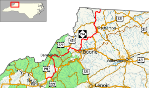
NC 194 is an original state highway that traveled between
443:, the Craborchard Creek from the Watauga–Avery County line to
1778:. North Carolina Department of Transportation. Archived from
1380:
North end of US 221 and south end of US 421 overlap
644:; its former routing to Tennessee became part of NC 69.
1610:
1.000 mi = 1.609 km; 1.000 km = 0.621 mi
523:
The highway is the northernmost primary route in the state.
775:) was established in 1925 as a new primary routing between
2062:"NC 194 Truck - Banner Elk–Valle Crucis, North Carolina"
666:
Around 1953, NC 194 was extended from Vilas, along
491:, the road widens, and is briefly a divided highway. In
403:
NC 194 begins heading due east in the community of
2099:
2094:
455:, and provides access via NC 184 to the ski resorts on
1581:
1543:
1505:
1466:
1419:
1379:
1325:
1279:
1241:
1154:
1117:
1079:
1041:
966:
924:
628:. In 1930, NC 194 replaced NC 69 north of
1694:
1680:
1653:
758:
750:
736:
716:
271:
249:
239:
229:
224:
208:
121:
102:
97:
75:
67:
59:
46:
21:
2164:Transportation in Watauga County, North Carolina
2113:Template:Attached KML/North Carolina Highway 194
2159:Transportation in Avery County, North Carolina
1155:South end of NC 184 overlap; to Ski Sugar
1118:North end of NC 184 overlap; to Ski Beech
2169:Transportation in Ashe County, North Carolina
507:, starting in Smethport and continuing until
8:
1805:Valle Crucis: A History of an Uncommon Place
1242:North end of US 321/US 421 overlap
674:, then north replacing an old alignment of
1716:to Broadstone Road (SR-1112); hugging the
828:
616:; its old alignment, which paralleled the
312:
2116:
1842:
1840:
499:West Jefferson to the Virginia state line
1767:
1765:
1763:
698:to its current northern terminus at the
561:, between Jefferson and Laurel Springs.
1729:
1957:North Carolina County Road Survey 1968
1930:North Carolina County Road Survey 1953
1903:North Carolina County Road Survey 1936
1876:North Carolina County Road Survey 1930
1849:State Highway System of North Carolina
1819:State Highway System of North Carolina
1650:
1112:north (Beech Mountain Parkway) –
957:north (Linville Falls Highway) –
919:south (Linville Falls Highway) –
713:
18:
2036:North Carolina Primary Highway System
1597:
1591:
1553:
1515:
1506:North end of US 221 Bus. overlap
1471:
1429:
1394:
1330:
1316:south (Highway 105 Extension) –
1284:
1251:
1204:
1175:
1169:
1122:
1089:
1051:
1013:
982:
976:
934:
896:
871:
865:
647:In 1932, NC 194 was replaced by
7:
1735:
1733:
1807:. : I.H. Hughes, 1995. Pages 89-90.
1647:Banner Elk–Valle Crucis truck route
686:. Overlapping with US 221 to
16:State highway in North Carolina, US
1704:North Carolina Highway 194 Truck (
843:
484:as a North Carolina Scenic Byway.
14:
1145:south (Shawneehaw Avenue) –
487:Reconnecting with US 221 in
63:85.5 mi (137.6 km)
2154:State highways in North Carolina
2121:
1698:15.2 mi (24.5 km)
1670:North Carolina Highway 194 Truck
1663:
1656:
1567:
1561:
1529:
1523:
1491:
1485:
1479:
1449:
1443:
1437:
1420:South end of US 221 overlap
1408:
1402:
1357:
1351:
1344:
1338:
1326:South end of US 221 overlap
1303:
1297:
1291:
1280:South end of US 321 overlap
1265:
1259:
1223:
1217:
1211:
1183:
1177:
1136:
1130:
1103:
1097:
1080:North end of US 19E overlap
1065:
1059:
1042:South end of US 19E overlap
1027:
1021:
990:
984:
967:North end of US 221 overlap
948:
942:
925:South end of US 221 overlap
910:
904:
872:
719:
333:
318:
190:
172:
167:
149:
144:
130:
106:
88:
81:
38:
24:
999:south (Linville Avenue) –
1773:"North Carolina Scenic Byways"
1582:West end of NC 88 overlap
1544:East end of NC 88 overlap
754:4.2 mi (6.8 km)
1:
1274:south (Hardin Street) –
838:
281:North Carolina Highway System
2008:"North Carolina Highway 691"
1741:"North Carolina Highway 194"
1983:"Route Change (1981-09-01)"
2185:
2128:North Carolina Highway 194
769:North Carolina Highway 691
726:North Carolina Highway 691
710:North Carolina Highway 691
352:North Carolina Highway 194
31:North Carolina Highway 194
1676:
1609:
1600:
1594:
1586:
1556:
1548:
1518:
1510:
1474:
1432:
1424:
1397:
1389:
1384:
1333:
1287:
1254:
1246:
1207:
1199:
1195:
1172:
1164:
1159:
1125:
1092:
1084:
1054:
1046:
1016:
1008:
1004:
979:
971:
937:
929:
899:
893:
889:
868:
860:
855:
850:
847:
842:
837:
834:
831:
732:
311:
276:
267:
220:
51:
37:
1616:
618:ETWN "Tweetsie" Railroad
1193: / Broadstone Road
655:, between Woodlawn and
475:, it is triplexed with
467:Vilas to West Jefferson
439:, between Elk Park and
1643:
826:
624:state line, replacing
585:
546:New River Valley Byway
535:Mission Crossing Byway
93:New River Valley Byway
86:Mission Crossing Byway
2139:NCRoads.com: N.C. 691
2134:NCRoads.com: N.C. 194
1641:
818:
572:
431:Between Elk Park and
362:in the U.S. state of
2130:at Wikimedia Commons
2117:KML is from Wikidata
1803:Hughes, I. Harding.
1601:Continuation beyond
551:North Fork New River
1785:on October 20, 2012
690:, it then replaces
471:From Vilas through
399:Ingalls to Elk Park
123:Major intersections
1644:
827:
745:Linville Falls, NC
586:
453:Lees–McRae College
366:. Entirely in the
212:Rugby Road at the
2126:Media related to
1706:NC 194 Truck
1702:
1701:
1631:
1630:
766:
765:
555:Revolutionary War
427:Elk Park to Vilas
390:Route description
382:state line, near
349:
348:
345:
344:
47:Route information
2176:
2125:
2107:
2079:
2078:
2076:
2074:
2058:
2052:
2051:
2049:
2047:
2041:
2031:
2025:
2024:
2022:
2020:
2004:
1998:
1997:
1995:
1993:
1987:
1979:
1973:
1972:
1970:
1968:
1962:
1952:
1946:
1945:
1943:
1941:
1935:
1925:
1919:
1918:
1916:
1914:
1908:
1898:
1892:
1891:
1889:
1887:
1881:
1871:
1865:
1864:
1862:
1860:
1854:
1844:
1835:
1834:
1832:
1830:
1824:
1814:
1808:
1801:
1795:
1794:
1792:
1790:
1784:
1777:
1769:
1758:
1757:
1755:
1753:
1737:
1689:Valle Crucis, NC
1667:
1660:
1651:
1624:
1617:
1572:
1571:
1570:
1565:
1564:
1534:
1533:
1532:
1527:
1526:
1498:US 221 Bus.
1496:
1495:
1494:
1489:
1488:
1483:
1482:
1453:
1452:
1448:
1447:
1446:
1441:
1440:
1413:
1412:
1411:
1406:
1405:
1362:
1361:
1360:
1355:
1354:
1349:
1348:
1347:
1342:
1341:
1308:
1307:
1306:
1301:
1300:
1295:
1294:
1270:
1269:
1268:
1263:
1262:
1228:
1227:
1226:
1221:
1220:
1215:
1214:
1188:
1187:
1186:
1181:
1180:
1141:
1140:
1139:
1134:
1133:
1108:
1107:
1106:
1101:
1100:
1070:
1069:
1068:
1063:
1062:
1032:
1031:
1030:
1025:
1024:
995:
994:
993:
988:
987:
953:
952:
951:
946:
945:
915:
914:
913:
908:
907:
876:
875:
845:
840:
829:
822:/NC 194 in
723:
714:
540:Episcopal Church
341:
337:
336:
326:
322:
321:
313:
194:
193:
176:
175:
171:
170:
153:
152:
148:
147:
134:
133:
124:
110:
109:
92:
91:
85:
84:
42:
28:
19:
2184:
2183:
2179:
2178:
2177:
2175:
2174:
2173:
2144:
2143:
2118:
2115:
2110:
2109:
2108:
2092:
2088:
2083:
2082:
2072:
2070:
2060:
2059:
2055:
2045:
2043:
2039:
2033:
2032:
2028:
2018:
2016:
2006:
2005:
2001:
1991:
1989:
1985:
1981:
1980:
1976:
1966:
1964:
1960:
1954:
1953:
1949:
1939:
1937:
1933:
1927:
1926:
1922:
1912:
1910:
1906:
1900:
1899:
1895:
1885:
1883:
1879:
1873:
1872:
1868:
1858:
1856:
1852:
1846:
1845:
1838:
1828:
1826:
1822:
1816:
1815:
1811:
1802:
1798:
1788:
1786:
1782:
1775:
1771:
1770:
1761:
1751:
1749:
1739:
1738:
1731:
1726:
1672:
1671:
1668:
1661:
1649:
1636:
1627:
1619:
1615:
1611:
1588:Helton Township
1568:
1566:
1562:
1560:
1530:
1528:
1524:
1522:
1492:
1490:
1486:
1484:
1480:
1478:
1450:
1444:
1442:
1438:
1436:
1409:
1407:
1403:
1401:
1358:
1356:
1352:
1350:
1345:
1343:
1339:
1337:
1304:
1302:
1298:
1296:
1292:
1266:
1264:
1260:
1258:
1224:
1222:
1218:
1216:
1212:
1184:
1182:
1178:
1176:
1137:
1135:
1131:
1129:
1104:
1102:
1098:
1096:
1066:
1064:
1060:
1058:
1028:
1026:
1022:
1020:
991:
989:
985:
983:
949:
947:
943:
941:
911:
909:
905:
903:
873:
813:
728:
727:
724:
712:
567:
529:
501:
469:
429:
401:
392:
370:, it runs from
358:) is a primary
334:
332:
319:
317:
204:
191:
173:
168:
150:
145:
131:
122:
107:
98:Major junctions
89:
87:
82:
77:
33:
32:
29:
17:
12:
11:
5:
2182:
2180:
2172:
2171:
2166:
2161:
2156:
2146:
2145:
2142:
2141:
2136:
2131:
2091:
2090:
2089:
2087:
2086:External links
2084:
2081:
2080:
2053:
2026:
1999:
1974:
1947:
1920:
1893:
1866:
1836:
1809:
1796:
1759:
1728:
1727:
1725:
1722:
1700:
1699:
1696:
1692:
1691:
1682:
1678:
1677:
1674:
1673:
1669:
1662:
1655:
1654:
1648:
1645:
1635:
1634:Special routes
1632:
1629:
1628:
1626:
1625:
1612:
1607:
1606:
1599:
1596:
1593:
1590:
1584:
1583:
1580:
1558:
1555:
1552:
1546:
1545:
1542:
1520:
1517:
1514:
1508:
1507:
1504:
1476:
1473:
1469:
1468:
1465:
1434:
1431:
1428:
1426:West Jefferson
1422:
1421:
1418:
1399:
1396:
1393:
1388:
1382:
1381:
1378:
1335:
1332:
1328:
1327:
1324:
1289:
1286:
1282:
1281:
1278:
1256:
1253:
1250:
1244:
1243:
1240:
1209:
1206:
1203:
1197:
1196:
1194:
1174:
1171:
1168:
1163:
1157:
1156:
1153:
1127:
1124:
1120:
1119:
1116:
1114:Beech Mountain
1094:
1091:
1088:
1082:
1081:
1078:
1056:
1053:
1050:
1044:
1043:
1040:
1018:
1015:
1012:
1006:
1005:
1003:
981:
978:
975:
969:
968:
965:
939:
936:
933:
927:
926:
923:
901:
898:
895:
891:
890:
888:
870:
867:
864:
859:
853:
852:
849:
846:
841:
836:
833:
812:
809:
764:
763:
760:
756:
755:
752:
748:
747:
738:
734:
733:
730:
729:
725:
718:
717:
711:
708:
688:West Jefferson
566:
563:
553:, a site of a
528:
525:
500:
497:
493:West Jefferson
468:
465:
428:
425:
423:and Elk Park.
400:
397:
391:
388:
364:North Carolina
347:
346:
343:
342:
329:
327:
309:
308:
307:
306:
301:
296:
291:
285:
284:
274:
273:
272:Highway system
269:
268:
265:
264:
251:
247:
246:
244:North Carolina
241:
237:
236:
231:
227:
226:
222:
221:
218:
217:
210:
209:North end
206:
205:
203:
202:
188:
165:
142:
140:Linville Falls
127:
125:
119:
118:
104:
103:South end
100:
99:
95:
94:
79:
73:
72:
69:
65:
64:
61:
57:
56:
52:Maintained by
49:
48:
44:
43:
35:
34:
30:
23:
22:
15:
13:
10:
9:
6:
4:
3:
2:
2181:
2170:
2167:
2165:
2162:
2160:
2157:
2155:
2152:
2151:
2149:
2140:
2137:
2135:
2132:
2129:
2124:
2120:
2119:
2114:
2105:
2101:
2097:
2096:
2085:
2069:
2068:
2063:
2057:
2054:
2038:
2037:
2030:
2027:
2015:
2014:
2009:
2003:
2000:
1984:
1978:
1975:
1959:
1958:
1951:
1948:
1932:
1931:
1924:
1921:
1905:
1904:
1897:
1894:
1878:
1877:
1870:
1867:
1851:
1850:
1843:
1841:
1837:
1821:
1820:
1813:
1810:
1806:
1800:
1797:
1781:
1774:
1768:
1766:
1764:
1760:
1748:
1747:
1742:
1736:
1734:
1730:
1723:
1721:
1719:
1718:Watauga River
1715:
1711:
1707:
1697:
1693:
1690:
1686:
1683:
1679:
1675:
1666:
1659:
1652:
1646:
1640:
1633:
1622:
1614:
1613:
1608:
1604:
1589:
1585:
1579:
1575:
1551:
1547:
1541:
1537:
1513:
1509:
1503:
1500:north –
1499:
1470:
1464:
1460:
1457:north /
1456:
1427:
1423:
1416:
1392:
1387:
1383:
1377:
1376:Winston-Salem
1373:
1370:south –
1369:
1366:north /
1365:
1329:
1323:
1319:
1315:
1311:
1283:
1277:
1273:
1249:
1245:
1239:
1238:Mountain City
1236:north –
1235:
1231:
1202:
1198:
1192:
1167:
1162:
1158:
1152:
1148:
1144:
1121:
1115:
1111:
1087:
1083:
1077:
1076:Roan Mountain
1074:north –
1073:
1049:
1045:
1039:
1036:south –
1035:
1011:
1007:
1002:
998:
974:
970:
964:
960:
956:
932:
928:
922:
918:
892:
887:
883:
879:
863:
858:
854:
830:
825:
821:
817:
811:Junction list
810:
808:
806:
802:
798:
794:
790:
786:
782:
778:
774:
770:
761:
757:
753:
749:
746:
742:
739:
735:
731:
722:
715:
709:
707:
703:
701:
697:
693:
689:
685:
681:
677:
673:
669:
664:
662:
658:
654:
650:
645:
643:
639:
635:
631:
627:
623:
619:
615:
611:
607:
604:; connecting
603:
599:
595:
591:
584:/NC 194)
583:
579:
576:King Street (
575:
571:
564:
562:
560:
556:
552:
547:
543:
541:
536:
532:
527:Scenic byways
526:
524:
521:
519:
514:
510:
506:
498:
496:
494:
490:
485:
483:
478:
474:
466:
464:
462:
458:
454:
450:
449:Watauga River
446:
442:
438:
434:
426:
424:
422:
418:
414:
410:
406:
398:
396:
389:
387:
385:
381:
377:
373:
369:
365:
361:
360:state highway
357:
353:
340:
330:
328:
325:
315:
314:
310:
305:
302:
300:
297:
295:
292:
290:
287:
286:
283:
282:
278:
277:
275:
270:
266:
263:
259:
255:
252:
248:
245:
242:
238:
235:
234:United States
232:
228:
223:
219:
215:
211:
207:
201:
197:
189:
187:
183:
179:
166:
164:
160:
156:
143:
141:
137:
129:
128:
126:
120:
117:
113:
105:
101:
96:
80:
74:
70:
66:
62:
58:
55:
50:
45:
41:
36:
27:
20:
2093:
2071:. Retrieved
2065:
2056:
2044:. Retrieved
2035:
2029:
2017:. Retrieved
2011:
2002:
1990:. Retrieved
1977:
1965:. Retrieved
1956:
1950:
1938:. Retrieved
1929:
1923:
1911:. Retrieved
1902:
1896:
1884:. Retrieved
1875:
1869:
1857:. Retrieved
1848:
1827:. Retrieved
1818:
1812:
1799:
1787:. Retrieved
1780:the original
1750:. Retrieved
1744:
1705:
1703:
1618:
1576:west –
1550:Warrensville
1538:east –
1276:Blowing Rock
1166:Valle Crucis
848:Destinations
797:Blowing Rock
772:
768:
767:
704:
702:state line.
696:Warrensville
665:
646:
587:
545:
544:
534:
533:
530:
522:
509:Warrensville
502:
486:
470:
445:Valle Crucis
430:
402:
393:
368:High Country
355:
351:
350:
279:
71:1921–present
2073:December 4,
2067:Google Maps
2013:Google Maps
1746:Google Maps
1714:NC 105
1710:NC 184
1621:Concurrency
1459:NC 163
1455:US 221
1415:US 221
1368:US 421
1364:US 221
1314:NC 105
1310:US 221
1272:US 321
1234:US 421
1230:US 321
1191:NC 105
1143:NC 184
1110:NC 184
1072:US 19E
1038:Spruce Pine
1034:US 19E
997:NC 181
955:US 221
917:US 221
882:Spruce Pine
878:US 19E
820:US 19E
793:NC 175
785:NC 176
773:NC 691
692:NC 162
676:US 221
668:US 421
649:US 221
634:US 321
626:NC 694
602:Minneapolis
582:US 421
578:US 321
477:US 421
409:US 221
372:US 19E
356:NC 194
339:NC 197
324:NC 191
196:US 221
182:NC 105
178:US 221
159:US 421
155:US 321
136:US 221
112:US 19E
2148:Categories
1724:References
1685:Banner Elk
1605:state line
1598:Rugby Road
1574:NC 88
1536:NC 88
1372:Wilkesboro
1322:Banner Elk
1086:Banner Elk
805:NC 28
801:NC 69
777:NC 69
653:NC 28
638:NC 60
598:NC 69
590:NC 19
518:US 58
505:NC 88
463:Mountain.
447:, and the
441:Banner Elk
289:Interstate
216:state line
1540:Jefferson
1512:Smethport
1502:Jefferson
1463:Jefferson
1010:Cranberry
963:Morganton
931:Crossnore
886:Cranberry
824:Cranberry
781:Twin Oaks
762:1925–1933
657:Crossnore
622:Tennessee
614:Cranberry
437:Elk River
413:Crossnore
378:, to the
2095:KML file
2046:March 7,
2019:March 7,
1859:March 7,
1681:Location
1623:terminus
1603:Virginia
1461: –
1318:Linville
1312: /
1232: /
1147:Linville
1048:Elk Park
1001:Linville
959:Linville
880: –
835:Location
789:Linville
737:Location
700:Virginia
694:through
678:through
670:through
630:Elk Park
606:Altamont
594:Woodlawn
513:Virginia
417:Elk Park
380:Virginia
250:Counties
225:Location
214:Virginia
180: /
157: /
2064:(Map).
2010:(Map).
1992:May 16,
1967:May 16,
1940:May 16,
1913:May 16,
1886:May 16,
1829:May 16,
1789:May 16,
1752:May 16,
1743:(Map).
1391:Baldwin
1161:Watauga
973:Newland
894:
862:Ingalls
759:Existed
743:–
741:Ingalls
684:Baldwin
661:Ingalls
610:Newland
574:Boone's
565:History
489:Baldwin
421:Newland
405:Ingalls
376:Ingalls
258:Watauga
230:Country
200:Baldwin
116:Ingalls
76:Tourist
68:Existed
1695:Length
921:Marion
832:County
751:Length
596:, and
384:Helton
304:Scenic
78:routes
60:Length
2040:(PDF)
1986:(PDF)
1961:(PDF)
1934:(PDF)
1907:(PDF)
1880:(PDF)
1853:(PDF)
1823:(PDF)
1783:(PDF)
1776:(PDF)
1595:137.6
1578:Trade
1557:116.4
1519:110.2
1475:107.8
1433:105.1
1417:south
1248:Boone
1201:Vilas
1151:Boone
857:Avery
851:Notes
672:Boone
642:Vilas
640:, in
600:, in
592:, in
559:NC 88
473:Boone
461:Sugar
457:Beech
433:Vilas
374:, in
299:State
254:Avery
240:State
186:Boone
163:Vilas
138:near
54:NCDOT
2104:help
2100:edit
2075:2013
2048:2016
2021:2016
1994:2015
1969:2015
1942:2015
1915:2015
1888:2015
1861:2016
1831:2015
1791:2015
1754:2015
1592:85.5
1554:72.3
1516:68.5
1472:67.0
1430:65.3
1398:99.3
1395:61.7
1386:Ashe
1334:70.2
1331:43.6
1288:69.2
1285:43.0
1255:68.7
1252:42.7
1208:59.5
1205:37.0
1173:53.6
1170:33.3
1126:41.5
1123:25.8
1093:41.0
1090:25.5
1055:30.4
1052:18.9
1017:29.9
1014:18.6
980:20.9
977:13.0
938:14.6
799:and
680:Todd
608:and
482:Todd
459:and
262:Ashe
1189:To
935:9.1
900:6.8
897:4.2
869:0.0
866:0.0
795:to
787:to
682:to
632:to
386:.
198:in
184:in
161:in
114:in
2150::
2102:•
1839:^
1762:^
1732:^
1374:,
1320:,
1149:,
961:,
884:,
844:km
839:mi
791:,
663:.
520:.
331:→
316:←
294:US
260:,
256:,
2106:)
2098:(
2077:.
2050:.
2023:.
1996:.
1971:.
1944:.
1917:.
1890:.
1863:.
1833:.
1793:.
1756:.
1687:-
771:(
651:/
636:/
580:/
354:(
Text is available under the Creative Commons Attribution-ShareAlike License. Additional terms may apply.