83:
47:
503:
67:
517:
90:
349:, whose name means "Wolf People," and who lived along its banks. The river and its tributaries, including the North Loup, Middle Loup, and South Loup, are known colloquially as "the Loups", comprising over 1800 mi (2900 km) of streams and draining approximately one-fifth of Nebraska.
638:
624:
610:
596:
582:
381:, separated from the Platte by approximately 15 mi (24 km). It joins the Platte from the northwest approximately 4 miles (6 km) southeast of
684:
694:
689:
674:
679:
699:
82:
542:
532:
250:
669:
179:
46:
570:
537:
374:
358:
232:
161:
366:
432:
330:
370:
52:
27:
This article is about the Loup River in
Nebraska, USA. For the river Loup in southeast France, see
478:
463:
447:
401:
382:
362:
404:. The canal then runs into the Platte a short distance below its confluence with the Loup.
397:
369:, by the confluence of the North Loup and Middle Loup rivers. It flows east-northeast, past
325:. The river drains a sparsely populated rural agricultural area on the eastern edge of the
522:
378:
334:
56:
663:
508:
393:
346:
322:
122:
66:
547:
326:
314:
220:
28:
215:
17:
654:
498:
389:
265:
252:
194:
181:
639:"USGS Surface Water data for Nebraska: USGS Surface-Water Annual Statistics"
625:"USGS Surface Water data for Nebraska: USGS Surface-Water Annual Statistics"
611:"USGS Surface Water data for Nebraska: USGS Surface-Water Annual Statistics"
597:"USGS Surface Water data for Nebraska: USGS Surface-Water Annual Statistics"
583:"USGS Surface Water data for Nebraska: USGS Surface-Water Annual Statistics"
318:
236:
165:
132:
109:
French for "wolf", for the Skidi "Wolf People" band of the Pawnee people
571:
U.S. Geological Survey
Geographic Names Information System: Loup River
338:
377:. It continues east-northeast roughly parallel to the Platte, past
71:
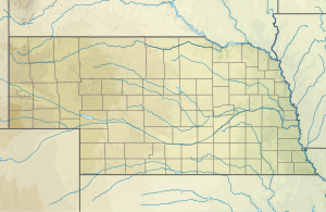
The Loup River in
Nebraska, showing the North and South Loup rivers
342:
486:
Discharge includes water removed by Loup River Power Canal
388:
A diversion dam southwest of Genoa diverts water to the
317:, approximately 68 miles (109 km) long, in central
299:
291:
281:
242:
226:
214:
171:
155:
147:
138:
128:
118:
113:
105:
97:
Location of the mouth of the Loup River in
Nebraska
39:
361:, approximately 5 miles (8 km) northeast of
8:
373:, where it is joined from the north by the
313:(pronounced /lup/) is a tributary of the
411:
333:. The name of the river means "wolf" in
558:
483:2,584 cu ft/s (73.2 m/s)
452:1,148 cu ft/s (32.5 m/s)
303:15,000 sq mi (39,000 km)
566:
564:
562:
36:
468:975 cu ft/s (27.6 m/s)
7:
437:230 cu ft/s (6.5 m/s)
543:French colonization of the Americas
365:and 20 miles (32 km) north of
685:Rivers of Merrick County, Nebraska
89:
25:
695:Rivers of Colfax County, Nebraska
690:Rivers of Howard County, Nebraska
675:Rivers of Platte County, Nebraska
680:Rivers of Nance County, Nebraska
533:Twin Bridge (Brownlee, Nebraska)
515:
501:
88:
81:
65:
45:
34:River in Nebraska, United States
700:Tributaries of the Platte River
357:The river is formed in eastern
244: • coordinates
173: • coordinates
1:
139:Physical characteristics
283: • elevation
59:; looking downstream (east).
228: • location
157: • location
716:
287:1,424 ft (434 m)
26:
210:
143:
76:
64:
44:
655:Trail of the Loup (1906)
295:68 mi (109 km)
538:List of Nebraska rivers
266:41.39944°N 97.32139°W
195:41.27056°N 98.40111°W
341:trappers after the
271:41.39944; -97.32139
262: /
200:41.27056; -98.40111
191: /
53:Nebraska Highway 39
670:Rivers of Nebraska
55:crossing south of
490:
489:
444:Middle Loup River
337:, named by early
329:southeast of the
307:
306:
16:(Redirected from
707:
643:
642:
635:
629:
628:
621:
615:
614:
607:
601:
600:
593:
587:
586:
579:
573:
568:
525:
520:
519:
518:
511:
506:
505:
504:
459:North Loup River
429:South Loup River
412:
277:
276:
274:
273:
272:
267:
263:
260:
259:
258:
255:
206:
205:
203:
202:
201:
196:
192:
189:
188:
187:
184:
174:
158:
92:
91:
85:
69:
49:
37:
21:
18:North Loup River
715:
714:
710:
709:
708:
706:
705:
704:
660:
659:
651:
646:
637:
636:
632:
623:
622:
618:
609:
608:
604:
595:
594:
590:
581:
580:
576:
569:
560:
556:
529:
528:
523:Nebraska portal
521:
516:
514:
507:
502:
500:
495:
410:
355:
284:
270:
268:
264:
261:
256:
253:
251:
249:
248:
245:
229:
199:
197:
193:
190:
185:
182:
180:
178:
177:
172:
156:
101:
100:
99:
98:
95:
94:
93:
72:
60:
35:
32:
23:
22:
15:
12:
11:
5:
713:
711:
703:
702:
697:
692:
687:
682:
677:
672:
662:
661:
658:
657:
650:
649:External links
647:
645:
644:
630:
616:
602:
588:
574:
557:
555:
552:
551:
550:
545:
540:
535:
527:
526:
512:
497:
496:
494:
491:
488:
487:
484:
481:
476:
472:
471:
469:
466:
460:
456:
455:
453:
450:
445:
441:
440:
438:
435:
430:
426:
425:
422:
419:
416:
409:
406:
396:facilities in
354:
351:
305:
304:
301:
297:
296:
293:
289:
288:
285:
282:
279:
278:
246:
243:
240:
239:
230:
227:
224:
223:
218:
212:
211:
208:
207:
175:
169:
168:
159:
153:
152:
149:
145:
144:
141:
140:
136:
135:
130:
126:
125:
120:
116:
115:
111:
110:
107:
103:
102:
96:
87:
86:
80:
79:
78:
77:
74:
73:
70:
62:
61:
51:Loup River at
50:
42:
41:
33:
24:
14:
13:
10:
9:
6:
4:
3:
2:
712:
701:
698:
696:
693:
691:
688:
686:
683:
681:
678:
676:
673:
671:
668:
667:
665:
656:
653:
652:
648:
640:
634:
631:
626:
620:
617:
612:
606:
603:
598:
592:
589:
584:
578:
575:
572:
567:
565:
563:
559:
553:
549:
546:
544:
541:
539:
536:
534:
531:
530:
524:
513:
510:
509:Rivers portal
499:
492:
485:
482:
480:
477:
474:
473:
470:
467:
465:
461:
458:
457:
454:
451:
449:
446:
443:
442:
439:
436:
434:
431:
428:
427:
423:
420:
417:
414:
413:
407:
405:
403:
399:
395:
394:hydroelectric
391:
386:
384:
380:
376:
372:
368:
364:
360:
359:Howard County
352:
350:
348:
344:
340:
336:
332:
328:
324:
323:United States
320:
316:
312:
302:
298:
294:
290:
286:
280:
275:
247:
241:
238:
234:
233:Platte County
231:
225:
222:
219:
217:
213:
209:
204:
176:
170:
167:
163:
162:Howard County
160:
154:
150:
146:
142:
137:
134:
131:
127:
124:
123:United States
121:
117:
112:
108:
104:
84:
75:
68:
63:
58:
54:
48:
43:
38:
30:
19:
633:
619:
605:
591:
577:
548:Mormon Trail
400:and then in
387:
367:Grand Island
356:
345:band of the
327:Great Plains
315:Platte River
310:
308:
221:Platte River
29:Loup (river)
433:St. Michael
375:Cedar River
269: /
198: /
664:Categories
554:References
475:Loup River
408:Discharges
390:Loup Canal
311:Loup River
300:Basin size
257:97°19′17″W
254:41°23′58″N
183:41°16′14″N
40:Loup River
421:Discharge
371:Fullerton
331:Sandhills
186:98°24′4″W
106:Etymology
493:See also
479:Columbus
464:St. Paul
448:St. Paul
418:Location
402:Columbus
383:Columbus
363:St. Paul
319:Nebraska
237:Nebraska
166:Nebraska
133:Nebraska
114:Location
321:in the
119:Country
424:Notes
398:Monroe
353:Course
347:Pawnee
339:French
335:French
292:Length
151:
148:Source
462:near
415:River
379:Genoa
343:Skidi
216:Mouth
129:State
57:Genoa
309:The
392:to
666::
561:^
385:.
235:,
164:,
641:.
627:.
613:.
599:.
585:.
31:.
20:)
Text is available under the Creative Commons Attribution-ShareAlike License. Additional terms may apply.