48:
29:
55:
442:
About 1 mile (1.6 km) below Pike, the valley widens, and the river begins to meander and to turn more sharply south, receiving
Hutchcroft Creek from the right and Salt Creek from the left near RM 16 (RK 26). Turning southeast again, the river flows by the city of Yamhill, which lies to
375:
454:
617:
435:
and Petch Creek from the right. Continuing east, the stream receives
Fairchild Creek from the left, Haskins Creek from the right, and Cedar Creek from the left before reaching
372:
and falls 2,392 feet (729 m) between source and mouth to an elevation of 75 feet (23 m). It rises northeast of Trask
Mountain, a 3,412-foot (1,040 m) peak at
506:
at about RM 1.0 (RK 1.6) before joining the South
Yamhill River to form the Yamhill River, an 11-mile (18 km) tributary of the Willamette River.
502:, on the left at RM 10 (RK 16). Slightly downstream of RM 4.0 (RK 6.4), Panther Creek enters from the right. The river passes under
825:
47:
648:
254:
699:
574:
618:"United States Geological Survey Topographic Map: Gobblers Knob, Trask Mountain, Fairdale, Carlton, and McMinnville, Oregon, quads"
164:
330:
130:
773:
495:
439:
at RM 20 (RK 32). Shortly thereafter, the river turns southeast, and Turner Creek enters from the left.
820:
515:
423:
Flowing south and then southeast for its first 1 mile (1.6 km), the river receives
Perkins Creek from the
417:
741:
715:
539:
142:
800:
345:
236:
146:
111:
795:
635:
428:
34:
790:
655:
357:
353:
228:
436:
443:
its left, and receives
Rowland Creek and Yamhill Creek, both from the left. From Yamhill to the
451:, which lies to its left. Soon the river reaches Alecs Butte, a 384-foot (117 m) summit at
427:. Heading east, it receives Maroney Creek from the right before reaching the Flying M Ranch and
695:
570:
334:
503:
338:
28:
499:
448:
349:
75:
232:
814:
634:(RM) markers from the mouth to RM 29 (river kilometer 47), upstream of the
318:
215:
91:
785:
590:
444:
424:
210:
631:
432:
413:
348:, the river flows generally east, then southeast, then south past the city of
322:
470:
456:
391:
377:
269:
256:
179:
166:
369:
416:(RM) 31 or river kilometer (RK) 50, lies near the border between
431:
at about RM 26 (RK 42), where it receives Hanna Creek from the
447:, the North Yamhill River flows generally south and roughly parallel to
326:
240:
150:
101:
569:. Portland, Oregon: Oregon Historical Society Press. p. 1063.
368:
The river begins at an elevation of 2,467 feet (752 m) above
694:(Map) (1991 ed.). DeLorme Mapping. § 58–59.
412:, in the Northern Oregon Coast Range. The source, at about
649:"Map 1: The Yamhill River Basin & the Chehalem Valley"
611:
609:
607:
605:
603:
601:
599:
344:
Rising in a remote area in the mountains of northwestern
62:
Location of the mouth of North
Yamhill River in Oregon
420:
and
Yamhill County northwest of the city of Yamhill.
748:. United States Geological Survey. November 28, 1980
722:. United States Geological Survey. November 28, 1980
546:. United States Geological Survey. November 28, 1980
494:
About 1 mile (1.6 km) later, the stream enters
303:
295:
285:
246:
221:
209:
195:
156:
136:
126:
117:
107:
97:
87:
82:
70:
21:
491:, on the left at about RM 13 (RK 21).
565:McArthur, Lewis A.; McArthur, Lewis L. (2003).
654:. Yamhill Basin Council. 2002. Archived from
8:
498:and flows through it, reaching the city of
317:is a 31-mile (50 km) tributary of the
54:
686:
684:
682:
680:
678:
676:
567:Oregon Geographic Names, Seventh Edition
526:
534:
532:
530:
18:
593:search using GNIS source coordinates.
74:Uncertain but probably after a local
7:
356:about 2 miles (3.2 km) east of
746:Geographic Names Information System
720:Geographic Names Information System
544:Geographic Names Information System
14:
616:United States Geological Survey.
307:177 sq mi (460 km)
826:Rivers of Yamhill County, Oregon
53:
46:
27:
589:Source elevation derived from
248: • coordinates
158: • coordinates
16:River in Oregon, United States
1:
118:Physical characteristics
692:Oregon Atlas & Gazetteer
496:Carlton Lake Wildlife Refuge
287: • elevation
197: • elevation
801:GPX (secondary coordinates)
360:to form the Yamhill River.
331:Northern Oregon Coast Range
329:. It drains an area of the
223: • location
138: • location
131:Northern Oregon Coast Range
842:
201:2,467 ft (752 m)
796:GPX (primary coordinates)
771:Map all coordinates using
333:, as well as part of the
205:
122:
41:
33:North Yamhill River near
26:
779:Download coordinates as:
516:List of rivers of Oregon
299:31 mi (50 km)
143:Siuslaw National Forest
471:45.32028°N 123.18444°W
392:45.37139°N 123.45639°W
291:75 ft (23 m)
270:45.22583°N 123.14500°W
180:45.39750°N 123.42306°W
791:GPX (all coordinates)
540:"North Yamhill River"
661:on December 26, 2004
476:45.32028; -123.18444
397:45.37139; -123.45639
275:45.22583; -123.14500
185:45.39750; -123.42306
466: /
387: /
354:South Yamhill River
315:North Yamhill River
266: /
176: /
22:North Yamhill River
630:The maps include
335:Willamette Valley
311:
310:
833:
821:Rivers of Oregon
758:
757:
755:
753:
738:
732:
731:
729:
727:
716:"Trask Mountain"
712:
706:
705:
688:
671:
670:
668:
666:
660:
653:
645:
639:
636:Flying M Airport
629:
627:
625:
613:
594:
587:
581:
580:
562:
556:
555:
553:
551:
536:
504:Oregon Route 99W
490:
489:
487:
486:
485:
483:
478:
477:
472:
467:
464:
463:
462:
459:
429:Flying M Airport
418:Tillamook County
411:
410:
408:
407:
406:
404:
399:
398:
393:
388:
385:
384:
383:
380:
339:Willamette River
281:
280:
278:
277:
276:
271:
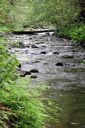
267:
264:
263:
262:
259:
198:
191:
190:
188:
187:
186:
181:
177:
174:
173:
172:
169:
159:
139:
57:
56:
50:
35:Flying M Airport
31:
19:
841:
840:
836:
835:
834:
832:
831:
830:
811:
810:
809:
808:
807:
806:
805:
766:
761:
751:
749:
740:
739:
735:
725:
723:
714:
713:
709:
702:
690:
689:
674:
664:
662:
658:
651:
647:
646:
642:
623:
621:
615:
614:
597:
588:
584:
577:
564:
563:
559:
549:
547:
538:
537:
528:
524:
512:
481:
479:
475:
473:
469:
468:
465:
460:
457:
455:
453:
452:
449:Oregon Route 47
402:
400:
396:
394:
390:
389:
386:
381:
378:
376:
374:
373:
366:
352:. It joins the
288:
274:
272:
268:
265:
260:
257:
255:
253:
252:
249:
224:
196:
184:
182:
178:
175:
170:
167:
165:
163:
162:
157:
137:
66:
65:
64:
63:
60:
59:
58:
37:
17:
12:
11:
5:
839:
837:
829:
828:
823:
813:
812:
804:
803:
798:
793:
788:
782:
776:
769:
768:
767:
765:
764:External links
762:
760:
759:
733:
707:
700:
672:
640:
595:
582:
575:
557:
525:
523:
520:
519:
518:
511:
508:
403:Trask Mountain
365:
362:
346:Yamhill County
309:
308:
305:
301:
300:
297:
293:
292:
289:
286:
283:
282:
250:
247:
244:
243:
237:Yamhill County
225:
222:
219:
218:
213:
207:
206:
203:
202:
199:
193:
192:
160:
154:
153:
147:Yamhill County
140:
134:
133:
128:
124:
123:
120:
119:
115:
114:
109:
105:
104:
99:
95:
94:
89:
85:
84:
80:
79:
72:
68:
67:
61:
52:
51:
45:
44:
43:
42:
39:
38:
32:
24:
23:
15:
13:
10:
9:
6:
4:
3:
2:
838:
827:
824:
822:
819:
818:
816:
802:
799:
797:
794:
792:
789:
787:
784:
783:
781:
780:
775:
774:OpenStreetMap
772:
763:
747:
743:
742:"Alecs Butte"
737:
734:
721:
717:
711:
708:
703:
701:0-89933-235-8
697:
693:
687:
685:
683:
681:
679:
677:
673:
657:
650:
644:
641:
637:
633:
619:
612:
610:
608:
606:
604:
602:
600:
596:
592:
586:
583:
578:
576:0-87595-277-1
572:
568:
561:
558:
545:
541:
535:
533:
531:
527:
521:
517:
514:
513:
509:
507:
505:
501:
497:
492:
488:
450:
446:
440:
438:
434:
430:
426:
421:
419:
415:
409:
371:
363:
361:
359:
355:
351:
347:
342:
340:
336:
332:
328:
324:
320:
319:Yamhill River
316:
306:
302:
298:
294:
290:
284:
279:
251:
245:
242:
238:
234:
230:
226:
220:
217:
216:Yamhill River
214:
212:
208:
204:
200:
194:
189:
161:
155:
152:
148:
145:, in western
144:
141:
135:
132:
129:
125:
121:
116:
113:
110:
106:
103:
100:
96:
93:
92:United States
90:
86:
81:
77:
73:
69:
49:
40:
36:
30:
25:
20:
778:
777:
770:
750:. Retrieved
745:
736:
724:. Retrieved
719:
710:
691:
663:. Retrieved
656:the original
643:
622:. Retrieved
591:Google Earth
585:
566:
560:
548:. Retrieved
543:
493:
441:
422:
367:
343:
337:west of the
314:
312:
752:January 26,
726:January 26,
665:January 22,
624:January 24,
620:. TopoQuest
550:January 25,
482:Alecs Butte
474: /
461:123°11′04″W
395: /
382:123°27′23″W
358:McMinnville
273: /
261:123°08′42″W
229:McMinnville
183: /
171:123°25′23″W
815:Categories
632:river mile
522:References
480: (
458:45°19′13″N
414:river mile
401: (
379:45°22′17″N
323:U.S. state
304:Basin size
258:45°13′33″N
168:45°23′51″N
370:sea level
71:Etymology
510:See also
227:between
83:Location
76:Kalapuya
500:Carlton
350:Yamhill
321:in the
112:Yamhill
88:Country
698:
573:
364:Course
327:Oregon
296:Length
241:Oregon
233:Dayton
151:Oregon
127:Source
108:County
102:Oregon
659:(pdf)
652:(PDF)
445:mouth
425:right
211:Mouth
98:State
78:tribe
754:2009
728:2009
696:ISBN
667:2009
626:2009
571:ISBN
552:2009
437:Pike
433:left
313:The
231:and
786:KML
325:of
817::
744:.
718:.
675:^
598:^
542:.
529:^
341:.
239:,
235:,
149:,
756:.
730:.
704:.
669:.
638:.
628:.
579:.
554:.
484:)
405:)
Text is available under the Creative Commons Attribution-ShareAlike License. Additional terms may apply.