29:
41:
226:), with a dry winter. This climate is characterized by large seasonal temperature differentials and a hot summer (at least one month averaging over 22 °C (72 °F)), and cold winters having monthly precipitation less than one-tenth of the wettest summer month.
234:
The plain hosts extensive broadleaf deciduous forests, which trend into conifer forests on the northern edge. Oaks are most common in the southern half of the region, accompanied by maple, elm and ash. Farther north, forests are characterized by
Mongolian oak
428:
167:, in the region historically known as Manchuria. The plain is surrounded by mountains on the north and east, and supports some of China's largest forest tracts. There are also extensive low-lying wetlands, which support important bird populations.
421:
414:
746:
119:
715:
680:
620:
705:
685:
538:
751:
599:
675:
440:
73:
594:
589:
710:
700:
665:
635:
512:
507:
497:
457:
260:
The floodplain at the mouth of the Liao River is a large wetland that supports waterfowl, including the endangered
Manchurian crane (
690:
640:
630:
625:
388:
220:
579:
543:
736:
604:
533:
487:
467:
645:
253:), dominate. Throughout, the plain is heavily converted to agriculture, taking advantage of the climate and the fertile
741:
650:
558:
548:
695:
660:
28:
492:
223:
215:
655:
482:
477:
406:
553:
584:
563:
502:
462:
176:
160:
528:
472:
273:
56:
249:
182:
340:
261:
237:
437:
243:
190:
363:
194:
730:
296:
197:
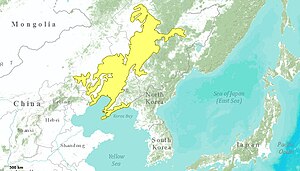
mountains to the north. The southern half of the region is the watershed of the
186:
181:
The
Northeast China Plain is the largest single plain in China, bordered by the
164:
104:
40:
198:
61:
134:
121:
443:
254:
202:
156:
318:
99:
68:
362:
Kottek, M.; Grieser, J.; Beck, C.; Rudolf, B.; Rubel, F. (2006).
410:
364:"World Map of Koppen-Geiger Climate Classification Updated"
613:
572:
521:
450:
113:
92:
84:
79:
67:
55:
50:
21:
422:
247:). In drier areas, stands of sawtooth oak, (
8:
429:
415:
407:
389:"Dataset - Koppen climate classifications"
159:(WWF ID: PA0430) covers the flat interior
297:"Northeast China Plain deciduous forests"
88:232,500 km (89,800 sq mi)
33:Flower Sea Scenic Spot in Fanhe, Tieling
285:
154:Northeast China Plain deciduous forests
22:Northeast China Plain deciduous forests
163:and neighboring adjacent northwestern
18:
747:Temperate broadleaf and mixed forests
441:temperate broadleaf and mixed forests
341:"Major Land-type Categories of China"
291:
289:
216:Humid continental climate, hot summer
7:
74:Temperate broadleaf and mixed forest
14:
299:. World Wildlife Federation (WWF)
213:The climate of the ecoregion is
39:
27:
45:Ecoregion territory (in yellow)
1:
221:Köppen climate classification
752:Geography of Northeast China
201:, which runs south into the
16:Ecoregion in Northeast China
621:Central China loess plateau
549:East European forest steppe
369:. Gebrüder Borntraeger 2006
768:
174:
321:. Resolve, using WWF data
38:
26:
539:Crimean Submediterranean
319:"Map of Ecoregions 2017"
171:Location and description
737:Palearctic ecoregions
686:South Sakhalin–Kurile
671:Northeast China Plain
241:) and Daurian birch (
189:to the east, and the
177:Northeast China Plain
161:Northeast China Plain
742:Ecoregions of China
274:Ecoregions in China
185:on the border with
131: /
696:Taiheiyo evergreen
676:Qin Ling Mountains
661:Nihonkai evergreen
631:Changbai Mountains
250:Quercus acutissima
183:Changbai Mountains
135:43.417°N 124.417°E
724:
723:
595:Eastern Anatolian
590:Central Anatolian
580:Caspian Hyrcanian
544:Dinaric Mountains
262:Red-crowned crane
238:Quercus mongolica
150:
149:
759:
701:Taiheiyo montane
666:Nihonkai montane
636:Changjiang Plain
605:Zagros Mountains
534:Central European
513:Western European
488:English Lowlands
431:
424:
417:
408:
401:
400:
398:
396:
385:
379:
378:
376:
374:
368:
359:
353:
352:
350:
348:
337:
331:
330:
328:
326:
315:
309:
308:
306:
304:
293:
146:
145:
143:
142:
141:
136:
132:
129:
128:
127:
124:
43:
31:
19:
767:
766:
762:
761:
760:
758:
757:
756:
727:
726:
725:
720:
609:
568:
517:
446:
435:
405:
404:
394:
392:
387:
386:
382:
372:
370:
366:
361:
360:
356:
346:
344:
343:. UN University
339:
338:
334:
324:
322:
317:
316:
312:
302:
300:
295:
294:
287:
282:
270:
244:Betula dahurica
232:
230:Flora and fauna
211:
191:Greater Khingan
179:
173:
140:43.417; 124.417
139:
137:
133:
130:
125:
122:
120:
118:
117:
109:
46:
34:
17:
12:
11:
5:
765:
763:
755:
754:
749:
744:
739:
729:
728:
722:
721:
719:
718:
713:
708:
703:
698:
693:
691:Southern Korea
688:
683:
678:
673:
668:
663:
658:
653:
651:Huang He Plain
648:
643:
641:Daba Mountains
638:
633:
628:
626:Central Korean
623:
617:
615:
611:
610:
608:
607:
602:
600:Euxine–Colchic
597:
592:
587:
582:
576:
574:
570:
569:
567:
566:
561:
556:
551:
546:
541:
536:
531:
525:
523:
522:Eastern Europe
519:
518:
516:
515:
510:
505:
500:
498:North Atlantic
495:
490:
485:
480:
475:
470:
465:
460:
454:
452:
451:Western Europe
448:
447:
436:
434:
433:
426:
419:
411:
403:
402:
380:
354:
332:
310:
284:
283:
281:
278:
277:
276:
269:
266:
231:
228:
210:
207:
195:Lesser Khingan
175:Main article:
172:
169:
148:
147:
115:
111:
110:
108:
107:
102:
96:
94:
90:
89:
86:
82:
81:
77:
76:
71:
65:
64:
59:
53:
52:
48:
47:
44:
36:
35:
32:
24:
23:
15:
13:
10:
9:
6:
4:
3:
2:
764:
753:
750:
748:
745:
743:
740:
738:
735:
734:
732:
717:
716:West Siberian
714:
712:
709:
707:
704:
702:
699:
697:
694:
692:
689:
687:
684:
682:
681:Sichuan Basin
679:
677:
674:
672:
669:
667:
664:
662:
659:
657:
654:
652:
649:
647:
644:
642:
639:
637:
634:
632:
629:
627:
624:
622:
619:
618:
616:
612:
606:
603:
601:
598:
596:
593:
591:
588:
586:
583:
581:
578:
577:
575:
571:
565:
562:
560:
557:
555:
552:
550:
547:
545:
542:
540:
537:
535:
532:
530:
527:
526:
524:
520:
514:
511:
509:
506:
504:
501:
499:
496:
494:
491:
489:
486:
484:
481:
479:
476:
474:
471:
469:
466:
464:
461:
459:
456:
455:
453:
449:
445:
442:
439:
432:
427:
425:
420:
418:
413:
412:
409:
395:September 14,
390:
384:
381:
373:September 14,
365:
358:
355:
342:
336:
333:
325:September 14,
320:
314:
311:
298:
292:
290:
286:
279:
275:
272:
271:
267:
265:
263:
258:
256:
252:
251:
246:
245:
240:
239:
229:
227:
225:
222:
218:
217:
208:
206:
204:
200:
196:
192:
188:
184:
178:
170:
168:
166:
162:
158:
155:
144:
116:
112:
106:
103:
101:
98:
97:
95:
91:
87:
83:
78:
75:
72:
70:
66:
63:
60:
58:
54:
49:
42:
37:
30:
25:
20:
670:
393:. Retrieved
391:. World Bank
383:
371:. Retrieved
357:
345:. Retrieved
335:
323:. Retrieved
313:
303:December 28,
301:. Retrieved
259:
248:
242:
236:
233:
214:
212:
180:
153:
151:
706:Tarim Basin
347:January 21,
187:North Korea
165:North Korea
138: /
114:Coordinates
105:North Korea
731:Categories
656:Manchurian
478:Cantabrian
444:ecoregions
438:Palearctic
280:References
199:Liao River
62:Palearctic
614:East Asia
573:West Asia
554:Pannonian
255:chernozem
203:Bohai Sea
157:ecoregion
93:Countries
80:Geography
646:Hokkaidō
585:Caucasus
564:Sarmatic
508:Pyrenees
503:Po Basin
463:Atlantic
458:Apennine
268:See also
126:124°25′E
493:Madeira
257:soils.
209:Climate
123:43°25′N
51:Ecology
711:Ussuri
559:Rodope
529:Balkan
483:Celtic
473:Baltic
468:Azores
367:(PDF)
224:(Dwa)
100:China
69:Biome
57:Realm
397:2019
375:2019
349:2020
327:2019
305:2019
193:and
152:The
85:Area
264:).
733::
288:^
205:.
430:e
423:t
416:v
399:.
377:.
351:.
329:.
307:.
235:(
219:(
Text is available under the Creative Commons Attribution-ShareAlike License. Additional terms may apply.